
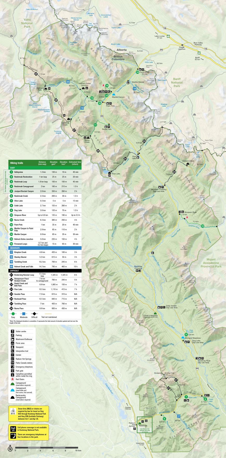
The Rockwall Trail is a 55 km-long backpacking trip between the Paint Pots and Floe Lake Trailheads in Kootenay National Park in the Canadian Rockies. The horseshoe-shaped route travels beside the Rockwall with 900 m high sheer cliffs.
It’s a series of trails strung together – Ochre Creek Trail, Helmet Creek Trail, Rockwall Pass Trail, Wolverine Pass Trail, Tumbling Pass Trail, Numa Pass Trail, and Floe Lake Trail.
Reservations are necessary from the Parks Canada website. Reservations open on March 22, 2023. Make them right at 8:00 am as popular dates book up in under 5 minutes! Book each individual campsite, so prepare a few different itinerary options and dates, number of tent pads (up to 10 people in a group with 3 tent pads, only one tent per pad), number of hikers with full names and emergency contact info, and a credit card
Cost: Wilderness permits for backcountry camping $10.02/person/night. National Park entry pass to park your car at the trailheads from the drive-up entrance booth or a visitor centre at each park – $10/person/day or $20/day for families or groups in the same car. A Parks Canada Discovery annual pass covers people in the same car. Reservation fees $11.50 per reservation (up to 10 people on one reservation).
For a four-day trip, a solo hiker would pay at total of $91.58 and less if in a group
Best Time: Snow-free from late July to mid-September. October and before mid-July there is enough snow that avalanches are a hazard and Parks Canada does not accept campground bookings. To see the larch trees after their needles turn golden, hike in mid-September.
Weather: High in the Rocky Mountains. In July and August, average low/high temperatures are 2-21C
Wildlife: bear country, both black bears and grizzly bears Store all your food and toiletries in the bear lockers. Dogs are permitted on leash. No drones. No firearms.
Maps. Signs at all junctions. Basic Kootenay National Park hiking map.
Kootenay National Park Map by Gem Trek Maps is topographic map helpful to visualize the terrain (and elevation gain) for each day.
Gaia GPS app on phones. Know exactly where you are.
Access. The trail traverses the mountains on the west side of Highway 93. There is no public transport.
The two main trailheads are Paint Pots and Floe Lake,13km apart, and a 30-45 minute drive from Lake Louise or Banff and 1 hour from Radium Hot Springs. There is no shuttle service between the two trailheads: two cars, biking, or hitch-hiking.
Accommodation: Kootenay National Park’s Marble Canyon Campground or Castle Mountain, Protection Mountain, and Johnston Canyon campgrounds.
Direction to Hike: Starting from Paint Pots is long but not as steep as the Floe Lake Trail with heavy packs. Also, the best campsite (Floe Lake) is last.
Elevation Gain: 2600m with numerous ups and downs over 4 passes.
Most people hike the trail in 4 or 5 days, but 3-day trips are possible.
ROUTE Time: Most take 4 days.
5-Days – camp at Helmet Falls (15km, +300m, -50m, 4.5-5.5 hours) Tumbling Creek (12km, +640m, -500m, 5-6 hours), Numa Creek (8km, +340m, -700m, 4-5 hours), Floe Lake (10km, +790m, -300m, 4-5 hours). Trailhead (10km, +30m, -730m, 3-4 hours)
4-days – skips the Tumbling Creek campsite for a 20km, +980m, -1200m, 9-11 hours day.
3-days. Paint Pots to Helmet Falls (15km, +300m, -50m, 4.5-5.5 hours), Helmet Falls to Numa Creek (20km, +980m, -1200m, 9-11 hours), Numa Creek to Floe Lake Trailhead (20km, +820m, 1030m, 7-9 hours)
Shorter options:
Helmet Falls/Tumbling Creek Loop: Could do a day hike up to Tumbling Pass on the third day. Floe Lake Overnighter.
Rockwall Pass and Tumbling Pass: Paint Pots to Tumbling Creek Campground. Base camp and do day hikes to Rockwall Pass and Tumbling Pass before hiking back out.
Camping: Five campgrounds – Helmet/Ochre Junction (6km from Paint Pots), Helmet Falls (15km), Tumbling Creek (27km), Numa Creek (35km), and Floe Lake (45km). Floe Lake is by far the most beautiful as the others are in deep creek valleys. There are gravel tent pads, outhouse(s), and a shared cooking area with a few tables with benches and metal food storage lockers. Campfires are allowed inside metal fire rings only at Numa Creek and Helmet Ochre Junction campgrounds.
Paint Pots to Helmet Falls. Distance: 15km | Elevation Gain: 300m | Elevation Loss: 50m | Time: 4.5-5.5 hours
Start on the flat Ochre Creek Trail, cross the Vermillion River. 1 km to Ochre Spring with its orange-red colour. At 3+ km, reach a junction – the trail to Tumbling Creek Campsite goes left and your trail to Helmet Falls campsite goes right. If you go to Tumbling Creek and skip the first campsite at Helmet Falls, you miss Rockwall Pass, one of the most scenic spots on the trail. 6km – Helmet/Ochre Junction Campsite. 15km – junction with the Goodsir Pass Trail and soon the Helmet Falls Campground. 500 m trail to the waterfall. The 2888m-tall bulk of Limestone Peak towers overhead.
Helmet Falls to Tumbling Creek. Distance: 12km | Elevation Gain: 640m | Elevation Loss: 500m | Time: 5-6 hours
From the campground, Rockwall Pass Trail. Gain 400 m over three kilometres, then 200 m downhill over 2km, and 240m gain over the next 4.5 km. Crest 2214m-tall Rockwall Pass at 8.5km. 9 km – junction at Wolverine Pass. The Dainard Creek trail turns right here to descend through Wolverine Pass, the only break in the length of the Rockwall.
Descend 3km and 300 m to Tumbling Creek campground, the final 2km a very steep descent on a switchbacking trail.
Tumbling Creek to Numa Creek. Distance: 8km | Elevation Gain: 340m | Elevation Loss: 700m | Time: 4-5 hours
Paint Pots 10.5km away. Tumbling Pass Trail gains 340m over 3km to 2165m-high Tumbling Pass. Great views of the Rockwall and the huge Tumbling Glacier. Descend 700m over the next 5km.
The junction with the Numa Creek Trail (which leads to Highway 93 6.3 km away), and the Numa Creek Campsite.
Numa Creek to Floe Lake. Distance: 10km | Elevation Gain: 790m | Elevation Loss: 300m | Time: 4-5 hours
Over 7 km to 2355m-high Numa Pass gaining 700. Foster Peak to the southwest and the Rockwall stretches away from you to the north, and views of Floe Lake below you. Descend
300m from the pass to the campsite at Floe Lake.
Floe Lake to Floe Lake Trailhead. Distance: 10km | Elevation Gain: 30m | Elevation Loss: 730m | Time: 3-4 hours
Descend 730m of elevation through recently burned forest, which can be hot and exposed on sunny days with fireweed blooming
