
Day 18 Fri Oct 6
I drove through Katherine doing some research on Western Australia over a coffee. Then started the long drive towards Kununurra located at the eastern extremity of the Kimberley approximately 45 kilometres from the border with the Northern Territory.
WESTERN AUSTRALIA – KIMBERLY, PILBARA, GASCOYNE (Broome, Exmouth, Karratha)
Western Australia driving. Speed limits are limited to 110, with no 130 limits. But there still seem to be no speed cameras on the highway. Road trains up to 55 m long remain common. Rest areas are less common than in Queensland and the Northern Territory.
In Kununurra, I stopped at the Visitors Information and worked on this in the air conditioning. I then went for dinner and did some shopping preparing to drive towards the entrance of Purnululu, about a 250 km drive.
ON Swing Creek rest area.
Day 19 Sat Oct 7
Up at 3, I finished the 100 km drive to the entrance road to the park. I drove the 1 km to the wayside rest area near the Bungle Bungle Caravan Park. There were four 4WD vehicles ready to convoy the 58 km to the park. I joined one giving them $50 as a donation for gas.
PURNULULU NATIONAL PARK WHS (The Bungle Bungles)
Located in the Kimberley region of Western Australia, the Bungle Bungle Range is composed of Devonian-age quartz sandstone eroded over a period of 20 million years into a series of beehive-shaped towers or cones rising 250 metres above the surrounding semi-arid savannah grasslands. The spectacular black and orange banded appearance is formed by biological processes of cyanobacteria (single-cell photosynthetic organisms) which serve to stabilise and protect the ancient sandstone formations. The process of cone karst formation on sandstone – a phenomenon recognised by geomorphologists only recently is still not completely understood. These outstanding examples of cone karst that have eroded over a period of 20 million years are of great beauty and exceptional geological interest.
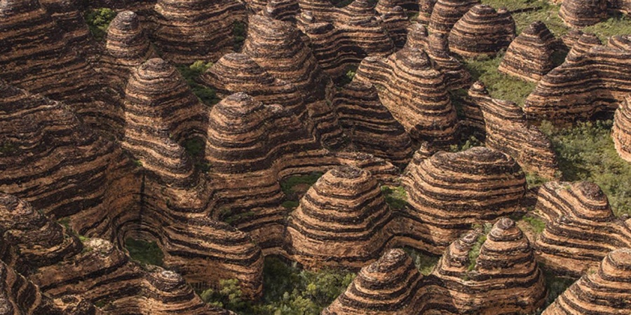
Unique depositional processes and weathering have given these towers their spectacular black and orange banded appearance that undergo remarkable daily and seasonal variation in appearance, including striking colour transitions following rain and with the positioning of the sun.
The intricate maze of towers is accentuated by sinuous, narrow, sheer-sided gorges lined with majestic Livistona fan palms. These and the soaring cliffs up to 250 metres high are cut by seasonal waterfalls and pools, with evocative names such as Echidna Chasm, Piccaninny and Cathedral Gorges.
Temperatures within the park and on the walk trails can reach 40°C (104°F) and radiant heat can increase the temperature to over 50°C (122°F).
Get in. Visitors must carry in all water, food, fuel and other supplies. You will need supplies for three days (even if you are staying one) and enough fuel for a minimum of 300km. Purnululu National Park covers vast distances, so a day trip is not recommended.
The Spring Creek Track into Purnululu National Park is 53km from the Great Northern Highway and can only be accessed by high clearance 4WD from April to November (subject to weather and road conditions), which can take up to 1.5-2 hours to drive. The track is natural earth, not paved or sealed and is corrugated, winding and has hills and creek crossings.
Drive slowly and carefully. The maximum speed limit is 50km per hour. Drive to conditions and look out for livestock and wildlife. Reduce tyre pressure for a smoother ride. Single axle towable units only. Dual axle towable units are not permitted.
Download the free Emergency+ app before your visit which can be used in the event of any emergency to call for assistance. If there is no mobile phone coverage you WILL NOT be able to call 000 but the app will provide you with GPS location details.
Both Lodges, the Purnululu Visitor Centre and Piccaninny Gorge Overnight Hike closed for the 2023 season after 30 September. All Purnululu National Park remains open to visitors. Please book your Walardi campsite and pay your entry fee online on the Park Stay website before you travel.
Accommodation
Lodging
Bungle Bungle Savannah Lodge, ☏+61 8 9168 2213. Eco lodging
Bungle Bungle Wilderness Lodge (near Piccaninny Creek), ☏+61 1300 336 932.
Camping. Bungle Bungle Caravan Park (Bungle Bungle Expeditions). For 2023, this business was not able to renew its license so there is no 4WD access to the park. They were 1 km from the highway.
There are two public campgrounds with water, shared fireplaces and pit toilets. Fees $13, 10 concession. Must be booked.
Walardi campground (12 kilometres from visitor centre, south, near Cathedral Gorge and Picaninny Creek. $13 per adult, $10 concession
Kurrajong campground. To the north near Echidna Chasm with 106 campsites. 7 km from the visitor centre,
Do
Echidna parking area is 20km from the visitor centre.
Echidna Chasm. Distance 2km return. Class 4 and 5. 1 hour. Start in a dry creek bed lined with Livistona Palms. Scramble over the boulders. Between 11 am and 1 pm, when the sun is overhead, Echidna Chasm lights up in brilliant shades of oranges and reds,

Osmand Lookout. Distance 1km return. Class 3. 30 minutes. A short walk with a moderate slope to the lookout takes you to an elevated ridge with beautiful panoramic views of the neighbouring ancient Osmand Range.
Both Mini Palms and Homestead Valley trails can be accessed from the Bloodwoods parking area via the southern end of the Escarpment Trail.
Escarpment Trail. Distance 7.2 km return. Class 3. 2 hours. Passes through open woodlands and spinifex hummocks to the Bloodwoods. Mini Palms is 2.6km along the trail and a further 1km to Homestead Valley.
Cathedral Gorge. 2km return. It has an astonishing natural amphitheatre of red rock. The unusual bee hive-striped formations and deep gorges make it one of the most fascinating geological landmarks. The walk to Cathedral Gorge is 2km return. 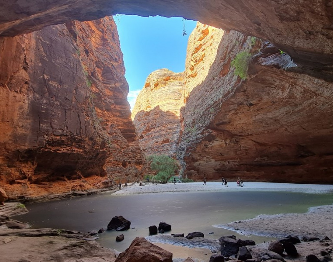 From Piccaninny car park, the walk winds its way through the iconic beehives, heading down between two walls of rock before opening up into Cathedral Gorge. Water pounding through here in the wet season has created a huge amphitheatre of red rock with a pool of water in the middle. The acoustics are so good that music has been played within the gorge. On the return journey to the car park be sure to take the alternative route through the beehives.
The Domes. 700 metres return and packed with the famous ‘beehive’ domes.
Mini Palms Gorge Trail. 4.4km return from the Bloodwood car park. There are steep slopes, narrow edges and large boulders to climb over, under or squeeze between. Climb the stairs to reach two viewing platforms which are surrounded by Livistona palms
My experience. I waited at the highway for someone to arrive that I could hitchhike to the park with. No one arrived. A couple in a motorhome informed me that four 4WDs had been at the caravan park and convoyed to the park leaving at 6 am. I had unfortunately arrived after that and would have missed them anyway.
After Bungal, I drove to Fitzroy Crossing to see Danggu Gorge NP. The Danggu River had destroyed the bridge at Fitzroy Crossing and Google Maps kept directing me on a long detour south around the bridge. I was worried that I would have enough gas, ignored the detour and arrived with a little gas to spare.
Horizontal Falls. North of Derby this is a huge tidal rapid that forms between two headlands as water empties from a bay. The water moves at about 15 knots forming whirlpools and depends on the size of the tides and timing. Watch the YouTube videos of two dudes in a powerboat who went in and then out.
It was a long way to detour and I didn’t go. I was also not sure how to get there in a vehicle as Google Maps said “can’t find a way there”.
I then was considering driving to Derby (known for Australia’s highest tides, Australia’s longest cattle trough, The Prison Boabab Tree, Mowanjum art and culture, and the Aboriginal Norval Gallery). It was 44 km off the highway and not open till 9 am so I continued to Broom.
ON Highway rest area east of Broom.
Day 20 Sun Oct 8
I was up very early on my way to Broome.
BROOME (pop 14,660). A coastal pearling and tourist town in the Kimberley region, 2,046 km (1,271 mi) north of Perth.
On a north–south peninsula, Broome has water on both sides of the town – on the eastern shore is Roebuck Bay with Town Beach’s ‘Staircase to the Moon’, where a receding tide and a rising moon combine to create a stunning natural phenomenon. Roebuck Bay is of international importance for the hosts millions of migrating waders from their breeding grounds in northern Asia and are most common in the summer. A mixed black flying fox and little red flying fox colony of around 50,000 megabats live all year in mangroves.
Pearling. First settled in 1883 due to the pearling industry, which initially involved slavery and indentured labour, pearl diving being an occupation reserved for specific ethnic groups, most prominently from Japan and followed by other Asian countries. Asians, especially Japanese, excelled at pearl diving, with many of them becoming valued citizens in the town. Pearling was a dangerous and sometimes deadly occupation and the town’s Japanese cemetery is the resting place of 919 Japanese divers who lost their lives working in the industry.
This led to numerous racially motivated conflicts, most notably the 1920 race riots between Japanese and Malay residents, resulting in 8 deaths and at least 60 injuries. The Broome community came to “reflect the hierarchy of the pearling industry, which was based on occupation and ethnicity”. White-collar occupations and positions of power were exclusively held by Europeans. As a consequence, racial segregation was common in Broome until the 1970s.
In 1889, a telegraph undersea cable was laid from Broome to Banjuwangi, East Java, connecting to England.
1942 air attacks. Broome was attacked at least four times during World War II, the worst on 3 March 1942, in which at least 86 people died and twenty-two aircraft were destroyed.
Climate. Broome has a hot semi-arid climate susceptible to tropical cyclones
Gas $2.50/l
Cable Beach. This is a gorgeous white sand beach with bits of rock at intervals. It is very deep and has lots of walkers and a few food trucks.
Named for the Java-to-Australia undersea telegraph cable that reaches shore there, Cable Beach is 7 km (4.3 mi) from town and is 22.5 km (14.0 mi) long with white sand, washed by tides that can reach over 9 m (30 ft).
Broome Japanese Cemetery. The Dark Side. Broome’s Japanese cemetery shwos the sacrifices made by pearlers in the early days of the industry. Obelisks mark the graves of over 900 Japanese pearlers, and alongside, the Chinese cemetery is the resting place for members of Broome’s Chinese community. The cemetery is thought to be the largest such site outside of Japan.
Many of the Japanese pearling crews who worked in Broome came from Taji and other villages in the Wakayama Prefecture. A large number of those buried at the Japanese cemetery were divers who died due to decompression sickness or other illnesses related to diving.
The older headstones in the Japanese cemetery are made of local sandstone, carved with the name, birthplace and date of death of the deceased person, sometimes with the name of the person who erected the headstone. Black granite headstones replaced some of the damaged older headstones as part of the restoration of the cemetery restoration in the 1980s.
Broome Historical Museum. Exhibits on aboriginals, pearling, the Japanese, cyclones, aviation and many photographs. $12, 8 reduced.
12 Mile Bird Park. Permanently closed.
Gas Broom $2.50, gas at turn off on Australia National 1 (33 km from Broom) $2.47.
Odometer: 6311. 561 km before turning at Port Hedland, my longest Google Map direction of the trip so far.
Sandfire gas $2.68.4. Filled up as next gas at Port Hedland 275 km.
ON Rest Area past Sandfire. A very quiet night. Cool with doors open. Odometer 6788
Day 21 Mon Oct 9
I was driving at 6. Stopped at the Port Hedland Mall and worked on my S Pacific trip. Bought vape juice at 7 for $15, but then discovered that Australian vape juice has no nicotine to return it for a refund.
Bought counterfeit cigarettes at Port Hedland Gifts and Treasures near the Mall, $70 for 100 rolled cigarettes.
When I was in the smoke shop, a guy brought in my computer, phone and notebook that I had left on the hood of the car and drove off. The screen was cracked and couldn’t be used. One of the dumber things I have ever done travelling.
Gas $2.23
I had a decision to make: either head east to Wittenoom and Karajini NP (300 km) or continue south to Exmouth It was 300 km each way to the park, and I decided to not go.
Wittenoom (The Dark Side) is a former town and a declared contaminated site, 1,420 kilometres (880 mi) north-north-east of Perth, in the Hamersley Range in the Pilbara region of Western Australia. The declared contaminated site comprises 50,000 hectares (120,000 acres), making it the “largest contaminated site in the southern hemisphere”.
The area around Wittenoom was mainly pastoral until the 1930s when mining for blue asbestos began. By 1939, major mining began in Yampire Gorge, which was closed in 1943 when mining began in Wittenoom Gorge. In 1947, a company town was built and, during the 1950s, it was the Pilbara’s largest town. The peak population, in 1961, was 881 (601 males and 280 females). During the 1950s and early 1960s, Wittenoom was Australia’s only supplier of blue asbestos. The mine was shut down in 1966 due to its unprofitability, and growing health concerns from asbestos mining in the area.
In 2007, the townsite was officially degazetted – the town’s name was removed from official maps and road signs, and roads closed that led to contaminated areas. By 2015, six residents remained. In 2017 four, three in 2018, and two in 2021. As of September 2022, Wittenoom had no remaining residents, and demolition of the remaining structures began in May 2023.
In 2018, thousands of travellers still visited the ghost town every year, as a form of extreme tourism. As of September 2022, the town was classified as deserted and closed to the public. A bushfire reportedly hit the area around 26 December 2022, causing damage to remaining buildings and disrupting plans to demolish the site during the 2023 dry season.
Karijini NP. Ancient geological formations of red-layered cliffs that line the spectacular gorges eroded by nature over billions of years. The Pilbara’s gum trees, termite mounds and expansive plains give way to picturesque gorges, waterfalls and the emerald waterholes. A soothing oasis of trees and ferns.
Get in. Situated just north of the Tropic of Capricorn, travellers can access the park from Karratha, Tom Price or Newman via sealed and unsealed roads. Qantas provides daily flights to the town of Paraburdoo, just 100 kilometres from Karijini National Park.
The ideal time to visit Karijini National Park is during Australia’s late autumn, winter and early spring. The days are warm but the nights are cold. The water in the gorge pools can be very cold between April and September.
Traditionally the home of the Banyjima, Kurrama and Innawonga people, the word Karijini is the Banyjima name for Hamersley Range.
Mount Meharry
I also had to decide if I would take a 48 km detour to see Murujunga and again decided not to.
Murujuga Cultural Landscape. Tentative WHS.
The Traditional Custodians of Murujuga are the Ngarluma, Yindjibarndi, Yaburara, Mardudhunera and Wong-Goo-Tt-Oo groups, collectively referred to as Ngurra-ra Ngarli, Murujuga, the Aboriginal traditional name for the Dampier Archipelago and surrounds, includes the Burrup Peninsula in the Pilbara region. It is a narrow peninsula of land extending approximately 22 kilometres from the mainland, a group of 42 islands, islets and rocks and the surrounding sea up to 40 kilometres from the port of Dampier (Murujuga Aboriginal Corporation 2016). With more than one million images in an area of more than 37,000 hectares, Murujuga is home to one of the most significant and diverse collections of petroglyphs in the world which documents the transition of an arid maritime cultural landscape through time. Murujuga has the densest known concentration of hunter-gatherer petroglyphs anywhere in the world.
The songs and mythologies for many of the images, such as Minyuburru (Seven Sisters), the fruit bat and Archaic Face, have important meanings. Archaic Faces.
The Ngurra-ra Ngarli first started living and using this part of the Pilbara coastal plain around 50,000 years ago, when the coastline was about 100 kilometres away. At that time Murujuga was wetter and warmer than it is now. The faunal assemblage is no longer found in this part of Australia, such as nail-tailed wallabies and crocodiles. During the last ice age (between 30,000 and 18,000 years ago), when the coastline was 160 kilometres away, Ngurra-ra Ngarli lived in the Murujuga Ranges as well as other desert refugia. A number of petroglyphs of animals are now extinct, such as thylacines (Tasmanian Tiger) and a fat-tailed species of kangaroo. More recent petroglyphs depict fish, turtles, dugongs and small marsupials that now live on the islands.
The many stone features of Murujuga include standing stones, fish traps, stone arrangements, hunting hides and domestic structures. Some standing stones are thalu sites, places where ceremonies are carried out. Stone sites range from single monoliths to extensive alignments comprising at least three or four hundred standing stones
It was a 200 km detour to the north to see this WHS. Pass through a pancake-flat, treeless landscape to Exmouth. The defining feature was thousands of large, conical, yellow/orange termite mounds.
I drove through Exmouth and continued onto the lighthouse where I arrived just after sundown. There were a lot of people who had driven up here for the huge panoramic view.
EXMOUTH Dates from 1963, a relatively new town.
Gas $139 for 95
Vlamingh Head Lighthouse, North West Cape. 20 km from Exmouth on top of a high hill. Built in 1912, the light is 12 m high and the light reaches 19 nautical miles. The LH is 5 m in diameter.
ON Vlamingh Head LH. There were two picnic tables behind a small building next to the LH. I had dinner and slept there.
Mileage: 872 km (247,660)
Day 22 Tue Oct 10
Despite the heavy wind, the blackflies were terrible in the morning. I watched an OK sunrise at 6:55 during breakfast. With good wifi, I hung around till about 08:30 with my blackfly head net.
Jurabi Turtle Center. Has several storyboards about the three common turtles at Ningaloo. I walked down to the beach but saw no turtles.
Jurabi Coast Park.
Milyering Discovery Center. It opened at 9 a.m., I saw the good information in the centre and rented a snorkel, mask and fins $12, $15 overnight.
Turtles. The best beaches to see turtles mating and on the shore are Workai and Tristal.
Yardie Creek is about as far south as most people go at Ningaloo. The creek when high requires a high clearance 4WD.
NINGALOO COAST WHS
1,200km (745 mi) north of Perth, the fringing Ningaloo Reef is a sparkling gem in Western Australia’s crown. Ningaloo’s most notable visitors are the whale sharks along with manta rays, turtles or humpback whales during their migration.
The 604,500-hectare marine and terrestrial property on the remote western coast of Australia along the East Indian Ocean includes one of the longest near-shore reefs in the world. On land, the site features an extensive limestone karst system and a network of underground caves and water courses.
An estimated 300 to 500 whale sharks aggregate annually between March and July coinciding with mass coral spawning events and seasonal nutrient upwelling causing a peak in productivity making this the largest documented aggregation in the world.
The marine portion has high habitat diversity that includes lagoon, reef, open ocean, the continental slope and the continental shelf. Intertidal systems include rocky shores, sandy beaches, estuaries, and mangroves. The arid terrestrial karst system has subterranean water bodies with a substantial network of caves, conduits, and groundwater streams. The Cape Range Peninsula is recognized for its high levels of species richness and endemism, particularly for birds and reptiles.
300 coral species, 700 reef fish, 650 molluscs, 600 crustaceans species and more than 1,000 species of marine algae, 155 sponges and 25 new species of echinoderms add to the significance of the area. The unusual diversity of marine turtle species has an estimated 10,000 nests deposited along the coast annually.
The combination of relict rainforest fauna and small fully aquatic invertebrates within the same cave system is exceptional. The diversity of reptiles and vascular plants in the drylands is also unusual.

My experience
Cape Range NP. Enter the park and pay the $15 entry fee at a pay station. Cape Range is a low rise of eroded sedimentary/limestone rock. There are over 500 known caves, but few with water. Most are dry and mainly have insects. There are several hikes mentioned in the comprehensive Ningaloo Coast booklet. The range can also be accessed from the east side by two roads, about 11 km off the highway.
Ningaloo Reef NP. This is the ocean/beach part of the WHS and consists of many separate sanctuaries. There are several campsites set next to the dunes and ocean. Book at parkstay.dbca.wa.gov.au. There were none available when I was there.
Turquoise Bay has two snorkelling sites. The beach site is good for beginners with the reef right off the beach and no currents. The Drift snorkel is accessed from a separate car park. Walk south (left) along the beach for at least 100m before entering the water. Swim straight out and let the current carry you north over the dense, fish-filled coral gardens. Exit the water before reaching the sandbar. Moderate to strong currents due to a break in the reef further out, weak or inexperienced swimmers are not advised to attempt this snorkel. It has good fish.
OTHER SNORKELING SITES AT NINGALOO
All are easily accessible from the shore and showcase over 220 species of coral and over 500 species of fish.
Lakeside. All-tide snorkelling spot for swimmers of moderate to high fitness and capability. From the car park, walk 500m south (left) along the beach past the first Sanctuary Zone marker before entering the water. Snorkel out around 100m to find the most spectacular coral formations which are located between the shore markers and the two yellow floating buoys. See turtles, bigger reef or pelagic fish, stingrays and harmless reef sharks.
Oyster Stacks
Great for families as just steps from the shore in calm, shallow water. The shoreline is rocky with some sharp oyster-shelled areas. Enter the water at the end of the walking track and snorkel either north or south. Shallow, so only go at a high tide of 1.2m or higher to avoid damaging the fragile corals. The Discovery Center lists the tides when it is best to go here.
CORAL BAY. On the south side of Cape Range National Park. It is not accessible from the north. Drive back through Exmouth and see it on your way south.
I didn’t go to Coral Bay.
Bill’s Bay. Located at the end of Robinson Street in Coral Bay, the sheltered waters of Bill’s Bay make for an ideal swimming and fantastic snorkelling beach. Verdant, fish-filled coral gardens are just a very short swim from the beach.
Ayre’s Rock – a massive coral formation that can be seen from shore at low tide – 300m out from the northern end of the beach.
Purdy Point. 500m south of Bills Bay. Fantastic coral bommies.
Paradise Beach Drift Snorkel. Around Purdy Point and just to the south of Bill’s Bay, For confident swimmers because of a moderate current.
Huge coral formations can be found a short swim from the Paradise Beach shoreline. Keep an eye out for the large patches of brightly coloured lavender coral here.
Five Fingers Reef. 4.5 kilometres south of Coral Bay accessible by four-wheel drive vehicle or a reasonable walk. 200 metres offshore and are home to a huge array of colourful reef fish and other marine life.
The water here is shallow, calm and brimming with marine life close to shore, Five Fingers Reef is the perfect place for children and beginner snorkelers.
Oyster Bridge and The Lagoon require 4WD access.
DIVING
Ningaloo Reef. Ningaloo Marine Park, has whale sharks and migrating humpback whales. The Navy Pier in Exmouth is where the long jetty shelters marine life including giant gropers. Daily tours depart from Exmouth with Dive Ningaloo, and liveaboard diving is available with Sail Ningaloo from Coral Bay.
Rowley Shoals is a group of three ring-shaped reefs located about 300 kilometres (186 miles) off the coast of Western Australia. These reefs are famous for their strong tidal flows which make for exhilarating drift dives. The Shoals are only accessible for a very short time each year around October. Seen best on a liveaboard cruise from Broome.
After seeing Ningaloo, I started the long drive south to Shark Bay.
SHARK BAY WHS
At the most westerly point of the Australian continent on the Indian Ocean coast, Shark Bay has an area of 2.2 million hectares of which about 70% are marine waters). With its islands and the land surrounding it, has three exceptional natural features:
1. Vast sea-grass beds at the Wooramel Seagrass Bank, which are the largest (4,800 km2) and richest in the world. Seagrasses are aquatic flowering plants that form meadows in near-shore brackish or marine waters in temperate and tropical regions, producing one of the world’s most productive aquatic ecosystems. Australia has one of the highest diversity of seagrasses globally, with 12 species occurring in the Bay.
It is one of the few marine areas in the world dominated by carbonates not associated with reef-building corals. Limestone sands are formed by the precipitation of calcium carbonate from hypersaline waters.
Sea grass beds are a haven for marine species, including Green Turtle and Loggerhead Turtle (one of Australia’s most important nesting areas for loggerheads). Increasing numbers of Humpback Whales and Southern Right Whales use Shark Bay as a migratory staging post, and a famous population of Bottlenose Dolphin lives in the Bay. Large numbers of sharks and rays are readily observed, including the Manta Ray.
2. Dugong (‘sea cow’). Shark Bay is one of the world’s most significant and secure strongholds for the protection of Dugong, with a population of around 11,000.
3. Stromatolites (colonies of microbial/algae mats that form hard, dome-shaped deposits which are said to be the oldest life forms on earth and are comparable to living fossils, the first modern, living examples) that the property is most renowned. Analogous structures dominated marine ecosystems on Earth for more than 3,000 million years initially in Proterozoic seas. They are one of the world’s best examples of a living analogue for the study of the nature and evolution of the earth’s biosphere up until the early Cambrian. The hydrologic structure of Shark Bay, altered by the formation of the Faure Sill and a high evaporation,has produced a steep gradient in salinities, creating three biotic zones that have a marked effect on the distribution and abundance of marine organisms. Hamelin Pool’s hypersaline water (almost twice that of seawater) and contributed to extensive beaches consisting entirely of shells. The profusion of peninsulas, islands and bays create a diversity of landscapes and exceptional coastal scenery.
Shark Bay is a refuge for many globally threatened species of plants and animals. Located at the transition zone between two of Western Australia’s main botanical provinces, the arid Eremaean, dominated by Acacia species and the temperate South West, dominated by Eucalyptus species are at the limit of their southern or northern range. The property contains either the only or major populations of five globally threatened mammals, including the Burrowing Bettong (now classified as Near Threatened), Rufous Hare Wallaby, Banded Hare Wallaby, the Shark Bay Mouse and the Western Barred Bandicoot.
Shark Bay is 847km north of Perth or a flight on Regional Express Airlines to a 15 minute drive from the Airport to Monkey Mia.
Two Wheel Drive Access
Hamelin Bay. Indicate what the earth may have looked like about 3.5 billion years ago when stromatolites grew widespread across the water. Stromatolites are up to a metre high are believed to grow at a maximum of 0.3mm per year – they are truly “living fossils”. 80% of the history of all life was stromatolites – for that time, stromatolites were king.
Visitors could view these amazing life forms, without causing damage by walking on a purpose-built jetty and looking down at the Hamelin Pool stromatolites below, but the boardwalk has been closed since a cyclone in 2021 destroyed the boardwalk. A fence prevents access and a sign says crossing it “Penalties Apply”. The stromatolites can still be seen from the Hamelin Pool quarry, however the view is limited. Scenic flights offer a great vantage point and unique perspective of the stromatolites from above.
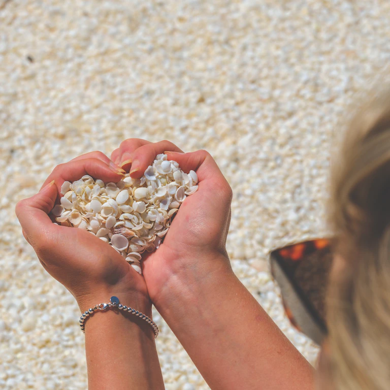
Shell Beach is formed from billions of tiny shells, 45 kms south-east of Denham and 43 km from the Hamelin Pool Stromatolites. Shell Beach is one of only a handful of places on earth where shells replace beach sand. There is no sand, just billions of tiny Shark Bay cockle shells up to 10 metres deep and stretching for over 70 kilometres. The water at Shell Beach is very salty, making it easy to float for those who aren’t strong swimmers – similar to the Dead Sea in Jordan.
In the early 1900s, the shells were quarried and hard packed, cut into blocks and used to construct a number of historic buildings in the nearby town of Denham, some of which can still be seen today such as the Old Pearler Restaurant.
Eagle Bluff. Has a boardwalk to look down on rays and fish.
Little Lagoon is on the outskirts of the National Park just 2 km from Denham and accessible by 2WD. Kayak the lagoons.
Monkey Mia is on the eastern shore of the Peron Peninsula, 23km from Denham. Home to the Monkey Mia dolphins, famous for their ritual of swimming to shore. Four to seven dolphins visit the shore for daily feedings, with Rangers providing them with less than 10% of their total daily intake requirements to ensure they continue to hunt and behave in a wild manner. The feedings take place up to 3 times each morning, between 07:45am and 12 midday. It has a Reserve fee – different from a National Park pass. The Mia part comes from an Aboriginal term for home. Many believe that the Monkey refers to the name of a ship which visited the area, while others believe it refers to pet monkeys that Malaysian pearl farmers (who worked in the area during the 1850s) would have.
Scenic flights see sharks, rays and turtles, perhaps even humpback whales and the elusive dugongs. Watch the cliffs of Francois Peron National Park glow red and orange with a late afternoon flight at sunset. Flights depart from Monkey Mia Airport with a variety of tours.
Four-wheel drive access only.
Francis Peron NP. Has a scenic coastline with dramatic red cliffs and white sandy beaches, rust-red desert earth meeting white beach sand and azure blue water. High clearance 4WDs are essential – make sure to deflate car tyres by the Homestead, where there is a tyre compressor station for your convenience. Camping fees apply. Campfires and pets are not permitted, bring your own water, and remove your own waste. Basic campsites are at Herald Bight, Big Lagoon, Bottle Bay and Gregories. Gas barbecues are supplied. Swimming is not recommended at Cape Peron, due to strong currents.
17 mammals, 98 reptiles and amphibians and more than 230 species of birds including bungarra and thorny devil (lizards), emus and cormorant (birds). Hydroplaning Dolphins, have an unusual technique for catching fish.
Walk the 1.5km Wanamalu Trail between Cape Peron and Skipjack Point.
An unusual feature is salt-lagoon birrada (birridas), land-locked saline lakes re-flooded to create the inland bays of Big Lagoon and Little Lagoon. Big Lagoon is home to dugongs, dolphins and green turtles, and offers camping (4WD access only), while Little Lagoon is a natural nursery for crabs and whiting, and offers day access only with BBQ facilities.
Steep Point. Sitting within the Edel Land National Park (proposed), Steep Point has the spectacular Zuytdorp Cliffs which tower some 170 metres above the ocean and are more than 200 km long all the way south to Kilbarri. Named after the Zuytdorp ship that was wrecked by the rugged coast in the early 1700s, the ship remains on the seabed near the cliffs. Blowholes, shoot sea spray some 20-30 feet into the air. It is only 4WD accessible on 140km of unsealed road, the last 30km of which is a single-lane soft track winding around sand dunes.
Dirk Hartog Island can be accessed by barge transfer, charter boat or light aircraft. The barge departs from Steep Point, which is accessible by high-clearance 4WD only. Guests need to book and camp overnight at Steep Point prior to their barge transfer. Guided half and full-day tours depart from Denham, the main town in Shark Bay (guests are transferred from Denham to Dirk Hartog Island by boat). Light aircraft operate from Monkey Mia Airport.
My Experience. I camped at Hamelin Pools campsite and walked down to the pool and the destroyed boardwalk in the morning. You can see the stromatolites from the shore.
ON Hamelin Pools Parking Area.
Mileage. 700 km. Odometer 248359.
Day 23 Wed Oct 11
In the morning, I drove 56 km to Shell Beach and then to Eagle Bluff and stopped there. I saw no point in continuing on to Denham, Little Lagoon and Monkey Mia.
I then started the drive south to Perth, 693 km from the Overlander Roadhouse.
Gas at Billabong $2.13 just south of the Overlander Roadhouse.
===========================================================
WESTERN AUSTRALIA – WEST, SOUTH, WHEATBELT (Perth, Geraldton, Albany)
From the Overlander Roadhouse, there was 300+ km more bush until 15 km north of Carnarvon where the irrigated land started.
Carnarvon. On the Gascoyne River, it is an agricultural mecca because of irrigation. The main crop is bananas, but there are also vegetables under netting and vineyards.
Gas $2.10
North of Chiverton, the terrain was rolling agricultural land with lots of wheat, the first I had seen thus far in Australia.
Chiverton House Museum, Northampton. Dating from 1865-1885, 130 buildings were built as the first settlement in the area. Chiverton House was added in 1885, had many owners and was condemned in 1967. Has a lot of old farm machinery including plows and tractors. Free
GERALDTON
Museum of Geraldton. Heavily promoted the Houtman Abrollas Islands, now a national park. The Leeuwin Current is one of the few south-flowing currents in the Southern Hemisphere. Because it is warm, it is relatively low in nutrients accounting for the relatively poor fishery on the west coast of Australia. It does however promote corasl farther south than would be expected. Aboriginals and history of European arrival and exploration. Batavia shipwreck of 1619 had a large exhibit. An interesting thing recovered from the wreck was a very nice stone arch meant to be constructed as the portal gate in Jakarta (used as ballast). Large exhibit on all the shipwrecks along the coast. Also with a little bit of everything from flowers to insects. Free
Geraldton Regional Art Gallery. Had two exhibitions: local high school students from grades 7-12. I was given a slip of paper to vote for my favourite. Not much was very good.
Political cartoons from 2022. Divided into several categories, I quite enjoyed this although I didn’t understand most of the background. I was surprised that the ones on COVID-19 were not more critical. The staff at the museum thought Australia handled it well (I thought they had done the worst in the world with their draconian lockdowns). One positive was that local products received a great boost. Free
St Francis Xavier Cathedral. A wonderful church with 2 shades of grey stripes on the columns and walls and orange-white bands on the arches. Crypt exposed under a glass floor. Nice rose stained glass windows. The Ways of the Cross were carved stone basreliefs. A lovely wood-beamed ceiling over the altar and cloister. Mosaic baptismal font. Marble floor.
Point Moore Lighthouse, West End. 34 metres high it was the first all-steel tower built on the mainland of Australia in 1878. With its bold red/white stripes, the lighthouse has become an icon of the port city of Geraldton. Constructed of iron rings in Birmingham England and shipped to Geraldton.
The waters off the point are incredibly wild with reefs everywhere.
Namburg National Park (The Pinnacles). 200 km north of Perth, I stopped here late in the afternoon. Fee $15. There are thousands of limestone pillars up to 4 m tall rising out of the sand. Some are jagged and others look like tombstones. The best way to see them is on the 4 km one-way loop drive with many parking sites. There is also a 1.2 km signed walk that bisects the road. It is thought that they were formed underground up to 500,000 years ago and exposed during the last 6,000 years, being completely exposed only in the last few hundred years. I took many photos in the last light.
ON Rest area about 78 km north of Perth.
Mileage. 819 km
Day 24 Thur Oct 12
I parked in a parkade near Fixpress where I was to have the cracked screen of my Mac Air repaired. $10/half hour. Fixpress wasn’t open so I walked to the Telstra office to correct my birthday and bought another month of phone for $35.
Fixpress still wasn’t open and I left my computer with a note at the food stall across the hall.
I certainly wasn’t going to pay this kind of parking fee to see the sites in Perth so drove to Guildford. I then went to Travelers Autobarn, filled out the kangaroo accident form and had the bent panel straightened so that I could open my door completely.
PERTH (pop 2.1 million) is the capital and largest city of Western Australia and the fourth most populous city in Australia and Oceania. The city has expanded outward from the original British settlements on the Swan River, upon which the city’s central business district and port of Fremantle are situated.
Captain James Stirling founded Perth in 1829 and named after the city of Perth in Scotland, The city’s population increased substantially as a result of the Western Australian gold rushes in the late 19th century. It has grown steadily since World War II due to a high net migration rate. Post-war immigrants were predominantly from the British Isles and Southern Europe, while more recent arrivals see a growing population of Asian descent. Several mining booms in other parts of Western Australia in the late 20th and early 21st centuries saw Perth become the regional headquarters for large mining operations.
Perth contains a number of important public buildings as well as cultural and heritage sites. Notable government buildings include Parliament House, Government House, the Supreme Court Buildings and the Perth Mint. The city is served by Fremantle Harbour and Perth Airport.
History.
Prehistory. People have inhabited the Perth area for at least 45,000 years;
The Dutch Captain Willem de Vlamingh landed first in 1697
Swan River Colony. Perth became the first “full-scale” settlement by Europeans in WA in 1829. Beginning in 1831, hostile encounters between the British settlers and the Noongar people increased. They were forced to camp around swamps and lakes north of the European settlement area.
Convict era and gold rushes. In 1850, at a time when penal transportation to Australia’s eastern colonies had ceased, Western Australia was opened to convicts at the request of farming and business people due to a shortage of labour. Over the next eighteen years, 9,721 convicts arrived in Western Australia aboard 43 ships.
With the discovery of gold at Kalgoorlie and Coolgardie in the late 19th century, Western Australia experienced a mining boom, and Perth’s population grew from approximately 8,500 in 1881 to 61,000 in 1901.
In 1927, Indigenous people were prohibited from entering large swathes of Perth under penalty of imprisonment, a ban that lasted until 1954. Perth’s development and relative prosperity, especially since the mid-1960s, has resulted from its role as the main service centre for the state’s resource industries, which extract gold, iron ore, nickel, alumina, diamonds, mineral sands, coal, oil, and natural gas. Whilst most mineral and petroleum production takes place elsewhere in the state, the non-base services provide most of the employment and income to the people of Perth.
Parking in downtown Perth is exorbitant at $10/half hour. I found Mill Point Reserve, about a 20-minute walk from downtown which was lovely and quiet and a nice walk.
Guildford Town Hall and Library. The library was built in 1900. The Art Deco Town Hall was built in 1937, has a two-story tower and columns in front and is now a community auditorium (2-5 year-olds were having dance classes). Nice stage.
Revolutions Transport Museum, Whiteman. 28 km north of Perth, this is a huge car museum with motorcycles, scooters, and thousands of models. photos, many great old cars (including a Rolls Royce that you can sit in and an 1898 car). There is one building of just muscle cars. One car from 1926 that looked all rusted ran like a clock. Surprisingly there was no ’57 Chevy. The older men who work here take great pride in all the cars. $18, 13 reduced
Rose and Crown. In the NM Hospitality Legends, this hotel dates from 1841. With a “Boutique Hotel” sign, it was mostly a very large outdoor restaurant and pub.
Matagarup Bridge. Over the Swan River connecting the downtown area to Opus Stadium, this is a wonderful construction of three double (each white and black) intersecting, steel tube arches on three piers. 400 m long, deck 9-22 m wide, top of arches are 72 m above the river. Has a 500 m long zip line. It has 900 LED lights capable of 16 million colour combinations.
Perth Zoo. Has all the usual African and Australian animals. $36.30. $28.80 reduced so I didn’t go in. I don’t find zoos very interesting especially when I’ve seen almost everything in the wild or in other zoos.
Old Mill. A white cone shape with a black shingle roof. Has four vanes. Can’t be entered.
I found a great parking spot at the Mill Point Reserve (first hour free and then $2/hour). It was across the highway from the Old Mill. I then walked 1.5 km into downtown, got my repaired computer ($590, replaced the top cover) and walked around downtown to see the sites still open in the late afternoon.
Walsh’s Building. Built in 1923, this art deco four-story high building sits on a prominent corner in downtown Perth. Originally the Economic Store, it was changed to Walsh’s when Walsh’s Menswear took over the bottom floor.
St. Mary’s Cathedral. Occupying an entire block, this was originally built in 1863-65 and two round walls were constructed in the 2000’s adding a huge amount of light. The altar sits in the middle with 6 groups of angled seating around it. The Ways of the Cross were unusual sculptures.
Council House. The 12-story City Hall was built in the 1960s. Rectangular and not of much architectural interest.
Swan Bell Tower. This spectacular tower is all glass and octagonal in shape. There are 8 “floors” and then 20 sections rising to a spire and antennae. There are four metal “sails around the bottom.
Elizabeth Quay Bridge. A lovely curving bridge that is cable-stayed from two lateral arches on one pier. This old area is completely gentrified with many restaurants.
ON Mill Point Reserve
Mileage: 9174
Day 25 Fri Oct 13 (my birthday)
I worked on this post for several hours after not having my computer for 4 days and then walked downtown to see some of the sites not open on Thursday.
I then had a walk about seeing the rest of the museums in the downtown core.
Museum of Performing Art. In the His Majesties Theatre, I don’t think the museum exists anymore.
Art Gallery of Western Australia. Nice galleries but art so so. Good Aboriginal and Torres Islander art. Sandra Hall had some great art about Aboriginal women’s forced integration into white society. The Lister Prize for portraiture was exhibited with some interesting pieces. Free
Institute of Contemporary Art. In a lovely building, the exhibits were not very interesting. Two were videos and one was a confusing painted corrugated metal. Free
Western Australian Museum. Wild Life is a well-done natural history exhibit (I especially learned a lot about termites). Connections is all about immigration, a big component of Australian history. Wars Australia has been involved in, often misguided support of Britain and the US. The astronomy exhibit was dated especially since the advent of the James Webb space telescope. $15, 10 reduced
Berndt Museum of Anthropology. This is supposed to be in the WA Museum but it seems to be absent.
Museum of Perth. A small museum with 6 storyboards outlining the history and one exhibit on cycling around Australia or across the country was quite interesting. Free
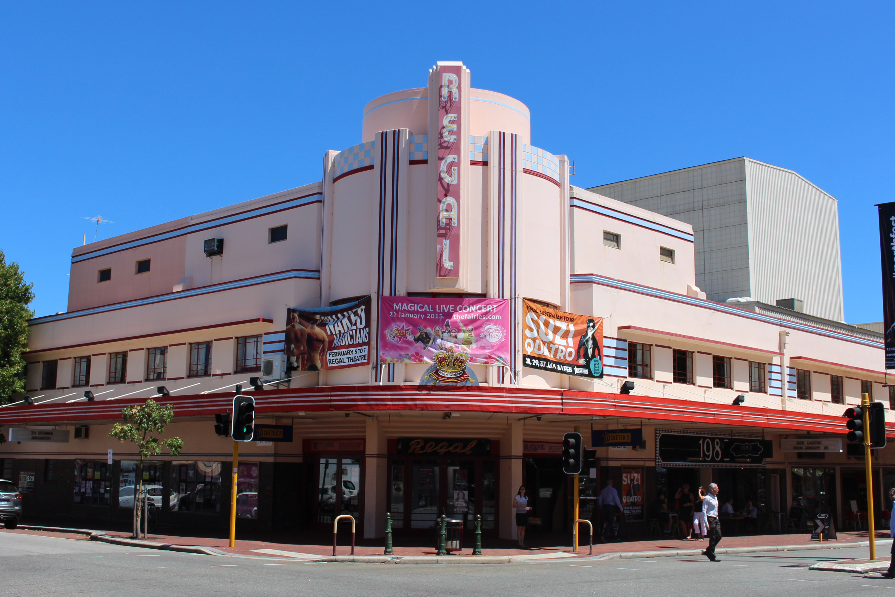
Regal Theatre. In the NM Architectural Delights, it is a fine Art Deco theatre located in the suburb of Subiaco. It was built in 1937 and named for King George VI, who had taken up the throne. It was originally a theatre for films, but in 1977, the Regal was converted into a live theatre. It is one of the few remaining theatres in Perth. It is suited to all forms of theatre, including stage shows, concerts, comedies, operas, film festivals and rock shows. The seating capacity is 1074 people.
Unfortunately, I could not enter the theatre itself, only the lobby.
Kings Park & Botanic Garden. Kings Park is one of the world’s largest inner-city parks at 400 hectares, located next to the Swan River. The Western Australian Botanic Garden has 3,000 species. Nearly two-thirds of the Park is natural bushland containing 319 species of native plants and around 80 bird species. Cafes, cultivated gardens, walk trails, a lot of big trees and the State War Memorial.
Cygnet Cinema. In the NM Architectural Delights was built in 1938 as the Como Theatre, the first purpose-built “talkies” cinema in Perth. 500 seats. The advent of TV and multi-screens was the beginning of its demise. AC was added, and a reno was done. But asbestos in the roof forced its closure in 2021, and it has not opened since.
Market City. A large vegetable market also with Chinese-oriented groceries and live fish. Part of a large strip mall complex.
FREEMANTLE
Army Museum of Western Australia. Exhibits on traditions, Pre-1914 (Boer War), WWI, WWII, POWs, Post WWII (including Vietnam), Guns and Vehicles and Victoria Cross.
Note the weird hours of this museum: Wed, Thur, Fri, and Sun, 10-3, last entry at 1 pm as they say it takes 2 hours to see the museum. Bizarre. Only some army dude would think this up. $15, 10 reduced
AUSTRALIAN CONVICT SITES WHS
Eleven penal sites, among the thousands established by the British Empire, spread across Australian soil in the 18th and 19th centuries. Around 166,000 men, women and children were sent to Australia over 80 years between 1787 and 1868, condemned by British justice to transportation to the convict colonies. Each of the sites had a specific purpose, in terms both of punitive imprisonment and rehabilitation through forced labour to help build the colony. The Australian Convict Sites presents the best surviving examples of large-scale convict transportation and the colonial expansion of European powers through the presence and labour of convicts.
Each is a different type of convict settlement in terms of buildings, ports, infrastructure, and the extraction of resources
Many were convicted for relatively minor offences, some for expressing certain opinions or being political opponents. Women and children from the age of nine were included. They reflected the beliefs about the punishment of crime in 18th and 19th century Europe for the harshness of the punishment used as a deterrent, and of the aim of social rehabilitation through labour and discipline.
The convict settlements simultaneously led to the Aboriginal population being forced back into the less fertile hinterland, and to the creation of a significant source of population of European origin.
The structural integrity depends on the site, especially ones with lengthy periods of abandonment.
The sites included in the serial listing are:
Kingston and Arthur’s Vale Historic Area, Norfolk Island (1788–1814 and 1824–1855)
Old Government House and Domain, Parramatta Park, New South Wales (1788–1856)
Hyde Park Barracks, Sydney, New South Wales (1819–1848)
Brickendon—Woolmers Estates, Longford, Tasmania (1820–1850s)
Darlington Probation Station, Maria Island National Park, Tasmania (1825–1832 and 1842–1850)
Old Great North Road, Wiseman’s Ferry, New South Wales (1828–1835)
Cascades Female Factory, South Hobart, Tasmania (1828–1856)
Port Arthur Historic Site, Port Arthur, Tasmania (1830–1877)
Coal Mines Historic Site, Norfolk Bay, Tasmania (1833–1848)
Cockatoo Island Convict Site, Sydney, New South Wales (1839–1869)
Fremantle Prison, Fremantle, Western Australia (1852–1886)
My experience:
Fremantle Prison. About 10,000 convicts were at Freemantle. Of all the convict sites, only Freemantle appears to be intact and certainly the most interesting. There are three main tours a.Convict Prison Tour (1850-1886) b. True Crime – the most notorious prisoners c. Behind the Bars – history from 1886-1991. This is the one I went on, 1.5 hours $22, 18 reduced. We heard the induction process, the kitchen, exercise areas, and all four of the cell blocks with examples of every cell from the convict days through to the 1991 closure. Legal people and sex offenders were housed separately. Working in the kitchen was the most coveted job. There were never toilets in the prison and buckets were used.
MANDURAH
Mandurah War Memorial. A large memorial next to the water. There are four flag poles, 15 cement columns and a long stone wall listing all the conflicts Australia has been involved in since the 1885 Sudan episode, Boer War 1899-1903, WWI 1914-17, WWII 1939-45, Vietnam
ON Mandurah War Memorial parking lot.
Mileage 115 km
Day 25 Sat Oct 14
I spent the morning getting caught up on my WA post and Nomad Mania sites. BUNBURY
Bunbury Lighthouse. A very tall LH with an attractive black/white checked paint job. It can’t be entered and there was no information sign.
Bunbury Regional Art Gallery. In the 1897 Sisters of Mercy Convent (painted a lovely pink with white trim), had a nice exhibit called “Ulternative Archive” a collection of 13 exhibitions in SW Australia. Also a large exhibit from schools grades 7-12, the pottery of Stewart Scammer (with of video of him turning pots and the firing of his kiln. Free
Wonnerup House, Wonnerup. The current house was built in 1859 by George Layman Jr. one year after the original house built in 1837 by his father, George Layman Sr., was destroyed by fire. The dairy and kitchen survived the fire and the sables and a blacksmith workshop were later additions. In the 1870s, George Layman Jr. donated land near Wonnerup House for a school, which was built in 1873.
In 1827 George Layman, then 17 years old, immigrated to Australia from England and settled in Van Diemen’s Land, Tasmania, with his brother Charles. In 1829, Layman was attacked and robbed of all his money by escaped convicts, and left for the Swan River Colony, in 1829.
Relations between the European settlers and the native Wardandi people were strained. In 1841, George Layman was speared to death by Wardandi elder Gaywal. A manhunt for Layman’s killer and an unknown number of Aboriginals were killed. The posse eventually shot Gaywal and two of his sons were imprisoned on Rottnest Island.
In 1858, the Layman cottage burned to the ground and 20-year-old George Layman Jr. built the current Wonnerup House. In the 1880s and 1890s, Wonnerup House was one of the district’s most lucrative dairy farms. At its peak, the farm had an area of over 1,000 hectares (2,500 acres). In 1962, with the death of the last Layman sister, the farm was sold and acquired by the National Trust of Australia in 1971.
The house is a narrow, long stone structure that has been whitewashed. The roof was damaged and all the furniture was removed except for a cheese press. $10, 7 reduced
Busselton
Leeuwin-Naturaliste NP. Named after the two locations at either end of the park which have lighthouses, Cape Leeuwin and Cape Naturaliste, it is the busiest national park in Western Australia with 2.33 million visitors through 2008–2009.
The park extends over 100 miles, from Cape Naturaliste in the north to Cape Leeuwin in the south. It is composed of 28 fragmented separate reserves, some only a narrow coastal strip. It has many limestone and granite outcrops, beaches with well-known surf breaks (Supertubes, Yallingup Beach, and Smiths Beach), coastal cliffs, aeolian dunes and caves, Leeuwin-Naturaliste Ridge runs north and south parallel to the coast and is composed of coastal dune limestone and the Margaret Plateau composed of granitic and anorthositic gneisses.
Cape Naturaliste Lighthouse. Sitting on a bluff 100 m above the water, it has panoramic views over 270°. Built in 1903, it is stone 20 m high and 14′ in diameter. The lantern and fresnel lens were made in Birmingham and have a distance of 25 nautical miles.
The clock weighs 12.5 tons and floats in a hollow turntable with 156.6 kg of liquid mercury (12 litres). If there is no power, it takes no effort to turn the lens. $5/4 with no tour and $16/12 with a tour and visit inside the LH
After the LH, I stopped at Meelin Beach for a quick swim and a well-needed shower.
Ngilgi Cave. The two main rooms are 35 and 45 metres high and have a full range of cave formations – stalagmites, stalactites, helicules, straws, pillars, flowstones and columns. $36, 32 reduced including the heritage tour. Note that it closes at 5 but the last entry is at 4. See on a semi-guided tour.
Margaret River Wineries. I drove on Cave Road from Ngilgi Cave to Margaret River and must have passed 50 wineries. All had big impressive gates and the sign “Cellar Door”. There are 215 wineries in the Margaret River area supplying 3.5% of Australian wine but over 20% of the premier export market.
Margaret River
ON Lions Park just outside of town. .
Mileage: 286 km 9577
Day 26 Sun Oct 15
I was up early and drove the 125 km to my cousin’s home in Bridgetown.
I spent the day casting a sculpture out of aluminum, melted to 600°C. It was a fascinating day. Kim Perrier has an amazing sculpture garden and is a very talented guy.
Day 27 Mon Oct 16
We had a lazy day spent chatting and gossiping. We toured the sculpture garden at night which is the best time. Maree and Kim are excellent hosts.
Day 28 Tue Oct 17
I was off at 10 am to continue across South Australia.
It was a lovely drive down to Albany going through some magnificent forests in three national parks – Shannon, Mt Franklin and Walpole-Nornalup. On the last one, I detoured to the Valley of the Giants with a fallen giant 400-year-old Tingle that fell in 1990 and now forms the basis of the Tree Top Walk (400 m long, 40 m above the ground, $21, 15.5 reduced).
Mandalay Beach. A golden beach with very fine sand, about 15 km off the highway where it turns east to go towards Walpole. Good dirt road. Not at all touristy with few people. Can’t swim due to the big rip currents. Go for the beach and coast scenery.
ALBANY
Museum of the Great Southern. Only the permanent exhibit building was open. It is a history of the Albany area – aboriginals, European settlement, marine and land animals, birds, plants, ecology (only 30% of SW Australia is original forest and huge swathes have been converted to agriculture that has a heavy dependence on fertilizer in the poor soils), the port, WWI and WWII, the impact of the goldfields north of Albany and much more. Free
Albany’s Historic Whaling Station, Frenchman Bay. Whaling lasted from 1952-1978 in Albany and this was a former whale processing factory about 20 km from downtown Albany. See a huge shell collection, a video about whales, several impressive whale skeletons, the story from a whaler who worked the boats for 8 years, marine mammal art, photography and a decommissioned whale chasing boat. $35, 30 reduced (very expensive).
ON Rest stop across from the water about 1 km from downtown Albany.
Mileage 262 km (250027)
Day 29 Wed Oct 18
A huge drive day. Adelaide is 2,500 km from here and will take about 3 days to get there. The first stop is the Esperance Museum. 482 km away and almost the first city in Western Australia – Interior.
==============================================================
WESTERN AUSTRALIA – INTERIOR, GOLDFIELDS, SOUTHEAST COASTAL (Kalgoorlie, Eucla, Esperance)
ESPERANCE
Esperance Museum. The history of Esperance, Skylab (crashed in the ocean near here in July 1979 after 34,981 orbits of Earth, the museum has several pieces of it), farm machinery, a steam locomotive, coral and sealife. $9, 7 reduced
Stonehenge Replica is the only full-size replica of the original Stonehenge. It appears that the original would have looked around 1950 BC. It consists of 137 stones of Esperance Pink Granite that were all quarried locally, less than 1 km away.
10 Inner Trilithon Stones form a horseshoe and weigh between 28-50 tonnes each with an 18-tonne lintel lying over each pair reaching a height of 8 metres. Inside the Trilithon Horseshoe stands another smaller horseshoe of 19 blue stones. Lying at the base of the tallest Trilithon Stone lies the Altar Stone, which weighs 9 tonnes.
Outside the Trilithon Horseshoe lies a circle of 40 smaller stones that are referred to as the Bluestone Circle. The perimeter consists of 30 Sarsen Stones weighing 28 tonnes each with 8-tonne lintels lining the top. Together they reach a height of nearly 5 metres.
The Stonehenge was built to align with the Solstices here in Esperance. On the morning of the Summer Solstice (21st or 22nd December), the sun’s rays align with the Heel Stones and shine through to the altar stone. The sunset of the Winter Solstice (21st June) repeats the same alignment in reverse. $14, 12 reduced
Esperance Bay and Cape Le Grand National Park. It was 43 km from Stonehenge to Lucky Bay and I don’t think it was worth the drive but I had already driven 15 km out of my way to get to Stonehenge. Entrance fee $15. Pass Frenchman Peak with a huge arch on its top.
Lucky Bay. The campground was full and the picnic parking lot was full. I walked down to the beach in a cold wind. It is a huge sweep of white sand curving around the bay. There was no phone reception so I decided to continue my drive past Esperance.
ON Rest area past Esperance.
Mileage: 664 km
Day 30 Thur Oct 19
Pass a major wheat growing area, the towns of Grass Patch, Salmon Gums, and Norseman (all pretty depressing small places), the Great West Australia Forest (gum trees), and many roads to mines. The 90-Mile Straight is the longest straight road in Australia without a bend (143.6 km). Some trees but mostly low bush on a flat plain to the coast and a long escarpment to the north. Central Time Zone +45 minutes. Cocklebiddy, Madura (gas $2.57 – I should have filled up here), Mundrabilla (no gas) and Eucla (gas $2.77 and the cheapest for a way so filled up, and had the first phone signal for a long time – where I wrote this catching up on this post). Border of Western/Southern Australia just past Eucla).
ON Rest Area east of Madura
Mileage: 769 km (251460)
Go to Australia South
