
Botswana June 2-8 2023
Botswana is a landlocked country and topographically flat, with approximately 70 percent of its territory being the Kalahari Desert. It is bordered by South Africa to the south and southeast, Namibia to the west and north, and Zimbabwe to the northeast. It is connected by the Kazungula Bridge to Zambia, across the world’s shortest border between two countries.
A country of slightly over 2.3 million people, Botswana is one of the most sparsely populated countries in the world. It is essentially the nation-state of the Tswana, who make up 79% of the population. About 11.6 percent of the population lives in the capital and largest city, Gaborone. Formerly one of the world’s poorest countries—with a GDP per capita of about US$70 per year in the late 1960s—it has since transformed itself into an upper-middle-income country, with one of the world’s fastest-growing economies.
Modern-day humans first inhabited the country over 200,000 years ago. The Tswana ethnic group were descended mainly from Bantu-speaking tribes who migrated southward of Africa to modern Botswana around 600 AD, living in tribal enclaves as farmers and herders. In 1885, the British colonized the area and declared a protectorate under the name of Bechuanaland. As decolonization occurred, Bechuanaland became an independent Commonwealth republic under its current name on 30 September 1966. Since then, it has been a representative republic, with a consistent record of uninterrupted democratic elections and the lowest perceived corruption ranking in Africa since at least 1998.
The economy is dominated by mining, cattle, and tourism. Botswana has a GDP per capita of about $18,113 as of 2021, one of the highest in Africa. Botswana is the world’s biggest diamond-producing country. Its relatively high gross national income per capita (by some estimates the fourth-largest in Africa) gives the country a relatively high standard of living and the third-highest Human Development Index of continental Sub-Saharan Africa (after Gabon and South Africa).
The country has been adversely affected by the HIV/AIDS epidemic. In 2002, Botswana became the first country to offer anti-retroviral drugs (ARVs) to help combat the epidemic. As of 2014, Botswana had the third-highest prevalence rate for HIV/AIDS, with roughly 20% of the population infected.
The Okavango Delta, one of the world’s largest inland river deltas, is in the north-west. The Makgadikgadi Pan, a large salt pan, lies in the north.
The Limpopo River Basin, the major landform of all of southern Africa, lies partly in Botswana, with the basins of its tributaries, the Notwane, Bonwapitse, Mahalapye, Lotsane, Motloutse and the Shashe, located in the eastern part of the country. The Notwane provides water to the capital through the Gaborone Dam. The Chobe River lies to the north, providing a boundary between Botswana and Namibia’s Zambezi Region and meets with the Zambezi River at Kazungula.
Botswana is famous for its wildlife, areas like the Chobe National Park, Moremi National Park in the Okavango Delta and the Central Kalahari Game Reserve have a very high concentration of game. The bulk of the Kalahari desert falls within Botswana’s borders and Botswana is home to most of the world’s San (bushman) population.
The economy, one of the most robust on the continent, is dominated by diamond mining and tourism.
As a tourist destination, Botswana has traditionally opted for a high price / low numbers formula, in part as a conservation strategy, and also to differentiate itself from neighbouring tourist countries who follow a mass market tourism policy. However, that isn’t to say that Botswana is an expensive high-end destination. In many respects costs and quality compare to neighbouring South Africa. However, the two jewels in Botswana’s tourism crown (the Okavango Delta and Chobe National Park) are quite exclusive, although there are budget options. Botswana doesn’t welcome all tourists, other than via expensive “safari” tours. It’s certainly a great destination, but the tourism policy is not. The people are great – the bureaucracy is not with a difficult border.
For independent travellers touring the region, Botswana offers an interesting contrast to the poverty of its northern neighbours and is free from the apartheid hangover that still blights South Africa. Botswana has a long-established tourism industry and levels of service are good, hassles are low and tourist numbers are minimal away from the main parks, allowing for some magical ‘off the beaten path’ experiences.
Capital. Gaborone 24°39.5′S 25°54.5′E
Languages. Official English. National Setswana
Ethnic groups. 79% Tswana, 11% Kalanga, 2% San, 8% Others (includes Kgalagadi, Basarwa, Indian, and White)
Religion. 79.1% Christianity – 70.2% Protestantism —8.9% Other Christian, 15.2% No religion, 4.1% Badimo, 1.4% Others, 0.3% Unspecified
Area. 581,730 km2 (224,610 sq mi)[7] (47th), Water 2.7%
Population. 2,384,246[8] (145th). Density 4.1/km2 (10.6/sq mi) (231st)
GDP (PPP). $47.04 billion (123rd). Per Capita $19,199 (77th)
GDP (Nominal). $18.00 billion[10] (127th). Per capita $7,348 (87th)
Gini. 53.3 high
HDI. 0.693 medium · 117th
Driving side. Left
Country code. +267
Visa. Nationals of all European Union member states, Canada, and most other countries may enter Botswana visa-free for up to 90 days within 12 months.
If you require a visa to enter Botswana, you might be able to apply for one at a British embassy
Accommodation was required at the border but I whined, explained my situation and she gave me a stamp.
Vehicle permit. 260 BP. There was a stop after immigration to hand in the vehicle permit. The stop sign was 10m to the left high on a fence and I didn’t see it and had to back up past a barely legible stop painted on the pavement. He wanted to give me a fine for not stopping. I said I was not paying a fine. He asked if I had been drinking. I was pissed off and he finally let me go.
Money. BWP (Botswana Pula). 1US$ = 13.26 BWP; 1€ = 14.55 BWP; 1 CA$ = 9.92 BWP
I withdrew 2000 BP at a FNB ATM in Palapye with no service charge.
SIM. Botswana has an unusual method – buy the SIM (Orange 10 BP) and then go to a different business (gas station) and buy airtime (2.5 GB for one week 50 BP).

BOTSWANA – SOUTHEAST (Gaborone), Kweneng, Kgatleng, Central, Northeast
Day 1 Fri June 2
South Africa/Botswana Border at Groblersburg SA/Martin’s Drift Botswana. After a long drive day, I crossed the border and drove 120 km to the nearest town Palapye.
Tswapong Hills Cultural Landscape Tentative WHS (27/05/2010). Located near the town of Palapye, the 70km long Tswapong Hills – 15km wide and 400m high rocks formed 1800 million years ago. Horizontal layers of sandstone, ironstone, conglomerates of rounded water-worn pebbles and quartzites. A capping of hard and resistant rock has protected the hills from erosion – the hills are typically flat-topped and in many places sheer-sided with striking vertical cliffs. Deep gorges have been carved into the hills giving rise to seasonal rivers. The western edge of the hill range has the Historic Ngwato capital with the famous church built under the leadership of Khama III in 1892. The area has evidence of multiple phases of human occupation from the early Stone Age to the 19th century AD.
Cape Griffon vultures, small bovids, fish, crabs, and over 345 butterflies, rock paintings, iron smelting sites, and cultural practices particularly the intangible heritage of Moremi village.
The numerous waterfalls and picturesque cliffs along the hill escarpment give the area a unique attraction. The Hills are regarded as sacred.
PALAPYE
It has an odd layout with many strip malls associated with gas stations spread over many km along the highway north. I used an ATM, bought a SIM and then airtime on Orange, and then ate a burger at Wimpy’s (above average, served on a plate, real knife and fork, table condiments, pickles on the burger, and offer table service).
ON Bonjour Inn. A great hotel at $36 which is cheap for Palapye. Clean, kettle, large garden area with a table just outside my room. I did my clothes washing and hung them on my clothesline hung between the headrest of the car.
Day 2 Sat June 3. I was up early and off at 7 for the long drive of 585 km to Maun. The roads are good and high speeds possible so this was easily done in one day.
Toutswemogala Hill Iron Age Settlement Tentative WHS (21/07/1999). Toutswemogala Hill lies 6.5 km West of the North-South Highway in the Central District of Botswana. It is situated about 50 km north of the village of Palapye. Toutswemogala is an elongated flat-topped hill rising about 50 meters above the surrounding flat mopane veld. It is an Iron Age settlement, which has been occupied on two different occasions. The radio-carbon dates for this settlement range from the 7th to late 19th century AD indicating occupation of more than one thousand years. The hill was part of the formation of early states in Southern Africa with cattle keeping as a major source of economy. House floors, large heaps of vitrified cow-dog and burials, and an outstanding stone wall.
Getting here is a major challenge. The hill is about 7 km from the highway all on dirt roads. Go through a village and end up on a very narrow sand/dirt track with many options. Your car will get scratched from all the thorn trees. I finally stopped driving when all other vehicle tracks stopped, well past any houses but with cows on the road. Walk about 300m to the hill, the only one around. I didn’t find a route up and am unsure if there is anything on top. This was not worth the risk of driving on so many unknown roads.
Mapungubwe Cultural Landscape Tentative WHS (Trans-boundary Listing) (27/05/2010) Mapungubwe is set hard against the northern border of South Africa, joining Zimbabwe and Botswana. It is an open, expansive savannah landscape at the confluence of the Limpopo and Shashe rivers. Mapungubwe developed into the largest kingdom in the sub-continent before it was abandoned in the 14th century. What survives are the almost untouched remains of the palace sites and also the entire settlement area dependent upon them, as well as two earlier capital sites, the whole presenting an unrivalled picture of the development of social and political structures over some 400 years

The Mapungubwe Cultural Landscape demonstrates the rise and fall of the first indigenous kingdom in Southern Africa between 900 and 1,300 AD. The core area covers nearly 30,000 ha and is supported by a suggested buffer zone of around 100,000 ha. Within the collectively known Zhizo sites are the remains of three capitals – Schroda; Leopard’s Kopje; and the final one located around Mapungubwe Hill – and their satellite settlements and lands around the confluence of the Limpopo and the Shashe rivers whose fertility supported a large population within the kingdom.
Mapungubwe’s position at the crossing of the north/south and east/west routes in southern Africa also enabled it to control trade, through the East African ports to India and China, and throughout southern Africa. From its hinterland, it harvested gold and ivory – commodities in scarce supply elsewhere – and this brought it great wealth as displayed through imports such as Chinese porcelain and Persian glass beads.
At the end of the 13th century AD, Mapungubwe was the most important inland settlement in the African subcontinent with an elite class with a sacred leadership where the king was secluded from the commoners.
Mapungubwe’s demise was brought about by climatic change. During its final two millennia, periods of warmer and wetter conditions suitable for agriculture in the Limpopo/Shashe valley were interspersed with cooler and drier pulses. When rainfall decreased after 1300 AD, the land could no longer sustain a high population using traditional farming methods, and the inhabitants were obliged to disperse. Mapungubwe’s position as a power base shifted north to Great Zimbabwe and, later, Khami.
FRANCISTOWN
Supa Ngwao Museum. A local history museum in a small “house”. Closed and looks like not often open. One of the comments was “Nothing left to see”.
Shashe River. Cross the river twice before and after Francistown. Still had water.
The drive from Francistown to Maun (500 km) is across completely flat terrain, all grassland with varying tree cover from almost none to heavy bush. I didn’t see many baobabs.
The road to Nata is two lanes with a broken shoulder but no potholes. There are many large trucks, presumably on their way to Zimbabwe. A major issue is when the trucks leave their lane to avoid some of the broken shoulders and come into your lane, It makes passing an adventure – and there are many to pass.
Mosetse River. Dry with sand only.
Nata Bird Sanctuary. In season, see water birds mainly lesser and greater flamingoes. But the pan is dry and the only birds that can be seen are after an 8 km drive on dirt roads, and then only with binoculars. 100 P + 30 P for the car, is not worth it.
Nata River. Dry but with a few pools. No wonder there was no water at the bird sanctuary.
After Nata, there are no trucks.
The road here to Maun is mainly excellent with a shoulder. Early on there are two sections where the pavement is virtually gone and replaced with broken pavement and a lot of gravel. The locals drive on gravel roads to the side of the main road which can have deep potholes.
It is an incredibly straight road allowing high speeds – I generally drove at 140-160 most of the way to Maun. Gweta is the only town (blink and you will miss it) for the entire distance to Maun and the only gas. There are no restaurants and only chips etc at the gas station. I didn’t check my fuel gauge and ended up driving back 30 km to Gweta to fill up. I wouldn’t have made it the 200 km left to Maun.
Nxai Pan NP is a national park that consists of Nxai Pan, which is one of the Makgadikgadi Pan salt flats. Nxai Pan National Park lies just north of the Maun-Nata main road and adjoins Makgadikgadi Pans National Park on its northern border. The pan itself is a fossil lakebed about 40 square km in size.
The National Park is also home to the cluster of millennia-old baobab trees, which owe their name to Thomas Baines, the man known to have discovered them. Baines’ Baobabs, as they are known today, are a sight sought by many travellers venturing into this untamed terrain of Botswana.
This national park is home to elephant, giraffe, zebra, wildebeest, lion, leopard, kudu, springbok, impala, ostrich, Cape wild dog, jackal, hyena, bat-eared fox, aardwolf, and honey badger.
The rainy season from November to April is the hot wet summer season and the time when the park is at its best. Game is abundant from December to April but if the rains have been heavy the roads may be difficult to negotiate. The more accessible time to be in the park is in the dry season, which is from May to September.
The highway cuts through the middle of both of these parks – Nxai to the north and Makgadikgadi to the south. I saw 11 elephants (all at the constructed wells consisting of a cement square), several zebra, and 3 ostriches on the road. The major obstacle is all the cattle as this is open range. Also goats, horses, and a few donkeys.
As I was driving at high speed, a white car ahead appeared to be leaving the highway to the right and was going very slow. Just as I was to pass at 120, he turned right into me – he was swerving to miss the few potholes on the entire distance!!!!!! It was all I could do to miss him as I drove through the dense grass.
Makgadikgadi Pans Landscape (Makgadikgadi Pans NP) Tentative WHS (27/05/2010) located in the northeast of the Central Kalahari Game Reserve and southeast of the Okavango Delta. It is linked to the Okavango Delta by the Boteti River and supplied with water from Zimbabwe by the ephemeral Nata River. This makes the area the largest salt pans in the world covering an area of over 30 000 km2 and one of the former largest inland sea in the world. Initially, it was one of the largest inland seas in the world covering over 275 000 km2. A major geologic tectonic activity led to the diversion of major inflowing rivers subsequently resulting in the drying up of the inland lake to the largest salt pan in the world.
Geology: granite basement, flanked by the Karoo rocks, within the Kalahari Sand. Flora: Threatened plant (Hoodia, baobabs of historical importance).
Archaeology: The Makgadikgadi Pans has evidence of traditional human habitation and land use dating from the Early Stone Age to the historic times. One recorded prehistoric settlement has one of the largest concentrations of cultural material comprising 500 individual stone wall structures and 450 stone cairns.
The area is characterized of early Stone Age to historic sites, with Boteti River and Ngxaisini Pan yielding Acheulian Tools, Middle Stone Age and Late Stone Age tools. Baine’s baobabs, Green’s baobabs, Unikae Springs, Mmakgama Spring, Thitaba Ruins, and Kaitshe Ruins are some of the major sites out of about 200 recorded including over 500 individual stone walls of the Sotho-Tswana tradition within Makgadikgadi Pans.
Fauna: It is a breeding place for flamingos and a major habitat for various wildlife species.Lesser and Greater Flamingo breeding, zebra-wildebeest migration from Boteti River to Chobe during the dry season.
==============================================================
BOTSWANA – NORTHWEST DISTRICT (Maun)
Borders: Botswana (river), Botswana-Namibia, Botswana-Zimbabwe
M@P Botswana – Chobe district extreme northern border area (Kasane)
Kazangulu border post between Botswana and Zambia – avoid it at all cost …..you are either going to pay a bribe, or be f#:@&d around for hours by their so-called Interpol Police ….. enter Zimbabwe from Kasane and go to Vic Falls and then enter Zambia through Victoria Falls
MAUN (pop 55,784 2011) is the fifth-largest town in Botswana. Maun is the “tourism capital” of Botswana Francistown and Maun are linked by the A3 highway. It is also the headquarters of numerous safari and air-charter operations who run trips into the Okavango Delta.
Although officially still a village, Maun has developed rapidly from a rural frontier town and has spread along the Thamalakane River. It now has shopping centres, hotels and lodges as well as car hire, although it retains a rural atmosphere and local tribesmen continue to bring their cattle to Maun to sell. The community is distributed along the wide banks of the Thamalakane River where red lechwe can still be seen grazing next to local donkeys, goats, and cattle.
History. The settlement was founded in 1915 as the tribal capital of the Batawana people. it has had a reputation as a hard-living ‘Wild West’ town helping the local cattle ranching and hunting operations. However, with the growth of the tourism industry and the completion of the tar road from Nata in the early 1990s, Maun has developed swiftly, losing much of its old town character.
Maun is today a thriving tourist town, infamous for its infestation of donkeys and to a lesser extent goats. These animals can be seen standing around town as the local farmers arrive in the innumerable taxis to sell their wares on the curbside.
Tourists often fly into the Maun International Airport. Often, these tourists hire fully equipped 4×4 cars for camping and game viewing in the parks or otherwise fly to several tourist camps in the Okavango Delta or the Makgadikgadi.
Climate. Maun has a hot semi-arid climate. On 7 January 2016, Maun recorded a temperature of 44.0 °C (111.2 °F), which is the highest temperature to have ever been recorded in Botswana.
ON Hilton Guest House. A brand new place and the cheapest in Maun. Big clean rooms with kettle and big bed. A few tuck shops nearby sell basic groceries. Not on Google Maps so find it on the Booking.com website. $20
Day 3 Sun June 3
Another long drive day to see the delta and Tsodilo Hills. 900 km total: Maun to Tsodilo and back then 180 to Ghazni.
OKAVANGO DELTA WHS is a swampy inland delta formed where the Okavango River reaches a tectonic trough at an altitude of 930–1,000 m in the central part of the endorheic basin of the Kalahari. All the water reaching the delta is ultimately evaporated and transpired and does not flow into any sea or ocean. Each year, about 11 cubic kilometres (2.6 cu mi) of water spread over the 6,000–15,000 km2 (2,300–5,800 sq mi) area. Some floodwaters drain into Lake Ngami. The area was once part of Lake Makgadikgadi, an ancient lake that had mostly dried up by the early Holocene.
The Okavango is produced by seasonal flooding. The Okavango River drains the summer (January–February) rainfall from the Angola highlands and the surge flows 1,200 km (750 mi) in around one month. The waters then spread over the 250 by 150 km (155 by 93 mi) area of the delta over the next four months (March–June). The high temperature of the delta causes rapid transpiration and evaporation, resulting in 3 cycles of rising and falling water levels. The flood peaks between June and August, during Botswana’s dry winter months, when the delta swells to three times its permanent size, attracting animals from kilometres around and creating one of Africa’s greatest concentrations of wildlife.
The dry winter season from May to October is the best time for wildlife viewing in the Okavango Delta. There is very little rain, but this is when the floodwaters have swollen the Delta to double or triple its size. Peak water times are between July and September. You will see huge herds of elephants, buffalo, wildebeest, and zebra concentrated around water sources which attracts classic predators.
The delta is very flat, with less than 2 m (6 ft 7 in) variation in height across its 15,000 km2 (5,800 sq mi), while the water drops about 60 m from Mohembo to Maun.
When the water levels gradually recede, water remains in major canals and river beds, in waterholes and in a number of larger lagoons, which then attract increasing numbers of animals. Photo-safari camps and lodges are found near some of these lagoons. Among the larger lagoons are: Dombo Hippo Pool (19°12′1.8″S 23°38′25.8″E), Gcodikwe Lagoon (19°9′54″S 23°14′24″E), Guma Lagoon (18°57′52.2″S 22°22′40.8″E), Jerejere Lagoon/Hippo Pool (19°5′16.8″S 23°1′12″E), Sausage Island (19°3′23.4″S 23°3′44.3″E), Moanachira Lagoon (19°3′45″S 23°5′24″E), Shinde Lagoon (19°6′18″S 23°9′14.4″E), Xakanaxa Lagoon (19°10′48″S 23°23′42″E), Xhamu Lagoon (19°10′1.2″S 23°16′15.6″E), Xhobega Lagoon (19°11′0.6″S 23°12′25.2″E), Xugana Lagoon (19°4′10.2″S 23°6′0″E), Zibadiania Lagoon (18°34′12″S 23°32′6″E)
The Delta’s profuse greenery is not the result of a wet climate; rather, it is an oasis in an arid country. The average annual rainfall is 450 mm (18 in) (approximately one-third that of its Angolan catchment area) and most of it falls between December and March in the form of heavy afternoon thunderstorms.
December to February are hot wet months with daytime temperatures as high as 40 °C (104 °F), warm nights, and humidity of 50-80%. Dry, cool winter months of June to August. Nights can be surprisingly cold in the delta, with temperatures barely above freezing.
The Moremi Game Reserve, a National Park, is on the eastern side of the delta.
Guma Pool. The only major pool on the south side of the delta. The turnoff was 154 km from the highway at Sehithwa. I drove 12 km on a narrow sandy track to the lagoon. There is birding and fishing, a hippo trail, and mokoro trips (traditional dugout canoe poled through channels). I did little here and turned around after an hour.
TSODILO WHS consists of rock art, rock shelters, depressions, and caves with unique religious and spiritual significance to local peoples. 4500 rock paintings in 500 individual sites at the few main hills known as the Child Hill, Female Hill, and Male Hill.
There is a managed campsite between the two largest hills, with showers and toilets. It is near the most famous of the San paintings at the site, the Laurens van der Post panel, after the South African writer who first described the paintings in his 1958 book ‘The Lost World of the Kalahari’. There is a small museum and an airstrip near the campsite.
People have used the Tsodilo Hills for painting and ritual for thousands of years. Ancestors of the San created some of the paintings and they inhabited the caves and rock shelters. Bantu people were responsible for some of the artworks. Some are dated to 24,000 years.
Rhino Cave. Has two main walls: the White Rhino painting split by a painting of a Giraffe.

Charcoal dated to the Middle Stone Age (MSA). Paintings in red or red-orange pigment, except the rhino in white. Around the rhino and the giraffe are red geometrics.
White Paintings
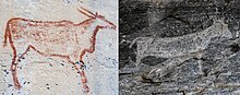
The white-coloured rock art at Tsodilo is associated with the Bantu people. White Paintings Rock Shelter is located on Male Hill depicts animals, both domestic and wild, as well as human-like figures. The human figures are usually painted with their hands on their hips. A handful of them is on horseback, suggesting that these were painted no earlier than the mid-1800s, when horses were first introduced to the area.
Red Paintings. Red rock art is found all over the site. and are attributed to the San people.

Depression Rock Shelter Site. Depressions ground into the walls plus red paintings of cattle and geometrics. 30,000 years old.
Metallurgy. Divuyu and Nqoma have Early Iron Age metal artifacts – jewelry and metal tools, all made from iron and/or copper – bangles, beads, chains, earrings, rings, and pendants, while tools included chisels, projectiles and arrowheads, and even blades.
Spiritual significance. San peoples believe the hills are a resting place for the spirits of the deceased and that these spirits will cause misfortune and bad luck if anyone hunts or causes death near the hills. The local San people believe Tsodilo is the birthplace of all life, art there is made by the descendants of the first people. A natural water spring at Tsodilo, near the Female Hill, is used as both a water collection site and a ritual site. It is seen as sacred, and used by countless peoples to cleanse, heal, and protect.
Turn right to the campsite to register and pay 50 R. Drive through the gate and drive about 5 km on a fair track to the headquarters. Guide mandatory (and necessary as one would not find the sites). Four trails but most of the art is on the Rhino Trail (120 R), a circle route that returns by climbing stairs to cross over the ridge.
The other three trails are White, Cliff and the Hill, all 175 R and longer.
The art is quite ordinary as it is finger painting. Most of the animals are eland but also giraffes, rhinos and cattle. A hunting scene. A modern penguin and whale. They are spread out over the 1.5-hour trail.
It is certainly not worth 600 km of driving. Thankfully it was fast. Everyone said that this was a potholed mess of a road. The broken shoulders when passing are the major problem. Gas is available at Gumare, halfway. It was. a fast drive back to Sehithwa and then I continued on for another 180 km to Ghanzi, an uninspiring city.
The biggest hazard on Botswana roads is all the free-range cattle, donkeys, goats and some horses in the ditches. They seem to have a policy of keeping the grass short along the highways with animals, not a bad idea.
I had a t-bone steak at the Sahara, a very unusual meal for me.
ON Plot 19, a very nice, but expensive ($58) about 5 km out of town in the country.
Day 4 Mon June 5
I was up very early to leave for the 650 km drive to Gaborone, a long drive except here as able to go very fast. This was also a big highway with shoulders and no potholes.
Gcwihaba Caves Tentative WHS (27/05/2010). In the northwest corner of Botswana are 6 low-lying dolomite hills (Aha hills) that straddle the Botswana/Namibia border just north of the village Xai-Xai. Some 35km east of the village. 19km southwest are the 3 Koanaka hills, The Gcwihaba Caves present for 2 million years. Two large cavernous entrances, bats, and windblown sand at least 7m deep.
The cave’s most important feature is the limited air exchange with the surrounding atmosphere as it was more or less totally sealed off from the outside world until researchers entered it for the first time in October 1992. Rich in stalactites and stalagmites, helictites, and soda straws The cave has been resealed after each visit to safeguard the interior air composition.
Massive stalactites, stalagmites, dripstones, and columns/pillars as well as an array of spectacular micro-formations of helictites, soda straws, and cave pearls, totally untouched by man, some of which seem to have defied the force of gravity which normally dictates the speleothems to be precipitated in a vertical position. The caves occurring in the three hills of Koanaka, the Bone Cave and the Blue Cave, contain a type of breccia which has very high densities of fossils. This is the richest cave fossil deposit in Botswana and possibly the richest in Southern Africa.
This was 120 km on a dirt road with a turnoff on the way to Tsodilo. It is also temporarily closed.
I didn’t see
Chobe Linyanti System Tentative WHS (27/05/2010). Comprises the Linyanti River in the north and the Chobe National Park in northwest Botswana with one of the largest game concentrations on the African continent. 11,700 square km. Four distinctly different ecosystems. The Serondela area (or Chobe riverfront) – lush plains and dense teak forests. The Chobe River flows along the northeastern border of the park. The Savuti Marsh is fed by the erratic Savuti channel, one may see dry grassland, hundreds of dead trees along the channel banks, extensive savannas, and rolling grasslands. In the dry season, see warthogs, kudus, impalas, zebras, wildebeests, and elephants. Rain seasons packs of lions, hyenas, zebras or more rarely cheetahs and annual migration of zebras and predators.
The Linyanti Marsh, riverine woodlands, open woodlands as well as lagoons, and flood plains with many lions, leopards, wild dogs, roan antelopes, sable antelopes, hippopotamuses above all enormous herds of elephants. The rare red lechwe, sitatunga and crocodile also occur in the area as well as the rich birdlife.
Finally a hot and dry hinterland, mainly occupied by the Nogatsaa grass/woodland lie between Linyanti and Savuti marshes. The area retains water well into the harsh dry season and thus attracts a profusion of game between August and October and is particularly good for viewing the rare and majestic eland antelope.
The Chobe National Park is probably known for its spectacular elephant population of over 50 000 today which is the highest elephant concentration in Africa. Elephants living here are Kalahari elephants, the largest in size of all known elephant populations.
One of the world’s last true remaining wilderness areas. Intact, least visited in the most pristine corners of Botswana. The Chobe National Park has an amazing variety of habitats, ranging from floodplains, baobab, and mopane trees and acacia woodlands, to verdant flood grasslands and thickets bordering the Chobe River. This amazing variety of habitats is home to huge herds of elephant, buffalo, and Burchell’s zebra and high densities of predators such as Lion, Leopard, Spotted hyena, and Cheetah; unusual antelope species like Roan and Sable, Puku, Tsessebe, Eland, Red Lechwe, Waterbuck, and the rare Chobe Bushbuck. The habitats are also home to about 440 species of birds.
Chobe National Park and/ or Okavango Delta? Malaria area. Campsites inside the national parks need bookings well in advance usually, but last minute in May at the booking agencies at Kasane and/or Maun. Campsites outside the parks – call a day or two ahead.
=============================================================
BOTSWANA – KALAHARI (Ghanzi, Kgalagadi and Southern District)
Kgalagadi Transfrontier Park. Bookings well ahead, South African reservations necessary. Camps on the Botswana side (Rooiputs, Polentswa, Mabuasehube area) are often fully booked throughout the year, a year ahead. Enquire at a booking agency if they can arrange something.
For bookings try Bwana Tucke Tucke (bwana.de) agency from Windhoek. Botswana Footprint
=============================================================
Return to Botswana Southeast
GABORONE (pop 247,000; metro 422,000) is the capital and largest city of Botswana with about 10% of the total population of Botswana.
Gaborone is situated between Kgale Hill and Oodi Hill, near the confluence of the Notwane River and Segoditshane River in the south-eastern corner of Botswana, 15 kilometres (9.3 mi) from the South African border. The city is served by the Sir Seretse Khama International Airport. Locals often refer to the city as GC or Motse-Mshate.
The city of Gaborone is named after Chief Gaborone of the Tlokwa tribe, who once controlled land nearby.[16] Because it had no tribal affiliation and was close to fresh water, the city was planned to be the capital in the mid-1960s when the Bechuanaland Protectorate became an independent nation. The centre of the city is a long strip of commercial businesses, called “Main Mall” with a semicircle-shaped area of government offices to its east. Gaborone was once one of the fastest-growing cities in the world, and this has created problems with housing and illegal settlements. The city has also dealt with conflicts spilling into the country from Zimbabwe and South Africa during the 1980s.
I saw all the things below but forgot to do the write-up and now forget the details
Gaborone Center Office Buildings. Architectural Delights:
Christ the King Cathedral.
Iskcon Botswana Temple
Sir Seretse Khama Statue
Three Dikgosi (Monument)
National Botanical Garden
==============================================================
GENERAL
GET IN
By plane. Botswana’s main airport is Sir Seretse Khama in Gaborone. Most flights arriving in Botswana are from Johannesburg in South Africa, but routes from Cape Town, Harare, and Nairobi are also available. Maun also has a limited number of international flights (Cape Town, Windhoek). The distance between Gaborone and Maun is more than 1,000km. Maun is very much a tourist attraction spot.
By train. Trains to/from South Africa have been withdrawn since 1999. A rail link from from Francistown Bulawayo, Zimbabwe was started in June 2006.
By car. There are several entry points by road to Botswana: In the south at Gaborone, providing access from Johannesburg; in the west providing access from Namibia; the north providing access from Namibia, Zambia and Zimbabwe; and at Francistown in the east, providing access from Harare. All road access is good and the primary roads within Botswana are paved and well-maintained.
Coming from Namibia, you can either go north to Maun, or south along the Trans-Kalahari Highway to Lobatse.
By bus. There is a regular bus service from Johannesburg to Gaborone, which takes six hours. There is also service from Windhoek, Namibia via the Caprivi Strip which will drop you in Chobe National Park, in northern Botswana. There is also bus service from Victoria Falls in Zimbabwe. See Intercape Mainliner for information on service from Namibia and Zimbabwe.
GET AROUND. Very few locals know street names and addresses, and you are likely to have to get directions in terms of landmarks. Botswana doesn’t have a postal delivery system to addresses (just to centralized mail collection points), so even when streets are well-marked, the names may be unfamiliar to residents.
Through a combination of coaches and combies, you can get anywhere in Botswana without any trouble, though public transport is spotty away from big cities and major axes hitchhiking is popular and very easy. However, hitchhiking should only be done in desperate circumstances, as Botswana driving is often very erratic and it can be a harrowing experience to have a stranger drive you somewhere. It is advisable to arrive at the bus station quite early, as the busses do fill up quickly, and it is not uncommon to spend several hours standing in the aisle waiting for a seat to free up (remember to bring water, as the buses are often not air-conditioned).
Online maps for Botswana seem to have errors and omissions. Google is particularly worrisome in that it includes tracks that are fences, or are incomplete (eg the bridges haven’t been built) – for example, if you plot the route from Gaborone to Maun it will suggest you drive via the Central Kalagadi Games Reserve fence, hmmm. Untarred roads present the most uncertainty for the driver, a good option is to look on Google Earth and measure the width of the track, if it is 3 metres wide then it is likely to be a sandy track where you won’t get above 20 kph. If it is 15 metres wide it’ll be a graded gravel road where you may get up to 100kph.
A new system called PlotFind (plotfind.co.bw) was developed for Botswana. It currently contains the addresses (plot numbers) of locations in Gaborone. This system is the best solution for online maps in Gaborone
By car. The roads are paved and well maintained, so travel by car is also not a problem, provided that one keeps a close eye out for the cows, donkeys and goats that spend much time in the middle of the road.
The Trans-Kalahari Highway is an old cattle route, now newly paved and easiy drivable with a 2-wheel drive. It runs from Lobatse to Ghanzi in Botswana, making the connection from Windhoek, Namibia to Gaborone, Botswana. It is a long and uneventful drive, but you get a good feel for the Kalahari Desert. Fuel is available in Kang at the Kang Ultra Shop, which also offers a respectable selection of food, overnight chalets, and inexpensive camping.
Be aware that the road from Maun to Kasane (through Chobe National Park) is an unpaved sandy track, even though some maps show it as a proper road. You need a 4×4 for this route. Going via Nata to/from Kasane/ Maun is much quicker and easier.
Buying a car. Botswana isn’t a bad place to buy a vehicle for a multi-month-long trip around southern Africa, which you can then sell at the end. Botswana is considerably cheaper than South Africa and Gaborone is swamped with second-hand Japanese and UK imports. The paperwork is not too daunting and the dealer can do most of it for you. Websites like Want a Car can give you a good idea of prices.
Beware of the many corrupt police officers who are posted at checkpoints, as they often try and claim fines of up to Pula 1000,00 for allegedly ignoring a stop sign or other offenses. Be polite, stay calm, and respect their (assumed) authority when being pulled over.
Also, the country is divided by many veterinarian fences, which are set up to break the spread of cattle diseases (foot and mouth and so on). There, you are required to surrender all fresh meat products, drive through a disinfectant pit to clean your tires, and rub your shoes on a disinfectant solution too. Depending on the month and situation, sometimes these posts are not manned, but at times the checks here can be thorough.
By bus. There are many bus companies in Botswana. One of the biggest is Seabalo. From Gaborone, you can travel by bus to any bigger city in Botswana.
By train. Botswana Railways operates Botwana’s railways. The main line goes from Lobatse, near the South African border, via Gaborone to Francistown at the Zimbabwean border. As of March 2016, the trains are running and have been refurbished on the Lobatse – Francistown route.
EAT. Indigenous Botswana cuisine is similar to the rest of southern Africa and offers little to inspire. Beef is taken seriously and can be of exceptional quality. The braai is a popular cuisine.
Drink. Throughout Botswana, tap water is safe to drink (this general advice is taken with care, as it varies considerably depending on the area – so make sure you ask locals and travellers alike before drinking it!). Good fruit juice is hard to find (South African 100% juice blends are the norm) although Spar does a range of good juices. The national beer, St Louis, is often derided by foreigners as being worse than domestic US lagers. Most opt for Namibian or South African imports. Bottle stores are widely found in most places, and even regular, slightly bigger supermarkets are allowed to sell booze.
SLEEP
Most of the accommodation establishments in Botswana are located near the larger towns and cities, but there are also many secluded game lodges tucked away in the wilderness areas. In the towns, it is rare for accommodation to be booked up. For the lodges, it is safer to book your accommodation well in advance before travelling to Botswana. This can be done online or via travel agents that have knowledge of the country. As with many safari destinations booking through an agent in your own country may work out cheaper than booking direct – shop around with different agents to get the best price.
As a rule of thumb P400 (US$50) should get you an acceptable en suite room in most of the towns. In the smaller towns away from the tourist routes quality and prices will be lower.
CONTACT Botswana uses GSM900 and has three mobile operators, Orange, Mascom an MTN offshoot, and BEMobile run by Botswana Telecom. Mascom has the worst reputation for customer service. When topping up try and wait for the end of the month when all three operators offer top-up specials. Coverage is restricted to the towns and highways, out in the bush there is generally nothing.
STAY SAFE
People in Botswana are very friendly and the crime rate is low. There isn’t much to worry about on this front. Nevertheless, crime has been on the rise over the past several years, so always be aware of your surroundings. Basic common sense will keep you safe from the predatory wildlife in rural areas. Botswana happens to be one of the safest countries in Africa, with no civil war, less corruption, human rights, and no natural disasters e.g. earthquakes or tsunamis.
LGBT travelers. The anti-homosexuality law was repealed in June of 2019. Botswana is among the most gay-friendly countries in Africa.
STAY HEALTHY
Botswana’s HIV infection rate, estimated at 24.1%, is the 2nd highest reported in the world. Exercise regular universal precautions when dealing with any bodily fluid and remain aware of this high rate of infection. Take precautions accordingly. Wear rubber gloves when dressing someone else’s cut, even if they are a child.
The northern part of Botswana, including Chobe National Park and the Okavango Delta, is in a malaria zone, so it is advisable to take the relevant precautions. Seek medical advice before travelling to these areas.
Water in urban areas is chlorinated and is drunk from the tap by the local population. Still, short-term visitors with sensitive stomachs may feel more secure drinking bottled water. Outside of urban areas, the water is untreated and straight from the borehole and poses a slightly higher risk to the traveller.
