
Zambia May 7-12, 2023
Zambia is a landlocked country at the crossroads of Central, Southern and East Africa and is typically referred to as being in Southern Africa at its most central point. Its neighbours are the Democratic Republic of the Congo to the north, Tanzania to the northeast, Malawi to the east, Mozambique to the southeast, Zimbabwe and Botswana to the south, Namibia to the southwest, and Angola to the west. The capital city is Lusaka, located in the south-central part. The population of around 20.1 million (2023) is concentrated mainly around Lusaka in the south and the Copperbelt Province to the north, the core economic hubs of the country.
The region was affected by the Bantu expansion of the 13th century. Following the arrival of European explorers in the 18th century, the British colonised the region into the British protectorates of Barotseland-North-Western Rhodesia and North-Eastern Rhodesia comprising 73 tribes, towards the end of the 19th century. These were merged in 1911 to form Northern Rhodesia. For most of the colonial period, Zambia was governed by an administration appointed from London with the advice of the British South Africa Company. On 24 October 1964, Zambia became independent of the United Kingdom and prime minister Kenneth Kaunda became the inaugural president. From 1972 to 1991 Zambia was a one-party state with the United National Independence Party as the sole legal political party under the motto “One Zambia, One Nation” coined by Kaunda. Kaunda was succeeded by Frederick Chiluba of the social-democratic Movement for Multi-Party Democracy in 1991, beginning a period of government decentralisation.
Zambia contains minerals, wildlife, forestry, freshwater and arable land. In 2010, the World Bank named Zambia one of the world’s fastest economically reformed countries.
It is located on the plateau of Central Africa, between 1,000 and 1,600 metres (3,300 and 5,200 ft) above sea level. The average elevation of 1,200 metres (3,900 ft) gives the land a generally moderate climate.
Zambezi flows through the country in the west and then forms its southern border with Namibia, Botswana and Zimbabwe. Its source is in Zambia but it diverts into Angola, and a number of its tributaries rise in Angola’s central highlands.
Located in the southwest corner of the country, subsequently flowing into Lake Kariba. The Zambezi valley, running along the southern border, is both deep and wide. From Lake Kariba going east, it is formed by grabens and like the Luangwa, Mweru-Luapula, Mweru-wa-Ntipa and Lake Tanganyika valleys, is a rift valley.
Capital. Lusaka 15°25′S 28°17′E
Official languages. English
Ethic groups. 19.0% Bemba, 13.6% Tonga, 7.5% Tumbuka, 6.0% Chewa, 5.7% Lozi, 5.3% Nsenga, 3.0% Ngoni, 3.1% Lala, 3.9% Kaonde, 2.8% Namwanga, 2.6% Lunda (Northern), 2.5% Mambwe, 2.2% Luvale, 2.4% Lamba and 15 others. 5.4% other ethnics.
Religion. Christianity (official)
Area. 752,617 km2 (290,587 sq mi) (38th). Water 1%
Population. 19,610,769 (63rd). Density 26.1/km2 (67.6/sq mi)
GDP (PPP). $76.325 billion (102nd). Per capita $3,803 (158th)
GDP (Nominal). ![]()
![]() $27.02 billion (112nd). $1,348 (160th)
$27.02 billion (112nd). $1,348 (160th)
Gini. 57.1 high
HDI. 0.565 medium · 154th
Driving side. Left
Calling Code. +260
Electric plug. 3-prong British

Visa. A visa is no longer required for Canadians or Americans.
Most Western visitors can get visas on arrival. Current visa prices are US$50 for a single-entry and US$80 for a multiple-entry visa for all nationalities and is valid for 3 months.
Lusaka Airport Customs and Immigration is unprepared to deal with tourists.
Several other tourists had to supply their accommodation in Zambia to get their visa but I was not asked for it (which was good as I didn’t have anything – there was no accommodation in Kapiri.
Kazangulu border post between Botswana and Zambia – avoid it at all costs…..you are either going to pay a bribe, or be screwed around for hours by their so-called Interpol Police ….. enter Zimbabwe from Kasane and go to Vic falls and then enter Zambia through Victoria Falls
Money. Zambia Kwacha (ZMK), 1 US$ = 17,925 ZMK; 1 € = 19,768 ZMK; 1CA$ = 13,193 ZMK. When coming on the train from Tanzania, the currency on the train changes from Tsh to Kwacha. Money changers enter the train at the border and exchange at a 20% markup.
Changing your money to Kwacha is reasonably easy in the tourist centres of Lusaka Levy Shopping centre has two money changers) and Livingstone and at your border entry. Most major banks will change money and there are various local bureaux de change. As with every country avoid road side money changers.
Tanzanian Shillings. Note that this is not recognized as a tradeable currency and cannot be exchanged at typical money currency exchanges or banks. The only place to change is with money changers at the Intercity Bus terminal. I had 27,000 Tsh and was first offered 1,650 ZK but then got 1,750 ZK or a 16% deduction, but that was better than nothing.
US Dollar. If you bring US$ only the “big heads” (new notes) are accepted, $50 and $100 notes are the best as smaller nominations get 5-10% less. One-dollar bills are useful in Zimbabwe to pay for small items there.
Euros. Changing Euros is difficult and gets a very poor rate (25% less than the market rate!). Finance Bank, Arcades shopping Centre Lusaka accept Euros at a good rate and without commission charge. Rates can change overnight, fluctuations of 3-5% per day are common.
The British Pound is easy to change and fluctuates against the Kwacha less than the other major currencies.
ATMs may be found in major cities, but you should not depend on them to be functional. Most of the ATMs accept only VISA. Other international credit cards (like MASTERCARD and AMEX) are generally a problem except with First National Bank (FNB), Barclays Bank and Standard Chartered Bank. Most, if not all supermarkets and big restaurants accept debit or credit cards. Surcharges don’t apply in Zambia and ATMs only dispense local currency.
Credit cards. You should not depend on credit to get around the country. Visa is the card of choice. Mastercard will not work in a Visa ATM or Visa card swipe machine. Barclays and Stanbic are the only banks that operate MasterCard.
Climate. The climate of Zambia is tropical, modified by elevation.
There are two main seasons, the rainy season (November to April), and the dry season (May/June to October/November), corresponding to winter. Average monthly temperatures remain above 20 °C (68 °F) over most of the country for eight or more months of the year.
SIM Airtel or MTN in Zambia. I got an MTN SIM in Lusaka at the Intercity Bus terminal for 70 ZK with only 2 GB of data.
Zambia parks. Zambia offers travellers some of the world’s best safari opportunities, a glimpse into “real Africa,” and Victoria Falls, one of the World’s Seven Natural Wonders and a UNESCO World Heritage Site. They are not cheap either $40 per car and $25 entrance, camping inside $25, a night drive even on the same day with a safari company entrance fee, not hiring of safari driver $20 more between 6 and 8 pm. Zambia also charges tolls, kwa20 every time, but the roads are horrific.
Zambia is making a name for itself as a must-do safari destination. Organized safaris are the way to go in Zambia. Self-driving is an option but is only for the fully self-sufficient. Zambia is home to some of Africa’s greatest national parks. Lower Zambezi, South Luangwa and the frankly huge (the world’s second biggest NP) Kafue are the main ones, but North Luangwa and the virtually inaccessible Luiwa Plains are worth a mention. Safaris are through various operators, many being very expensive, but good value options are available and it’s best to use a local established operator such as The River Safari Company, South Luangwa Safaris.
Dar Es Salaam to Kapiri Mposhi, Zambia by train. The Mukuba Express Train, every Tuesday from New Kapiri Mposhi to Dar es Salaam and every Friday from Dar es Salaam to New Kapiri-Mposhi, departing from New Kapiri-Mposhi and Dar es Salaam at 16:00 CAT and 15:50 EAT, respectively. The Mukuba is named after Zambia’s top mineral export, copper, for which the country remains one of the top producers in the world. It takes approximately 46 hours to travel between Dar es Salaam and New Kapiri Mposhi.
Passengers have the rare treat of viewing a variety of game along the way. When passing though the tunnels, and crossing rivers and gorges, passengers have a chance to appreciate the awesome and inspirational engineering works of the Chinese, who constructed the rail line between 1970 and 1975. It now uses 2016 Chinese-built cars.
The train passed through the Selous Game Reserve, but unfortunately at night.
Timetable: Departs Dar es Salam @ 15:50 Friday, Mbeya 13:08 Saturday, Tunduma (border) 17:02, Nakondé 16:22, Kapiri Mposhi (New) 09:26 Sunday. Stops last about 15 minutes.
Cost: 116,200 Tsh in 1st class sleeper, 95,000 Tsh in 2nd class sleeper, 83,400? Tsh in a 2nd class seat, 77,600? Tanzanian shillings in a 3rd class seat.
Buying tickets. You cannot buy tickets online, you should buy them at the station (this is what I ended up doing but cost 15,000 Tsh for a boda there and back) or by phone (never answered). Call the Dar Es Salaam ticket office at +255 22 26 2191 for westbound journeys, or call the station master at Dar at +255 78 7099 064, reserve by phone and collect and pay for tickets when you get there. If these don’t work, these numbers for the booking office have also been reported as working: +255 767099064 or +255 787099064. Additional numbers to try +255 715469239, +255 784345492, +255 754260988 or +255 784454510. No matter how many times you try to call the phone numbers, they never get answered.
Tickets can also be bought through Sykes Travel Agents via email.
Tips: There aren’t many shops around the Tazara station, so if you need supplies for the journey, buy them in the town centre first. Also, the few ‘hotels’ in Kapiri Mposhi are along the main drag, there’s nothing near the Tazara station.
To sit in the dining car, one must buy food. The next car is a “bar” car with loud music and guys getting drunk. Next are four couches with small tables facing each other. Next is a large car with good seats facing each other with a small table where I ended up spending most of my time.
The scenery was varied (Tanzanian highlands were best), restaurant car food was basic but filling, and beer. Good place to meet locals and other travellers. Bunks are fairly comfortable. Make sure you have enough cash for the journey. Once across the border in Zambia your shillings are useless – the restaurant and bar will only take kwacha and vice versa if travelling the other direction. Money changers will embark as you approach the border of Tunduma/Nakonde – he’ll take you for about 20%.
Buses outside the station take people to Lusaka or wherever their next destination was. Bring a blanket or sleeping bag, bottled water, good books, a torch or a headlamp.
I was in a second-class sleeper with five nice black guys. There is not a lot of room to store stuff and most of mine is under one of the lower bunks. I went down to the dining car hoping to hang out there until it was time to sleep. But you can only sit here when you order food. A second dining car (the bar?) is next door but has loud music and guys drinking. I had a very soft avocado, tomato and onion. The train didn’t start to move until 15:15.
The only legal place to smoke on the train was at the very back where there is an open window. It is a long nine-car walk from the chair area where I spent most of my time.
I moved down from the dining room tables to a small area with 4 couches and tables. The two English left because one didn’t like the locals staring at her. My chips never arrived. I moved down to the next car with good seats facing each other and a half table. It was quite comfortable when all the windows are opened. I read more of “The Vital Question: Energy, Evolution, and the Origins of Complex Life” by Nick Lane, a fascinating and complex book to read, that I think I would have difficulty reading without a good medical background.
I had chips for dinner and talked briefly with the German physician and for a long time to a native Tanzanian going to Zambia where he has a business. He was a very smart guy with good English learned when he attended university in Boston. As expected he was quite religious. Things that I ascribed to luck, he said were “blessings from God”.
I had a good sleep using my silk sleep sheet and sleeping bag. The window was wide open and the noisy fan on.
Sitting in the “couch” area before bed, I talked for quite a while to one of the guys in my room who was a musician. There were women there, and they repetitively asked why I didn’t know Swahili. One, an enormous, very black woman wanted to have a chocolate baby with me.
The terrain we passed through as we neared Selous NP was a flat savanna with trees. With dusk approaching, I looked out the window for a long time hoping to see some wildlife but didn’t. Virtually uninhabited, we had a brief stop at a large blue metal-clad building with some large drilling rigs, then saw nothing until Mwaya where we stopped for over half an hour.
ON train.
Day 1 Sun May 7
I finally got up at 07:30 and had breakfast of cereal, over-ripe bananas, cashews and coffee that I had brought along. We stopped at 8:45 at Makambako (my second time here) for over 45 minutes. There was an opportunity to buy food and have a smoke off the train.
I had guacamole for lunch (the avocado was so ripe and soft, I expected it to be black, but this variety remained entirely green, onion, tomato, and lime juice on bread from the kitchen). I hope to run out of all the food I brought by Zambia.
After a long stop in Mbele Tanzania, the train passed through fields of corn and sunflowers and climbed over a pass to cross the Tanzania/Zambia border at Tunduma/Nakonde.
ZAMBIA LUAPULA, NORTHERN AND MUCHINGA (Kasama)B
Tanzania/Zambia Border
We crossed the Tanzania/Zambia border at Tunduma/Nakonde at 9 pm. We were told nothing by the train people. The train from Zambia was also in the station and we had to climb across that train to get to Tanzania immigration. There was a large dark hall with nobody present except all the people crossing from Zambia. I eventually got into the exit line, filled out a form and got my exit stamp.
I was then at the mercy of the money changers. I had 19,500 Tsh worth officially 149 ZMW and got 140. I was then told that the ATM in Kapiri Mposhi was 15 km from the train station so changed US$50 for 850 ZMW (the official rate of 900 ZMW). Zambian immigration was 2 km away and we boarded the train again.
At Zambian immigration, it was very easy and free (Canadians are visa-free). The officer even put the stamp where I wanted.
I was offered a registered SIM but under someone else’s name so refused.
ON train.
Day 2 Mon May 8
ZAMBIA – LUAPULA, NORTHERN and MUCHINGA (Kasama)
Borders: Congo Democratic Republic-Zambia, Malawi-Zambia, Tanzania-Zambia, Zambia (river)
Zambia is a flat country of grass and bush with sporadic corn fields. We had hour-long stops at Chambesh, Mpika (gold has been discovered north of the town. The government has opened the area to surface miners and the area has had an influx of thousands of miners), and Serinje. I spent the day reading. The train arrived at Kapiri Mjoshi at 9 pm. There was a very nice guy in my train sleeping room from Kapiri Mjoshi who was of great help. With two other guys from the same room, we walked about 1 km from the train station to the main road and turned left about 100 yards to a hotel. He then took us down to the bus station to show it where it was for the next morning.
ON Shikatasha Corporate Hotel, Kapiri. Down a short side lane, the two others shared a twin room and I got a single room for 250 ZK. There was no wifi, water in the sink or hot water for a shower.
I didn’t see
MFUWE
The main settlement of the park, and South Luangwa’s main access point is outside its eastern boundary at Mfuwe, and it has an airport which has flights to Lusaka, the Lower Zambezi and Lilongwe in Malawi.
From Lusaka, you take the road to Chipata (Great Eastern Road) and from that road (well before Chipata) take the junction to Petauke. Once you drive through Petauke you will go off the tarred road on a very fair gravel road. After 60km on this road, you turn left followed by a 120km local rural road to Malama Chiefdom and Mfuwe. Road is not too bad. When you go under the electricity network cables (ZESCO Main Power Lines), you enter the Malama Chiefdom and will be only 15km away from the junction. This junction will lead (via the Malama Chief’s Palace) you either to the Lusangazi Gate of the National Park (left) or onward direction Mfuwe (right). The junction is at a little village.
If you head for Mfuwe, you will find a campsite after 9km along the Luangwa River, called Malama Umoyo Camp. It is 1,5km after the scouts training center. This (basic) campsite is located at a stunning location overlooking the Luangwa River and a dry lagoon, most of the time filled with wildlife.
From Malama Umoyo Camp it is 42km (2,5 hours drive) to Mfuwe. Mfuwe is a local but bigger than normal village. In the Mfuwe area, you will find a lot of lodges, but also a good campsite, Croc Valley Camp. If you arrive from Malama and hit the tarred road, you turn left after 3km and after a few hundred meters right off the tarred road on to a gravelled road. Signposts will lead you further to Croc Valley Camp. When visiting Mfuwe, and you prefer a lodge for a good sleep, dinner and a warm shower: Thornicroft Lodge en Croc Valley are both recommendable (good value for money). From here it is only a 5-minute drive to the main gate of the South Luangwa National Park.
SOUTH LUANGWA NP. One of Africa’s greatest safari destinations, it is in eastern Zambia, the southernmost of three national parks in the valley of the Luangwa River. It is a world-renowned wildlife haven which is known to locals simply as “the South Park”. Concentrations of game along the meandering Luangwa River and its lagoons are amongst the most intense in Africa. The river teems with hippos and crocodiles and provides a lifeline for one of the greatest diversities of habitat and wildlife, supporting more than 60 species of mammals and over 400 species of birds. It marks the end of the Great Rift Valley. South Luangwa National Park (SLNP), can be visited with your private car.
It supports large populations of Thornicroft’s giraffe, and herds of elephants and Cape buffaloes often several hundred strong. It is one of the best-known national parks in Africa for walking safaris. Founded as a game reserve in 1938, it became a national park in 1972 and now covers 9,050 km2.
The Park is unfenced and bordered to the west by a steep escarpment and to the east by the Luangwa River. The Luangwa Valley lies at the tail end of the Great African Rift Valley system, which extends 4,000 km all the way from the Red Sea down to the Pungwe River mouth in Mozambique. The Muchinga Escarpment in Muchinga and Central Provinces forms the park’s western or north-western boundary. It slopes down from there to the river, lying mostly on its western bank. The eastern bank of the river is in the Eastern Province, and as access to the park is only from that side, it is usually thought of as being wholly in the Eastern Province.
The park spans two eco-regions, both of them woodland savannah, distinguished by the dominant tree: Southern Miombo woodlands cover the higher slopes of the valley, while Zambezian and Mopane woodlands cover the bottom of the valley. The Mopane tree tolerates the higher temperatures and lower rainfall found at lower elevations than miombo trees which are found on the higher plateau. Within these woodland savannahs are larger patches of grassland so that grazers such as zebra and leaf browsers such as giraffes are found in profusion in the same areas. Patches of flooded grassland habitats (floodplains) are found close to the river, on which hippopotamus graze at night. Their dung released into the river fertilises its waters and sustains the fish population which in turn sustains the crocodiles.
The Luangwa valley, continued to the west by the Lunsemfwa River valley, contains some varieties of animals such as Cookson’s wildebeest and Crawshay’s zebra which are endemic or near-endemic to the valley. It also represents something of a natural barrier to human migration and transport, no roads cross it and this has helped conserve its wildlife.
Although this park is generally well-protected from poaching, its black rhinos were extirpated by 1987, and the elephant population has been under serious pressure at times.
South Luangwa is also accessible by 4×4 vehicles.
Undoubtedly the best way to experience South Luangwa is to be in your own (safari) vehicle. A Luangwa self-drive exploration and guided service when needed, gives you the freedom to plan for your own interests and move at your own pace plus adds the thrill of spotting wildlife at your leisure. Get out in the village and at various community projects and enjoy Zambian life. That’s why you have your “own” vehicle.
Driving. The South Luangwa National Park is surrounded by the so-called GMA’s (Game Management Areas). You will find only limited habitation and you will be able to see an abundance of wildlife, like, lions, leopards, elephants, giraffes, etc. A recommendable tour is from Petauke to Malama, on to Mfuwe and to the Nsefu sector (or the other way around). This route can only be done with a well-equipped 4×4 car. You will see and enjoy to the full, the true rural Africa, the local people and their villages and wildlife.
The entrance fee for the SLNP is USD 25 per person per 24 hours and USD 35 for a private car entering the park. Hours 06:00 to 18:00 hours.
From Mfuwe/Croc Valley Camp you can proceed to the Nsefu sector. Do not forget to fill your fuel tank in Mfuwe. You follow the tarred road to Chipata and the local airport and after about 12km from Mfuwe, you turn left (you will see a signpost and two palm trees). After about 12km you will reach the gate of the National Park. If you are going to camp, then tell at the gate that you are on your way to Zikomo camp. Zikomo Camp is just outside the borders of the park. Right after the gate you turn left and follow the road (about 4 to 5 km) to Zikomo Camp. The Nsefu sector is part of the SNLP and is considered by many as the most beautiful part of the park. After visiting Mfuwe, you can then return to Chipata (about 2 hours drive). Chipata is the capital of the Eastern Province and a good place to buy supplies and refuel. There are two supermarkets and lots of shops.
Alternative route: From Mfuwe there is the possibility to go right through the park to the North. This is an adventurous road. Do NOT drive this road when it is wet/raining! When you pass the northern gate, you will reach the escarpment and you have to drive up a very steep road. It can be done by good 4×4 drivers, but do it slowly. Once out of the Luangwa Valley, you will have a stunning view of the valley.
You then can proceed to Mpika. In Mpika you can camp and get new supplies and fuel. From Mpika you can visit Kasanka NP (in November you will be able to see the daily migrations of millions of bats) or you can go up north. Recommended is to visit Shiwa Ngandu. A beautiful mansion built by an eccentric British gentleman (Stewart Gore Brown) 100 years ago in the middle of nowhere. Camping you can be near the hot water springs. The water is lovely and relaxing for at least a half-hour dip. From here you can proceed for example to Tanzania (to Ruaha NP, also a place not to miss).
North Luangwa National Park is only recently open for day trips
Day 3 Tue May 9.
I was up at 04:45, had a cold shower, woke up the guard and made hot water for coffee. I left my luggage at the hotel and then walked down to the bus station. There I met Jerry, a lovely South African missionary. The bus (120 ZK) turned into a private car to Ndola that left at 07:30 for the 2-hour drive. For 1oo ZK, he drove me around Ndola to the Tentative WHS and then back to the main road.
ZAMBIA – NORTHWESTERN AND COPPERBELT (Ndola, Kitwe, Solwezi)
Borders: Angola-Zambia, Congo Democratic Republic-Zambia
NDOLA (pop 475,194 2010) is the third largest city in Zambia. It is the industrial and commercial center of the Copperbelt, Zambia’s copper-mining region, and capital of Copperbelt Province. It lies just 10 kilometres (6.2 mi) from the border with DR Congo. It is also home to Zambia’s first modern stadium, the Levy Mwanawasa Stadium.
Dag Hammarskjold Memorial (Crash site) Tentative WHS (11/06/1997) marks the place of the plane crash in which Dag Hammarskjöld, the second and then-sitting Secretary-General of the United Nations was killed on 17 September 1961, while on a mission to the Léopoldville Congo Republic (now the Democratic Republic of the Congo). The site is located 10 km from Ndola,
The Dag Hammarskjöld Crash Site was declared a national monument under notice number 14 of 1970 as a historical landmark. In 1964 the Dag Hammarskjöld Foundation Committee was formed to ensure that the memory of this world statesman lives forever in the country where he met his tragedy. At the Crash site, a memorial garden was established with a cairn at the centre and a lawn around it with a belt of shrubs and trees on the outer circle. A museum was constructed and officially opened at the site in 1981. The museum exhibits some remains of the tragic accident. The museum is also used for collecting materials and books on the life of Dag Hammarskjöld and the role of the United Nations.
Göran Björkdahl interviewed several witnesses around the crash site in the 2000s and studied archival documents related to the Katanga crisis. He wrote in 2011 that he believed Dag Hammarskjöld’s death was a murder committed in part to benefit mining companies such as Union Minière.
It is about a 20 km drive from central Ndola and 7.5 km off the highway. Enter to confront the large circle of lawn and shrubs with a central stone plinth holding a globe in a hand that is the actual plane wreck site. There is a stone building with several dioramas about the Hammarskjold, the crash and 12 theories of causation. $15
Copperbelt Museum showcases the local industry with billboards with displays on Zambia’s mining history, gemstones and the processing of copper. Upstairs are artifacts used in witchcraft, personal ornaments, smoking and snuffing paraphernalia, and musical instruments such as talking drums. 100 ZK
Catholic Church. A small single story nondescript church.
I saw the museum and church, had a burger at Steers walked the short block to the bus station and paid 200 ZK for the 115 km bus ride back to Kapiri. There I ran back to the hotel to pick up my luggage and just made it back to the bus to continue onto Lusaka for another 50 ZK.
==============================================================
ZAMBIA – LUSAKA, CENTRAL, EASTERN. (Kabwe, Chipata)
Borders: Congo Democratic Republic-Zambia, Malawi-Zambia, Zambia-Zimbabwe
I arrived at 19:00, got an Airtel SIM (70 ZK), ate at the Hungry Lion and caught a Yango taxi to my hostel
ON Lusaka Backpackers – $10/night for a dorm room. No mosquitoes at this time of the year. Kitchen and restaurant.
Day 4 Wed May 10
LUSAKA (pop 3.3 million, urban 2.5 million) is the capital and largest city of Zambia. It is one of the fastest-developing cities in southern Africa. Lusaka is in the southern part of the central plateau at an elevation of about 1,279 metres (4,196 ft).
The earliest evidence of settlement in the area dates to the 6th century AD, with the first known settlement in the 11th century. It was then home to the Lenje and Soli peoples from the 17th or 18th century. The founding of the modern city occurred in 1905 when it lay in the British protectorate of Northern Rhodesia, which was controlled by the British South African Company (BSAC). The BSAC built a railway linking their mines in the Copperbelt to Cape Town and Lusaka was designated as a water stop on that line. White Afrikaner farmers then settled in the area and expanded Lusaka into a regional trading centre, taking over its administration. In 1929, five years after taking over control of Northern Rhodesia from the BSAC, the British colonial administration decided to move its capital from Livingstone to a more central location, and Lusaka was chosen.
Lusaka lost some of its status to Salisbury (now Harare in Zimbabwe) when the latter became the capital of the merged Federation of Rhodesia and Nyasaland in 1953, but regained it when it was named the capital of newly independent Zambia in 1964. A large-scale building programme in the city followed, including government buildings, the University of Zambia and a new airport. Wealthy suburbs in Lusaka include Woodlands, Ibex Hill and Rhodes Park. Large-scale migration of people from other areas of Zambia occurred both before and after independence, and a lack of sufficient formal housing led to the emergence of numerous unplanned shanty towns on the city’s western and southern fringes.
Airports: Lusaka (LUN)
I had my usual walk about.
Society House tower. In the NM Architectural Delights series, it is a 20-storey multipurpose development located on Cairo Road. It has the Hilton Garden Inn. What was once Zambia’s tallest building has been infused with copper in its design. What makes the building remarkable is the fact that it was damaged by fire in the 1990s and was derelict for over a decade bringing it back to life in 2017. In addition to the hotel and restaurants, Society House also comprises of office space, multilevel car parking space and restaurants. The building’s total footprint is around 60,000 sqm.
Soweto Market. A long 2.5 km walk, this is a typical general market with everything from produce to clothes.
Comesa Market. In a three-story building, it is primarily bedding and clothes with the occasional liquor store.
Masjid E Umar al-Farooq Mosque. Enter down a side lane parallel to Cairo Road. Single hexagonal minaret with a lot of wood in the prayer hall and coloured windows.
Freedom Statue. Dedicated to The Freedom Fighters, it was erected in 1974 on the 10th anniversary of independence. It is on a concrete plinth (with bas reliefs on two sides) and a bronze man breaking loose from chains.
Lusaka National Museum. The first floor has art and a series of huge photographs of Zambia. On the second floor is history from the Stone Age to modern times with a lot on Kaunda. Exhibits include tribal life and ethnography. 91 ZK (gave 100 and had no change). Seen by guided tour.
Jaame Mosque. A cream brick exterior with a hexagonal single minaret, the inside has nice marble columns and mihrab/minbar. I washed my feet in the nice ablution area.
Anglican Cathedral of the Holy Cross. Built in 1957-62, it is reinforced concrete with lovely coloured glass walls.
Cathedral of the Child Jesus is a Catholic Church near the Pope Square and Lusaka Airport. It was dedicated in 2006. Pope John Paul II celebrated a Mass at the site when it was just a clear field in 1989, and blessed the first stone of the building.
Arcades Shopping Centre offers a wide variety of clothing stores, jewellery stores, eateries and entertainment with the Lusaka Royal Casino and Ster Kinekor Cinema complex with its five cinemas plus a Spar supermarket,
The Centre is also the site of the Pakati Market held every Sunday, but some of the crafts and carvings come from the DRC, Kenya and Tanzania and are, therefore, not authentic Zambia crafts.
ON Lusaka Backpackers. Even hot showers. I met two very unusual travellers and have decided to start a post about unusual travellers.
==============================================================
Day 5 Thur May 11
I was up early, had a hot shower, my own BF and walked down to Lusaka Intercity Bus Terminal. I arrived at 08:30 (too late). This bus station is chaos with too many people wanting to help. I got hustled to an MB Sprinter van holding 22 people. I was told it would leave at 10, irrelevant of several passengers. It never did get enough passengers (I had a front seat) and had to join another Sprinter MCK BLB234, getting the worst seat at the very back with no leg room. The bus was full and I was wedged in between huge nylon sacks. I moved up to the next row with a single seat on one side but it had the wheel well. I sat diagonally and could stretch my right leg out but my left was tightly flexed. A man with a ten and eight-year-old got on to be wedged into the back row. Guys were sitting on all the huge bags in the aisle. We finally left at 12:45 for the 7-hour, 475 km drive. I was able to tolerate the seating by reading my Kindle most of the way. We finally arrived at 20:45 for an 8-hour mess.
I was let out 200 from the hostel and had a burger for dinner.
ON Cafe Zambezi 180 ZK. A front restaurant with a complete selection of rooms at the back. I stayed in a dorm room with no one else in it.
Day 6 Fri May 12
ZAMBIA – SOUTHERN and WESTERN (Livingstone, Mongu)
Borders: Angola-Zambia, Namibia-Zambia, Zambia (river), Zambia-Zimbabwe
LIVINGSTON. (pop 135,000) Until 1935, it served as the capital city of Zambia (then Northern Rhodesia). Lying 10 km (6.2 mi) to the north of the Zambezi River, it is a tourism attraction center for Victoria Falls and a border town with road and rail connections to Zimbabwe on the other side of the Victoria Falls. A historic British colonial city, its present population was enumerated at 134,349 inhabitants at the 2010 census.[5] It is named after David Livingstone, the Scottish explorer and missionary who was the first European to explore the area.
Airports: Livingstone (LVI)
Livingstone Museum has the usual regional museum features: archaeology, ethnography, natural history, and a lot about David Livingston. 100 ZK.
Railway Museum is dedicated to preserving Zambia’s railway heritage, as well as holding an exhibition on the history of Jews in Zambia.
I left the hostel with Carol Beck, an American from Detroit to see Victoria Falls taking a normal taxi to the border. We saw the Knife Edge Bridge, then crossed through Zambia and Zimbabwe immigration. Zimbabwe wanted accommodation but eventually relented and let me through. US$50
Victoria Falls (Mosi-oa-Tunya “Thundering Smoke”) WHS is a waterfall on the Zambezi River, which provides a habitat for several unique species of plants and animals. It is located on the border between Zambia and Zimbabwe and is one of the world’s largest waterfalls, with a width of 1,708 m (5,604 ft).
Archeological sites and oral history describe a long record of African knowledge of the site. Though known to some European geographers before the 19th century, Scottish missionary David Livingstone identified the falls in 1855 from what is now known as Livingstone Island, one of two land masses in the middle of the river, immediately upstream from the falls near the Zambian shore. He named the English colonial name of Victoria Falls after Queen Victoria. Since the mid-20th century, the site has been an increasingly important source of tourism. Zambia and Zimbabwe both have national parks and tourism infrastructure at the site. Research in the late 2010s found that precipitation variability due to climate change is likely to change the character of the fall.
The nearby national park in Zambia is named Mosi-oa-Tunya, whereas the national park and town on the Zimbabwean shore are both named Victoria Falls.
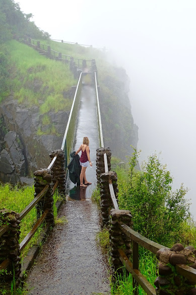
Knife Edge Bridge. This spectacular walk along the Knife Edge of the precipice is the best way to view Victoria Falls from the Zambian side. It can be accessed shortly after the Zambian border post and it is possible to walk across from the Zimbabwean side.
During winter, there is a very good chance that the Eastern Cataract – which you look on to from here – will be dry and no water will be falling over the top. During the rainy season, this is one of the closest points – in horizontal distance – from which you can approach Victoria Falls on either side of the Boiling Pot.
In any season, the view alone down into the bottom of the gorge is worth it and you can see how the present Falls are dying from east to west. Knife’s Edge offers a unique perspective back along Rainbow Falls and you can see Danger Point and the sheer drop below it. The remainder of Victoria Falls is obscured from here, but there is probably no better spot from which to view the huge plume of spray than this overlook.
 ==============================================================
GENERAL
HISTORY
The territory of Northern Rhodesia was administered by John Cecil Rhodes’s British South Africa Company from 1891 until it was formally administered as a British crown colony in 1923. During the 1920s and 1930s, advances in mining spurred development and immigration.
Britain tried to administer Northern Rhodesia in a federation with Nysaland (Malawi) and Southern Rhodesia (Zimbabwe) however this was opposed by Northern Rhodesia which was concerned that the majority of the investment and money would flow to the south. During this period to help build the economy the British built the Kariba Dam on the Zambezi River creating Lake Kariba, one of Africa’s largest lakes and providing hydroelectric power for the area. The British granted self-rule to their colonies in the period after the Second World War and after abandoning the federation idea Northern Rhodesia transferred to self-government.
The name was changed to Zambia upon independence in 1964. In the 1970s, 1980s and 1990s, declining copper prices, one-party democracy under Kenneth Kaunda and a prolonged drought hurt the economy. However, Zambia under Kaunda was a staunch anti-Apartheid supporter, one of the only countries in the region to be so. As such it provided a base for the ANC to operate from, the previous South African President Jacob Zuma was at the time based in Lusaka. This created huge obstacles to Zambia, with South Rhodesia under Ian Smith’s white rule invading and bombing Lusaka and South Africa cutting its economic ties and attempting its own “sanctions” against the Zambians.
Elections in 1991 brought an end to one-party rule, but the subsequent vote in 1996 saw blatant harassment of opposition parties. The election in 2001 was marked by administrative problems with at least two parties filing legal petitions challenging the results.
Zambia transitioned to a proper functioning democracy with the advent of Levy Mwanawasa as President. He led the Movement for Multi-Party Democracy (MMD) to power with a platform of stamping out corruption. Following Mwanawasa’s untimely death in office Zambia went on to the 2011 election and claimed the title of being one of the few African countries to have a sitting President lose an election. The peaceful election was taken as an indicator of how far Zambia had come and is viewed as a model African democracy.This was shown after the handover of power from the MMD to the Patriotic Front (PF) under Michael Sata. Sata would hold onto power until his untimely death in October 2014. Guy Scott served briefly as president until new elections were held on 20 January 2015, in which Edgar Lungu was elected as the sixth President.
ECONOMY
Much of Zambia remains poor, with a GDP per capita of the order of USD1800/year, and the bulk of Zambia’s population lives on subsistence agriculture. The economy continues to revolve around copper; after decades of mismanagement, the industry is now doing better thanks to higher commodity prices and investments made after privatization. Another recent success story has been the rebranding of tourism, driving tourists to the northern side of Victoria Falls and Zambia’s safaris, and the fast growth has come from a low base.
PEOPLE
As can be seen even from the bizarre squashed-peanut shape of the country, Zambia is one of the stranger legacies of colonialism, agglomerating a large number of different tribes (73, according to the official count) and languages (20, plus dialects). Fortunately, with a long history of coexistence, significant migration around the country and similar Bantu-family languages, they all seem to get along pretty well and Zambia has been spared the violent inter-tribal strife that has decimated countries like Rwanda.
The Bemba are the largest group in Zambia, but they still form only about 20% of the population. The Bemba came from the Congo in the 16th century, and while their homelands are in the north and middle of Zambia, many have immigrated to Lusaka and the Copperbelt.
The Chewa, Ngoni and Nsenga tribes, all found in the east of the country, share the Nyanja language and form Zambia’s second-largest grouping with about 15%. The Tonga, Ila and Lenje, known together as the Bantu Botatwe (Three Peoples), are a close runner-up with 15% of the population, concentrated in the west of the country in the Zambezi Valley and the plateaus to the north. The Lozi in the far west (6%) are known for their craftwork, particularly basketry, and for a low-key (non-violent) secessionist movement calling for an independent Barotseland. Other tribes in Zambia’s patchwork include the Lala and Bisa (5%), the Kaonde (3%), the Mambwe and Lungu (3%), the Lunda (3%), the Lamba (2.5%) and the Luvale (2%), and 57 more. Despair not: the differences are not crucial for travellers, and locals will be happy to explain their traditions when needed, notably at festivals.
White Africans of English or Afrikaner descent (1.2%) are also visible, particularly in the more upmarket areas of the major cities.
FESTIVALS
A highlight of any trip to Zambia is a visit to any of the many traditional festivals held throughout the country. Planning ahead can be tough though, as schedules are variable and not all are held yearly. Also, if you do manage to attend, bring along tolerance for heat, dust and crowds (increasingly drunk as the evening wears on) and patience for endless speeches by local functionaries On the plus side, any foreigners attending can usually sneak into the VIP stands, although you may get hassled for photo permits.
Kazanga, Kaoma [Central Western Zambia] (June – August). The Kazanga ceremony is considered Zambia’s oldest traditional ceremony having been celebrated by the Nkoya people for over 500 years. The ceremony celebrates and maintains Nkoya traditions of music, dance and many other ancient practices.
Kuomboka, Lealui/Limulunga (Western Province), around Easter (March-April). The most famous of Zambia’s festivals, this is the ceremonial migration of the Lozi king (litunga) from his dry season abode at Lealui to his wet season palace at Limulunga. Wearing an elaborate Victorian ambassador’s costume, the litunga is taken by a flotilla of barges down the river, with musical accompaniment and, of course, much feasting at the destination.
Ncwala, near Chipata, 24 February. A Ngoni festival to celebrate the first fruit of the season, where the Ngoni chief ceremonially tastes the fruit of the land, then spears a bull and drinks its blood.
Kulamba, near Chipata, August. A Chewa Thanksgiving festival known for its Nyau secret society dancers.
Likumbi Lya Mize (August). This is a popular August festival(The Day of Mize). This ceremony takes place at Mize, the official palace of Senior Chief Ndungu, about seven kilometres west of Zambezi Boma. People of the Luvale tribe gather to celebrate their cultural heritage, bringing displays of all types of handicrafts and spicing the event with traditional singing and dancing while the chief holds the court. Mize is the official palace of Senior Chief Ndungu. The Makishi dancers recreate famous events from Luvale mythology, and local artists display their work.
Livingstone Cultural & Arts Festival This was first held in 1994, this festival brings the traditional rulers from all the provinces of Zambia and visitors are also allowed with the knowledge of the culture in their tribe. This festival captures musicians, artists, poets, and dramatists.
Shimunenga is a ceremony to show devotion to ancestors. The ceremony takes place on a full moon on weekends in September and October. The Ba-lla tribe celebrate this ceremony at Malla on the Kafue Flats.
The Umutomboko ceremony of the Lunda people in Luapula Province is held at Mwansabombwe to depict the coming to Zambia by the Lunda and Luba people from Kola in now Congo DR.The ceremony is held in July and is graced by Mwata Kazembe who dances to commemorate the occasion.
CLIMATE
If you look at a map, Zambia appears to be squarely in the tropics, but thanks to its landlocked and elevated position it does have distinct seasons:
Winter — May to July, coolest 6-12°C day, and as low as 4 or 5°C at night; average maximum 21-26°C. Probably the best time of year to visit Zambia: come early in the dry season for birdwatching or to see Vic Falls at their biggest, or later when the bush has dried up for good game-spotting on safari.
Spring — August to September, mildest. Most traditional festivals are held then.
Dry Summer — October to November. Hottest and driest with maximum to 28-35°C. This is a good time for safaris as wildlife clusters around the few remaining watering holes.
Wet Summer — Late November to March – maximum range 25-30. A lot of rain — sometimes just an hour or two, sometimes for days on end. Great for tropical fruits.
Autumn — Late March to April – maximum 22-28. Harvest season with fresh organic food. Zambia does not allow GMOs.
GET IN
By plane. Zambia’s main international gateway is Lusaka;
KLM from Amsterdam. Emirates from the Middle East. British Airways. Ethiopian, Kenya Airways, Angola Air and Rwanda Air.
Livingstone International Airport has daily direct flights from Johannesburg with the carriers: South African Airways, British Airways and Kulula.
Travellers can also fly to Ndola without connecting through Lusaka on South African Airways from Jo’burg to Ndola. Ndola is the capital of the Copperbelt province.
By train
TAZARA trains run between Kapiri Mposhi, Zambia, and Dar es Salaam, Tanzania,
Bring water. Immigration officials stamp passports as soon as the train crosses the border. If you are riding in a first- or second-class cabin, be very careful when opening your door.
Immediately upon crossing the border, the crew no longer accepts the currency of the country you just exited. Exchange money before the journey — black marketeers along the railroad offer poor exchange rates.
Do not leave valuables near windows, especially at stops.
First class cabins women and men can stay in the same compartment but in 2nd class, they are female and male only.
The last stop in Zambia is in the middle of nowhere, the small town of Kapiri Mposhi. Plenty of minibuses are eager to carry you to Lusaka, for 2-3 hours. The first reasonable town to Lusaka direction from Kapiri is Kabwe (it is rated among 5 most polluted place on earth due to mining!)
Via Zimbabwe/Victoria Falls: trains in Zimbabwe run from Bulawayo to Victoria Falls. You can take a taxi or hike 13 km across the border at the Victoria Falls Bridge to Livingstone station in Zambia and catch a Zambia Railways train to Lusaka and the Copperbelt connecting with the Tazara railway in Kapiri Mposhi.
By car. There are many ways to get into Zambia by car, but the most popular include:
– through Livingstone (in the south) from Zimbabwe
– via the Chirundu Bridge (in the south) from Zimbabwe
– via the Kariba Dam (in the south) from Zimbabwe
– through Chipata (in the east) from Malawi. From Chipata, it is a 20 minutes drive to the Malawi border. Crossing the border will take about half an hour. When entering Malawi, you have to fill in a TIP form for your car and pay Malawi Kwacha 5,000. This will allow your car in Malwai for 30 days. Do not forget to insure your car for Malawi, because they check on it frequently. Just after the border, there is an insurance company. Try to get Malawi Kwachas before you enter the border post because they only accept Malawi Kwachas and not US dollars or any other currency. At the border, there are many money changers. Tip: Take one US 100 note in your hand, put away your wallet, and change this for 100 x 180 Malawi kwacha. Be careful. These guys are quick and often give you less then they say. So you get MKW 18,000 for USD 100. You should a least get a 15% better rate than the official bank rate. If you pass the border it will be another 125km over a good tarred road to Lilongwe. Watch your speed, especially where it says you have to drive 50km.
– through Chingola (in the Copperbelt) from the Democratic Republic of the Congo
– via the Katima Mulilo Bridge from Namibia
– via the Kazungula Ferry from Botswana
– through Tunduma and Nakonde from Tanzania
Crossing international borders by car will incur a tax, depending on the size of the vehicle. For a standard sedan, you can expect to pay the following: Carbon tax at K50,000, payable in kwachas only. Third Party Insurance at approximately US$46, payable in rands, US dollars, or kwachas. If you cross over the bridge between Zimbabwe and Zambia, you will also pay a toll fee of US$10, payable in dollars.
Border crossings are not without corruption and you are particularly vulnerable when travelling by car. Try to avoid arriving early in the day to avoid having to choose between paying a bribe or spending the night in the car at the border post.
A nice 4×4 route in Zambia. For Adventurous Campers:
The South Luangwa tour: Lusaka-Petauke-Malama-Mfuwe-Nsefu-Chipata-Lilongwe or Mpika. Very adventurous en scenic routes and campsites. Recommendable and for sure unforgettable.
Zambia is a big country and the public roads are pretty fair for a normal car. Sometimes deep potholes. Buses and trucks are wide and very long and drive far too fast.
4×4 car.especially from December until early April at times rain falls and the roads are wet and muddy.
By bus. International bus routes exist. You can take a bus across the border into Malawi, Zimbabwe, or Tanzania.
By boat. Zambia is landlocked but borders on Tanzania’s Lake Tanganyika, and there are regular international ferry services across the lake a few times a week. The ship, M/S Liemba was built in Germany in 1914, cut in pieces, shipped to Tanzania, carried by train to Kigoma (Tanzania)and reassembled there again. It is a ship of Titanic era, sunk twice, charming ship with reasonable services. This trip should be taken if you are not short of time.
GET AROUND
Zambia is large and distances long, so budget plenty of time for getting around.
By plane. Domestic flights on Proflight or air viva connect Zambia’s major cities and tourist destinations. While undoubtedly the fastest and most comfortable way of getting around, they are quite expensive with an hour-long flight (say, Lusaka-Mfuwe) typically costing around US$150 one-way. Planes are small and schedules sparse
By minibus. Often irregular, dangerous, and uncomfortable. To meet locals, this method is among the best,
By bus. Larger, more sophisticated “luxury coaches”are more reliable and safer;
By car. Car rental costs are potentially great. Not only are rental rates high ($100/day), but some of the main roads in Zambia are in very poor condition. As you move away from city centers, you will encounter dirt roads.
By train. TAZARA line trains between New Kapiri Mposhi and Nakonde in the north-east (Tanzania border).
Zambia Railways line Livingstone and Kitwe via Lusaka and Kapiri Mposhi (2 km from the TAZARA station). They are relatively reliable and safe, but slow.
By thumb. Hitchhiking is popular. you will be expected to pay for the ride. Do not “thumb” a ride. The proper method for flagging transportation is: Pile your luggage near the road. Sit in the shade. When you see/hear a vehicle, jump up. Rush to your luggage. From your shoulder, wave your entire arm up and down, palm open and facing the ground, as though you are fanning someone in front of you.
Costs. Zambia is comparatively expensive compared to its neighbours. Zambian safaris are amongst the best available in Africa; they offer top quality viewing experiences with the continent’s top guides.
FOOD
Traditional Zambian food revolves around one staple, maize, served in one form, nshima (n’SHEE-ma). Nshima is basically a type of thick porridge, rolled into balls with your right hand and dipped into a variety of stews known as relishes (ndiwo, umunani). Those who can afford them eat relishes of beef, chicken or fish, but the many who can’t make do with beans, tiny dried fish (kapenta), peanuts, pumpkin leaves (chibwabwa) and other vegetables such as okra (ndelele), cabbage and rape (collard greens). At breakfast, nshima can be served watered down into a soup, maybe with a little sugar. Local restaurants will serve nshima and relish for less than 5000K ($1).
Western food has also made major inroads, particularly in major cities, and in Lusaka or Livingstone you can find almost any food you like. Fast food — including burgers, pizza, and fried chicken — is very popular in Zambia. Bakeries making cheap fresh bread are a common sight in towns, and rice from Chama provides an alternative staple if all the maize starts to get to you.
For sit-down meals, ethnic eateries are popular. In Lusaka, especially noteworthy is the Sunday brunch at The Intercontinental; and if you like Indian food, be sure to hit The Dil. Of course, game parks often cater to wealthy — usually foreign — visitors; therefore, high-quality Western meals can be found easily. Along the major roadways, you will find “tuck shops” featuring packaged cookies or take-away meals — meat pies or sausage rolls, for instance — which may or may not satisfy you.
Drink. Tap water in Zambia is generally not drinkable, at least unless boiled. Bottled water is widely available in cities, but not necessarily in rural areas.
Soft drinks. A traditional local drink worth trying is maheu, a somewhat gritty and vaguely yogurty but refreshing beverage made from maize meal. Factory-produced maheu is sweet, comes in plastic bottles and is available in a variety of flavors including banana, chocolate and strawberry, while homemade versions are usually unflavored and less sweet.
Beer. Zambia’s best-known brew is Mosi, a clear 4% lager available everywhere. Eagle has more taste and more kick at 5.5%, while Zambezi Lager is a microbrew worth sampling if you run into it. The South African brand Castle is also bottled locally, and all of the above run around $1 in a store or $1-2 in a bar.
On a final note, most men at bars are relaxing, while many women at bars are working. Therefore, if you are a single woman in a Zambian bar, be aware that you might be approached and offered the opportunity to do something you did not intend to do.
SLEEP Wanderers Lodge & Backpackers is the only place to safely leave your overland vehicle in central Lusaka, campsite, ensuite rooms, a bar.
– Catapu (Mphingwe lodge).
– Mutunondo Wilderness. Very beautiful walking, fully catered food.
– Kaypisha Hot Springs is a must!
– McBride’s Camp, Kafue, Zambia – a jewel in Kafue, overlooking the river, with comfortable central lodge, campsite available however we stayed in a banda.
– Kayube Bungalows, Livingstone, Zambia – self-catering cottages overlooking the river, friendly and a great option close to Victoria Falls on the Zambian side
LEARN For tourists, the biggest educational experiences would likely be: Visit a game park. Arrange for an overnight stay in a “Traditional African Village”.
WORK Unemployment in Zambia was 16% in 2005. The agriculture, forestry and fisheries industries employ over 70% of Zambian workers. The legal minimum wage for nonunionized workers equates to around $16.50 (83,200 kwacha) per month. Most minimum wage earners supplement this through subsistence farming.
STAY SAFE
Zambia is one of the few African countries which is generally safe, crime levels are similar to a European country.
While it’s possible to get a good exchange rate from an individual money-changer on the street, you should avoid changing money with groups of men, likely a scam.
Generally, Zambians are friendly people. Corruption became endemic in Zambia under president Rupiah Banda. Don’t expect the police to be of any substantial assistance to you. Gay & Lesbian Travelers. As is the case in most African countries, Zambia has a social and cultural atmosphere of discrimination towards the LGBT community.
STAY HEALTHY
Drinking tap water in the cities is potentially risky.
The HIV infection rate among adults was estimated to be 16.5% in 2003. Do not have unprotected sex.
Zambia is a highly malarial country. In practice, yellow fever is not a problem.
RESPECT
Zambians follow a strict patriarchal society — men are afforded more respect than women, and older men are respected more than younger men. A white person, of any gender or age, is granted the most respect of all.
Zambians love to shake hands, and you should oblige them. Zambians often like to hold hands for the duration of a conversation. This should not be interpreted as anything sexual; they are merely trying to “connect” with you. Eye contact is also considered aggressive and disrespectful.
Women should not wear shorts or mini-skirts, especially as they travel away from Lusaka. (Thighs, to Zambian men, are huge turn-ons.) Low-cut tops are not nearly as provocative.
Pointing with the index finger should not be done, it is considered vulgar.
When meeting a Zambian — even to ask a question — you should always say hello and ask how they are. Properly greeting a Zambian is very important.
