
Uganda March 27-April 5, 2023
UGANDA is a landlocked country bordered to the east by Kenya, to the north by South Sudan, to the west by the Democratic Republic of the Congo, to the south-west by Rwanda, and to the south by Tanzania. The southern part of the country includes a substantial portion of Lake Victoria, shared with Kenya and Tanzania. Uganda is in the African Great Lakes region, lies within the Nile basin, and has a varied but generally modified equatorial climate. It has a population of around 49.6 million, of which 8.5 million live in the capital and largest city of Kampala.
Uganda is named after the Buganda kingdom, which encompasses a large portion of the south of the country, including the capital Kampala and whose language Luganda is widely spoken throughout the country. From 1894, the area was ruled as a protectorate by the United Kingdom, which established administrative law across the territory. Uganda gained independence from the UK on 9 October 1962. The period since then has been marked by violent conflicts, including an eight-year-long military dictatorship led by Idi Amin.
The official language is English, although the Constitution states that “any other language may be used as a medium of instruction in schools or other educational institutions or for legislative, administrative, or judicial purposes as may be prescribed by law.”[6][1] Luganda, a central region-based language, is widely spoken across the Central and South Eastern regions of the country, and several other languages are also spoken including Ateso, Lango, Acholi, Runyoro, Runyankole, Rukiga, Luo, Rutooro, Samia, Jopadhola, and Lusoga. In 2005 Swahili, which is foreign and so viewed as being neutral, was proposed as Uganda’s second official language, but this has yet to be ratified by parliament. In 2022 Uganda decided to make Swahili a mandatory subject in the school curriculum.
Uganda’s current president is Yoweri Kaguta Museveni, who took power in January 1986 after a protracted six-year guerrilla war. Following constitutional amendments that removed term limits for the president, he was able to stand and was elected president in the 2011, 2016 and 2021 general elections.
Capital. Kampala
Official languages. English, Swahili; National language. Luganda
Religion. 84.4% Christianity – 39.3% Catholicism, 32.0% Anglicanism, 13.1% Other Christian. 13.7% Islam. 1.9% Others / None
Area. Total 241,038 km2 (93,065 sq mi) (79th), Water 15.9%
Population. 45,853,778 (35th); Density 157.1/square km
GDP (PPP). $129.48 billion[12] (88th). Per capita $2,960[12] (172nd)
GDP (Nominal). $46.38 billion[12] (90th). Per capita $1,060[12] (196th)
Gini. 42.0 medium
HDI. 0.525 low · 167th
Currency. Uganda Shilling
Driving side. Left
Country code. +256
Money Ugandan shilling (UGX). Safaris and rafting are often priced in USD, so bring USD to cover these activities. 1US$ = 3774UGX. 1CA$ = 2749UGX. xe.com March 2023
ATMs at airport easiest option. The many ATMs at Acacia Mall also worked well. Pickpockets follow tourists from one bank’s ATM to another
Credit cards are accepted at a few businesses, usually the larger hotels and supermarkets.
Costs. Food and locally produced goods are cheap. Bargain for everything. Acacia Villa – Hostel in Kampala – $10/night with breakfast. Rent a Lexus AWD (Europcar $70/day).
Tipping is not part of Ugandan culture and not expected,
OBSERVATIONS UGANDA
1. Compared to the poverty in Burundi and Rwanda, these are the things you don’t see in Uganda: anyone walking on the road (they use bodas, minivan taxis and share taxis to get around), no firewood collecting or water hauling, no bicycle freight haulers (use motorcycles), and no impoverished filthy children. Some supermarkets look like Western grocery stores (Carrefour at Acacia Mall), restaurants where the menu reflects what they can produce, Western fast food, and ATMs that work. There is an active informal economy that sells everything on the street. Credit cards work. The roads are not as good as Rwanda where they are perfect.
As I drove north, things changed some – more people walking with stuff balanced on their heads, more bicycles and the primitive tiny round/square thatched “houses”.
2. Cleanliness. Not as good as Burundi and Rwanda which are perfectly clean.
3. Transportation. Motor taxis (bodas) are the most efficient way around Kampala but are twice the price of Rwanda. There are a million of them. Share vans that ply fixed routes are another cheap way to get around cities. Large “cattle trucks” often are loaded with people sitting on the side benches, standing or hanging on at the back.
Gas is 4600 to 5,300 per litre (at an exchange rate of 3700 and a price per litre of 5000, this equals US$1.35).
4. Agriculture. Compared to Rwanda where every piece of land is planted, there is very little of that. I saw bullocks pulling a plow and men “mowing” ditches with a sickle. But there is a great selection of vegetables to buy and many roadside stands. Chickens, the occasional turkey. Cattle are big agricultural product, some of the breed with enormous horns. Tea plantations are common in the south.
5. Driving. Speed limits are 50 and 80/100 and are usually marked coming into towns but not often after so it is unclear about when to drive faster. The roads are generally good and there is little traffic outside cities so this allows fast speeds – often 120-130. But private cars not uncommonly go above 140. Most of the traffic is trucks, especially petrol tankers, and share vans.
There are enough motorcycles and bicycles that take up space on the road and cause vehicles to cross over the line.
Uganda is speed bump crazy – most are low volume with 4 small bumps together and are best taken at speed, but there are still large bumps that must be crawled over.
There are radar on overhead gantries and not infrequent police with radar guns. Police stops are common with big spike belts but I haven’t been stopped.
Day 1 Mon Mar 27
I arrived at the Trinity bus stop at 8 pm after a fatiguing 12 hours on the bus. Trinity was highly recommended but the bus had little power, the transmission was difficult to change and the driver was so non-aggressive that it was a plodding trip. With the steering on the left on a left-hand road, he depended on his “assistant” to check for incoming traffic which they often neglected doing. There was a lot of slow-moving traffic in our lane.
We had only two 5-minute stops in the entire 12 hours. I also had no Uganda money so could not buy anything even then.
At the Trinity terminal, I changed US$50 (180,000 US or 3600/1US$) so that I could get a boda or taxi to the hostel. I was hustled by an “Uber” driver and misunderstood his quote to go the 4.8km to my hostel. I thought he said 14,000 but within .5km of leaving, he informed me it was 40,000 or about US$11, a gross overpayment. I finally got out of the taxi and tried to get a boda which the taxi driver blocked wanting 10,000 for the .5km drive. I kept walking and finally lost him. A boda took me to the hostel for 10,000 UF.
ON Acacia Villa. A dorm room in a great hostel for $10 – nice bed, plugs but no light, a good breakfast, nice staff and several travellers to talk to. One woman from Calgary had just spent 2 1/2 years in the Israeli army. In a canine unit, she eventually took her dog home to Canada (a Belgian shepherd, her name was Kitty). She was very open-minded about Israel and the treatment of the Palestinians.
UGANDA – CENTRAL (Kampala, Entebbe, Masaka)
Borders: Tanzania-Uganda, Uganda (lake)
Day 2 Tue Mar 28
I had a great day – organized my car rental for four days (Europcar $70/day for an AWD) and they agreed to deliver the car to the hostel at 08:45.
I walked down to Acacia Mall, about 2 blocks away, used an ATM to withdraw 300,000 UF go a SIM (MTN 50,000 for 10 GB and 7 days) and explored a Carrefour, my first normal supermarket in three countries. They had everything.
I got a boda – Hanson (Anthony) WhatsApp +256 772049328 and can highly recommend him – safe, spoke good English, and knew where every site I want to go to without having to use Google Maps. 70,000US for about 2 1/2 hours of driving around (much more expensive than Rwanda.
KAMPALA/NANSANA/KIRA/MUKONO (pop 1,680,000, metro 6,709,900) is the capital and largest city of Uganda. Kampala’s metropolitan area consists of the city proper and the neighbouring Wakiso District, Mukono District, Mpigi District, Buikwe District and Luweero District. It has a rapidly growing population in an area of 8,451.9 km2 (3,263.3 square miles).
In 2015, this metropolitan area generated an estimated nominal GDP of $13.80221 billion which was more than half of Uganda’s GDP for that year, indicating the importance of Kampala to Uganda’s economy.
Kampala is reported to be among the fastest-growing cities in Africa, with an annual population growth rate of 4.03 percent. Mercer (a New York-based consulting firm) has regularly ranked Kampala as East Africa’s best city to live in, ahead of Nairobi and Kigali.
I had a boda-about for 2 1/2 hours to see the following.
Independence Monument. A concrete statue with a man holding up a baby with upstretched arms.
Owino Market. Another huge market – many fixed shops around the perimeter and a mass of shops under tarps and umbrellas in the centre. Mostly clothing, some meat in the side and most anything a local would want. I finally found a small umbrella for the rainy season.
Kabaka Palace (Mengo Palace). See the two-story palace of the last 4 kings, history exhibits, their cars, and Ida Amin’s torture chambers. $10 (3900US)
Saint Mary’s Cathedral (Rubaga). This sits on top of a hill and can be seen from most places in Kampala. Two bell towers. Built in 1913-25, this large 3-nave brick church is the third biggest in Africa. There are a few frescoes, gorgeous stained glass windows, a wood tabernacle on the altar, a cross-vaulted ceiling, and a lovely wood baptismal font dating to 1884. At mass on Sundays, it is a standing room only (seats 5000) with people standing on both the lateral naves and out onto the steps. 2000UF donation.
Tombs of Buganda Kings at Kasubi WHS. 30 ha of hillside on an agricultural site. On the hilltop is the former palace of the Kabakas of Buganda, built in 1882 and converted into the royal burial ground in 1884. Four royal tombs lie within the circular main building and are surmounted by a dome – principally wood, thatch, reed, wattle and daub. Each king’s body is wrapped in 350 layers of bark cloth.

The site is the major spiritual centre as the burial ground for the previous four kings (Kabakas). Traditional bark cloth trees, a gatehouse, the main courtyard, and culminating in the large thatched building, housing the tombs of the four Kabakas, represent the best existing example of a Baganda palace/burial site. The main tomb building, locally referred to as the “Muzibu-Azaala-Mpanga”, circular and surmounted by a dome, has been in existence since the 13th century. The latest building was the former palace of the Kabakas of Baganda, built in 1882 and converted into the royal burial ground in 1884.
This central building was destroyed by fire in 2010 and is still under construction – it is surrounded by an ugly green corrugated metal fence that can be looked at over one spot in the fence.
The things to see are the gate (reeds with “beams” of tied reeds (beautiful), the Royal drum house (many drums that I was allowed to play on, the graves of king’s wives, and children and several “houses” around the periphery where king’s “wives” live (Ugandan beliefs are that when a king dies, he doesn’t really die but disappears into the forest, and women (wives) live in these houses waiting for them to return). One king had 80 wives. One of the “houses” was the first in Uganda with a metal roof.
I was allowed to look through tiny corrugated cinder block windows into the dark interiors all with a tomb. It was very disappointing not being able to see the big house where the 4 king’s tombs are. It looks like an amazing construction. 35,000US
Uganda National Mosque (old Gaddafi National Mosque). The National Mosque was first built by Ida Amin from 1972-79 but wasn’t finished and remained unused for 30 years. It was eventually demolished and this building was built by Gaddafi from 2002-06. It has a nice gold tiled arch at the foot of the stairs and a 50.5m tall minaret (it is possible to climb but I didn’t). Inside are 25 columns, 4 small domes in the corners and a large central dome (each with an increasing size chandelier). The stained glass with its ornate wood design was very nice. The mihrab is a brown mosaic and the elevated minbar with a railing.
Only used on Fridays (up to 16,000 and up to 25,000 including the parking areas) and Eid, the prayer room underneath is the one used every day.
Uganda Museum. This is a typical national museum but with excellent descriptions. See archaeology, weapons, geology (lots on the formation of the large lakes of Uganda), human evolution, natural history (many stuffed reptiles, birds and animals, a large exhibit on chimps, gorillas and bonobos, 15,000UF
I ate dinner near the mall and bought a bunch of groceries at the Carrefour.
ON Acacia Villa.
Day 3 Wed Mar 29
Europcar delivered the AWD car, a Lexus Harrier, to Acacia Villa at 11 am and I signed the contract and paid by credit card (full insurance) to start my drive around Uganda, starting in the west and going counterclockwise around the country.
Nakawa Market. A messy market with many stalls along the rough dirt road outside the market itself. Local products with little of interest to me. Could not buy a lighter!!
Shree Kutch Satsang Swaminarayan Temple. This is a huge 3-story Hindu complex. I could not enter the building until 4 pm.
Baha’i House of Worship. On a hill, it is surrounded by a huge park of grass, hedges and trees. The typical Baha’i temple is octagonal, open and has a huge central dome with nice stained glass. All the doors are open.
Stop at the guards and park register and get a neck card. Walk up the road to the temple.
Kikuubo Shopping Zone. A row of rough metal roofed shops with a broken dirt road in front.
Uganda Martyrs Catholic Shrine, Namugongo is a Roman Catholic minor basilica dedicated to the Ugandan Martyrs 14 kilometres (9 mi), by road, northeast of the central business district of Kampala,
Joshua Serufusa-Zake’s interest in Christianity was born in 1884, just a year before the killings of Uganda Martyrs started.
Groundbreaking for the construction of the basilica was from 1965-1968. It is built close to the spot where Saint Charles Lwanga and Saint Kizito (b 1872 and baptized at age 14 on May 26, 1886, just days before his execution) were burned to death (wrapped in cane mats) in 1886 on the orders of Kabaka Mukasa Basammul’ekkere Mwanga II.
It is a 22-sided metal cone supported by 22 girders and has lovely wood walls and pews seating 1000 surrounding the central altar. Stained glass windows with each martyr surround the walls. It is a site of pilgrimage for Christians from all over East Africa. Mass is held daily at 6 pm. June 3 is a national holiday in Uganda (Martyr’a Day)
2014 marked fifty years since the Uganda Martyrs were canonized and elevated to Sainthood by Pope Paul VI on 18 October 1964. Although the Pope did not visit in 2014, he visited Uganda in November 2015 and celebrated Mass outside the basilica at Namugongo in the huge amphitheatre surrounding a holy lake that seats 1 million. 10,000US which includes a guide necessary to enter the basilica.
The drive through east Kampala was very slow with many large trucks. I passed aggressively and got around most of them. Then there was virtually none for the 130 km drive to Jinja.
==============================================================
UGANDA – NORTH and EAST (Gulu, Jinja, Arua, Lira, Soroti)
Borders: Congo Democratic Republic-Uganda, Kenya-Uganda, South Sudan-Uganda, Tanzania-Uganda, Uganda (lake)
JINJA/NJERU is located on Lake Victoria and at the source of the Nile. Home to Nile Beer.
Source of the Nile. In the NM Monuments series, this is called the Speke Memorial Monument – Source of the Nile. On the west bank of the White Nile, enter a tiny village of green lawns, big trees and many monkeys. The monument is a 10 m high triangular concrete column next to a covered stone area with a diorama.
John Henry Speke was an English army officer who stood here at the mouth of the Blue Nile where it exits Lake Victoria on July 28, 1862. At that time there was a waterfall here but is now gone because of the downstream 1953 Owen Falls Dam that raised the water level. Speke’s claim was disputed – that this was not the actual source of the Nile (the upstream Kaglia River sources in Burundi). Speke died in 1864 in a hunting accident that is suspected to be suicide just as his case was being discussed.
The diorama gives several details about the Nile. It is the longest river in the world at 6695 km with a flow of 300 million cubic metres, is formed by the White Nile, the Blue Nile (originates at Lake Tana in Ethiopia) and the Atbara River which contributes about 20% of the flow. The White and Blue Nile join at Khartoum, Sudan. 10,000KS
Source of the Nile Bridge. A new cable suspension bridge with two large Y-shaped towers each with 18 cables per side. 4-lane divided and crosses the White Nile.
Nile Reptile Park. This is called “Source of the Nile Mini-Zoo”. From the outside it was very underwhelming – a very small area in the middle of nowhere with a fence draped with tarps, but the entry fee of 10,000KS was well worth it.
The reptiles consist of 2 Egyptian cobras, a spectacular African cobra, 4 tortoises, an unhappy monitor lizard, a very unhappy-looking large crocodile called “Carol”, and a tiny baby crocodile. The mammals consist of a mongoose “Monty”, two red-tailed monkeys, a colobus monkey, a baby baboon “Babu”, and a donkey tied up outside the fence. There are two ostriches “James” and “Jenifa”. The cages were depressing.
The real attraction was the “manager”, a very short black woman – I’m guessing less than 4 feet tall, but perfectly proportioned (therefore not an achondroplastic dwarf). I asked her what was the cause of her shortness – “God made me this way”. She then volunteered that her bones were very fragile and she had had many fractures (making her diagnosis osteogenesis imperfecta). She was very sweet and quite proud of her depressing little zoo. She came out to the car and asked how I knew about the zoo. I explained a little about Nomad Mania and she was quite excited to be included. 10,000US.
Mahatma Gandhi statue. This is a black bronze bust of Mahatma sitting on a brown tile plinth very close to the shore of the Nile. There was a plaque that read:
MAHATMA GANDHI
2•10•1869 – 30•1•1948
UNIVERSAL APOSTLE OF PEACE and
NONVIOLENCE
WHOSE ASHES WERE SPREAD
IN THE RIVER NILE IN 1948
The monument was unveiled by the Prime Minister of India on 5/10/1997.
Stop at a gate and pay the fee of 30,000US (I said that was too much and only paid 10,000).
Walk down a long stone stairs through a gauntlet of souvenir shops to the river, the monument, a French restaurant and the boat launch for tours of the river – Short 10,000KS (15 minutes), Medium 20,000KS (30 minutes) and Long 30,000US (1 hour)
Jinja Central Market. A huge 3-story yellow building covering at least a city block, depressing inside – clothes, housewares, live chickens, many meat shops and much more. I bought a plate for 3000, 2 lovely avocados and 2 tomatoes for 1500. The outside had a huge pile of smelling garbage actually being loaded into a garbage truck.
ON Bike Adventures Uganda. Only the guard was present and didn’t have the key and phoned the “manager” who lived a long ways away and wouldn’t come in. As I was looking through Booking.com to find another hotel, he returned with the keys and let me into the dorm, quite a lovely space with a nice kitchen and large dorm room – mosquito nets and a fan. I was all alone, made several cups of coffee and had avocados and tomatoes for supper.
ON Bike Adventures Uganda, Jinja. When I arrived at the gate, the manager had left for the day, had the keys and wouldn’t come back. The guard phoned, found the keys to the dorm and let me in. It is a lovely place with a good kitchen, fan and mosquito nets. I was the only person there. $10 or 37,000 US
Day 4 Thur Mar 30
Mabele. It is a border town in Eastern Uganda. You can visit Mount Elgon from here.
This is a particularly unattractive city with foul garbage tips, hundreds of bodas and little to see. Turn past Mabele for the 48 km drive to Sipi Waterfall – the last 14 on another good road to Sipi.
Mt Elgon NP is a national park 140 kilometres (87 mi) northeast of Lake Victoria. The park covers an area of 1,279 square kilometres and is bisected by the border of Kenya and Uganda. The Ugandan part of the park covers 1,110 km2 (430 sq mi) while the Kenyan part covers 169 km2 (65 sq mi). The park is named after Mount Elgon, an extinct shield volcano.
Mount Elgon is an important water catchment for the Nzoia River, which flows to Lake Victoria, and for the Turkwel River (known as the Suam River in Uganda), which flows into Lake Turkana.
The climate is moist to moderate dry. Annual rainfall is over 1,270 millimetres (50 in). The dry seasons run from June to August and from December to March, although it can rain at any time.
Flora. Elgon’s slopes support a rich variety of vegetation ranging from montane forest to high open moorland studded with the giant lobelia, groundsel and heather plants.
Mammals. Elephants and buffalo can be found on the lower slopes. The park is also home to a variety of small antelope and duiker, as well forest monkeys, including the black-and-white colobus and blue monkey. red-tailed monkey have been reported after being thought to be locally extinct. Both leopard and hyena exist there.
Birds. Mount Elgon is home to at least 144 bird species. Of particular interest are Jackson’s spurfowl, the eastern bronze-naped pigeon, Hartlaub’s turaco, the Tacazze sunbird and the endangered lammergeier, due to their restricted range.
Sipi. About 1 hour from Mbale, it’s a beautiful little town on top of a hill, sporting fantastic views on and hikes to waterfalls. Do without a guide. Crow’s nest has views of the waterfalls.
Sipi Falls is a series of three waterfalls found at the foothills of Mountain Elgon just at the edge of Mount Elgon National Park near the Kenyan border. The falls are surrounded by caves and hiking trails.
The falls are located 2 miles northeast of the town of Sipi, 170 miles from Kampala. The falls are formed by the Sipi River, flowing from the upper slopes of Mount Elgon and terminate in the Kyoga Basin
Sipi Falls lies at an altitude of 1,775 metres. To hike all three falls, it’ll take you roughly 3 hours. For the majority of this hike, you follow a river, making it easy to stay on track. It’ll take you through farmlands, and local communities.
To see the three falls from viewpoints without the touts (guides who charge 30,000 per waterfall including a nebulous community fee) and avoid hiking, this is the way to see the three falls if coming from Mbele.
See the lowest and the tallest fall at 100 metres first. To see this one, the viewpoint is from Sipi Falls Lodge – from Mbele turn left off the highway to the lodge down a muddy dirt road, go through the barricade and park. It seems fair to eat at the restaurant from which you can see the fall – a single drop. There are great views from the lodge down to the north and east far below. I had pumpkin soup with white bread (15,000US) which took 45 minutes to come. Then they didn’t have change for 20,000 and that took another 15 minutes.
Return to the highway, turn left and drive to a sign on the west side of the highway that directs to the next two.
For the first and second-highest of the waterfalls, turn right off the highway to Ngasire/Chebukoch 2.7 km to a good viewpoint close to the falls where the road ends. It plunges 85 metres as a double waterfall and is easy to drive to. I saw the falls and then the boys blocked the road with a large log to collect the 5000KS “community fee”. There is a “sacred” cave at the base.
To see the second (middle) fall and the smallest, at 65 metres, drive 1.0 km from the sign on the highway to a viewpoint on the main highway. It is a bus stop marked Viewpoint on a sign and is a good pull off place. See it on the west side of the highway as it cascades gently initially and then falls straight down 65 m. When it’s dry, you should be able to stand under it, but I was not sure how to hike to the base. If it’s been raining, you can stand in the cave behind the falls, and watch as the water crashes in front of you.
Everyone wants to guide you and charges 30,000 per waterfall (apparently including a “community fee”). It is easy to avoid these touts, especially if you don’t want to hike by following the instructions above.
Tourism and agriculture are the main sources of income. Common crops include coffee, maize, beans, sweet potatoes, and bananas.
Nyero and other hunter-gatherer geometric rock art sites in eastern Uganda Tentative WHS: (10/09/1997). They are located 8 km west of Kumi town, The Nyero rock paintings are among the most important rock art in Uganda. These are petroglyphs (not pictographs) and are superficially pecked into the granite rock. Nyero is 11 km off the main highway on a fair packed dirt road. 15,000US + 25,000 for a camera.
The rock art sites are believed to have been sacred places of the gods. The red and white paintings remain valuable to the people of Teso but are also mysterious since the painters are unknown. In the past, the Iteso people of Nyero would sacrifice and pay offerings to the gods for problems of rain, misfortune, blessings and child bearing (Nyero 3). Individual and clan prayers were held on a seasonal basis. Oral history has recorded strong attachment to sites though people were stopped from praying in the 1970s by the Government at the time. Traces of smoke from sacrifices are still visible in some of the caves. The association of a sacred prayer place in the buffer zone continues to draw nearby communities to the site.
History. Nyero rock paintings date to before 1250 CE. Largely of geometric nature depicted in red pigment, spreading across east, central and parts of southern Africa, matching the distribution of the Late Stone Age hunter-gatherer culture. This art is generally attributed to Batwa (Twa) hunter-gatherers who are of Pygmy origin, and are today, in Eastern Africa, only found in small groups near the Rwanda/Uganda border and eastern Congo. It is likely that Twa hunter-gatherer communities once lived in the general area of these rock art sites, probably moving on due to the arrival of the present inhabitants (Nilotic, Luo, and Bantu groups).
Nyero rock art site has six shelters (Nyero 1, 2, 3, 4, 5 and 6). They are described below. I only saw site #1 and 3.
Nyero 1. This is a small rock shelter with six sets of concentric circles in white, together with paintings in the shape of ‘acacia pods’.
Nyero 2. This is the main shelter, a 10 m high vertical rock against the back wall and an overhang formed by the breaking away of an enormous boulder estimated to weigh at least 20,000 tons. The overhang protects the paintings from direct rain and rocks in front and to the sides protect the paintings from the sun. The paintings are all done in shades of red. Concentric circles are the dominant form with more than forty different drawings. There is one large ‘acacia pod’ design that has also been called a canoe. On the south-eastern side of the shelter, a narrow passage between the boulders leads to a small, dark shelter where there is a small cavity known as the ‘pocket’ where the early inhabitants used to offer gifts to there gods after receiving help from them.
Nyero 3. This shelter is at the far northern end of the Inselberg and about 8 minutes walk from Nyero 2. It is formed by a large boulder perched on top of supporting rocks with no standing room. Once inside the artificial protecting wall, visitors have to crouch low down to reach the far end where another artificial wall makes it less dangerous and allows a wide view of the land below. The painting consists of white concentric circles; the outer circles are surrounded by double curved designs, between which are double lines divided into smaller compartments.
Walk down beside the fence till it ends, join the other road and turn left at blue gate. The path scrambles over some rocks, continues on a big sloping rock and then becomes a trail again. At the dust bin, turn right and the overhang is behind a rock wall.
Nyero 4. This is a small shelter on the south-western side of the hill where there are a few traces of red finger-painted concentric circles, two conical shapes and lines.
Nyero 5. This is situated on the western side of the hill near to the primary school, has a red geometric motif composed of a combination of circular and linear shapes made with both a brush and a finger.[4] Unfortunately, part of it has been damaged by natural water erosion.
Nyero 6. This is situated high on top of the hill and has a good view of the surrounding countryside. There are traces of red pigment forming two finger-painted outlines of small oval shapes and a slanting L-shape as well as an outlined cross with a small circle below.The painted surface is exfoliating and is open to the rain and morning sun.
ON. A very cheap “hotel” (15,000US) in Kumi with no sink or shower and a squat toilet. But it had a bed, light, plug in and a good mosquito net (although there were very few mosquitoes).
Day 5 Fri Mar 31
I was up early for the long drive to Lira hoping to eventually reach Uganda West and Murchison Falls 6 hours. So I wasted an hour filling up with gas.
I filled up with gas for 290000US. We had to wait for the key to open the office to pay with a credit card. The printer didn’t work and the kid claimed I had not paid. So I logged into my BMO account and it had been billed twice!! I then had to wait for the boss to come and refund me.
Lira. A city on the way to Murchison.
The roads were fast except for a long stretch of construction replete with speed bumps every few hundred metres. I crossed the Nile on the Karuma Bridge – the river was a raging torrent of almost waterfalls.
Arua. Located in the NW corner of the country, reached by daily flights from Entebbe Airport or by bus from Kampala
Airports: Arua (RUA)
Other Destinations
M@P Eastern region islands (Sigulu, Lolui, Sagitu etc.)
XL: Extreme northeast (Kidepo Valley NP area)
World of Nature
Kidepo Valley NP
Matheniko Game Reserve
Mount Kei White Rhino Sanctuary
Otze Forest White Rhino Sanctuary
Pian Upe Game Reserve
Achwa River
Fort Patiko, In the NM Vestiges of the Past series, it was the 1800s. The Arabs, in their search for trading venues stumbled upon Ocecu Hill in present-day Gulu District. Patiko is a beauty – mountains and hills grace her extensive vegetation. And she advantageously sits near Nimule, South Sudan and onwards to eastern Egypt, where the Arabs sold their merchandise. The Arabs could not have found a better slave harbor and trade link. They descended upon Ocecu Hill and built three square-shaped huts to serve as stores for ammunition, ivory and foodstuff as well as hides and skins.
Slaves were a key trading item for the Arabs too and were captured from northern Uganda, Gondokoro in Sudan and other areas. Ocecu Hill became a sorting ground for slaves. Healthy-looking ones were forced to trek from Patiko, through Sudan across the Red Sea and sold in Egypt. The journey to the slave markets was not easy. The slaves were forced to carry looted millet, simsim, ammunition and ivory. Slaves who were too weak as a result of beatings and long treks were killed by firing squad or beheaded in the designated ‘execution slab/prosecution chamber’ on the hill. Barter trade was the major form of exchange. Traditional chiefs in Patiko supplied ivory to the Arabs in exchange for sukas, beads, guns and gun powder. The Arabs turned Ocecu Hill into a trading centre and business boomed. However, when village raids intensified, fear, hunger and disease befell Patiko. Something had to be done. The then chief of Patiko – Rwot Kikwiyakare – organized the relocation of children, elders and the sick to a nearby mountain so that his people were not wiped away by the slave trade.
Baker and the birth of Fort Patiko. That mountain, located about 2kms from Ocecu Hill, became known as Got Ajulu. As Britain spread its colonial wings across Africa, quashing the slave trade was one of its missions. Explorer Sir Samuel Baker was commissioned by the Queen of England to oversee that mission. In 1872, Baker returned from Egypt with Nubian soldiers, passed through Bunyoro to quash the Kabalega resistance against the British and headed to Patiko. He overran the slave harbour, expelled about 250 Arabs and fortified the place. Fort Patiko, also known as Baker’s Fort Patiko, was born.
Located about 32 kilometres north of Gulu Town, the fort is enclosed by a 16-foot wide and 15-foot deep trench dug by slaves on the orders of the Arabs to avoid the escape of captives. Inside Fort Patiko lies well-trimmed grass, with a rectangular-shaped structure on the vast compound’s left. Beyond the lush compound sit three square-shaped and roofless huts that Arabs used to store their loot. One of the store walls had an inscription “Fatiko, 1872-88, founded by Sir Samuel Baker, occupied by Gordon and Emin”. Next to the three huts stand a giant rock, about 150 high and is known as Baker’s leap/seat. On top of this rock, the Arabs would sit to monitor any infiltration by their enemies to the area. Behind the three square-shaped huts is the execution slab. The ‘execution slab’ is dotted with dents which Mr Too says were caused by axes used to behead slaves.
Lake Opeta, A long, out-of-the-way drive towards the NE
Indigenous Peoples: Karamojongs
==============================================================
Uganda – West (Mbarara, Kasese, Kabale, Fort Portal)
Borders: Congo Democratic Republic-Uganda, Rwanda-Uganda, Tanzania-Uganda, Uganda (lake)
I’m not sure why I decided to come to see Murchison Falls and the NP. It was a 115km detour each way to get there. The last 45 km was on the best highway in East Africa – except for the 40km/h speed limit (I drove 90-100) and frequent “easy” speed bumps that could be taken at 60-70km/h. There were hundreds of baboons on the road, especially in the Budongo Forest, a mature jungle and part of Murchison NP. Almost zero traffic. A few antelope were crossing the road.
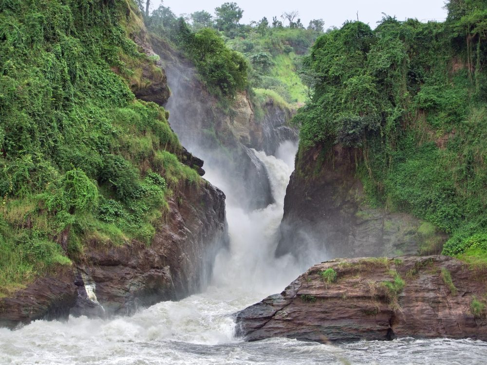
The road descends and ends at a parking lot, a 5-minute walk above the falls with the big rapids right in front of you. A park ranger asked for my receipt. I didn’t have one and never saw a gate or toll booth, but did pass through an area with a lot of construction (I was informed this is the new park entrance) 45 km from the falls. He informed me of the fees: $45 for the park entrance, 20,000 for the car and $10 to walk the 5 minutes to the falls. A boat to see the falls from below (not running today because of all the rain) was $30 and a game drive was $20.
All this was news to me. I offered to pay the $10 to walk down to the falls and he accepted. Despite the rain, the falls are an incredible maelstrom of water as it squeezes through the canyon. I got back in the car and drove back to Masindi. At the “park entrance, a ranger stopped me and asked for the receipt. Without one, I said I wasn’t paying and drove off. I expected to encounter the police but didn’t.
In Masindi, I got gas and found a place for the night.
Murchinson Falls NP. The park covers an area of 1,503 square miles (3,893 sq km) creating the largest national park in Uganda. The national park is part of the larger Murchison Falls Conservation Area which includes Bugungu Wildlife Reserve and Karuma Wildlife Reserve creating over 2,072 square miles (5,366 sq km) of protected wilderness.
Although the park is renowned for the stunningly powerful Murchison Falls, it is an amazing place to take a safari and witness some of Africa’s incredible wildlife. The falls are on the Victoria or White Nile River. The park is home to the largest population of Nile crocodiles.
In addition to the large population of crocodiles, there are around 75 species of mammals. Some of the larger and more popular wildlife species include lion, leopard, giraffe, elephant, waterbuck, hartebeest, buffalo, hippopotamus, and chimpanzee. There are about 800 chimpanzees living across the national park boundaries.
Murchison Falls National Park is also a haven for bird watchers with over 450 species of birds that nest or migrate through the park. The Goliath Heron is a nice treat to see since it is the largest heron in the world. Many of the species are waterfowl, however, there are many other species such as the red-throated bee-eater.
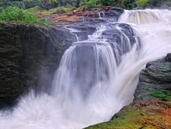
Murchison Falls. Murchison Falls National Park is best known, though, for the most powerful waterfall in the world. Every second, the equivalent of 200 bathtubs full of water is forced through a gorge less than seven paces wide. The pressure is so great that the ground trembles around it. The water then plummets 43 meters before flowing out toward Lake Albert as a placid river whose banks are dense with hippos, crocodiles, waterbuck and buffaloes.
Sir Samuel Baker and Lady Florence Baker were the first Europeans to see Murchison Falls. Nearly a hundred years later, Ernest and Mary Hemingway survived after their plane plunged to the earth near Murchison Falls, only to have the rescue plane crash and burn, too, on take-off. Days later, the Hemingways read their own misinformed obituaries in the papers from the safety of their hotel in Nairobi.
Rabongo Forest Trail. This guided nature hike is a walking safari with chances to see chimpanzees, monkeys, and other wildlife. The grasslands do attract predator species, so it is important to pay attention to your guide.
Masindi (pop 94,622) is on the road between Kampala (211km southeast) and the Murchison Falls National Park and 57 km northeast of Hoima, the largest city in the Bunyoro sub-region. 1,227 m above sea level.
It was visited by Samuel and Florence Baker, British explorers and anti-slavery campaigners, from 25 April 1872 to 14 June 1873. The Baker expedition was forced to withdraw because of the hostility of the King of Bunyoro. The White Fathers founded a mission in the 1910s. The town was developed as a commercial centre due to trade in cotton during the second half of the 19th century.
The Masindi Hotel, the oldest hotel in the country, built in 1923 is where Ernest Hemingway, Katharine Hepburn and Humphrey Bogart stayed ON Pross Residence, Masindi. A little out of the way, 8.1 km from Masindi centre and out in the countryside, I found this on Booking.com, didn’t reserve and simply showed up at their gate. Double bed, ensuite, with all I need (they brought a kettle). 40,000 ($11).
For the third night in a row, I had an avocado, 2 tomatoes and added some red onion. With salt and pepper, this is so tasty.
ON Prosse Motel. 8.4 km from Masindi, this was cheap at $10 and quite nice with a hot shower, kettle and a good bed. Mark is pleasant and accommodating. Breakfast was offered but I declined.
Day 6 Sat April 1
Still trying to navigate the Tanzania visa site, I didn’t leave till 08:45, drove to Hoima and turned down to Kibiro.
Kibiro (Salt producing village) (10/09/1997) is an 800-900-year-old industry consisting of fishing on Lake Albert and the production of ash salt which is obtained by recycling residual earth with fresh soil which is spread on salt gardens for the salty water to get absorbed by the capillary system. Through repeated scraping, spreading and heaping of the salty soil over seven days, it is leached and the scam is built to the crystallization point to produce the ash salt. The residual soil from leaching is then mixed with fresh soil to repeat the salt production process.
Salt production was and is a female hereditary occupation. Before metallic vessels, pottery ware was used during the leaching and boiling processes with potsherds as deep as 4 metres.
Kibiro village is a sandy beach along Lake Albert where food does not grow. Depend on the exchange of salt and fish for food with farming communities on the plateau above the Ugandan side of the Western Rift Valley.
It is 23 km to Kibora, the last 9 km on dirt and rocky road. Drive 7 km on a very narrow dirt road that could be a disaster after all the recent rain but is very well designed – rounded in the middle so that it drains well. There was only one short muddy section. Pass many walkers carrying loads on their heads and gathering firewood. The road starts to descend significantly to the lake far below and fortunately turns rocky. One short section was washed out and requires AWD with some clearance to get back up. 900 m from the village park and walk down as there is a very steep, rocky, low-range 4WD section.
The village is quite large with many houses. A few muddy salt pans are on the north side but it didn’t appear that any active salt production was happening. Shipping out the salt on this road would be an issue. Free
Lake Albert is located on the border between Uganda and the Democratic Republic of the Congo. It is Africa’s seventh-largest lake, as well as the second-biggest of Uganda’s Great Lakes. It is the northernmost of the chain of lakes in the Albertine Rift, the western branch of the East African Rift.
It is about 160 kilometres (99 mi) long and 30 kilometres (19 mi) wide, with a maximum depth of 51 metres (167 ft), and a surface elevation of 619 metres (2,031 ft) above sea level.
Lake Albert is part of the complicated system of the Upper Nile. Its main sources are the White Nile, ultimately coming from Lake Victoria to the southeast, and the Semliki River, which is from Lake Edward to the southwest. The water of the Victoria Nile is much less saline than that of Lake Albert. The lake’s outlet, at its northernmost tip, is the Albert Nile section of the White Nile. The river later becomes known as the Mountain Nile when its course enters South Sudan.
At the southern end of the lake, where the Semliki comes in are swamps. The Rwenzori Mountains are to the south of the lake and the northwest, the Blue Mountains. The few settlements along the shore include Butiaba and Pakwach.
Lake Albert’s water temperature is relatively stable throughout, typically around 27–29 °C (81–84 °F), and even its deeper sections contain oxygen.
Lake Albert is home to many aquatic and semi-aquatic animals, including the river hippopotamus, Ugandan kob, and red as well as Nile lechwe, Nile crocodile, Nile monitor lizard, African softshell turtle, Central African mud turtle, and Williams’ mud turtle. Also present is the giant African bullfrog and the rock python, which can be observed warming themselves on smooth rocks near the water’s edge. Several terrestrial (but water-loving) snakes, lizards, and amphibians reside at the lake. Water birds are numerous, and include pink-backed pelican, goliath heron, white-faced whistling duck, African fish eagle, wattled plover, and greater flamingo. Several stork species are commonly seen patrolling the shallow areas; the saddle-billed, yellow-billed, open-billed, Hamerkop (hammerhead), European white, and the rare shoebill storks all frequent the lakeshore and shallows, and roost in surrounding tall trees.
Fish. There are 55 fish species in Lake Albert. After Nile crocodiles and larger carnivorous birds, the largest predator in the lake is the Nile perch (native; unlike in other Rift Valley lakes where it’s introduced & invasive), as well as the fearsome-looking elongate tigerfish, African tigerfish, and the electric catfish.
In 1864, the explorers Samuel Baker and Flóra von Sass found the lake and renamed it after the recently deceased Prince Albert, consort of Queen Victoria. European colonialists operated shipping on the lake. The British planned shipping on Lake Albert as part of a network of railway, river steamer and lake steamer services linking British interests in Egypt, east Africa and southern Africa. The John I. Thornycroft & Company shipyard at Woolston, Hampshire built the cargo and passenger ship SS Robert Coryndon for this purpose in 1930. Winston Churchill described the ship as “the best library afloat” and Ernest Hemingway called her “magnificence on water”. She either was scuttled in 1962 or sank in 1964. She remains unsalvaged and partly submerged in the lake at Butyaba landing site.
Heritage Oil and Tullow Oil have announced major oil finds in the Lake Albert basin, with estimates that the multi-billion barrel field will prove to be the largest onshore field found in sub-Saharan Africa for more than twenty years.
In March 2014, a boat carrying Congolese refugees capsized in Lake Albert, killing more than 250 people.
On 26 December 2016, a boat carrying 45 members and fans of a local village football team capsized in Lake Albert killing at least 30 people.
On 24 December 2020, thirty people died when a boat capsized en route from Uganda to Congo. The passengers were concerned about travel restrictions related to the COVID-19 pandemic in Africa.
The Kibiro settlement on Lake Albert has cultural and archeological significance.
FORT PORTAL A clean and well-organised highland town surrounded by extensive tea plantations, several fine colonial buildings and a superb Rwenzori backdrop. Bicycle in Fort Portal to the top of the world or Kyaninga Lodge.
Lugard Monument. This consists of a male lion in the middle of a roundabout in Fort Portal. Lugard was the Military Administrator of Uganda from 26 December 1890 to May 1892. While administering Uganda, he journeyed around the Rwenzori Mountains to Lake Edward, mapping a large area of the country.
Tooro Botanical Gardens. A lovely garden with indigenous trees, medicinal plants, flower beds and hedges. There is a nice trail system. The highlight may be all the birds. 10,000US
Amabeere Caves. This limestone cave has had most of the formations broken. The highlight is the waterfall. 47,000US. This is not worth the price. The caves are 10 km from Fort Portal, with the last 600 m on a heavily eroded road.
KARESE. The gateway to the Rwenzori National Park.
The entrance road to the NP is not marked with any sign and I drove past it into Karese. I looked for nearby accommodation and there were three near the entrance to the park. I drove back 10 km and turned west onto Muramba Road. The road is quite rocky and thus handles rain well. It was a slow 17 km to the accommodation. Pass through almost continuous impoverished villages where bananas and coffee seem to be the economy. Several homes had large plastic sheets covered with coffee beans.
ON Rwenzori Turaco View Campsite. 18,000US. I had booked it but there was no record. All the dorm rooms were occupied so I had one of the three tents, all well protected from the rain (and it poured for a couple of hours in the early evening). The tent had two twin beds that were quite comfortable. The campsite has a restaurant and serves meals regularly. The lovely young woman working there (and who seemed to be doing all the work from showing guests around, cooking and serving meals) was not paid anything and whose only income was from tips. She wanted to be a guide. This place seems to be where all the tours stay.
There was a couple from Israel and another from Croatia. The Israelis were doing the 5-day Rwenzori Circuit ($850 each). Their guide appeared in the morning with the gear – rubber boots, a heavy and bulky sleeping bag, expedition pants, balaclava and heavy gloves. It looked like a pretty Mickey Mouse operation for that sort of money.
Day 7 Sun Apr 2
I was up early for a breakfast of cold Rolex (chapati with omelette), I was off at 8 to drive the one km to the park. Pass Summit Guest Camp and the Rwenzori Community Camp (tents only). The road narrows more and I arrived at the large gate with an office and two large sign boards. I walked for about 10 minutes down the good trail and returned.
RWENZORI MOUNTAINS NATIONAL PARK WHS. is a mountain range in south-west Uganda bordering the Democratic Republic of Congo. It is 120 km long and 48 km wide with its highest peak at Mt. Stanley (5109 m/16,761 ft). Ice cap has retreated from 6.4 to 1.28 sq km. Local Bakonzo mountain people.
100,000 ha in western Uganda with Africa’s third highest peak (Mount Margherita: 5,109 m). The region’s glaciers, waterfalls and lakes make it one of Africa’s most beautiful alpine areas. The park has many endangered species and rich and unusual flora including the giant heather.
Just kilometres from the equator, where it is contiguous with the Virunga National Park in the Democratic Republic of Congo (DRC). After Kilimanjaro and Mount Kenya, the Park includes a much larger alpine area than either, 70% over 2,500 m. The Rwenzori Mountains are the highest and most permanent sources of the River Nile. Species endemic to the Albertine Rift in the higher altitude are giant heathers, groundsels and lobelias called “Africa’s botanical big game”
The Rwenzoris are the legendary “Mountains of the Moon” – snow-capped peaks, glaciers, V-shaped valleys, fast-flowing rivers with magnificent waterfalls, clear blue lakes and unique flora that contribute to the area’s exceptional natural beauty.
Because of their altitudinal range, and the nearly constant temperatures, humidity and high insolation. African forest elephant, eastern chimpanzee and l’Hoest’s monkey. The endangered Rwenzori black-fronted or red duiker.
Rwenzori Mountains Trek. The Central Trail network follows a clockwise direction around Sella Mt, Mt Edward and Mt Kinyazewa. Follow the River Mubeku to the centre of the circuit below the big peaks at the west end of the park,
I then continued my drive south passing the following.
Lake George has a total surface area of 250 square kilometres and is a part of the African Great Lakes system, although it is not considered one of the Great Lakes. Like the other lakes in the region, it was renamed after a member of the British royal family, Prince George, later to become King George V. Lake George drains to the southwest into Lake Edward through the Kazinga Channel.
The explorer Henry Morton Stanley was the first European to see the lake in 1875, after following the course of the Katonga River from Lake Victoria during his trans-African expedition. On his second visit to the area, in 1888 during the Emin Pasha Relief Expedition, Stanley discovered Lake Edward, and realizing that there were two independent lakes, he gave Lake George its current name.
Uganda equator.
Queen Elizabeth National Park Between Lake Edward and Lake George. Ugandan Kob is an endemic antelope, crested crane. Drive among volcanic crater lakes on the south edge of the Ruwenzori Range. The Kazinga Channel at Mweya has hippos, once 30,000. I saw one beside the road just after crossing the bridge. The Channel narrows at the bridge but is very wide and slow-moving on both sides. The park is home to the famous tree-climbing lions.
Queen Elizabeth is a completely flat grassland spotted with trees. Despite no towns, the excellent road has a full complement of speed bumps to prevent traffic accidents.
At the south end of the park, arrive at an intersection. It was 22 km to the main gate of the park and 39 km to Lake Katwe on dirt/gavel so I decided to not go.
OTHER DESTINATIONS
I didn’t see the following: Lake Edward access in only via the DRC.
Lake Katwe is known throughout Uganda for its substantial salt production and has been producing high-quality salt for many years. Geographically, Lake Katwe is found within an explosion crater in the formerly active volcanic area northeast of Lake Edward and southeast of Lake George. The lake is found in the small run-down town of Katwe on the outskirts of the Queen Elizabeth National Park in the Kasese district and covers an area of approximately eight square miles. Its shores are lined with small ponds or pans of water from which salt is extracted from the bottom in a process called salt panning.
The salt content of the lake waters is approximately 13.5 %. The lake bed is 0.8 meters thick and contains approximately over 12 million tonnes of salt, varying in composition and depth and has salt stocks estimated to sustain an industrial extraction plant with a production rate of 7 tonnes of salt per hour for 34 years. On this basis, an industry to mechanize the salt production process was put in place in the 1970s by Idi Amin Dada but the project never took off to date and the Katwe salt project is now on the brink of privatization.
Lake Edward is one of the smaller African Great Lakes. It is located in the Albertine Rift, the western branch of the East African Rift, on the border between the Democratic Republic of the Congo (DRC) and Uganda, with its northern shore a few kilometres south of the equator.
Henry Morton Stanley first saw the lake in 1888, during the Emin Pasha Relief Expedition. The lake was named in honour of Albert Edward, Prince of Wales, son of then-British monarch Queen Victoria, and later to become King Edward VII.
In 2014, the lake was the center of an oil dispute. SOCO International entered the premises of the Virunga National Park where the lake is situated to prospect for oil. However, villagers and workers who attempted to stop the oil company from entering the area were beaten up and even kidnapped and tortured.
Lake Edward lies at an elevation of 920 metres, is 77 kilometres long by 40 kilometres wide at its maximum points, and covers a total surface area of 2,325 square kilometres, making it the 15th-largest on the continent. The lake is fed by the Nyamugasani River, the Ishasha River, the Rutshuru River, the Ntungwe River, and the Rwindi River. Lake George to the northeast empties into it via the Kazinga Channel. Lake Edward empties to the north via the Semliki River into Lake Albert.
The western escarpment of the Great Rift Valley towers up to 2,000 metres (6,600 ft) above the western shore of the lake. The southern and eastern shores are flat lava plains. The Ruwenzori Mountains are 20 kilometres (12 mi) north of the lake.
Volcanism. The region shows much evidence of volcanic activity over the last 5000 years. The Katwe-Kikorongo and Bunyaruguru Volcanic Fields, with extensive cones and craters, lie on either side of the Kazinga Channel on the northwest shore of the lake. It is thought that Lakes George and Edward used to be joined as one larger lake, but lava from these fields flowed in and divided it, leaving only the Kazinga Channel as the remnant of the past union. To the south lies the May-ya-Moto thermally active volcano 30 kilometres (19 mi) away, and the Nyamuragira volcano in the western Virunga Mountains lies 80 kilometres (50 mi) south, but its lava flows have reached the lake in the past.
Katwe-Kikorongo field features dozens of large craters and cones covering an area of 30 kilometres by 15 kilometres between lakes Edward and George and includes seven crater lakes. The largest of these, the 2.5 km long Lake Katwe, occupies a crater 4 km across and is separated from Lake Edward by just 300 metres of land. The crater is about 100 m deep, and Lake Katwe’s surface is about 40 m lower than Lake Edward’s.
The similarly sized Bunyaruguru field on the other side of the Kazinga Channel contains about 30 crater lakes, some of which are larger than Katwe.
Lake Edward lies completely within the Virunga National Park (Congo) and the Queen Elizabeth National Park (Uganda) and does not have extensive human habitation on its shores, except at Ishango (DRC) in the north. About two-thirds of its waters are in the DRC and one-third in Uganda.
The nearest cities are Kasese in Uganda to the northeast and Butembo in the DRC to the northwest, which are respectively about 50 km and 150 km distant by road.
In the 1970s, Lake Edward held a population of around 29,000 hippos, but poaching caused a 95% decline with only a few hundred by the end of 2006. 2019 – 1,500 individuals. The hippopotamus is poached for meat and the ivory is found in its teeth.
Hippos produce dung, which feeds tilapia, a once-abundant fish species found in Lake Edward. One hippo could produce around 25 kg of dung per day, which could feed thousands of tilapia within the ecosystem. With the hippopotamus population declining, the tilapia fish started to disappear as well.
After leaving Queen Elizabeth NP, climb up into the high hills. There are great views for hundreds of kilometres. Pass several villages, crater lakes and many tea plantations. One field was being harvested with hand-held “mowers”.
In the town of Ishaka, I had a decision to make. Bwindi Impenetrable NP was 219 km and a 4 1/2 hours drive to the southwest and then a return on the same road. As I had no desire to pay $700 to see the gorillas and it meant another day of car hire, I decided to forego a WHS.
I turned east towards Mbara on a lousy road full of potholes but few speed bumps.
After Mbara, I had another decision to make – continue to Entebbe for the night or see the two Tentative WHS in Uganda – Central (Kampala etc)
OTHER DESTINATIONS
BWINI IMPENETRABLE NATIONAL PARK WHS in southwestern Uganda along the DRC border next to the Virunga National Park and on the edge of the Albertine Rift. 321 square km of montane and lowland forest, it is accessible only on foot.
Gorilla tracking is the park’s main tourist attraction, and it generates much revenue for the Uganda Wildlife Authority. Uganda, Rwanda, and the Democratic Republic of the Congo are the only countries where it is possible to visit mountain gorillas:
120 mammals, 10 are primates. Along with mountain gorillas, species in the park include the common chimpanzee, black and white colobus monkeys, L’Hoest’s monkey, African elephant, African green broadbill, cream-banded swallowtail, red-tailed monkeys, vervets, hornbills and turacos.
348 birds, 220 butterflies, 27 frogs, chameleons, geckos, and many endangered species. Floristically, more than 1,000 flowering plant species, including 163 trees and 104 ferns.
Mountain gorillas. 459 individual mountain gorillas (2019), almost half of all the mountain gorillas in the world. The rest are in the nearby Virunga Mountains – 300 in 1997, and 400 in 2018.
14 habituated mountain gorilla groups are open to tourism. The Batwa pygmy people were evicted from the forest. Gorilla tracking became a tourist activity in April 1993. An armed guard now accompanies every tour group.
Bwindi gorilla’s diet is markedly higher in fruit than that of the Virunga population, and the Bwindi gorillas, even silverbacks, are more likely to climb trees to feed on foliage, fruits, and epiphytes. In some months, the Bwindi gorilla diet is very similar to that of Bwindi chimpanzees. It was also found that Bwindi gorillas travel farther per day than Virunga gorillas and are more likely to build their nests in trees.
An endangered species, a total population of 650 individuals. No mountain gorillas are in captivity.
Bordering the park more than 300 people per square kilometre, some of the poorest people in Uganda. 90% live on subsistence agriculture.
The national parks are beautiful and, uncrowded. Uganda Wildlife Authority (UWA) website or for details of gorilla tracking, safaris, chimpanzee tracking and more. Prices in several parks seem to be set at 20 (1 day), and 35 (2 days).
Go on gorilla tracking. Permit booked a long time ahead gets 1 hour on very close hand of a group of highly endangered mountain gorillas in their natural habitat. Permits were US$600 each. Rwanda is now charging $1,500 for gorilla trekking in its parks.
Geography and climate. Kabale town is 29 km by road to the park. The park is at the edge of the Western Rift Valley in the highest parts of the Kigezi Highlands: very rugged, with narrow valleys intersected by rivers and steep hills. Elevations 1,190 to 2,607 metres, 60 % over 2,000 m.
Tropical climate. 7 to 15 °C to a maximum of 20 to 27 °C. Its annual rainfall 55 to 75 in. Rain season: March to April and from September to November.
Old, complex, and biologically rich with diverse species partly due to the large variations of elevation and the forest was a refuge for species during glaciations.
220 tree species, and more than 50% of Uganda’s tree species, and more than 100 ferns. The brown mahogany is a threatened plant species in the park.
Domestic flights from Entebbe International Airport, which land at Kihihi Airstrip and Kisoro Airstrip. Tourist accommodations include a lodge, tented camps, and rooms run by the community located near the Buhoma entrance gate.
Kisoro — located in the extreme southwest corner of Uganda next to the borders with Rwanda and DR Congo. It is the closest town to Mgahinga Gorilla National Park and Bwindi Impenetrable National Park.
Mgahinga Gorilla National Park Tentative WHS (MGNP) (30/01/2007) is in the Virunga Mountains with active volcanic peaks. Golden Monkeys. Area of 33.9 km2.. 7,306 to 13,540 ft high. Part of the Nile River watershed area. It is contiguous with Rwanda’s Volcanoes National Park and the southern sector of Virunga National Park in the Democratic Republic of the Congo.
The park is about 15 km south of Kisoro and 55 km west of Kabale.
Two rainy seasons: Feb to May; and Sept to Dec.
Primates include mountain gorillas (Gorilla beringei beringei) and golden monkeys (Cercopithecus kandti). The iconic mountain gorillas (around 30 individuals split between one habituated and two unhabituated groups) and the charismatic golden monkey (an Albertine Rift Endemic whose range is now restricted to the Virungas and one other forest in Rwanda). The checklist of 76 mammal species includes black-and-white colobus, leopard, elephant, giant forest hog, bushpig, buffalo, bushbuck, black-fronted duiker, and several varieties of rodents, bats and small predators.
Popular tourist activities include mountain gorilla tracking, golden monkey tracking, volcano hiking, nature walks including to the gorge platform, bird watching and meeting the Batwa community. Tourists visiting Mgahinga Gorilla National Park make a 9-hour drive from Kampala to reach the park. The park is also connected by daily domestic flights from Entebbe International Airport and on to Kihihi Airstrip, which land at Kisoro Airport.
Kibale Forest National Park near Fort Portal. Chimpanzee, 13 species primates. Birding at Kasese Crater Lakes. Breathtaking landscapes. Mahoma waterfalls.
Lake Bunyonyi near Kabale is a Crater Lake, 2000 m above sea level. 29 small islands, all accessible by local canoe or boat.
Return to Uganda – Central (Kampala, Entebbe, Masaka)
On the way to Entebbe, I decided to make a detour to see these two Tentative WHS. The road to Ntusi was initially one km of good pavement, two km of good dirt and 68 km of awful rutted narrow dirt road. Each hill had an eroded water course down the middle so driving was on tire-wide ridges. There is always a hope that you will hit a good road but this was crap to Ntusi, a depressing village.
Ntusi (man-made mounds and Basin) Tentative WHS (10/09/1997) is a Late Iron Age archaeological site located in SW Uganda dating from the 10th-15th centuries. Has two large mounds and manmade scraped valley basins called, bwogero. Bigo bya Mugenyi lies 13 km to the north of Ntusi.
The mounds are forty meters in diameter with a depth 4 meters. Used as a refuse dump ornamental goods were recovered in the male mound. The upper layers of the mound revealed carved ivory, ostrich eggshell beads, glass beads, and copper trade goods.
the boogers are the result of Ntusi residents digging down to the water table to bring water to the surface for their cattle to drink.
Bigo bya Mugyenyi Tentative WHS (Archaeological Earthworks) (10/09/1997). Extensive ditches and berms are part of ancient earthworks in SW Uganda. Two elements: the first consists of a long, irregular ditch and bank that forms the outer boundary. Connects the Katonga River in the east and the Kakinga swamp to the west.
The second element consists of four irregularly shaped ditches and bank enclosures connected to the Katonga River by a single ditch. Three mounds are associated with the central enclosures; two within and one immediately to the west. When combined, the Bigo earthworks extend for more than 10 kilometres.
Dated to roughly AD 1300-1500. Interpreted as defensive fortifications. Has been suggested that Bigo’s outer earthworks were constructed to keep elephants from damaging crops, while the central earthworks were constructed to protect the site’s rulers from attack.
The road east from Ntusi was still packed dirt but an improvement. I passed a truck full of army dudes, who, just as I passed all jumped off the truck and appeared to have wanted me to stop. So I drove like a madman. After 34 km of the dirt, I hit a good highway and cruised along at 120-140 hoping that they would not catch me. They didn’t.
Equator Monument, Kayabwe. On both sides of the highway, there are two concrete circles with UGANDA EQUATOR at the top. Both were mobbed by groups of school kids taking photos.
Social Innovation Museum (SINA), Mpigi. The beginning of the 5.6 km road here had big water channels and I decided to try another road. This was a big mistake and ended up on a very narrow village road and two steep sections the car had difficulty with even with AWD.
This was started in 2008 when children from an orphanage were helped through secondary school but then could not afford to go to university due to lack of funds. The goal was to help them become entrepreneurs. The organization soon grew to 8 locations in East Africa. This particular site was built in 2014.
It is a series of buildings. most round constructed of plastic soda bottles and roofed with innovative materials like thatch, reeds, and rubber tires. There is a meeting hall, kitchen, workspaces, living quarters, and accommodation for guests ($25-100/night). There is no museum as such. Free
The traffic back towards Kampala was horrendous at 5 in the afternoon. I finally accessed the Entebbe Expressway (toll 5000US), a beautiful 4-lane divided highway with a 100km/hr speed.
ENTEBBE is a collection of some upmarket residential streets and a slew of government offices on the shores of Lake Victoria, dominated by State House, the official residence of the Ugandan President. The location of Uganda’s only international airport, about 1 hour south of Kampala by road.
The Kambala/Entebbe expressway is a big 4-lane divided highway with a speed limit of 100 km/hr. There are constant small cavalcades of government officials accompanied by the army in front and rear with their lights and sirens on racing through the city. The president is cavalcades of 20 vehicles including 3 doctors.
Airports: Entebbe (EBB)
ON Elementis Entebbe Guesthouse. 65,000US. A nice house with privates and two dorm rooms. I was the only guest. It is right on the water and the party with music continued till late.
I went to the mall, bought groceries and ate at a KFC, the only restaurant there (and the only US fast food chain in Uganda.
Day 8 Mon April 3
I was up early, had my own breakfast and saw the following sites in Entebbe. I extended my car rental to include today.
Aero Beach statues, planes and other weird stuff. In the NM Bizzarium series, this shallow beach is fronted by an “airplane graveyard” – two large passenger jets, a huge helicopter, several fighter jets, and a few smaller planes. Also are several painted cement figures, and a few animals. Free
Entebbe Zoo (Uganda Wildlife Conservation Education). A nice zoo with good enclosures for the “big ten” animals of Uganda, a beach, and accommodations. $15 (expensive for a zoo and not worth if it you have seen them in the wild. Most zoos are for children.
Entebbe Botanic Gardens. Seen as a drive-through, they have rainforests, medicinal plants, baobab trees, and flowers. 20,000US.
Reptile Village. A rustic “community project”, there are pythons; cobras (including a gorgeous spitting cobra), mambas, 2 crocodiles, turtles and chameleons (hang rotting fish to attract flies). 15,000US
The drive here is terrible and it was the same road back.
I drove into Kampala, saw the temple (my last site in Uganda – Central) and returned to Acacia Villa. Kampala traffic was awful. I should have listened to Google Maps and gone off the expressway but ended up with a disastrous 5.6 km drive through the city back to the temple.
Kampala
Shri Sanatan Dharma Mandal Temple is a replica of Somnath Temple in Gujarat constructed in the late 50s and inaugurated in 1961. It was built without any iron bars or steel to its dome over four floors high. It is the first Shikha Baddha Temple outside India.

Europcar Rental arrived at Acacia Villa at noon to get the car. I had a needed rest day with little to do.
ON Acacia Villa (where I had previously stayed for two nights).
Day 10 Tue April 4
Flight (Kenya Airways Ticket #706161490235201) from Entebbe to ADD April 5 @3:45-05:10 NBO; 07:20-09:20 ADD so I went to the Entebbe Airpot sharing a taxi with Timur, a chess player from Uzbekistan for 50,000 – the Airport is 35 km away. The check-in did not open till 01:00 and one had to stay in the Waiting Room for all that time. I laid out my mat and needed my sleeping bag. I slept a little. I was all too eager to leave Uganda which I found kind of depressing.
OTHER DESTINATIONS
World of Nature: Ngamba Island Chimpanzee Sanctuary
Lakes: Lake Kyoga
Saint Paul’s Cathedral Namirembe
GENERAL
Uganda is bordered to the east by Kenya, to the north by South Sudan, to the west by the Democratic Republic of the Congo, to the southwest by Rwanda, and to the south by Tanzania. Famously called the Pearl of Africa by Winston Churchill, it is home to one of the most diverse and concentrated ranges of African fauna including the highly endangered mountain gorilla and the endangered common chimpanzee.
Understand
During Uganda’s era of British colonialism, settlement by Europeans was not allowed, and today there are few Caucasians in Uganda. The term for whites is muzungu shouted out by children, not derogatory.
Accessible and affordable, but not high tourism, more edge, more authenticity and less predictability. Real Africa, the urban bustle of Kampala then lush subsistence farming and small villages. Roads are rough, people are friendly, and not everything moves according to schedule or to plan.
Most travellers come for the gorilla safari, but other major draws are the chimpanzees, ornithology, trekking the Rwenzoris and visiting the source of The Nile River.
History. Hunter-gatherers until 1,700 to 2,300 years ago. Empire of Kitara (14-15th centuries).
Arab traders moved inland in the 1830s, British in the 1860s searching for the source of the Nile. Protestant missionaries in 1877, Catholic missionaries in 1879. British East Africa Company in 1888, ruled as a protectorate from 1894. 1900 – 1920, a sleeping sickness epidemic killed more than 250,000 people.
Independence from Britain in 1962. 1966, Prime Minister Milton Obote suspended the constitution and assumed all government powers. In 1971, Obote’s government was ousted in a military coup led by Idi Amin Dada. Absolute power. Idi Amin’s eight-year rule produced economic decline, social disintegration, and massive human rights violations. The Acholi and Langi ethnic groups were persecuted as they had supported Obote and made up a large part of the army. 100,000 – 300,000 Ugandans were murdered during Amin’s reign of terror.
In October 1978, Tanzanian armed forces repulsed an incursion of Amin’s troops into Tanzanian territory. The Tanzanian army, backed by Ugandan exiles waged a war of liberation against Amin’s troops and the Libyan soldiers sent to help him. On April 11, 1979, Kampala was captured, and Amin fled with his remaining forces. This led to the return of Obote, who was deposed once more in 1985 by General Tito Okello. Okello ruled for six months until he was deposed after the so-called “bush war” by the National Resistance Army (NRA) operating under the leadership of the current president, Yoweri Museveni, and various rebel groups, including the Federal Democratic Movement of Andrew Kayiira, and another belonging to John Nkwanga.
Museveni has been in power since 1986. In the mid to late 1990s, he was lauded by the West as part of a new generation of African leaders. His presidency has been marred, however, by invading and occupying the Democratic Republic of the Congo during the Second Congo War, resulting in an estimated 5.4 million deaths since 1998, and by participating in other conflicts in the Great Lakes region of Africa. He has struggled for years in the civil war against the Lord’s Resistance Army, which has been guilty of numerous crimes against humanity, including child slavery, the Atiak massacre, and other mass murders. Conflict in northern Uganda has killed thousands and displaced millions.
Parliament abolished presidential term limits in 2005, allegedly because Museveni used public funds to pay US$2,000 to each member of parliament who supported the measure.
Climate. Although Equatorial, the climate is not uniform as the altitude modifies the climate. Southern Uganda is wetter. At Entebbe, rain season is from Mar/June and Nov/Dec.
Rwenzori in the southwest on the border with DR Congo receives heavy rain all year round. The south of the country is heavily influenced by one of the world’s biggest lakes, Lake Victoria, which contains many islands and increases cloudiness and rainfall.
Cities and towns.
Kabale — a small town in the far south of the country near Lake Bunyonyi.
Other destinations
North is a relatively flat and dry savanna. West is mountainous and lush and the centre of Uganda hosts large forests.
Ajai Game Reserve in the north, a small reserve at 16,600 hectares, located on the east bank of the Albert Nile
Kidepo Valley National Park extreme NE corner on the South Sudan border. Apoka Lodge. Elephant, zebra, nile buffalo, kob, cheetah, ostrich and the Secretary Bird.
Mabira Forest – between Kampala and Jinja, hiking, birds and monkeys. Enter directly from the main road. The different trails are marked on the trees with red, yellow and blue. Even with the longest round, it won´t take you more than 2 hours if you are only hiking.
Ssese Islands on Victoria Lake, beaches, some forest. Beware of bilharzia in Lake Victoria. 3-8 hours via ferry from Entebbe or Masaka. Busy island is 45 minutes from Entebbe. Campsite, dorm.
GET IN
Visa. e-visas, apply online for a visa before travelling to Uganda. The single-entry tourist visa now costs USD 50 and is valid for 30 days. Must be printed out for immigration.
East Africa Tourist Visa costs USD 100 and allows up to 90 days of travel in Uganda, Rwanda and Kenya. Apply before travel or on arrival.
By plane. Entebbe Airport hub for Uganda.
Uganda Airlines Entebbe to Mombasa, Nairobi, Juba, Kilimanjaro, Zanzibar, Dar es Salaam, Mogadishu, Bujumbura, and Kinshasa. To London, Dubai, Guangzhou, Mumbai, Zanzibar, Johannesburg, Harare, Lusaka, Lubumbashi, Accra, Khartoum, Kigali and Cairo South African Airways daily Johannesburg.
Turkish Airlines Istanbul hub
Emirates and Flydubai offer direct flights to Dubai
Ethiopian Airlines from Addis Ababa, Juba and Kigali.
Fastjet fly from Dar es Salaam and Kilimanjaro.
Kenya Airways to Nairobi four times a day.
KLM daily from Amsterdam
Brussels Airlines from Brussels
Egypt Air flies three times a week to Cairo.
Qatar Airways flies daily to Doha.
RwandAir flies from Kigali, Juba and Nairobi.
By train. No passenger service.
By car. With your own vehicle can enter from Kenya through Busia and Malaba. A Carnet du Passage is required. 90-day tourist visa (US$100). Proof of insurance and yellow fever vaccination
By bus. Several reputable international bus companies from Nairobi, Kigali, Bujumbura, Goma, Juba, and Dar es Salaam to Kampala.
By boat. Ferries to Sesses Islands in Lake Victoria.
GET AROUND
Car, bus or truck and guide 80- 200
Independent. Combination of BodaBoda (small mopeds, motorcycles, accidents common, agree on the price), local taxi (“matatu” in Kenya), bus and evil. private car (National Parks).
By bus. decent two classes of buses. The “taxis” (“matatus”) are minibuses or commuter vans, which run fixed routes.
Bus connections are more common in Western & Northern Uganda, while Eastern Uganda is more commonly served by taxis. Most companies in Uganda use Chinese-made buses 5 seats per row.
By plane. Domestic flights might be a good and fast alternative to dusty bus rides.
By taxi. Minibus taxis are relatively cheap, frequent (in Kampala), and have many stops along the way, fixed routes.
Private taxis – Fares negotiable over long distances as no meters.
By car. Most main roads are metalled. Minor roads are hard-packed earth (murum) and deteriorate in heavy rains and washboard frequently. Untarred roads, if wet, may be impassable in the mountainous southwest. Buses, trucks, pedestrians, livestock, cyclists, dogs and the odd police roadblock. Drive cautiously and stay alert.
4×4 with a driver (most places have accommodation and meals for drivers) costs USD100.00 per day (not including fuel). Use one of the major agencies. Orutindo car rental prices are moderate see Queen Elizabeth National Park, Kisore etc., where the bus connections are poor.
Talk. English lingua franca, Ugandans speak with a thick accent. Dozens of African languages, most commonly Luganda, Swahili in the North and East.
Accommodation
If you go on the higher end you will pay high prices, over $100 per night. Standard traveller hotels will have simple rooms with shared bathrooms for around 8,000 to 15,000 shillings. Many places will rent you a tent, or place to pitch a tent for the budget traveller. The Backpackers chain has hostel-like accommodations at a variety of locations in Uganda including Kampala, Mbarara, Kisoro and Jinja. A night stay will run you 7 to 9 dollars US a day. These are most frequently used by Truck tours which are popular with the less independent traveller.
Very good accommodation possibilities you will find in each bigger town. There are also Bed & Breakfast establishments to give you have a homely feel away from home at the lowest rates. In the more touristic region of southwestern Uganda and at Lake Bunyonyi there are also resorts and campsites. Some offer a quiet and traditional stay in the beauty of nature and the lake, others are more tourist with bars, crowds and entertainment. Most hotels in larger cities will be plentiful. But if you go to more rural cities in the north then you can run into problems. The price of a hotel will run the gambit of cost. And the most expensive is not always the best. Ask to see the room before exchanging any money. If they refuse then you saved yourself from a bad situation. If possible ask someone where a guest house is located or a clean hotel. We have found that is the best way to find a clean, quiet place.
National Parks. The accommodations provided in the national parks by UWA are generally of a good standard and are quite inexpensive compared to alternatives. As little as USD5.00 or less per person per night.
Few moderately priced options are available, and the high-end, while expensive, are substandard compared to the high-end options of Kenya, Tanzania, and South Africa..
Uganda-travel.jimdo.com has home stays and village stays.
Stay safe. Travel north to Murchison Falls National Park and Ajai Game Reserve is perfectly safe. Note that overlanders from Tanzania and Kenya regularly make the trip routing through Jinja.
As in any urban area, parts of Kampala can be unsafe. Homosexuality is illegal, and attitudes are extremely hostile. Ugandans have absolutely no problems straight-up murdering a suspected LGBT person right on a busy street
Stay healthy. AIDS/HIV infection rate is very high. Ebola and Marburg hemorrhagic fevers have been endemic. Malaria – use Coartem.
Diarrhea disease – use ciprofloxacin
Schistosomiasis (Bilharzia) – in many lakes
Respect. Uganda has a fairly conservative Christian/Muslim-based society. Not acceptable to wear skimpy clothing. Never criticize religion. Most Ugandan adults would never wear shorts except if playing sport.
Contact. Orange also offers mobile broadband.
HISTORY
Precolonial Uganda. Much of Uganda was inhabited by Central Sudanic and Kuliak speaking of farmers and herders before Bantu speakers arrived in the south and Nilotic speakers in the northeast 3,000 years ago in 1,000 BC. By 1500 AD, they were assimilated into Bantu-speaking cultures south of Mount Elgon, the Nile River, and Lake Kyoga.
Arab traders moved into the land from the Indian Ocean coast of East Africa in the 1830s for trade and commerce. Later, the British arrived in Uganda with a predisposition against the kingdom of Bunyoro and sided with the kingdom of Buganda.
In the 1860s, while Arabs sought influence from the north, British explorers searching for the source of the Nile arrived in Uganda. They were followed by British Anglican missionaries who arrived in the kingdom of Buganda in 1877 and French Catholic missionaries in 1879.
From 1886, there was a series of religious wars in Buganda, initially between Muslims and Christians and then, from 1890, between ba-Ingleza Protestants and ba-Fransa Catholics. Because of civil unrest and financial burdens, IBEAC claimed that it was unable to “maintain its occupation” in the region. British commercial interests were ardent to protect the trade route of the Nile, which prompted the British government to annex Buganda and adjoining territories to create the Uganda Protectorate in 1894.
Uganda Protectorate (1894–1962). The Protectorate of Uganda was a protectorate of the British Empire from 1894 to 1962. In 1894 the territory was extended to Toro in 1900, Ankole in 1901, and Bunyoro in 1933) to an area that roughly corresponds to that of present-day Uganda.
In the 1890s, 32,000 labourers from British India were recruited to East Africa under indentured labour contracts to construct the Uganda Railway. Most of the surviving Indians returned home, but 6,724 decided to remain in East Africa after the line’s completion. Subsequently, some became traders and took control of cotton ginning and sartorial retail.
From 1900 to 1920, a sleeping sickness epidemic in the southern part of Uganda, along the north shores of Lake Victoria, killed more than 250,000 people.
World War II recruited 77,143 soldiers to serve in the King’s African Rifles and fought in the Western Desert campaign, the Abyssinian campaign, the Battle of Madagascar and the Burma campaign.
Independence (1962 to 1965). Uganda gained independence from the UK on 9 October 1962 with Queen Elizabeth II as head of state and Queen of Uganda. In October 1963, Uganda became a republic but maintained its membership in the Commonwealth of Nations.
The first post-independence government had Milton Obote as prime minister, with the Buganda Kabaka (King) Edward Muteesa II holding the largely ceremonial position of president.
Buganda crisis (1962–1966). From the moment the British created the Uganda protectorate, the issue of how to manage the largest monarchy within the framework of a unitary state had always been a problem. Milton Obote, of the Uganda People’s Congress (UPC) wanted to rectify what they saw as the regional inequality that favoured Buganda’s special status.
In Obote’s absence from Parliament, the illegal plundering of ivory and gold from the Congo had been orchestrated by Obote’s army chief of staff, Colonel Idi Amin. Obote eventually gave Amin more power as the Army Commander position. The lines were now drawn for a showdown between Buganda and the Central government.
In May 1966, the Kabaka made his move. He asked for foreign help, and the Buganda parliament demanded that the Uganda government leave Buganda (including the capital, Kampala). In response, Obote ordered Idi Amin to attack the Kabaka’s palace. The battle for the Kabaka’s palace was fierce – the Kabaka’s guards putting up more resistance than had been expected. The British-trained Captain – the Kabaka with about 120 armed men kept Idi Amin at bay for twelve hours. It is estimated that up to 2,000 people died in the battle which ended when the army called in heavier guns and overran the palace. The anticipated countryside uprising in Buganda did not materialize and a few hours later a beaming Obote met the press to relish his victory. The Kabaka escaped over the palace walls and was transported into exile in London by supporters. He died there three years later.
1966–1971 (before the coup). In 1966, following a power struggle between the Obote-led government and King Muteesa, Obote suspended the constitution and removed the ceremonial president and vice-president. In 1967, a new constitution proclaimed Uganda a republic and abolished the traditional kingdoms. Obote was declared the president.
1971 –1979 (end of Amin regime). After a military coup on 25 January 1971, Obote was deposed from power and General Idi Amin seized control of the country. Amin ruled Uganda as dictator with the support of the military for the next eight years. He carried out mass killings within the country to maintain his rule. An estimated 80,000–500,000 Ugandans died during his regime. Aside from his brutalities, he forcibly removed the entrepreneurial Indian minority from Uganda.
In June 1976, Palestinian terrorists hijacked an Air France flight and forced it to land at Entebbe airport. One hundred of the 250 passengers originally on board were held hostage until an Israeli commando raid rescued them ten days later. Amin’s reign was ended after the Uganda-Tanzania War in 1979, in which Tanzanian forces aided by Ugandan exiles invaded Uganda.
1979–present. Belligerents of the Second Congo War. On 19 December 2005, the International Court of Justice found against Uganda, in a case brought by the Democratic Republic of the Congo, for illegal invasion of its territory, and violation of human rights.
Yoweri Museveni has been president since his forces toppled the previous regime in January 1986. Political parties in Uganda were restricted in their activities beginning that year, in a measure ostensibly designed to reduce sectarian violence. In the non-party “Movement” system instituted by Museveni, political parties continued to exist, but they could operate only a headquarters office. They could not open branches, hold rallies, or field candidates directly (although electoral candidates could belong to political parties). A constitutional referendum cancelled this nineteen-year ban on multi-party politics in July 2005.
In 1993, Pope John Paul II visited Uganda during his 6-day pastoral trip to urge Ugandans to seek reconciliation. During mass celebrations, he paid homage to the slain Christian martyrs.
In the mid-to-late 1990s, Museveni was lauded by Western countries as part of a new generation of African leaders.
On 20 February 2011, the Uganda Electoral Commission declared the incumbent president Yoweri Kaguta Museveni the winning candidate. The opposition condemned them as full of sham and rigging.
Since August 2012, the hacktivist group Anonymous has threatened Ugandan officials and hacked official government websites over its anti-gay bills. Some international donors have threatened to cut financial aid to the country if anti-gay bills continue.
President Yoweri Museveni has ruled the country since 1986 and he was latest re-elected in January 2021 presidential elections. According to official results, Museveni won the elections with 58% of the vote while popstar-turned-politician Bobi Wine had 35%. The opposition challenged the result because of allegations of widespread fraud and irregularities.
Geography. Uganda is located between 1º S and 4º N latitude, and between 30º E and 35º E longitude. Its geography is very diverse consisting of volcanic hills, mountains, and lakes. The country sits at an average of 900 meters above sea level. Both the eastern and western borders of Uganda have mountains. The Ruwenzori mountain range contains the highest peak in Uganda, Alexandra (5,094 m)..
Lakes and rivers. Much of the south of the country is heavily influenced by one of the world’s biggest lakes, Lake Victoria, which contains many islands. The most important cities are located in the south, near this lake, including the capital Kampala and the nearby city of Entebbe. Lake Kyoga is in the centre of the country and is surrounded by extensive marshy areas.
Also Lake Albert, Lake Edward, and the smaller Lake George. It lies almost completely within the Nile basin. The Victoria Nile drains from Lake Victoria into Lake Kyoga and thence into Lake Albert on the Congolese border. It then runs northwards into South Sudan. An area in eastern Uganda is drained by the Suam River, part of the internal drainage basin of Lake Turkana. The extreme north-eastern part of Uganda drains into the Lotikipi Basin, which is primarily in Kenya.
Protected Areas. Uganda has 60 protected areas, including ten national parks: Bwindi Impenetrable National Park and Rwenzori Mountains National Park (both UNESCO World Heritage Sites), Kibale National Park, Kidepo Valley National Park, Lake Mburo National Park, Mgahinga Gorilla National Park, Mount Elgon National Park, Murchison Falls National Park, Queen Elizabeth National Park, and Semuliki National Park.
Uganda is home to a vast number of species, including a population of mountain gorillas in the Bwindi Impenetrable National Park, gorillas and golden monkeys in the Mgahinga Gorilla National Park, and hippos in the Murchison Falls National Park. Jackfruit can also be found throughout the country.
The country had a 2019 Forest Landscape Integrity Index mean score of 4.36/10, ranking it 128th globally out of 172 countries.
