
Kenya April 10-20, 2023
With a population of more than 47.6 million in the 2019 census, Kenya is the 27th most populous country in the world and the 7th most populous in Africa. Kenya’s capital and largest city is Nairobi, while its oldest, currently second largest city, and first capital is the coastal city of Mombasa. Kisumu City is the third-largest city and is also an inland port on Lake Victoria. As of 2020, Kenya is the third-largest economy in sub-Saharan Africa after Nigeria and South Africa. Kenya is bordered by South Sudan to the northwest, Ethiopia to the north, Somalia to the east, Uganda to the west, Tanzania to the south, and the Indian Ocean to the southeast. Its geography, climate and population vary widely, ranging from cold snow-capped mountaintops (Batian, Nelion and Point Lenana on Mount Kenya) with vast surrounding forests, wildlife and fertile agricultural regions to temperate climates in western and rift valley counties and dry less fertile arid and semi-arid areas and absolute deserts (Chalbi Desert and Nyiri Desert).
Kenya’s earliest inhabitants were hunter-gatherers, like the present-day Hadza people. Cushitic speakers first settled in Kenya’s lowlands between 3,200 and 1,300 BC. Nilotic-speaking pastoralists began migrating from present-day South Sudan into Kenya around 500 BC. Bantu people settled at the coast and the interior between 250 BC and 500 AD. European contact began in 1500 AD with the Portuguese, and effective colonization began in the 19th century during the European exploration of the interior. Modern-day Kenya emerged from a protectorate established by the British in 1895 and the subsequent Kenya Colony, which began in 1920. Numerous disputes between the UK and the colony led to the Mau Mau Revolution, which began in 1952, and the Declaration of Independence in 1963. After independence, Kenya remained a member of the Commonwealth.
Kenya is the most powerful economy in East Africa. A middle-income country with a fast-growing middle class, however, it is still a developing country. Agriculture is the largest sector: tea and coffee are traditional cash crops, while fresh flowers are a fast-growing export. The service industry is also a major economic driver, particularly tourism. Most Kenyans seem optimistic about the country’s future. Strong sense of national pride.
A few areas off the beaten track where a white or yellow face will attract cries of “Mzungu! Mzungu!” (Kiswahili: “white person”) from local children.
Capital. Nairobi
Languages. Official – Swahili, English. National – Swahili
Ethnic groups. 17.13% Kikuyu, 14.35% Luhya, 13.37% Kalenjin, 10.65% Luo, 9.81% Kamba, 5.85% Somali, 5.68% Kisii, 5.23% Mijikenda, 4.15% Meru, 13.78% Others
Religion. 85.5% Christianity — 60.8% Protestantism, 20.6% Catholicism, 4.1% Other Christian; 10.9% Islam, 1.6% No religion, 0.7% Traditional faiths, 1.3% Others
Area. Total 580,367 km2 (224,081 sq mi) (48th), Water 2.3%
Population. (2022) 55,864,655 (27th). Density 78/km2 (202.0/sq mi) (124th)
GDP (PPP). Total $333.1 billion (61st). Per capita $333.1 billion (61th)
GDP (Nominal). Total $114.8 billion (64th). Per capita $2,255 (146th)
Gini. 40.6 medium
HDI. 0.575 medium · 152nd
Drives. Left
Calling code. +254
Electrical plug. 3-prong English.
Visas. eVisa in advance before arriving in Kenya http://evisa.go.ke/evisa.html US$51.
A single-entry visa allows re-entry from Rwanda, Tanzania, and Uganda.
East African Tourist Visa. This is a multiple-entry visa for Kenya, Rwanda and Uganda and is valid for 3 months. The cost is $101 and that visa cannot be extended. This visa is to use only within these 3 countries. If you leave the area (for example, to Tanzania) and then come back, the visa is expired and you will have to buy a new one.
Money. Kenyan Shilling (KES) 1US$ – 137.72 KES; 1€ = 144.54 KES; 1CA$ = 98.74 KES xe.com April 2023.
There are many ATMs and credit cards are accepted everywhere.
Mpeza. Most Kenyans use Mpeza, a phone money app. It took at least 30 minutes to set it up. With a Safaricom SIM, the Mpeza is part of that SIM but the woman added a new SIM that eventually disabled my original SIM requiring pins and PUK codes. When trying to fix it, I got a new SIM and lost my data that was on the first.
It requires withdrawing money from an ATM to charge it. Then go to the app, 2 clicks to add the business code, state the amount, add your Mpeza pin and click OK a bunch of times. A credit card (used almost everywhere) is much faster.
SIM cards. Kenya is one of the best countries with good internet coverage in Sub-Saharan Africa. Safaricom 10 GB for 2000 + 100KS unlimited time.
Safaricom or Airtel: Safaricom 4G is in all major cities and plan to roll out in all 47 counties.
Climate. Tropical climate moderated by altitude. It’s hot and humid at the coast, temperate inland, and very dry in the north and northeast parts.
Sunshine all year round and summer clothes are worn throughout the year. However, it is usually cool at night and early in the morning. Nairobi and many highland towns are cold in June and August.
The long rainy season occurs from April to June. The short rainy season occurs from October to December. The rainfall is sometimes heavy and often falls in the afternoons and evenings. The hottest period is from February to March and the coldest is from July to August.
The annual animal migration – especially migration of the wildebeest – occurs between June and September with millions of animals taking part and has been a popular event for filmmakers to capture.
Dealing with Police. As Kenya is a developing nation, government remuneration for public services is sometimes poor for low-ranking officers like constables. They frequently seek out bribes to earn a more livable income. Rarely will police harass foreigners in the street or charge them falsely. The most common reasons foreigners end up at the police station are genuine, most often traffic-related offences such as seatbelts or wrong turns. In recent years however, officers have also been known to arrest those who are not carrying their original passport – normally a copy of the ID page and your Kenyan visa page along with a government-issued ID should suffice. If you do have your passport, it is common for an officer to take up to 5 minutes meticulously going through each page to find fault or incite paranoia.
If you are pulled aside by an officer for something seemingly petty, there is a high chance they are simply seeking a bribe and do not intend to arrest you. Do not appear anxious but instead remain calm, assertive and speak as few words as possible. Kenyans typically pay police bribes of 200-500 KS for traffic violations while foreigners have been asked for 5,000 KS (about $50 USD) or more. If this does happen and you wish to pay you can attempt to barter to a lower amount (1,000 – 2,000 KS). It is not advisable to offer a bribe immediately, instead treat it as a very last resort. On a positive side, due to easy access to internet and smartphones, most traffic police have been videotaped taking bribe leading to their dismissal. Most of them will either be very conscious while taking bribes.
If you need to deal with the police because you are a victim of a crime, understand that the system is in fact somewhat functional, though the process will be slow and tedious. There is generally no justice delivered for minor crimes such as theft, and obtaining a report for insurance purposes can be an arduous process. Some stations may need you to provide them with pen and paper or pay for transport costs for the officers. It is also not unheard of for police officers to seek bribes for helping you or giving you priority in their often overwhelming workload.
Never let a police get into the car – usually they want to drive you to the police station but this usually results in higher bribes.
My solution was to say that I have no cash and no Mpeza and only have a credit card. One accepted a 500 KS bribe (instead of being arrested), another 1000KS instead of $100 fine for smoking while walking down a street, and another for pulling over and stopping on a main road through Eldoret (I wouldn’t let him in the car and argued so much, he let me go).
Smoke-free places. The Tobacco Control Regulations prohibit smoking on streets, sidewalks, and verandas adjacent to public places.
OBSERVATIONS
1. People. The ordinary Kenyan is extremely nice. I had many occurrences of great people – the guy at the airport who helped me find a place to sleep, the veterinarian who was going to visit Guelph and asked me about racism in Canada; and the guys on the bridge who gave directions.
Virtually every woman has hair attachments and long false nails (both of which I find very unattractive).
But after a long week in this country, I have come to the conclusion that Kenyans are hobbled with wrote learning education system, and you produce poorly functioning people. Who would put up with this level of corruption, especially from the police without a revolt?
2. Driving in Kenya. Most roads are only two lane with narrow shoulders, and trucks go extremely slow (often only 25 km/hr, the ones passing 30 km/hr). Motorcycles and tuk-tuks never ride on the shoulder and obstruct the left half of the lane. If passing, oncoming seem to not slow down and also rarely pulls over onto the shoulder. Vehicles being passed also don’t pull over to the shoulder to give you more room. The motorcycles usually wear winter jackets and have touques and scarves like it is the middle of winter. The many share taxis also drive slowly and park on part of the driving lane. Most drivers are slow and timid passers.
There are vanishingly few speed signs, often the only ones are the end of the 50 km/hr speed after towns and virtually never what the upper speed limit is.
Every town has two to four speed bumps, all car killers unlike the ones in Uganda that can be taken at speed. Some major highways have speed bumps with no building in sight. There is a solid central line almost everywhere and the police like to stop anyone passing – when it is often very safe.
There is some radar on overhead gantries, but frequent police who stand on both sides of the highways, sometimes with radar. They make trumped up charges (see above) and demand heavy fines or threaten arrest.
It is astonishing how much traffic goes through Nyeri – everything from Nairobi (and the Rift Valley in between) and from the west and north of the country, must go through this city. Then a number of trucks, many carrying containers, make for very slow driving. The city itself is a bottleneck as there is no bypass.
3. Towns. They are frequent and extremely unattractive. On either side of the highway is a 20-30 m strip of dirt, grass or mud often with a drainage ditch between it and the small shops in every town. In this strip are often small “shops” consisting of poles supporting a galvanized roof and usually used for selling produce.
4. Food. Street food is very uncommon, the only shops on the highways sell vegetables and fruit. The menus in most restaurants have little food that appeals to me. The only Western fast food are a few KFCs. One good chain is Javas with a good menu.
5. Religion. This is a very religious country. The churches are full on Sundays and the coastal area is strongly Muslim. The mini-vans are adorned with all kinds of Christian phrases: “With Jesus, there is hope”, “Without Jesus, you’re SINgle”.
After 4 days in Kenya, I slowly grew to dislike this country – the police and their trumped up charges, demands large fines; the traffic with many slow trucks, motorcycles taking up a lot of the lanes, unattractive towns, high national park fees (all over US$60 + a fee for your vehicle). I think they have been spoiled by 2-week tourists willing to spend anything for a wildlife experience.
Sun April 9
Flight Ethiopian JUB-ADD @11:00-14:00 ET358 Ticket #071 2137626565
To board, I showed my vaccination record, Kenya visa, and arrival flight and then, for the first time ever, had to show an onward flight out of Kenya. He refused to budge as it was a firm requirement. David supplied his hot spot and I booked a fake ticket through onwardflights.com. Unfortunately, it had an Ethiopian Air connection and would not show up on his computer. I then booked a direct flight for April 20 on Expedia.com (Tanzania Airlines) for $150 that could be cancelled within 24 hours. He did not have to electronically confirm that, asked for my yellow fever card (that I have not shown for 4 months) and finally issued my two boarding passes JUB-ADD and ADD to NBO@22:55.
I was the last person to board 35 minutes before take-off.
In ADD I said goodbye to Ammon. We had a great 4 days together. He is a smart guy with lots of travel experience. With 162 countries (#3 in Canada), most of his travel was during one continuous 7-year period in his twenties. We had lots of travel stories to share.
Day 1 Mon Apr 10 (Easter Monday)
Flight Ethiopian Airlines ADD-NBO 22:50-01.00 ET308 Ticket #071 1614915812
Immigration in Nairobi: Fast and easy with a printed Kenya visa. He did not ask for an onward flight!
Rather than get a taxi in the middle of the night, I decided to try to sleep at the Nairobi Airport and go into town in the morning. I mistakenly exited arrivals (the best place to sleep and entered departures where there was nowhere to sleep. A lovely man took me down the street and up into the second floor next to the parking garage. I laid out my mat and sleeping bag and had a good, quiet sleep in a corner.
In the morning, I had a good mocha and withdrew 20,000 KS from an ATM and while calling an Uber, a private guy said that he would drive me to the YWCA (18 km) for 1200 KS. He was a pleasant guy, didn’t have correct change and accepted 1000KS.
I arrived at the YWCA at 08:30 and was given a room well before check-in.
I slept for 2 hours and started my usual walk about to see the NM sites in downtown Nairobi.
NAIROBI (pop 4,397,073 2019; metro 10.8 million 2022) is the capital and largest city of Kenya. The name is derived from the Maasai phrase Enkare Nairobi, which translates to “place of cool waters“, a reference to the Nairobi River which flows through the city. The city is commonly referred to as The Green City in the Sun.
Nairobi was founded in 1899 by colonial authorities in British East Africa, as a rail depot on the Uganda – Kenya Railway. The town quickly grew to replace Mombasa as the capital of Kenya in 1907. During Kenya’s colonial period, the city became a centre for the colony’s coffee, tea and sisal industry. The city lies in the south-central part of Kenya, at an elevation of 1,795 metres (5,889 ft).
Nairobi is home of the Kenyan Parliament Buildings and hosts thousands of Kenyan businesses and over 1000 major international companies and organizations, including the United Nations Environment Programme (UN Environment). Nairobi is an established hub for business and culture. The Nairobi Securities Exchange (NSE) is one of the largest in Africa and the second-oldest exchange on the continent. It also contains the Nairobi National Park.
Airports; Jomo Kenyatta (NBO); Nairobi – Wilson (WIL)
I left the hostel (fronted by a huge open space surrounded by high blue corrugated metal sheeting) and lit a cigarette as I walked the few blocks to the cathedral. Police said it was illegal to smoke anywhere in Nairobi and demanded a $100 payment. I argued and he countered “no one is above the law, it is not an excuse that you don’t know the law”, on and on. It became apparent that I was not going to give up and asked for how much money I had. The fine went down to 2000KS (about $14) and I finally paid 1000KS, “for lunch for me and the other 4 cops sitting in the edge of the trees”. I errored in not getting his name and badge number. I subsequently asked around if it was illegal to smoke anywhere in Nairobi and got conflicting answers. The guards at the cathedral said that the way to deal with bribes is to get his name and badge number and report him.
All Saints Cathedral. In a large complex including a 5-story school, this lovely stone Anglican church dates to . It has a large rose window and stained glass windows of the 12 evangelists. One memorial plaque is to Lord Baden Powell. The church was closed but a Scottish family arrived with a guide and obtained access to the interior.
Uhuru Park. In the NM Urban Legends series, this is a large urban park with grass, trees, some small lakes, a stream (with many arched bridges) and an old passenger jetliner.
Nyayo Memorial. Sitting in the park behind the blue corrugated fencing is this complex black marble plinth with a raised hand holding a torch. In Nairobi’s Central Park, the four-sided monument was erected in 1988 by the Kanu regime to honour retired president Daniel Arap Moi. The Italian marbled monument was erected to mark the 10th anniversary of the Nyaro era and 25 years of independence) for Sh18 million. The monument was gradually defaced as a way of making ‘political statements’. Today, the water that gushed all around is no more, the marbles are falling off and plants have sprouted on the edges of the tumbled sections.
Holy Family Basilica. This 1963 RC church has a large cross and coloured glass behind a decorated stone mesh in large windows behind the altar and cross.
Nairobi Gallery. A lovely small museum with exhibition rooms surrounding a central space. A large jewelry section with a broad cross-section of African jewelry (silver, gold, beadwork, lost wax technique, beads, aluminum cook wear melted down), one room dedicated to Pio, an Indian human rights activist assassinated in 1965 (3 days before Malcolm X, not a coincidence), a room of office furniture, the
Maasai Market. I think Google Maps showed the wrong Maasai Market. This one was a small collection of white tents in two rows all with high-end clothing.
Co-operative Bank House. A 20-story skyscraper with a light tan marble facade and black glass.
Memorial Peace Museum. In a small park it this memorial to the Aug 7, 1998 bombing of the American Embassy. The museum gives the history with many photographs and remnants of the embassy. A black memorial wall contains all the names, only 7 with Western-sounding surnames. It is fronted with a Yin-Yang fountain. The park has several “peace” statements. 50KS to enter the park and 350KS for the museum.
More than 200 people were killed in nearly simultaneous truck bomb explosions, this one and one at the United States Embassy in Dar es Salaam, Tanzania, The bombings are widely believed to have been revenge for U.S. involvement in the extradition, and alleged torture, of four members of Egyptian Islamic Jihad (EIJ) who had been arrested in Albania in the two months prior to the attacks for a series of murders in Egypt. It was masterminded by Osama bin Laden.
Two very large, 2,000-pound (900 kg) destructive devices made of 400 to 500 cylinders of TNT (about the size of drink cans), ammonium nitrate, aluminum powder, and detonating cord. The bombings were scheduled for August 7, the eighth anniversary of the arrival of U.S. troops in Saudi Arabia during the early stages of the Persian Gulf War, likely a choice by Osama bin Laden.
213 people were killed and 4,000 in Nairobi wounded. Although the attacks were directed at U.S. facilities, the vast majority of casualties were local citizens of the two African countries. Twelve Americans were killed.
Jomo Kenyatta Monument. The great man’s sitting statue is on a cement plinth. Both the monument and conference centre were the scene of a Nairobi music festival for choirs.
Kenyatta (1897 – 22 August 1978) was a Kenyan anti-colonial activist and politician who governed Kenya as its Prime Minister from 1963 to 1964 and then as its first President from 1964 to his death in 1978. He was the country’s first indigenous president and played a significant role in the transformation of Kenya from a colony of the British Empire into an independent republic.
In 1952, he was among the Kapenguria Six arrested and charged with masterminding the anti-colonial Mau Mau Uprising. Although protesting his innocence—a view shared by later historians—he was convicted. He remained imprisoned at Lokitaung until 1959 and was then exiled to Lodwar until 1961. His rule was criticised as dictatorial, authoritarian, and neocolonial, of favouring Kikuyu over other ethnic groups, and of facilitating the growth of widespread corruption.
Kenyatta International Conference Centre. Sitting on a large rectangular base is the main hall, a round space topped with a large conical “bee-hive”.
Tom Mboya Memorial Statue. On a black/white marble plinth, this is a statue of a standing man holding up his right arm. Tom Mboya (1930 – 5 July 1969) was a Kenyan trade unionist, educator, Pan-Africanist, author, independence activist, and statesman. Mboya’s intelligence, charm, leadership, and oratory skills won him admiration from all over the world.
He was assassinated at the age of 38 when he was gunned down on 5 July 1969. Nahashon Isaac Njenga Njoroge was convicted for the murder and later hanged. After his arrest, Njoroge asked: “Why don’t you go after the big man?” Suspicions arose that Mboya’s shooting was a political assassination. Outrage over his assassination led to riots in the major cities of Kenya. A statue of Mboya was installed on Moi Avenue, where he was killed.
Jamia Mosque. Dated 1925-1933, this has a nice courtyard with a fountain and a large low-ceiling prayer hall with many sleeping bodies. The area in front of the mihrab was a reading area with many studiously pouring over their Korans. There was no minbar but a large chair sitting in the mihrab.
Khoja Mosque. An unlikely-looking mosque dating to 1922 – stone, Victorian architecture, 3-story, has a large clocktower, red window frames and doors and no indication it is a mosque. It sits on an angled corner. A fellow I asked about it, said that he had never seen the doors open but believed it was usually open during prayer times.
ON YWCA Parkview Suites. A lovely private room, large double bed, 2 couches and a small kitchen with no stove or fridge. I asked for and was given a kettle. The place is eerily quiet with no other visible guests. However the shower was cold.
Day2 Tue Apr 11
After a quiet morning, I had a walk about starting with getting a SIM card (on the Easter Monday holiday, my first day, none were open). Safaricom 10gb for 2000 + 100KS unlimited time.
Fairmont The Norfolk Hotel. In the NM Urban Legends series, this hotel was built in 1903 and joined Fairmont Hotels in 1907. The outside is Tudor but the inside is lovely modern (bar, restaurant) and beautiful outdoor garden.
Nairobi National Museum. Has all the items often found in national museums but with a preponderance of natural history (a mammoth number of stuffed birds). Good discussion of human evolution. 1200KS but free today
Kenya Railway Museum. Besides the usual old steam locomotives and passenger cars, there is a wide selection of railway artifacts from old stations. Mini train for kids. 800KS
It was a long 2.6km walk here from the national museum under the large elevated freeway with a sidewalk is great disrepair (a lot of mud).
Britam Tower is the tallest building in Kenya, 195 metres (640 ft) high with 32 floors. It has a unique prismic shape, that starts as an equal four sided square footprint and ends with a two sided roof with a 60 metres (197 ft) mast, containing three helical wind turbines.
The building is the international headquarters of Britam. Other tenants are financial institutions, diplomatic missions, private companies and multinational corporations.
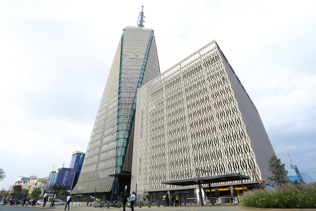
UAP Old Mutual Tower is a 33-storey office complex and was the tallest structure in Kenya upon its completion in 2015, surpassing Times Tower which had held that record for 15 years and now passed by the Bitam Tower. It is woned by the UAP Old Mutual Group, a financial services conglomerate headquartered in Kenya.

Day 3 Wed Apr 12
Porto Car Hire (+254 723607140; [email protected]) arrived at 08:30 with a Toyota car (CA$70/day), we went to a mall to withdraw money to pay for it and then Mpesa to get a SIM for that (which really screwed things up – with Safaricom there is only one SIM that includes mpeza). He was a very pleasant guy to deal with, brought the car to the YMCA and picked it up afterward. The drawbacks were the unavailability of complete insurance coverage ($500 deductible) and that payment had to be in cash necessitating two trips to an ATM as I extended the rental to a fourth day. It ended up being a great car with good power. The AWD came in very handy when I went to Thimlich Ohinga.
I started my drive heading east.
Nairobi NP – virtually in Nairobi and a great option to see large games for those on a tight schedule
After the park, I continued east and then north through the southern part of Kenya-East.
==============================================================
KENYA – EAST (Embu, Meru, Kitui, Machakos)
Borders: Ethiopia-Kenya
Athi River. African city
Machakos. African city. I stopped at a grocery store and had a great hot dog – a big bun, fried onions and a true beef dog.
Kituluni Gravity / Magnetic / Magic Hill. In the NM Bizzarium series, water apparently flows uphill and vehicles in neutral go uphill. On a switchback on the road, I think this is all a myth as the engineer who did the road construction did a tilt opposite the slope.
Kangundo. African city.
After Kangundo, I had a driving adventure. the road was quite potholed, turned into nice new pavement but then bypassed Ol Donyo Sabuk mountain to the east, it was an awful eroded dirt road to the highway – large areas of mud, heavy erosion.
==============================================================
Return to Kenya-Nairobi and Central
Thika is an industrial town and a major commerce hub on the A2 road 42 kilometres (26 mi), Northeast of Nairobi, near the confluence of the Thika and Chania Rivers.
This the headquarters of Del Monte Pineapples with fields everywhere.
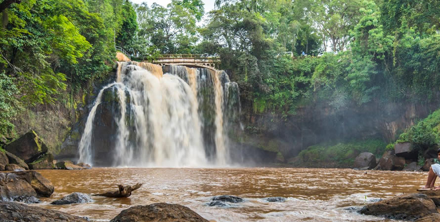
Chania Falls. Go over a steep, tree-lined cliff just in front of the Blue Post Hotel’s restaurant. The best views are from the restaurant’s veranda.
Karatina Market, Karatina. Supposedly the second largest open air market in Africa (after Kano Nigeria), it has 4 metal roofed areas only for selling grains and beans. South are many vegetable sellers under umbrellas and some small shops lining the south wall. There is also a large 3-story building – I only walked through the bottom, half was only tomatoes, the other half carrots.
NYERI (pop 150,000) is situated in the densely populated and fertile Central Highlands about 150 km north of Nairobi, lying between the eastern base of the Aberdare Range, which forms part of the eastern end of the Great Rift Valley, and the western slopes of Mount Kenya.
The town has a relatively low cost of living in comparison to Nairobi and other major urban centres in Kenya. In Kenya’s fertile highlands, food and water are plentiful and relatively cheap.
It is astonishing how much traffic goes through Nyeri – everything from Nairobi (and the Rift Valley in between) and from the west and north of the country, must go through this city. Then number of trucks, many carrying containers, make for very slow driving. The city itself is a bottleneck as there is no bypass.
Nyeri National Museum. A quaint museum centred on the former lower courtroom. Surrounded by a photo gallery of Kenya’s history plus a few artifacts along one wall. Given a guided tour. Free
Baden-Powell Museum. Lord Baden-Powell, the founder of the Boy Scout Association, spent his last three years at Paxtu cottage in the Outspan Hotel, where this museum is located. The ultimate scoutmaster’s retirement was somewhat poetic: to ‘outspan’ is to unhook your oxen at the end of a long journey. Paxtu is now filled with scouting scarfs and paraphernalia.
Baden-Powell clearly loved his final home: he once wrote ‘the nearer to Nyeri, the nearer to bliss’. Famed tiger hunter Jim Corbett later occupied the grounds. 500KS
Baden-Powell (1857 – 8 January 1941) was a British Army officer, writer, founder and first Chief Scout of the world-wide Scout Movement, and founder, with his sister Agnes, of the world-wide Girl Guide / Girl Scout Movement. Baden-Powell authored the first editions of the seminal work Scouting for Boys, which was an inspiration for the Scout Movement.
Baden-Powell served in the British Army from 1876 until 1910 in India and Africa. In 1899, during the Second Boer War in South Africa, Baden-Powell successfully defended the town in the Siege of Mafeking. Several of his books, written for military reconnaissance and scout training in his African years, were also read by boys. In August 1907, he held a demonstration camp, the Brownsea Island Scout camp, which is now seen as the beginning of Scouting. In 1910 Baden-Powell retired from the army and formed The Scout Association.
He gave guidance to the Scout and Girl Guide movements until retiring in 1937. Baden-Powell lived his last years in Nyeri, Kenya, where he died and was buried in 1941. His grave is a national monument. 500KS
ON Trumpet Inn, Nyeri. A basic hotel is 2200KS for a standard room. I couldn’t find anything to eat and had my fall-back meal – tomatoes and avocados.
Day 4 Thur April 13
From Nyeri, I drove 38 km north to Naro Moru and turned east on a gravel road to just enter the park. The mountain was totally enshrouded in cloud.
Mount Kenya National Park/Natural Forest WHS. At 5,199 m, Mount Kenya is the second highest peak in Africa. It is an ancient extinct volcano, which during its period of activity (3.1-2.6 million years ago) is thought to have risen to 6,500 m. There are 12 remnant glaciers on the mountain, all receding rapidly, and four secondary peaks that sit at the head of the U-shaped glacial valleys. With its rugged glacier-clad summits and forested middle slopes, Mount Kenya is one of the most impressive landscapes in East Africa. Lower lying scenic foothills and arid habitats of high biodiversity next to semi-arid savanna grasslands. The area also lies within the traditional migrating route of the African elephant population.
Mount Kenya straddles the equator about 193 km north-east of Nairobi and about 480 km from the Kenyan coast.
The property includes the Lewa Wildlife Conservancy and Ngare Ndare Forest Reserve (LWC-NNFR) to the north. The two component parts of the property are connected via a wildlife corridor. Also incorporates the forested foothills and steep valleys of the lower slopes of Mount Kenya and extends northwards onto the relatively flat, arid, volcanic soils supporting grassland and open woodland communities on the Laikipia plain.
Mount Kenya is also regarded as a holy mountain by all the communities (Kikuyu and Meru) living adjacent to it. They use the mountain for traditional rituals based on the belief that their traditional God Ngai and his wife Mumbi live on the peak of the mountain.
The park is reached on the Nanyuki-Isiolo road via Sirimon Track or Nyeri-Nanyuki road near Naro Moru. The park is also reachable via Chogoria on the Embu – Meru road, about 150km north of Nairobi. This is an asphalt road that circles the base of the mountain, linking the area towns of Naro Moru, Nanyuki, Meru and Embu.
Aberdare Mountains Tentative WHS: (12/02/2010). (or Nyandarua) mountains are an isolated volcanic range that forms the easternmost wall of the Great Rift Valley, to the east of the high Kinangop/Laikipia plateau. They are around 100 km long from north to south (the northern end almost reaching the equator). There are two main peaks, Ol Donyo Lesatima (3,999 m) to the north and Kinangop (3, 906 m) to the south, separated by a long ‘saddle’ of land above 3,000 m. The small peak of Kipipiri (3, 349m) flanks the main range to the west, linked to it by a formerly forested valley at around 2,700 m.
Cool and cloudy Rift Valley park with lots of large game, and over 250 species of bird recorded
Deep ravines cut through the forested eastern and western slopes and there are many clear streams and waterfalls. The park is renowned for its torrential waterfalls plunging from cloud-shrouded heights to spray-filled ravines. They include the magnificent Karuru falls, which drop 300m, the impressive Gura falls which torrent from the opposite side of the same Gorge, the drop of the Chania falls and the enchanting Gura falls which cascade across the yawning mouth of the Queen’s Cave. Mist and rain occur throughout much of the year, with precipitation varying from around 1,000 mm on the drier north-western slopes to as much as 3,000 mm in the south-east. The vegetation varies with altitude. A rich alpine and sub-alpine flora, including species of Senecio spp, Lobelia spp, Erica spp, Helichrysum spp and tussock grasses, gives way at around 3,000 m to bamboo Arundinaria alpine and then montane rainforest.
The National Park lies mainly above the tree line, with some forest and scrub at lower altitude in the salient near Nyeri. The Aberdares Forest Reserve (103,300 ha) occupies the lower slopes, in three main blocks that almost surround the Park, with Kipipiri Forest Reserve (5,100 ha) tacked on to the west. The southern boundary of the Aberdares Forest Reserve adjoins the Kikuyu Escarpment Forest.
The Aberdares are an extremely important water catchment for the Tana River system, for the northern Ewaso Nyiro River and for Lake Naivasha, and provide much of the water supply for Nairobi and adjoining districts.
Wildlife in the area 52 of Kenya’s 67 Afro tropical Highlands’ species. Bongo estimated at over 65 individuals in forest, Leopard, Black Rhinoceros, African Elephant (some 1,500 are resident:) and Giant Forest Hog and a population of Lions, the African Golden Cat, a rare species and Spotted Hyena.
Aberdares mountains present one of the most impressive landscapes of Eastern Africa, with its unusual vegetation, rugged terrain, streams and water falls (Karuru and Chania falls) that create an area of great scenic beauty. The high moorlands and diverse forests demonstrate exceptional ecological processes. The forest also has a rich history, freedom fighter Dedan Kimathi used as a post office, a giant tree where the Mau Mau would leave messages for Kimathi’s attention. The Queen’s Caves also found here were used by the Mau Mau (freedom fighters) to preserve their meat.
========================================================
KENYA – RIFT VALLEY (Nakuru, Eldoret, Lodwar, Kitale)
Borders: Ethiopia-Kenya, Kenya-South Sudan, Kenya-Tanzania, Kenya-Uganda
Tompson Falls, Nyahururu. They were first discovered in 1883 by the Scottish explorer Joseph Thompson. 77m high, they are on the Ewasi Nyiro River flowing from the Aberdare Range. Downstream, they flow into the Loisan Swamp. Nyahururu, at 2360 m is the highest town in Kenya.

Church of Subukia Shrine, Subukia: 5 km off the highway, Google Maps takes on an adventure of dirt roads when there is a paved road all the way. This is an impressive church abutting a steep hillside and surrounded by grass, acacia trees and forest. Owned by the Franciscan monks, it is Roman Catholic and built around 2013. “It takes a long time to build a House of God”. It is a 16-sided, 30 m high stone structure rising to a dramatic conical roof. Walk up the walkway and enter a small chapel at the bottom, continue outside past the main doors to a door open on the east for the workmen laying the marble tile. The upper level and balcony have been tiled, and they are now working on the back rooms behind the altar before continuing to tile the main “hall”. It is now rough concrete.
The windows are lovely coloured glass, yellow on the top layer and high windows with blue fading to dark purple on the bottom. The altar is a nice curved marble.

NAKURU (pop 570,674) is a city in the Rift Valley region. The city lies along the Nairobi Nakuru Highway, a distance of 160 km from Nairobi. It is the third largest city and fourth-largest urban centre by metropolitan area in Kenya. It lies about 1,850 m above sea level.
Lake Nakuru. Lake Nakuru is 160 Km from Nairobi and is at an altitude of 1750 metres ASL. It is bordered by Nakuru Town on its eastern side while on the western side is the Nakuru National Park. The catchment area of the lake includes Menengai Crater and Bahati highlands to the north and north-east respectively while to the west is the Mau escarpment. The major sources of water that feed surface flow to the lake are the Njoro, Makalia and Nderit Rivers while Baharini Springs close to the shore of the lake also contribute to the surface flow. Part of the WHS The Great Rift Valley – Kenya Lakes System.
Lake Nakuru National Park (16/08/1999). A stunning 400 species of bird have been recorded here including the largest flocks of flamingos anywhere on earth. An active volcano. A whopping $60+3 for the car.
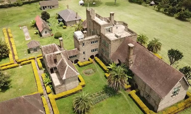
Egerton Castle. Construction was from 1938 to 1954. The castle was opened to the public in 2005 and is under management from Egerton University.
The castle has 52 rooms, which include: a dance hall with an electric organ (organ falling apart with missing keys, a hall lined with photos, and cabinets full of old electronics). It is in a state of disrepair – all the door knobs and electric switch plates are gone, the parquet floor broken, the walls dirty, and the furniture gone (except for the organ and a disintegrating bed). There are some lovely rooms with great windows. Stairs lead to the roof.
Maurice Egerton courted an English lady named Victoria and was keen to settle with her. The lady however turned down his proposal on account of what she referred to as a dwelling not befitting of her taste and standard. This prompted Maurice Egerton to construct the imposing castle in 1938 supposedly to impress the lady, who for the second time turned down his marriage offer and left for England. With this humiliation, a distraught and angry Lord Egerton made a monumental resolution: never to engage women in his life and never to marry. No woman was to be allowed into his home for whatever reason. His friends and farm workers were compelled to leave their wives or girlfriends at the gate. Egerton stayed in the castle for only four years until he died in 1958 aged 83 years. 1500KS (foreigners). I refused to pay this and eventually paid 500, still probably too much.
The drive from Nakuru was a nightmare of traffic. The large trucks were going about 25km/hr, the trucks overtaking them at 30km/hr, and many did not follow lane rules about speed. Add all the traffic from the motorcycles that don’t use the shoulder, the many share vans that drive fairly slowly, and people selling fruit blocking the centre. I drove extremely aggressively utilizing every passing opportunity.
There was an obvious speed trap – with no town, there was a 50km/hr sign (I didn’t see it) and I was pulled over. I asked for the radar reading and he produced an image that I was going 74. The only thing that ended the discussion was “I don’t have any money, or Mpeza (he asked for that) and only a credit card”. Instead of the $50 fine, I paid 500KS (about $4.50) and he accepted the obvious bribe.
At a large intersection (Tot Mau Summit), most of the trucks turned and faster driving was possible. I love this aggressive driving. Only one other car was driving at my speed.
ELDORET (pop 475,716) is a principal town in the Rift Valley region at an elevation of 2,100 metres (6,900 ft). It is currently the fastest-growing town in Kenya.
Airports: Eldoret (EDL)
Sacred Heart of Jesus Cathedral. Round with a roof sloping up to behind the altar and no columns, there were 4 sets of pews in a semicircle.
Just after leaving the church, my phone went dark and required the SIM card pin, then the PUK. I had pulled off to the side and traffic could pass me. A cop wanted to arrest me for stopping in the road. I argued a lot, refused to let him get in the car to drive to the police station (and couldn’t access Maps to get to it) and he finally let me leave.
I had to stop at 2 Sararicom offices to finally fix the issue. The issue was that the clerk I bought Mpeza from inserted a different SIM, eventually blocking my original PIN. After 90 minutes, I had one SIM, and one phone number, I could use Mpeza and had data.
I had planned on driving past Eldoret, but it was getting close to 5 pm, so ended up getting a hotel here. I ate at a KFC.
The Marakwet Escarpment (Elgeyo Escarpment) Furrow Irrigation System (12/02/2010). The furrows are located on the Marakwet escarpment in Elgeyo Marakwet district in the Kerio Valley of Kenya. The valley floor, lying at 1200-metre altitude, is traversed by the Kerio River flowing north towards Lake Turkana. The Marakwet escarpment rises some 1500 meters above the valley floor. Streams descending the Marakwet escarpment supply water to the irrigation furrows. There are two permanent rivers, the Arror in the south and the Embobut further north at a place called Tot. Irrigation occurs along more than 40 kilometres of Marakwet Escarpment from south of Arror north to Tot, on the western side of the Kerio Valley in Northern Kenya, and on the northern slopes of the Cherangani plateau in Pokot.
The art of using water furrows for irrigation is an old one for the Marakwet, dating to their initial occupation of the area in the Kerio Valley. The technology of furrow construction is complex; it involves the use of trunks, wood and stones lain on top of each other and with the support of mortar and leaves. From their sources, furrows follow weak or lower points passing through hills and valleys.
Due to the scarcity of water, the inhabitants of the area have over the years developed land use systems based on their perception and knowledge of the fragile ecological base. They started to rely on irrigation using the different perennial rivers fed from the Cherang’any Hills. To reconcile the competing demands for water use, the Marakwet evolved a unique technique of managing water rights that took into consideration the needs of each clan. This water management system operates on non-bureaucratic principles that ensure that the furrows not only provide water not only for human and animal consumption but also for irrigation.
According to the traditions, furrow works are communal. In case of shared furrows like Karamwar and Kapchemutta, there are guidelines for sharing. The Kamariny and Karamwar clans share their furrow on an annual basis. For instance, the Kamariny have it this year while the Karamwar have it next year. During a clan’s tenure, its members do virtually all the work on the maintenance, unless an emergency occurs that needs the other clan’s attention.
This is accessed just NE of Eldoret.
ON New Green Pastures Guest House, Eldoret. 1200KS. A simple room with a balcony and ensuite and very cheap. No breakfast. I rated it all 10s, the lady was so nice – she bought up a kettle and made sure my car was parked in a secure garage.
I turned on the TV – almost all the channels were religious. What a bunch of crap.
==============================================================
Day 5 Fri Apr 14
I was off at 7 for a long driving day.
KENYA – NYANZA and WEST (Kisumu, Kakamega, Migori, Bungoma)
Borders: Kenya-Tanzania, Kenya-Uganda
Nabuyole Falls. The road here was awful for about 5 km, I parked across the valley and saw the falls rather than continuing down to the valley bottom on this road. The falls go through a rocky area forming three braids.

The Kakemega Forest (12/02/2010) is a tropical rainforest, Kenya’s only tropical rainforest and is said to be Kenya’s last remnant of the ancient Guineo-Congolian rainforest that once spanned the continent. It is at 1500 and 1600 meters elevation in the watershed of the Isiukhu and Yala rivers, which flow through the forest before emptying into Lake Victoria.
It spans 238 square km with less than half of which currently remains as an indigenous forest. It is very wet, with an average of 1200 mm – 1700 mm of rain per year. Flora found in the park include some of Africa’s greatest hard and soft woods: Elgon teak, red stinkwood, and several varieties of croton, with a total of 150 species of trees and shrubs, and 170 species of flowering plants including 60 species of orchids. The forest is famous for its birds with 367 bird species, at least 9 birds are not found anywhere else.
Many local inhabitants rely on the forest to supply important resources, such as firewood, building poles and traditional medicines. Cattle grazing occurs in some of the glades.
The well-known Mama Mtere tree is a historic tree and the most photographed tree in Kakamega forest. There is forest walking, camping, hiking, primate watching, bird and butterfly watching, game watching and village walks.
There were many baboons (unfortunately being fed) on the road through the park.
Kenya Equator Monument. The second time I crossed the equator in Kenya.
KISUMU. The major town of the west, on the shore of Lake Victoria
Airports: Kisumu (KIS)
Kisumu Museum. The main exhibition hall has glass cases with stuffed animals, traditional medicine, metalwork, weapons, food prep, agriculture (blood + milk), ethnic groups, minerals and many stuffed heads. In a different building, is an aquarium – tiny with mostly small Lake Victoria fish, dark, labels missing. The Luo Homestead shows a grouping of one polygamous family and their son’s houses and grain storage. A local group put on a great dance and singing show. The snake house had several African snakes most venomous. 500 KS (payable only by mpeza)
I had lunch at Java House, a good Kenyan restaurant and then drove 162 km – 3 1/2 hours to Thimlich Ohinga. As detailed below, approaching this site from the west is the wrong way to go, a disaster of eroded roads, and huge ruts that were bypassed by driving into the woods.
Thimlich Ohinga Archaeological Site WHS. Situated 46 km northwest of the town of Migori, in the Lake Victoria region, this dry-stone walled settlement was one of the first pastoral communities in the Lake Victoria Basin, which persisted from the 16th to the mid-20th century. The term Thimlich is derived from a local Luo community phrase referring to a scary jungle. Ohinga is a form of earth/dry stone built settlement enclosure. The entire complex measures 21 hectares and has three enclosures, but only one is visited. The Ohinga, served as a defensive fort protecting the communities and livestock from wild animals and rivalry for land by competing immigrants but also defined social entities and relationships linked to lineage. Thimlich Ohinga is the largest and best preserved of these traditional enclosures. It acquired Luo names during its occupation in the 17th century. The Bantu people present were either assimilated or forced to move elsewhere. It was completely abandoned in the early 20th century when inter-clan conflicts and land demands ended. Nearby families continued to use the enclosure for livestock and cultivation.
The dry stone wall enclosures are constructed in a three-phase design with separately built-up outer and inner phases, held together by the middle phase. Stones of various sizes were placed in an interlocking system that enhanced overall stability without use of any mortar or cement. The main outside wall is an impressive 3.5 m to 4.2 m high, with an average thickness of 1 m except at the main gate where they were 3 metres thick. Small stone ramps lead up to the top of the walls. The six inside enclosures used for livestock have 1.5 m high walls. There were adobe-type houses with thatch roofs but there is no evidence of these anymore.
Luo culture characteristically had only one family living in the complex – 5 brothers, their many wives (one had 12 wives) and children.
Outside is a typical Luo homestead with buildings for men, each wife, the oldest son and food storage for each. 500 KS.
I put my name in the guest book – there had not been a visitor here since March 8 (ie over 2 months). The dates of previous visits were 6/03, 27/02, and 14/02, several visits in November – on the 3rd, 10th, 11th, 16th, and 19th, and then none previously until August on the 24th and 30th. Not many people are that interested in WHS and make the onerous drive to a very out-of-the-way place.
 au Kenya, en Afrique")
 au Kenya, en Afrique")
 au Kenya, en Afrique")
The “guide” who showed me the site, was not the shiniest penny. There was a large succulent with a “normal” tree base and a huge mass of several succulent branches, common in Kenya. I asked him what kind of tree it was and he said “cactus”. Its scientific name is Euphorbia bussei Pax and its common name Balsam Spurge. This species is native to eastern Tanzania and Kenya. It grows on rocky slopes and in sandy soils in deciduous forests at elevations from 1,150 to 3,280 feet (350 to 1000 m), It is a succulent tree with a cylindrical naked trunk and curved ascending branches that form a rounded crown. It grows up to 50 feet (15 m) tall. The trunk is thick, up to 12 inches (30 cm) in diameter, with grey fissured bark marked with usually six vertical rows of persistent spines and scars from fallen branches. The branches are 3– to 4-angled, up to 16.4 feet (5 m) long, deeply winged, and constricted into ovate to subcircular segments. The rudimentary leaves are ovate and scale-like. Spine shields with a pair of robust spines form a continuous horny margin along the angles. The spines are up to 0.8 inches (2 cm) long.
Getting here was not clear. I came from the West – and that is not the way to come. Google Maps gives several options from this direction and I took the longest one approaching from the south. The last 8 km was a disaster of eroded dirt, huge holes, and massive ruts. It required a high-clearance vehicle and AWD helped.
When I left, I took the road to the east. It was 14 km of rough rocky road with only a few washed-out areas, then 14 km on good pavement to the main highway at the town of Uriri (15 km from here to Migori and 7.1 km to Stalah). This is the only way to come.
About 5 km from Thimlich Ohinga, I got a flat. I could find the jack but not the spanner or key for one of the bolts. I called the rental company and was prepared to sleep the night there. It was raining very hard and got soaked. Various locals came by and one of them (the only one who spoke good English) was very handy. He searched the side pocket where the jack was and found the spanner and tool pouch with the key (I had felt all over and amazingly missed it all – I felt like a fool). He sent someone back to the village to get a large crescent wrench to use the jack, changed the tire for me and I gave him 2000KS, a great deal. He was very happy for his 30 minutes work but got pretty dirty in the process.
ON Nereah Hotel, Satalah. The closest hotel to Thimlich Ohinga. 1500 KS. I had a club sandwich for dinner (it must have taken an hour to make). The fries were stale and I ate none. She couldn’t understand that heating them up in a microwave would not bring back the crispiness necessary for good French fries.
I didn’t see
Tentative WHS: The Mfangano-Rusinga Island Complex (12/02/2010).
Mfangano-Rusinga Island complex is located in Lake Victoria, semi-arid to semi-humid type. Vegetation is thick forest trees and shrubs down slope, while the hilltop is dominated by patches of forest and grassland. Abasuba people, a sub-tribe of the Bantu provided refuge from the Luo people. Mfangano Island is known for its ancient rock art sites
Rock painting sites. 2,000 years old created by the Twa people, also known as Batwa or pygmies. Sets of concentric circles in two or all three of the colours red, white and black. Kwitone rock art. 40-metre long overhang just below a high shoulder on Stone Hill Wagimbe clan (Abasuba). Alternating red and white concentric circles, some with “spokes” between the two outer circles and concentric ovals.
Mawanga rock art panel eight square metres, consists of sets of concentric circles, mainly white and black with visible images superimposed upon each other. The wall and roof at the back have spectacular natural cupules. Paintings represent shields with special rainmaking powers.
Sacred sites in Mfangano Island. 36 sacred sites – 19 are still intact and can be located. Linked to rain-making traditions that warn the people of the impending danger, Appease the spirits through offerings of animal sacrifices. Local people – Abasuba.
Rusinga Island. Fossils, the skull of ‘Proconsul Africanus’ found here by anthropologist Mary Leakey. This anthropoid ape lived on the island three million years ago.
100 species of bird, giant monitor lizards, rock art sites
Islands: Mfangano, Rusinga. M@P Mfangano island
XL: Mageta island
==============================================================
Day 6 Sat Apr 15
I was up again at 04:30. I was able to get hot water for coffee and had BF in my room. The drive to Lake Elementaita was 5 1/2 hrs and 280 km. In Rongo, I stopped at a tire repair shop. The damage was to the side wall, I imagine from hitting a rock in the bad road to Thimlich Ohinga, He did an excellent repair, patching the inside, stuffing rubber tubing into the hole, adding a thick rubber patch to the outside and heating the whole thing under pressure for 30 minutes. It took an hour in total. 2500KS.
It was 2 1/2 hours to Kericho, my first stop.
KERICHO
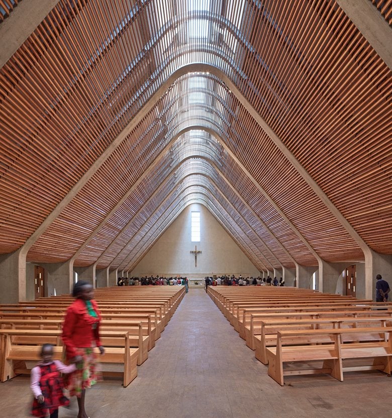
Sacred Heart Cathedral. Wow, don’t miss this modern church with its large space created by a hip-shaped roof and precast concrete beams. It seats 1500. The highlight is the Ways of the Cross, easily the best in the world – large single sheets of glass with bas-relief figures, most yellow. There is also a nice stained glass window backing the altar. The 2 doors each have four bas-relief Bible scenes. Outside a large wall covered with a mosaic of Adam and Eve and a very high square bell tower.
As I always steal my photos from the web, there was not one of the W of the C!!!
The drive here and departing had the best scenery in Kenya – the Central Highlands are a rolling vista of trees and tea plantations. The highway out of town was gorgeous – wide, shoulders the same level as the pavement, and very fast.
KENYA LAKE SYSTEM in the GREAT RIFT VALLEY WHS. Comprises three inter-linked relatively shallow lakes (Lake Bogoria, Lake Nakuru and Lake Elementaita) in the floor of the Great Rift Valley where major tectonic and/or volcanic events have shaped a distinctive landscape in a total area of 32,034 hectares. All three lakes are shallow, and alkaline and are hydro-geologically connected through sub-surface seepage of water. The alkalinity of the three lakes supports the abundant growth of the green algae (spirulina platensis) which is the food of the lesser flamingoes.
It is home to 13 globally threatened bird species and some of the highest bird diversities in the world. It is the single most important foraging site for the lesser flamingo. For most of the year, up to 4 million Lesser Flamingos move between the three shallow lakes in an outstanding wildlife spectacle. Surrounded by hot springs, geysers and the steep escarpment of the Rift Valley Also a major nesting and breeding ground for great white pelicans. The property features sizeable mammal populations, including black rhino, Rothschild’s giraffe, greater kudu, lion, cheetah and wild dogs.
Lake Elementaita. Lake Elementaita is situated 100 Km NNW of Nairobi at an altitude of 1670 metres ASL. It is fed by hot springs at its southern end and two small streams; the Mereroni Kariandusi and Mbaruk flowing from the Eastern plateau. The surrounding landscape is characterized by rocky faults, volcanic out crops and cones. To the east, the lake is flanked by small-scale agriculture while Ututu and Soysambu wildlife conservancies surround the remainder.
Lake Naivasha Tentative WHS (16/08/1999) is a freshwater lake north west of Nairobi. It is part of the Great Rift Valley. It is at the highest elevation of the Kenyan Rift valley at 1,884 metres (6,181 ft) in a complex geological combination of volcanic rocks and sedimentary deposits. There is no visible outlet.
It is surrounded by a swamp which covers an area of 64 square kilometres (25 sq mi), but this can vary largely depending on rainfall. The lake has an average depth of 6 metres (20 ft), 400 birds and many hippos.
Floriculture forms the main industry around the lake. However, the largely unregulated use of lake water for irrigation is reducing the level of the lake and is the subject of concern in Kenya. Fishing in the lake is also another source of employment and income for the local population. The lake varies in level greatly and almost dried up entirely in the 1890s. A series of devastating human pressures, the vast horticulture and agriculture industry and inflows of nutrients from siltation, sewage and other effluents emanating from a lakeside human population now approaching a million people.
NAIVASHA (pop 198,000) is a town, 92.8 km (57.7 mi) northwest of Nairobi. From 1969 the population expanded by a factor of 17 times.
The Maasai people from Sudan were the first group to settle on the basin due to their quest for pasture and water for their livestock in the 15th century. In the 16th century, the Bantu people migrated from the Central African forests. European settlers arrived in the 19th century.
In the late 1970s–1980s Lake Naivasha was overrun with poachers and foreign fish were introduced into the lake to provide fishing and by the local rose industry. The main industry is agriculture, especially floriculture.
Naivasha is also a popular tourist destination. Hell’s Gate National Park (the main location for The Lion King. Tours of Lake Naivasha observe birdlife and hippopotamus.
KWSTI Museum. Opened in 1985 as Naivasha Wildlife and Fisheries Training Institute.
LODWAR In the north on the main route to South Sudan with access to Lake Turkana
Christ the Redeemer Statue
Amboseli NP – a swampy lowland Masai park that is one of the best places anywhere in Africa to view large mammals
Central Island NP
Hell’s Gate NP – a small National Park close to Nairobi, which allows you to get out of the car and offers some nice opportunities for rock climbing and some game
Lake Bogoria National Reserve
Masai Mara National Reserve – probably the most popular reserve in Kenya due to the high concentration of large cats
==============================================================
Return to Nairobi and Central
The road climbed out of the Rift Valley giving gorgeous views of huge swaths of valley with its lakes and volcanoes. The views continued intermittently as the drive followed the edge of the escarpment. Initially, the road was two-lane but turned into a four-lane divided highway with high speeds into Nairobi.
The Hub Karen Mall. A lovely upscale mall surrounding open lanes and a courtyard. There is a Decathlon and a Burger King.
Karen Blixen Museum. The house with the museum is a lovely 1-story bungalow of grey stone with many windows. See original furniture, the lovely wood dining room and the outside kitchen on a guided tour. 1200 KS
Karen Blixen. Baroness Karen Christenze von Blixen-Finecke (born Dinesen; 17 April 1885 – 7 September 1962) was a Danish author who wrote works in Danish and English. Blixen is best known for Out of Africa, an account of her life while living in Kenya, and for one of her stories, Babette’s Feast, both of which have been adapted into Academy Award-winning motion pictures. Blixen was considered several times for the Nobel Prize in Literature, but it wasn’t awarded because judges were reportedly concerned about showing favouritism to Scandinavian writers,
Karen Dinesen was born in Rungstedlund, north of Copenhagen. After conceiving a child out of wedlock with his maid, her father was devastated because he broke his promise to his mother-in-law to remain faithful to his wife. He hanged himself on 28 March 1895 when Karen was nine years old.
She first fell in love with the dashing equestrian baron Hans Blixen-Fineckes, but he did not reciprocate. She therefore decided to accept the favours of his twin brother, Baron Bror Blixen-Finecke, they were engaged in 1912, and They decided to go to Kenya to start a coffee farm.
Life in Kenya, 1914–1931. They married in 1914. The Karen Coffee Company was established at Mbogani, near the Ngong Hills to the southwest of Nairobi – 6,000 acres, 600 acres for coffee. The land was not well-suited for coffee cultivation, given its high elevation. Bror had little interest in the farm and Karen ran it. Blixen and her husband were quite different in education and temperament, and Bror Blixen was unfaithful to his wife and had a legendary indiscipline when it came to money and honouring his debts. She was diagnosed with syphilis but her medical records do not support that diagnosis. She had been locally prescribed mercury and arsenic, and it is now believed that some of her later symptoms were the result of heavy metal poisoning.
She returned to Denmark in June 1915 for treatment. Back in Kenya, she met Denys Finch Hatton (1887–1931), Bror and Karen were separated in 1921 and she developed a long-term love affair with Hatton. She divorced in 1925, and Hatton moved into her house and began leading safaris for wealthy sportsmen. Among his clients was Edward, Prince of Wales. On safari with his clients, he died in the crash of his de Havilland Gipsy Moth biplane in March 1931.
With the failure of the coffee plantation, as a result of mismanagement, the height of the farm, drought and the falling price of coffee caused by the worldwide economic depression, Blixen abandoned her estate, the land was sold to a residential developer, and Blixen returned to Denmark in August 1931.
Her second book, now the best-known of her works, Out of Africa, was published in 1937. Its success firmly established her reputation. The most famous tale from Anecdotes is “Babette’s Feast”, about a chef who spends her entire 10,000-franc lottery prize to prepare a final spectacular gourmet meal. The story evaluates relationships and examines whether the austere but charitable life led by the sisters, in adherence to an ideal, is less true to the faith.
When Blixen was diagnosed with syphilis in 1915, she was treated with 1 gram of mercury per day for almost a year and also arsenic. By 1931, Blixen was suffering from anemia, had jaundice and had overused arsenic. As clumps of her hair had begun to fall out, she took to wearing hats and turbans. Extensive tests were unable to reveal evidence of syphilis after 1925. Her writing prowess suggests that she did not suffer from the mental degeneration of the late stages of syphilis. Blixen took strong laxatives “during her whole adult life”, which after years of misuse affected her digestive system. She also was a heavy smoker. By her seventies and in poor health it was concluded that the cause of her chronic pain and ailment was likely heavy metal poisoning. Unable to eat, Blixen died in 1962 at Rungstedlund, her family’s estate, at the age of 77, apparently of malnutrition.
Oloolua Nature Trail, Very near the museum, it goes to a waterfall, bamboo forest and a swamp.
Giraffe Manor Hotel. In the NM Hospitality Legends, Zoos and Well-being series, this 5-star luxury hotel has only 12 rooms. A highlight is the Rothschild’s giraffes that visit you for breakfast and rooms and eat out of your hand. Rates for one night are a family of four $3500, a single $1200/night. It was under renovation and closed. I stopped at the gate and learned that one had to apply for a special clearance to visit the hotel (all understandable in view of its exclusivity). I was able to peer around the gate and at least see the grounds.
Shri Swaminarayan Mandir. A Hindu temple devoted to Swaminarayan, it is a dramatic highly decorated building with 5 towers, 2 elephants out front and an over-the-top “altar of 10 highly coloured red figures under a bright gold “canopy. The interior is all carved dark wood – columns and coffered ceiling.
Kariakor Market. I entered at the small entrance on the front where all the guys are cutting up large rubber tires. Inside was a warren of tiny shops cutting leather and rubber to make sandals and shoes. I only saw this part but it is much larger with a wide range of goods and handicrafts.
Wakaluma Market. Another huge market surrounded by a high wall – multiple narrow lanes with a plethora of goods, but no manufacturing. The outside was a morass of people and produce sellers.
Westgate Shopping Mall. An upscale 4-story mall surrounding a large central “courtyard”. The food court was on the second floor (I ate at a Pizza Hut).
It is famous for the Sept 2003, Westgate massacre when four Al Shabaab gunmen detonated grenades and shot about 77 people in retaliation for the Kenyan army’s attacks on Somalian terrorists.
ON YWCA Parkside Suites. Returning to the same hostel, but this time with a microwave to heat water for coffee. A window could not be closed and the mosquitoes tormented me.
==============================================================
Day 7 Sun Apr 16
KENYA – COAST (Mombasa, Malindi, Lamu)
Borders: Kenya (sea border/port), Kenya-Tanzania
I had tried to book the train to Mombasa but could not finish the transaction. The 8 am train that makes 6 stops (6 hours) was sold out as were the first class seats (3000 KS) on the 3 pm express train (5.5 hours). By the time I pursued the train booking, the economy seats (1000 KS) also were sold out.
That turned out to be a lucky break as flying to Lamu was a much better choice.
Flight Safarilink Airways NBO-Lamu @ 14:15-16:15, 8800 KS. I took an Uber to Wilson Airport for 600 KS. I ended up sitting next to a lovely woman from Malindi who runs a non-profit organization for women with fistulas. I eventually FB-friended her.
Manda Airport is located on Manda Island – 450 km by air, southeast of Nairobi and is served by Air Kenya, Safari Link and Fly 540. There are daily flights to Malindi, Mombasa and Nairobi.
I took a small “ferry” boat from the Lamu Airport over to Lamu town for 200 KS and was met at the ferry by a local guide who had been given my name by the hotel.
LAMU
Lamu Town is a small town on Lamu Island, which in turn is a part of the Lamu Archipelago 341 km by road northeast of Mombasa that ends at Mokowe Jetty, from where the sea channel has to be crossed to reach Lamu Island. It is a UNESCO World Heritage Site. The town contains the Lamu Fort on the seafront, constructed under Fumo Madi ibn Abi Bakr, the sultan of Pate, and was completed after his death in the early 1820s. Lamu is also home to 23 mosques, including the Riyadha Mosque, built in 1900, and a donkey sanctuary.
History. It is Kenya’s oldest continually inhabited town and was one of the original Swahili settlements along coastal East Africa. It is believed to have been established in 1370. Today, the majority of Lamu’s population is Muslim (90%).
In 1506, the Portuguese fleet under Tristão da Cunha sent a ship to blockade Lamu, a few days later the rest of the fleet arrived forcing the king of the town to concede to pay an annual tribute to them with 600 Meticals immediately. The Portuguese action was to control trade along the coast of the Indian Ocean. For a considerable time, Portugal had a monopoly on shipping along the East African coast and imposed export taxes on pre-existing local channels of commerce. In the 1580s, prompted by Turkish raids, Lamu led a rebellion against the Portuguese. In 1652, Oman assisted Lamu in resisting Portuguese control.

Lamu Fort
“Golden Age”. Lamu’s years as an Omani protectorate during the period from the late 17th century to the early 19th century mark the town’s golden age. During this period, Lamu became a centre of poetry, politics, arts and crafts as well as trade. Many of the buildings of the town were constructed during this period in a distinct classical style. Lamu became a literary and scholastic centre.
In 1812, a coalition Pate-Mazrui army invaded the archipelago. During the Battle of Shela. they were violently suppressed by the locals in their boats on the beach as they tried to flee. In fear of future attacks, Lamu appealed to the Omanis for a Busaidi garrison to operate at the new fort and help protect the area from Mazrui rebels along the Kenyan coast.
Colonial period. In the middle of the 19th century, Lamu came under the political influence of the sultan of Zanzibar. The Germans claimed Wituland in June 1885 and considered Lamu to be of strategical importance and an ideal place for a base. From 1888 to 1891, there was a German post office in Lamu, the first post office to be established on the East African coast. In 1890, Lamu came under British colonial rule. Kenya gained political independence in 1963, although the influence of the Kenyan central government has remained low, and Lamu continues to enjoy some degree of local autonomy.
Modern Lamu. Two attacks in the vicinity of Lamu in July 2014, for which Al Shabaab claimed responsibility, led to the deaths of 29 people.
Climate. Lamu has a tropical dry savanna climate.
Economy. Lamu’s economy was based on the slave trade until abolition in the year 1907. Other traditional exports included ivory, mangrove, turtle shells and rhinoceros horn, which were shipped via the Indian Ocean to the Middle East and India. In addition to the abolition of slavery, the construction of the Uganda Railroad in 1901 (which started from the competing port of Mombasa) significantly hampered Lamu’s economy.
Tourism has gradually refuelled the local economy in recent times, and it is a popular destination for backpackers. Many of the locals are involved in giving trips on dhows to tourists. Harambee Avenue is noted for its cuisine, and has a range of stores including the halwa shop selling sweet treats and miniature mutton kebabs and cakes are sold at night. Coconut, mango, grapefruit and seafood such as crab and lobster are common ingredients. The town contains a central market, the Gallery Baraka and Shumi’s Designs shop, and the Mwalimu Books store.
Mangroves are harvested for building poles, and Lamu has a sizeable artisan community, including carpenters who are involved in boat building and making ornate doors and furniture.
Maulidi Festival. Held in January or February, it celebrates Mohammed’s birth with pilgrims from Sudan, Congo, Uganda, Zanzibar and Tanzania joining the locals to sing the praise of Mohammad.It features a range of activities from “donkey races to dhow-sailing events and swimming competitions”.
Lamu Cultural Festival, a colourful carnival is usually held in the last week of August, with traditional dancing, crafts including kofia embroidery, and dhow races.
The Donkey Awards in March/April give prizes to the finest donkeys.
Women’s music in the town is also of note and they perform the chakacha, a wedding dance. Men perform the hanzua (a sword dance) and wear kanzus.
Lamu Museum. Across the street from where the ferry docks, I saw this immediately off the boat. The bottom floor gives a great history of Lamu and its Swahili inhabitants. Oddly, the top floor was all about Oman (who had funded the museum) and it seemed very out of place. 500 KS.
The “guide” took me to the hostel but was rather disappointed that I didn’t hire him to guide me around Lamu. I am a little disappointed that the hostel gave him my name as it puts one in a difficult position. The guide was very nice, 72 years old with 7 children and I’m sure needs the business.
As it was still Ramadan, I left the hostel after 6 pm, bought some groceries and ate at a local restaurant (chicken biryani) on the waterfront.
I sat on the very top of the hostel (5th floor?) where there was a cool breeze and chatted for a long time with a law student from Nairobi doing an internship. She is from South Sudan originally, very tall and thin and Dinka. She enjoyed my photos of the cattle camp.
ON Wildebeest Hostel. US$15, In the middle of the warren of tiny lanes of Old Town Lamu (turn at the watermelon stand and follow the drains, turning right at the always-on LED light, I checked in and got a room at the top of the 5-story house. The hostel was more confusing than the lanes with many turns and stairways – I would bet that you could never find my room.
I was awoken at 04:30 and 5 am by the very loud call to prayer.
Day 8 Mon Apr 17
Up early, I had coffee and cereal. It rained so I worked on this and left to walk the 40 minutes to Shela Beach.
Lamu has two “streets” – 1st street is the one next to the water and the second street is up a short block, totally pedestrian and a few metres wide with many shops. Narrow lanes about 1.5 m wide extend up into the town. I went to the fort (entrance included in the museum ticket), and the mosque and then continued down 2nd street to the end of Old Town. People were sweeping up the garbage and donkey poo and cleaning the open sewer that runs everywhere besides the lane. Here donkeys are common, roaming free and more often ridden than carrying freight. One gets constant offers to guide you through the town.
At the end of town, it was rather depressing with a lot of garbage.
Lamu Old Town WHS. Lamu Old Town, located on an island 350km north of Mombasa is the oldest and best-preserved Swahili settlement in East Africa, retaining its traditional functions. Built-in the best Swahili building technology in coral stone and mangrove timber, the town is characterized by inner courtyards, verandas, and elaborately carved wooden doors. Lamu has hosted major Muslim religious festivals since the 19th century and has become a significant centre for the study of Islamic and Swahili cultures as illustrated by the annual Maulidi festivals.
The core collection of buildings is influenced by Bantu, Arabs, Persians, Indians, and Europeans – covers 16 ha, still authentic. Important trade centre continuously inhabited for over 700 years. Narrow streets and magnificent stone buildings with impressive curved doors. The buildings on the seafront have arcades and open verandas. Internally decorated with painted ceilings, large niches (madaka), small niches (zidaka), and pieces of Chinese porcelain.
Narrow winding streets produce a labyrinth with origins in Arab traditions of land distribution and urban development. It is also divided into small wards (mitaa) each where many closely related lineages live.
At least 30% of the homes have been bought by Westerners (USA, England and Europe) which has inflated the housing costs and sits empty most of the year.
Once a centre for the slave trade, the population of Lamu is ethnically diverse. Lamu was on the main Arabian trading routes, and as a result, the population is largely Muslim.
Lamu Fort. Fumo Madi ibn Abi Bakr, the sultan of Pate, started to build the fort on the seafront, to protect members of his unpopular government. He died in 1809 before the first storey of the fort was completed. The fort was completed by the early 1820s. It is a large structure with high walls, a big round tower on the SW corner and towers on each of the front corners. Walk up the steps and enter a large courtyard with a veranda running around three sides. There is nothing to see and no exhibits. 500 KS is included in the museum fee so keep your ticket for that to show at the entrance.
Riyadha Mosque. Habib Salih, a Sharif from Comoros Island built the mosque in 1900. After he died in 1935, his sons continued the madrassa, which became one of the most prestigious centres for Islamic studies in East Africa. The Mosque is the center of the Maulidi Festival.
Fronted and to the side of a large square, this small mosque is white with green accents and a yellow crenellated roof line. Surprisingly I could not see a mihrab. Guys were sleeping on the floor.
Donkey sanctuary. Since the island has no motorized vehicles, transportation and other heavy work is done with the help of donkeys. There are some 3000 donkeys on the island and the Sanctuary was opened in 1987 to provide treatment to all donkeys free of charge.

Dhows competition during the Lamu cultural festival 2012
Shela Beach. It is at least a 50-minute walk to the beach from the end of the old town, initially on a wide boardwalk, then a 1 m wide concrete path on the edge of the ocean wall and then soft sand above black basalt boulders. Shela is an upscale village with many nice guesthouses/hotels with gardens, arcades, columns and rooms ascending the hillside. Walk through the town to the beach, a long sloping, yellow sand beach with many boats and no sunbathers. I saw no one swimming. That was my initial plan (I even wore my swim trunks) but questioned the cleanness of the water as many drains were emptying onto the beach from the guesthouses.
I talked for about an hour with an American surgeon (Richard Davis) who had worked in Nairobi for 17 years teaching Kenyan surgeons. His three children had been raised here and all loved Kenya. He talked about the incredible scope of surgery and the challenge of learning new procedures (by reading about them). He has had an amazing, challenging and very fulfilling career functioning in third-world medicine. He was considering moving back to the US in 2026 and practicing there as all his children would be going to university there.
We talked a lot about Aspergers as he had a good friend who was a social disaster but unwilling to understand what his issues were.
This is another great example of talking to everyone you meet – you encounter the most interesting and amazing people.
I got a boda back to town for 100 KS, showered, went to eat lunch (all closed on Ramadan) and got the “ferry” over to Manda airport.
Flight Safarilink 052 Lamu-Malindi @ 15:55-16:15 6300KS
I was met at the airport by Habiba’s brother Lukman, taken to her house for dinner and stayed there (she lives with her brother and son). They are an extremely generous family. She lives in a giant 3 1/2-story house with a least 6 bedrooms each with an ensuite. The entire acre compound is walled with a very high wall.
After dinner, we went to the new construction of a small hospital she is building as part of a project to empower women. It is 4-stories and seems to have everything – she designed it in her head and directs construction through her very capable (and wonderful guy) brother.
MALINDI (pop 120,000) is a town on Malindi Bay at the mouth of the Sabaki River 120 kilometres northeast of Mombasa. Tourism is the major industry in Malindi. The city is popular among Italian tourists. The nearby Watamu resort and Gedi Ruins (also known as Gede) are south of Malindi. The mouth of the Sabaki River lies in northern Malindi.
The Watamu and Malindi Marine National Parks form a continuous protected coastal area south of Malindi. The area shows classic examples of Swahili architecture. The majority of Malindi’s population is Muslim. Malindi is home to the Malindi Airport, Sai Eden Roc Hotel and Broglio Space Centre (the previous San Marco Equatorial Range). It was the landing point of Vasco Da Gama in Kenya
Airports: Malindi (MYD)
ON Habiba Mohamed’s house, Malindi
Day 9 Tue Apr 18
A very relaxing day at Habiba’s house. It is Ramadan so they don’t eat or drink after 5 am and till after 6 pm, but I am free to eat whenever I like. We went out for a walk around the neighbourhood, truly out in the boondocks (her house has only a few houses in the visible distance but a few closed/abandoned resorts). It is a short distance to the beach where there were many fishermen in the water and in boats at low tide. She bought several fish.
I read the Economist and National Geographic and added several posts to my website.
ON Habiba Mohamed’s house.
Day 10 Wed Apr 19
Another quiet day. Washed clothes. Went out for lunch at an expensive restaurant on the beach with a visiting gynecologist here to advise her on her hospital.
I went with Lukman (Habiba’s brother) shopping for dinner. On the way back we went to the three NM sites in Malindi.
Malindi Museum. A reasonable regional museum with few things I had not seen before. 500KS
Vasco da Gama Pillar. More impressive for what it represents (the genesis of the Age of Exploration) than the edifice itself. Erected by the Portuguese explorer Vasco da Gama as a navigational aid in 1498, the coral column is topped by a cross made of Lisbon stone, which almost certainly dates from the explorer’s time. There are good views from here down the coast and out over the ocean. 500KS
Ndoro Sculpture Garden, In the NM Bizzarium series, this is the permanent outdoor sculpture garden of African art expert, journalist and gallerist Carola Rasmussen. It is in a beautiful tropical garden along Casuarina. Follow a winding path with about three hundred stone sculptures, almost all in “serpentine stone”, the African jade originating from Zimbabwe, a country that has a tradition of sculpting. It is inspired by Western sculptures and painters including Pablo Picasso. Rasmussen is a German of Danish origin who over forty years has collected sculptures from Zimbabwe.
The sculptures include faces, animals (elephants and nocturnal birds of prey), African symbolic and figurative art.
Ndoro Sculpture Garden can be visited only by appointment, by calling 0798461564 or by writing to [email protected]
We made meatloaf together plus mashed potatoes and glazed carrots. It is always difficult cooking in someone else’s kitchen with many missing ingredients and an oven that I’m not sure works well.
Day 11 Thur Apr 20
Up early, as usual, I finished business and Lukman kindly drove me to Gedi. I saw the ruins and butterfly house and he drove me back to the highway where I caught a mini-van (mutata) to Mombassa. 500KS
GEDE
The Historic Town of Gedi Tentative WHS:(12/02/2010). Gedi lies on the coast 94 km north of Mombasa. Gedi was a small Swahili town built entirely from rocks and stones dating to the 15th century. It has an area of 44 hectares with pillar tombs, the palace and a great mosque with two walls around it. The inner wall was where the rich lived. The outer wall enclosed 18 hectares which also included farm and plantation land with mud and wattle houses for the middle class. Outside the walls is where the peasants lived.
There is a dated coral tomb with a beautiful Arabic script engraved with the date 1399. The Great Mosque has a spectacular 50m deep well and an octagonal pillar tomb of the Imam or priest. Further into the forest is the 15th-century palace where the king held court and addressed women with marital problems. 35 hectares of coastal forest wind between the excavated buildings.
It is not quite clear why the town was eventually deserted, possibly it was invaded by an army from Mombasa on its way to attack Malindi around 1530 AD, or the Galla people who were raiding southwards around 1600 AD made life unbearable or the wells dried up. The nobles did not flee; they had time to empty their gold and precious stones in their secret vaults since none of this type of wealth had ever been found.
The ruins are well labelled and all in a small area. All are partial standing walls with no roofs. Outside the mosque and palace are very deep, wide wells bored into the rock. The mihrab in the mosque is lovely. 500 KS
Kipepeo Butterfly House. At the same entrance as the Gedi ruins, this has butterflies. 200 KS payable as a separate ticket.
All mutations are slow and crowded. There are many stops to let off and get new passengers. I eventually moved from the second row of seats to the middle front and then the left front as the guy took pity on me. 500 KS to Mombassa.
KILIFI
Mnarani Ruins are the remains of two mosques near Mnarani in Kilifi County. Dating from the 15th century, the mosques are located on a bluff overlooking Kilifi Creek from the southern side. The settlement at the site dates back to the 14th century, and the site also contains several tombs.
Mnarani was an Arab settlement in the 14th century. At that time, traders from Oman used to sail with the monsoon winds from the Persian Gulf to the Indian Ocean and land on the Kenya coast.
In less than a hundred years their business flourished and the Mnarani settlement became the residence of many of them, including fishermen and farmers.
Archaeological evidence shows that the site was eventually destroyed by the Galla in the early 17th century. The low water supply caused the Arabs to flee and settle in other Coastal towns. The ruins are at the top of 107 steps you must climb to get a spectacular view.
Among the ruins are remains of a large Friday (or congregational) mosque, a smaller mosque, parts of the town, a gate and several tombs dating to the 15th century. The Great Mosque, with its finely carved inscription in Persian (suggesting that the early settlers in Mnarani were Persians from Oman) around the mihrab with multiple arches and inscribed jambs. The foundations of the great and smaller mosque are all that is left. A dried-up 75-foot deep well. The monstrous old baobab trees on the edge of the bluff is a 900-year-old beauty. There is also a Museum and a snake park.
Dalton House, Kilifi. In the NM Architectural Delights, series, this house built in 20215 opens to the Indian Ocean and the mangroves below. The two stories are connected by a wide 9.9m wide stair. The lower courtyard has a small water pool, the living and dining room, the kitchen and the guest rooms. On the top floor are three small apartments. All carpentry, doors and windows are made of mahogany two inches thick and carved following a geometric pattern of the mosaics from the Alhambra Palace of Granada, Spain.


I was dropped off with a .8 km walk to my hostel.
I was driven to Java House for dinner and then had a 2.8 km walk back to the hostel.
ON Akogo Backpackers. 900 KS. It was a good bargain for the price with several other interesting travellers. The mosquitoes were bad until I applied DEET and wore my mosquito head net to bed.
Day 11 Fri Apr 21
Up early, I decided to go into the city (Mombassa Island). I got a boda to the market and then another to my hotel in a great location near all the sites of Mombassa. 500 KS total for bodas.
Kongowea Market. A huge market on the north side of the river and Mombassa Island. I has a large clothes section and a four-story building with produce.
MOMBASA (pop 1.21 million, metro 3,528,940) is a coastal city in southeastern Kenya along the Indian Ocean. It was the first capital of British East Africa before Nairobi was elevated to capital city status in 1907. The town is known as “the white and blue city”. Mombasa’s location on the Indian Ocean made it a historical trading centre, and it has been controlled by many countries because of its strategic location. Kenyan school history books place the founding of Mombasa as 900 A.D. It must have been already a prosperous trading town in the 12th century, as the Arab geographer al-Idrisi mentions it in 1151. The oldest stone mosque in Mombasa, Mnara, was built c. 1300.
In the late pre-colonial period, it was the metropolis of a plantation society, which became dependent on slave labour based around the ivory trade. Throughout the early modern period, Mombasa was a key node in the complex and far-reaching Indian Ocean trading networks; its key exports then were ivory, millet, sesamum and coconuts.
Today, Mombasa is a tourism-based town, home to one of the state houses, with an extra-large port and an international airport.
History. The famous Moroccan scholar and traveller Ibn Battuta (1304 – 1368/1369) visited the area during his travels to the Swahili Coast. He stayed only one night. He wrote that the people of Mombasa were Shafi‘i Muslims, religious people, trustworthy and righteous. Their mosques were made of wood, and expertly built.
The exact founding date of the city is unknown but probably 900 A.D. The Mandhry Mosque, built in 1570, has a minaret that contains a regionally specific ogee arch. This suggests that Swahili architecture was an indigenous African product rather than being adopted from non-African Muslims who brought stone architecture to the Swahili Coast.
During the pre-modern period, Mombasa was an important centre for the trade in spices, gold, and ivory. Its trade links reached as far as India (Cholas of South India), Persian Empire, the Arabian Peninsula and China.
Portuguese. Mombasa was under Portuguese rule from 1593 to 1698 and again from 1728 to 1729. Vasco da Gama was the first known European to visit Mombasa, receiving a chilly reception in 1498. Two years later, the town was sacked by the Portuguese – Tristão da Cunha in 1506, Afonso de Albuquerque in 1522, and finally the destruction of the city under Nuno da Cunha in 1528 after the Malindi sultan failed to pay tribute.
The Portuguese took over Mombasa a third time in 1589, and four years later they built Fort Jesus to administer the region. In 1631 Dom Jeronimo the ruler of Mombasa slaughtered the Portuguese garrison in the city
Omani rule. With the capture of Fort Jesus in 1698, the town came under the influence of the Imamate of Oman,
British rule and independence. In 1887 Mombasa was relinquished to the British East Africa Association, and a British administration in 1895. It soon became the capital of the British East Africa Protectorate and the sea terminal of the Uganda Railway, construction of which was started in 1896. Many workers were brought in from British India to build the railway, and the city’s fortunes were revived. The capital was moved to Nairobi in 1907 and has been Kenya’s capital since.
The Mombasa tusks, one of the city’s best-known monuments, were originally constructed in 1952 by the British administration of the Kenya Colony, commemorating the visit of Queen Elizabeth II to the city.
In 2018, all buildings in the Old Town and the Central Business District were painted white with Egyptian blue trim and banned all signs from their walls or canopies.
Geography. Being a coastal town, Mombasa is flat. The town of Mombasa is centred on Mombasa Island but extends to the mainland. The island is separated from the mainland by two creeks, Port Reitz in the south and Tudor Creek in the north.
Climate. Mombasa has a tropical wet and dry climate. The rainiest months are April and May, and minimal between January and February. Located near the equator, Mombasa has only a slight seasonal temperature variation, with high temperatures ranging 28.8 to 33.7 °C. Coastal erosion has become a problem for infrastructure due to rising sea levels – the coastline has been eroding at 2.5–20 cm (0.98–7.87 in) per year. This has increased the number of annual floods
The City. Mombasa is located on Mombasa Island and is separated from the mainland by two creeks: Tudor Creek and Kilindini Harbour and sprawls to the surrounding mainland. Mombasa has a cosmopolitan population, with the Swahili people and Mijikenda predominant.
Religion. Islam (37.3%), Christianity (56.4%)}|
Economy. In addition to the coffee trade, and the food and chemical industries, there is a steel mill, an aluminum rolling mill, an oil refinery and a cement plant. The city is home to the most important seaport in East Africa, Kilindini Harbor, which is also used by the neighbouring countries Tanzania and Uganda for their imports and exports. The channel is naturally very deep.
Mombasa is a centre of coastal tourism in Kenya. Mombasa Island itself is not a main attraction, although many people visit the Old Town and Fort Jesus. The Nyali, Bamburi, and Shanzu beaches are located north of the city. The Shelly, Tiwi, and Diani beaches are located south of Mombasa. Several luxury hotels exist on these beaches, while the less expensive hotels are located further away.
Mombasa’s northern shoreline is renowned for its vibrant 24-hour entertainment offers, including both family entertainment (water parks, cinemas, bowling, etc.), sports (water sports, mountain biking and go-karting), culinary offers (restaurants offering a wide range of specialties from Kenya, China, Japan, India, Italy, Germany and other countries) and nightlife (bars, pubs, clubs, discothèques, etc.).
Other local industries include an oil refinery with a capacity of 80,000 barrels (13 ML) a day, and a cement factory capable of producing over 1.1 million tons per year. The major intercontinental undersea telecom cables reach shore next to Mombasa, connecting the African Great Lakes to the rest of the world and supporting a fast-growing call centre business in the area. The estimated real GDP growth for Kenya in 2016 is 5.7-6.0%. This growth will be in response to the construction of a railway system from Nairobi to Mombasa which will aid in trade and transportation between Kenya’s two major cities.
Mombasa will become a Special Economic Zone (SEZ) in which certain industries such as tea, garments, and footwear will be exempt from certain taxes to promote domestic growth.
At 44%, the rate of youth unemployment in Mombasa is more than double the national average of 21% (2016).
Mombasa currently has a modern railway station on the Mombasa–Nairobi Standard Gauge Railway that replaced the narrow-gauge Uganda Railway completed in 1901 under British colonial rule. Completed in 2017 and located at Miritini, the Mombasa Terminus station links Mombasa to Nairobi. The station, situated about 20 km from the city centre, is accessible through the newly built (2018) highway, being the first phase of the Dongo Kundu bypass.
Transportation. Matatus (mini-buses) move around the city and its suburbs. The tuk-tuk is widely used. A boda-boda is originally a bicycle taxi but has long since been replaced by motorcycles.
Sea. The port of Mombasa is the largest in East Africa, with 19 deep water berths two additional berths nearing completion and two oil terminals. International cruise ships frequent the port. The port is part of the 21st Century Maritime Silk Road that runs from the Chinese coast to the Upper Adriatic region. In connection with the Silk Road Initiative, China has started infrastructure development projects in Kenya and is building roads, railways and public buildings on credit.
There is no bridge between Mombasa Island and the south coast, instead, the route is served by ferries operated by the Kenya Ferry Service from Kilindini and Mtongwe to Likoni in the south coast of Mombasa.
As a result of the increase in more luxurious hotels along the south coast and a lack of a direct bridge linking with Mombasa island, visiting tourists have the option of flying directly from Nairobi into the South Coast airstrip at Ukunda.
The Dongo Kundu Bypass Highway is currently (2018) under construction. With a total of three bridges, it will finally connect the mainland to the south coast easing the burden on the ferry services. Mombasa Gate Bridge will connect the mainland to Iikoni to eliminate the usage of the unsafe ferry which has claimed hundreds of lives.
Airport Mombasa (MBA)
Mombasa Memorial Cathedral. An Anglican cathedral, it has two bell towers and a large gold dome over the altar. On a Friday, it was closed.
Fort Jesus WHS. Built by the Portuguese in 1593-1596 to protect the port of Mombasa, is one of the most outstanding and well-preserved examples of 16th Portuguese military fortification. With an area of 2.36 hectares and includes the fort’s moat.
The fort was built in the shape of a man (viewed from the air) and is roughly square, with four bulwarks at its corners. The fort is considered a masterpiece of late Renaissance military fortification.
Fort Jesus was captured and recaptured at least nine times between 1631, when the Portuguese lost it to the Sultan Yusuf ibn al-Hasan of Mombasa, and 1895 when it fell under British rule and was converted into a prison.
First successful attempt by Western civilization to rule the Indian Ocean trade routes. Imposing walls, five bastions, African, Arab, Turkish, Persian and European fought to gain and maintain their control over this strategic port. 1200KS
Mandhry Mosque. A small mosque with two prayer rooms and a round conical minaret. One guy made a big issue out of me wearing shorts when others said it was fine.
Mombasa Old Town Tentative WHS:(26/06/1997). Situated on the southeast side of Mombasa Island, it covers 72 hectares and is inhabited by a mix of Swahili, Arab, Asian, Portuguese and British settlers.
Buildings in the Old Town are mostly Swahili, however, the many other ones are influenced by Mombasa’s trade culture and foreign occupation, with many examples of colonial Portuguese styles from the 16th century and modern Islamic architecture. Shri Mackinnon Market. In the old town, it is mainly clothes and shoes with many narrow lanes in one main building and many stalls in the surrounding streets.
Kutchi Satsang Swaminarayan Temple. Three stories with a tower and front door covered in bas relief colourful figures, the hall has several bas-reliefs showing protection against spirits, demons and yamduts (hellish people). Drinking alcohol will be punished by drinking hot boiling iron. The main hall has one wall of less severe stories in basrelief. Pembe Za Ndovu. On the 4-lan divided street (Moi Avenue) lining lovely Uhuru Park (full of birds singing and many people), this monument of sheet metal plates consists of two giant, curved tusks crossing over each side of the street. Two small elephants sit on the median.
The two tusks create the letter M – the first letter of Mombasa. Constructed by the British colonial administration, the giant tusks served as a commemoration of the historical visit to Kenya by Queen Elizabeth II in 1952. The original tusks were made of wood and canvas. The tusks were apparently to be removed after the visit but due to their proximity to Uhuru Gardens, this was shelved. In 1956, the Mombasa Municipal Council decided to rebuild the elephant tusks,” giving them a more imposing appearance by using aluminum, which made the monument weather resistant.

Holy Ghost Cathedral. An RC cathedral with two square bell towers. On a Friday it was closed.
Liwatoni Pedestrian Floating Bridge. 840 metres long and about six metres wide. it stretches from Liwatoni in Mombasa Island to Ras Bofu (Peleleza) in Likoni. It was designed to ease pressure on the Likoni ferry crossing by taking up most of the foot traffic, leaving the ferries to serve vehicular and cargo crossing between Mombasa Island and the South Coast. The bridge has a 150-metre movable section mid-ocean, to allow for opening and closing and ease the movement of ships in and out of the port. Tag boats open and close the movable part one hour before a ship passes. This allows sufficient time for withdrawing undersea gravity anchors. Pedestrians will have to wait for about an hour before crossing should there be a ship about to pass.
The Likoni channel ferries an estimated 300,000 passengers and over 6,000 cars daily.
.Sacred Mijikenda Kaya Forests. WHS The Mijikenda Kaya Forests consist of 10 separate forest sites mostly on low hills, ranging in size from 30 to around 300 ha spread over some 200 km along the coast containing the remains of more than 30 surviving fortified villages, known as kayas, of the Mijikenda people.
The kayas, created as of the 16th century but abandoned by the 1940s, are now regarded as the abodes of ancestors and are revered as sacred sites and, as such, are maintained as by councils of elders. The site is inscribed as bearing unique testimony to a cultural tradition and for its direct link to a living tradition.

The forest around the Kayas have been nurtured by the Mijikenda community to protect the sacred graves and groves and are now almost the only remains of the once extensive coastal lowland forest.
Since their abandonment as preferred places of settlement, Kayas have been transferred from the domestic aspect of the Mijikenda landscape to its spiritual sphere and the biodiversity of the Kayas and forests surrounding them has been sustained. The Kayas are under threat both externally and from within Mijikenda society through the decline of traditional knowledge and respect for practices.
The Eastern Arc Coastal Forests (Arabuko-Sokoke Forest and Shimba Hills National Reserve) Tentative WHS (12/02/2010). From the border with Somalia to the north to that with Mozambique to the south. Arabuko-Sokoke lies a few kilometres inland on the Kenyan coast, between the towns of Kilifi and Malindi and some 110 km North of Mombasa. The Shimba Hills are a dissected plateau that ascends steeply from the coastal plains, some 30 km southwest of Mombasa and just south of Kwale town. Remnants of the largest coastal forests in East Africa, birds, one of the twenty-five biodiversity hotspots in the world.
The forest has three main forest types: 1. mixed forest on white, very infertile soil, dense, tall and undifferentiated, with a diversity of tree species. Two areas of relatively tall Cynometra forest, 20 m, intermediate 7-8 m. The dry north-western part is low, dense, and often almost impenetrable Cynometra thicket (2,300 ha), 5 m high.
The Shimba Hills one of the few large areas on the south coast that was still well forested. grassland, scrub and exotic plantations as well as forest. Six major forest types, including tall Milicia forest on the deep soils on the plateau top (in Longomwagandi and Makadara forests, and near Kwale town), and on the western escarpment Afzelia Erythophoeum forest, covering much of the eastern and southern escarpment; Paramacrolobium forest on particular steep scarp slopes to both east and west; and Manilkara-Combretum forest in the lower, western sector of the plateau. The biggest single patch of forest is the south-western sector, including Mkongani North and West. Further east and north, the forest breaks up into a complex mosaic interspersed with scrub and grassland.
ON Duncort Hotel. At 2000KS and in the centre of the island’s downtown area, it was a great deal. No fridge but a mosquito killer.
Day 12 Sat Apr 22
I was up very early to catch the 05:30 bus (Tahmeed Bus lines, 9-12 hours, 586 km, 1700 KS) to Dar es Salam. Tahmeed is the only bus line giving daily service to Dar es Salam (5 and 5:30 am). I was very uncertain of the terminal location. I got a Bolt (300 KS) and the driver drove around to the back where the Dar es Salam bus leaves.
==============================================================
The only region of Kenya that I didn’t visit is the Northeast. It is considered dangerous because of terrorists. It is not possible to drive from Lamu to Malindi and one must fly. Similarly, the Lake Turkana area is a no-go zone.
==============================================================
SEE
Northern tribes living very traditional lifestyles – you can start to encounter these remarkable societies near to and around the main road North into Ethiopia (the A2 which runs through Marsabit and into Moyale at the Ethiopian border), as well as West of this in places such as Wamba, Maralal, Baragoi, Korr, Kargi, South Horr, etc.
Wildlife. Kenya has a considerable land area devoted to wildlife habitats, including the Masai Mara, where blue wildebeest and other bovids participate in a large-scale annual migration. More than one million wildebeest and 200,000 zebras participate in the migration across the Mara River.
The “Big Five” game animals of Africa, that is the lion, leopard, buffalo, rhinoceros, and elephant, can be found in Kenya and in the Masai Mara in particular. A significant population of other wild animals, reptiles, and birds can be found in the national parks and game reserves in the country.
The annual wildebeest migration occurs between June and September, with millions of animals taking part, attracting valuable foreign tourism. Two million wildebeest migrate a distance of 2,900 kilometres (1,802 mi) from the Serengeti in neighbouring Tanzania to the Masai Mara in Kenya, in a constant clockwise fashion, searching for food and water supplies.
Bookings to watch the migration are best done months in advance due to the high demand and limited lodging available in the Mara.
Game drive in the Nairobi National Park found less than 20 minutes drive from the Cental Business District. Major attractions, big cats including lions and leopards, buffaloes, a variety of antelope species, baboons, and monkeys amongst others.
Marafa Depression. The Marafa Depression is what’s left behind of a massive sandstone ridge that slowly eroded over time due to the harsh winds, rains, and floods that often hit this region, which is why the locals of Marafa call this geological wonder “Nyari” which means “the place broken by itself.” This canyon designed by the skillful hand of the elements is one of Kenya’s most unique geological sites, where vibrantly tinted rock layers and jagged gorges form a kaleidoscope of colours that illuminate the canyon during sunset, where intense shades of crimson, and orange, pink, and white come to life.
GET IN
By plane. Kenya Airways (KQ) is the national airline. Johannesburg, Harare, Cairo-Egypt, Entebbe, Accra. Dubai-UAE, London-UK, Amsterdam-Netherlands, Mumbai-India, etc). Kenya has four International airports: Jomo Kenyatta International Airport (NBO) in Nairobi. Moi International Airport in Mombasa, Kisumu International Airport Kisumu
By car. Roads are mostly in good condition accessible and paved in all but the most remote regions of the country, especially in the North Eastern Region. All neighbouring countries can be accessed including Ethiopia via the border town of Moyale, Uganda via Busia or Malaba, and Tanzania via Namanga.
The Country is crisscrossed by a wide highway network, this includes:- A104- Which links Nairobi to Uganda and Tanzania A109- Mombasa – Nairobi A2-Nairobi to The Northern Ethiopian Border A1-From the Southern Sudanese border, Through western Kenya to Tanzania
Beware of overland routes coming through the northern deserts as these are essentially lawless regions. Most vehicles travelling through the area travel via armed convoys.
By bus. Nairobi – Arusha (Tanzania); Nairobi – Kampala (Uganda); Mombasa (Kenya) – Dar-es-Salaam (Tanzania); Kisumu – Kampala (Uganda).
From Arusha, Tanzania you can get use many shuttle services. Some of the reliable ones are Riverside Shuttle as well as Impala Shuttle. The shuttles have regular daily trips between Marangu, Moshi, Arusha, Nairobi International Airport and Nairobi City. These are scheduled twice a day. These are more recommended for safety and is the fastest way to get to Nairobi by bus. Bookings can now be made in advance for the two shuttles mentioned online at BusAfrica.
By boat. Limited to Lake Victoria (e.g., Mwanza in Tanzania to Kisumu in Kenya) and the coastal area (e.g., Mombasa-Zanzibar cruises).
GET AROUND
By plane. Jomo Kenyatta International Airport (JKIA) in Nairobi (NBO). Road to the airport has heavy traffic jams, and security checks are tedious.
Kenya Airways (KQ) has regular daily flights to Mombasa, Malindi, Lamu and Kisumu.
A low-cost, no-frills airline Fly540 also flies from JKIA and offers scheduled connections to Mombasa, Malindi, Lamu, Kisumu and Masaai Mara. Plans are to extend the service to the East African region. Online booking is possible.
Air Kenya flies from Wilson Airport Nairobi to Mombasa, Malindi, Lamu, Amboseli, Maasai Mara, Meru, Nanyuki and Samburu. Check-in can be done up to 15 minutes before departure. Wilson Airport was once the busiest airport in Africa outside South Africa and still remains a major hub for local flights to the nature reserves in Kenya and to cities in neighbouring countries. Anyone using Air Kenya is advised to lock their checked-in bags.
By bus. Kenya has a network of long-distance bus lines.
By matatu. Matatus are privately operated minibuses, typically for 14 or 33 passengers and vehicles are sometimes extremely badly driven, providing a very cheap and quick method of transport in all the major towns and many rural areas.
By Train. Passenger train from Nairobi to Mombasa 472km $8 to $24, four and a half hours each way. Depart 09h00 and arrive in Nairobi at 13h30 and again depart to Nairobi at 1530h arriving in Mombasa at 20h00, while another train departs from Nairobi at 09h00 and arrives in Mombasa at 13h30 then again depart from Mombasa at 1530h arriving in Nairobi at 20h00. There is now also a night train which departs both ends at 10 pm.
By Rental Car. Most worldwide rental agencies have offices in Nairobi and Mombasa, and these offer expensive but reliable cars with a full backup network. One can also rent cheaper cars from local distributors who are mostly reliable.
Getting around in Kenya, especially on roads out of the city, is difficult. Rent a heavy-duty car/jeep to get you to game parks if self-driving. As a result, it is often recommended to rent a Car with a Tour Driver allowing you to focus on enjoying the country and it’s beautiful landscapes and wildlife without having to cope with driving on poor roads or be responsible for damage to vehicles or be held liable for an accident.
Experiences: Meet the Masaai, Play/hear nyatiti, See the Great Migration
Eat. Thai to Chinese to Traditional Kenyan.
High end restaurants such as Caramel in Nairobi, some of them attached to Five-star hotels, which are expensive but worth it unless you are looking to experience true Kenyan cuisine.
Street food. Mandazi are sweet bread-like treats, maize grilled with a side of chili to add on is a wonderful snack and very cheap, samosas, mangoes and avocados. Indian, Brazilian, Chinese, Thai, Japanese, German and French restaurants. Fast food restaurants. Coffee culture. Carnivore Restaurant, which is famous for its exotic meats.
Best Kenyan Dishes: Nyama Choma “barbecued meat” generally goat, although beef as well. Ugali boiled cornmeal. Mutara is a Kenyan sausage stuffed with fresh blood and meat then blended with ginger, garlic, scallions, and chillies. Kachumbari is a refreshing Kenyan salad that’s prepared with fresh tomatoes, onions, chilli peppers, cilantro, coriander, lemon juice, and salt.
Pilau fragrantly spiced one-pot rice dish – cumin, cinnamon, cardamom, cloves, garlic, and ginger that is fused in a pot with rice and meat or chicken broth. Sukuma Wiki sautéing collard greens in oil along with diced tomatoes and onions, which make
Kenyan beer Tusker Lager.
Accommodation. Guesthouses that offer private rooms both with shared bathrooms and self-contained rooms for between KES1,000 and KES 3,000 per night. No need to spend more than US$50 per night on a hotel or hostel. In less touristy areas, lodging can be found for as cheap as US$8 per night.
Smaller local, but just as good chains, such as Serena and Hemingways.
Homestays experience Kenyan culture USD15 per night inclusive of meals.
Airbnb growing number of listings
Eliye Springs Lodge, Lake Turkana, Kenya – friendly staff, good facilities, great location Barnley’s Guest House, Kitale, Kenya – a beautiful garden and home, with excellent traditional meals and hospitality, a wonderful place to relax for a while.
Irish Welcome AirBnB, Karen, Nairobi, Kenya – excellent self-catering cottage in Karen
Stay safe. Kenya is safe for travellers. “Nairobbery” Daylight muggings on crowded streets are not uncommon, particularly in the CBD (Central Business District, Nairobi). Uber, Bolt and EasyTaxi are safe taxi options for Nairobi and Google Maps now lists the matatu routes. The bus from the airport to downtown is a notorious target for pickpockets
Most criminals in Nairobi are more interested in a quick grab and dash than they are in a prolonged encounter.
Homosexuality is a NO-Go zone or talk for most Kenyans since they consider it unholy and a violation of their culture. It is also against the law which could get you up to 14 years in prison plus fines if suspected or found to have engaged in homosexuality.
The north of the country has a reputation for lawlessness, becoming more dangerous the closer you get to the South Sudanese, Ethiopian and Somali borders. Armed convoys are normal for this part of the country. Visitors to Lake Turkana (indicated on the map as Lake Rudolf) in the northwest and Lamu in the northern end of the coast should travel there by air. Lodwar, Lokichokio (‘Loki’) and Mandera are towns best avoided by the casual traveller, unless you have business with the humanitarian organizations based there.
