
PUNJAB SOUTH (Multan, Bahawalpur, Khanewal) Dec 18,19, 2021
After Succur, we finally were on the major freeway on this side of Pakistan, a great 6-lane divided highway with virtually no traffic called the Sukkur-Multan Motorway. The major crop has become sugar cane. It appears that it is harvested by hand and then transported in enormous 10-meter wide loads on flatbed trailers pulled by tractors. There is some bananas and rice. The last 27 km was back on slow roads through villages with a zillion motorcycles and many cane “haulers”.
Rahim Yar Khan. A NM city
Bhong Mosque, Bhong. Wow, don’t miss this one even though it is a long way out of the way. This mosque was built as the special project of one man, Rais Ghazi Mohammed, the architect, designer, and source of money. Started in 1932, it was finished in 1982 employing 2000 workers and training 200 craftsmen. It was constructed as a local centre of learning, employment, and support of local crafts in the tiny town of Bhong with only 5000 people.
Enter a marvellous large gate covered in glazed tile. There were 5 soldiers controlling entry. Pass a pool and some signs and enter the mosque on the left. Climb some marble steps with a marble banister. Outside is a covered prayer area under 18 vividly painted small domes. With 3 domes and 8 minarets, the outside is glazed tile and carved marble. Only photos do justice to the inside that uses glass, mirrors, painted glass (with actual scenes that are very unusual in a mosque), and lavishly painted walls above an onyx/marble wainscotting. The floor is also onyx and marble.
Besides the mosque is a madrassa.
It was empty when I arrived but once the custodian opened the mosque for me to enter, there was a large crowd. Free
Going to and coming from here entailed about 27 km each way as these huge highways have limited access. In the final 6 km were many big trailers loaded with cane. On a single-lane road, the loads are about 10 m wide and consume the entire road and all the shoulder. When meeting head-on, they can see you and pull over enough to allow passing but when behind them, it makes for a very slow drive. We were behind four on our way back.
I didn’t go to Derawarm, Bahawalpur or Lal Suhanra NP as they are all significant drives off course, but include them here for completeness’s sake.
Derawar and the Desert Forts of Cholistan. Tentative WHS (12/04/2016). The Cholistan desert, or Rohi, is the western part of the Thar desert, It was once watered by the Hakra River and home to an Indus Valley culture based on agriculture dating from 4000 – 600 B.C. when the river changed its flow and subsequently vanished underground. Since then the Cholistan area has been a stark and inhospitable desert environment at the edge of empires.
The medieval forts are a dozen structures, some standing and some deteriorated, and some dating from pre-Mughal times, but all restored and expanded from the 16th to 18th century by powerful local clans. Derawar Fort is the best surviving example. Other forts include (roughly from north to south) Meergarh, Jaangarh, Marotgarh, Maujgarh, Dingarh, Khangarh, Khairgarh, Bijnotgarh, and Islamgarh, forming a network across the desert landscape to protect and enable the desert caravan routes; mercantile routes from central Asia to the heartland of the sub-continent and pilgrimage routes between Mecca and India.
Derawar Fort was built in the 9th c. by a Rajput ruler of the Bhatti clan. and from the 19th century, it was the desert abode of the Nawabs of Bahawalpur until the 1970s. The fort survived intact due to this constant occupation. The fort is a massive and visually stunning square structure built of clay bricks. The walls are 1500m long and up to thirty meters high. There are forty circular bastions, ten on each side, which stand 30 m high and are visible across the desert for many miles. Each is decorated with intricate patterns in cut brickwork. There are remains of structures inside the fort, which may be richly decorated with tile and fresco work; the Moti or Pearl Mosque stands nearby and the cemetery of the Nawabs of Bahawalpur is filled with ornate and elaborate graves.
Derawar and the other forts illustrate the variety of the forms found from square brick structures with circular corner bastions, to square walls completely faced with semi-circular towers, to rectangular and even hexagonal-shaped enclosures with angle bastions and square enclosures within an outer wall with multiple bastions. All of these varied forms date from the 16th to late 18th centuries. All these forts are clustered within an area only. 250 km N-S and 100 km E-W to the east of the historic cities of Bahawalpur and Yazman.
The explanation for this group of fortifications across the flat sands of the Rohi is presumed to be access to water, protection, and control of these important water resources and their relationship to the caravan routes across the desert. Derawar, for example, is located at a critical point in the desert where it is possible to access deep water deposits which are all that remains of the ancient Hakra River. As a result, for many centuries Derawar has been an essential stopping and watering point for all caravans entering the great desert on route to trading entrepots to the east.
BAHAWALPUR (pop 763,000). The 11th largest city in Pakistan, it was founded in 1748, and ruled by the Abbasi family of Nawabs until 1955. The Nawabs left a rich architectural legacy, and Bahawalpur is now known for its monuments dating from that period. The city also lies at the edge of the Cholistan Desert and serves as the gateway to the nearby Lal Suhanra National Park. Bahawalpur Airport (BHV)
Bahawalpur Museum
Noor Mahal (palace)
Bahawalpur Zoo
Lal Suhanra NP
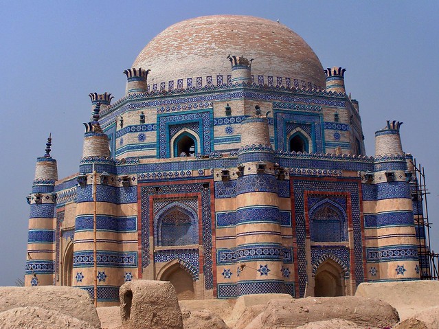
Tomb of Bibi Jawindi, Baha’al-Halim and Ustead and the Tomb and Mosque of Jalaluddin Bukhari. Tentative WHS (30/01/2004). This consists of 5 monuments at the South-West corner of Uch Sharif- representing the town’s most exceptional architecture. The oldest is the fourteenth-century AD tomb and mosque of the Central Asian Sufi Jalaluddin Bukhari. The brick-built tomb measures 18 x 24 meters, its carved wooden pillars support a flat roof and it is decorated with glazed tiles in floral and geometric designs. The ceiling is painted with floral designs in lacquer and its floor is covered with the graves of the saint and his relatives an interior partition provides purdah for those of his womenfolk. Its mosque consists of a hall, measuring 20 meters by 11 meters, with 18 wooden pillars supporting a flat roof. It was built of cut and dressed bricks and further decorated, internally and externally, with enamelled tiles in floral and geometric designs. These structures were joined by a series of domed tombs; the first is said to have been built for Baha’ al-Halim by his pupil, the Suharwardiya Sufi saint Jahaniyan Jahangasht (1307-1383 AD), the second for the latter’s great grand daughter, Bibi Jalwindi, in c.1494 and the third for the latter’s architect. They all have three tiers, an octagonal base supporting a zone of transition surmounted by a dome, and are richly decorated with carved timber, cut and moulded brick, and blue and white faience mosaic tiles. The basement walls taper and are supported by 8 engaged tapering corner towers. The eroded nature of the three allows their profile, construction and decorated interiors to be seen.
Half of all are missing -, in around 1817, the locals stole the bricks. This shows the construction details – 4-meter thick solid brick walls. There were many kids hanging around and all asked what my name was, but not where I was from or what I was doing. Free
Since Sukkur, we have been driving on the Sukkur/Multan Motorway, a magnificent piece of 6-lane divided highway built at huge expense as it is elevated at least 10 m above the surroundings. It has few access points many km apart and is tolled (about 270 RP per 100 km, very cheap by European standards where it costs about 1€/10km) and this may explain why it has virtually no traffic, specifically there are virtually no trucks. The speed limit is 120 and radar speed cameras are well advertised with a sign and the cameras are visible from a kilometre away on a large gantry.
Sadik is incredibly cautious. Most cars go fast between the cameras but he never goes over 120 and when the cameras are announced reduces his speed to 100, just in case. He gets offended when I mention this. His driving on slow roads and through towns is likewise very cautious. He ‘crawls’ over speed bumps and any rough areas of the road. He drives so non-aggressively by not passing when he should and not accelerating that many opportunities are missed and we sit behind big trucks etc a lot.
MULTAN
On the bank of the Chenab River, Multan is Pakistan’s 7th largest city and is the major cultural and economic centre of southern Punjab.
Multan’s history stretches deep into antiquity. The ancient city was the site of the renowned Multan Sun Temple and was besieged by Alexander the Great during the Mallian Campaign. Multan was one of the most important trading centres of medieval Islamic India, and attracted a multitude of Sufi mystics in the 11th and 12th centuries, earning the city the sobriquet City of Saints. The city, along with the nearby city of Uch, is renowned for its large number of Sufi shrines dating from that era.
On the way to Multan, I booked a cheap hotel on Booking.com. On arrival, we were told that there are only five hotels in Multan that allow foreigners and this wasn’t one of them. These rules exist only in Multan because it is a center of uranium production and many foreigners stay here. So we ended up at the Multan Continental. The clerk asked a million questions, part of the heavy security situation in this town.
It turned out well. This is the first hotel we have seen that obtained a hot water kettle for me. It also has very fast wifi. It was great with a good hot shower, fast internet and a very good included breakfast.
Sadik talks to his wife on the phone 2-3 times every day and then spends a lot of time talking to his 4 girls. I am glad I never had to do this.
We were off by 8. On the flyover, we were stopped by a security guard wondering where we were going. I said mosque and there was no problem. Multan is a very unusual city.
Shahi Eidgah Mosque (Eid Ghah Mosque). In north Multan, this is a mosque not to be missed. With two minarets, the outside is not finished and needs paint between all the areas of blue tile. The inside is a riot of Islamic design in the 7 domes, three on each side of the large central dome. The prayer hall is very long and narrow. The lower wall wainscotting needs to be tiled but otherwise beautifully painted.
In the corner of the large square is a spectacular tomb. A four-story high dome, octagonal and embellished with arches, balconies and painted walls.
Tomb of Hazrat Rukn-e-Alam, Multan. Tentative WHS (14/12/1993). The tomb, built in 1320-24 A.D., lies inside Multan Fort. This elegant building is an octagon with a diameter of 15′ 9ù and a side measuring 20’6″. It is the first octagonal tomb in the South Asia subcontinent. The special features in the construction of the Shrine are the tapering walls, horizontal wooden beams embedded at the exterior of brickwork, and a wooden frame built with horizontal and vertical beams. The carved wooden Mehrab is a delicate and intricate piece of work, which is the earliest specimen of its kind in the whole South Asian subcontinent. The structure is built entirely in red brick, the whole exterior elaborately decorated with glazed tile panels in string courses and merlons. The colours used are Indian blue, Persian blue, and white, which contrast with the red of the finely dressed bricks. The enameled tiles have relief patterns, raised from half an inch to two inches from the background. The octagonal second story is elaborately decorated with geometric, floral, and arabesque designs. It is further beautified by calligraphic motifs, brick design in relief pattern of caustic tiles, and ornamental brickwork.
Tomb of Shah Rukn-e-Alam. Tentative WHS (30/01/2004). In Multan in the northwestern edge of the Multan Fort, the mausoleum of the Sufi saint was built between 1320-24. It is considered to be the earliest example of Tughluq architecture and is one of the most impressive shrines in the Indian subcontinent. The shrine attracts over 100,000 pilgrims to the annual urs festival that commemorates his death.
It has three entrances, a western-facing mihrab, and an original main entrance on the southern axis that featured a small vestibule. The main entrance has since been shifted to the east, in an attempt to align the shrine’s axises with Mecca, in accordance with orthodox interpretations of Islam.
Multan had strong links to Persia and Afghanistan – links which are reflected in the heavy influence of Central Asian and Persian architectural styles found at the tomb, such as the use of brick, glazed tiles, and wooden roofs. The shrine represents the culmination of Multani funerary architecture.
The mausoleum is three-tiered, octagonal, 15 metres in diameter, and features walls 4 feet thick. The octagonal first tier is buttressed by small minaret-shaped towers in each of its 8 corners that provide support to the structure.
The mausoleum is built entirely of red brick, bounded with beams of shisham wood, which have turned black over the centuries. The exterior is elaborately ornamented with carved wooden panels, carved brick, string courses, and battlements. Buttresses, turrets, and crenellations at the top of the shrine reflect the influence of Tughluq military architecture on even non-military buildings
The exterior is further embellished with regional-style tile-work in floral, arabesque, and geometric motifs with dark blue, azure, and white tiles – all of which contrast the deep red finely polished bricks. The white dome is decorated with blue tile-work along its lower perimeter.
The shrine’s vast interior features no internal buttresses, nor any interior structural elements to support the interior space, which results in a vast interior space. The carved wooden mihrab is considered to be one of the earliest examples of its genre. The sarcophagus of Rukn-e-Alam is surrounded by the graves of 72 of his relatives, which allude to the 72 martyred companions of the Prophet Muhammad’s grandson, Imam Hussein, at the Battle of Karbala in 680 CE.
The tomb was covered in an elaborate embroidered cloth. Garlands of flowers draped from the side walls and strung across the width of the interior. The mihrab was elaborately carved wood and blue tile. The floor was bright blue tiles. Free
Multan Museum (Musifar Khana Sarafa Bazaar). Historical place museum. There is no specific museum that I could find, simply a large bazaar with multiple streets and side lanes.
The young policeman who stopped us on the flyover continued to escort us to all these places and accompanied me into the tombs and bazaar. He spoke fair English and seemed simply interested. With his AK-47 strapped on his back, he then escorted us for about 20 km out of Multan toward Balochistan, clearing traffic out of our way. I felt like a VIP.
We now had a 600+ km drive (Google Maps said over 10 hours) with no sightseeing stops along the way. It started off well on a good 4-lane divided highway with tolls, but many trucks, buses, and local traffic. We passed several brick kilns belching white smoke near Multan. There was a pall of hazy pollution forming the horizon. Bullocks with big humps pulling carts and of course many motorcycles were on the road.
The 4-lane ended and the two-lane went through towns and with the trucks, speed was slow. Then we hit mountains with many curves and big trucks. One spectacular area went up and over a pass previously with many sharp switchbacks, but now with largely constructed ramps making larger curves for each switchback. It took 4 hours to drive less than 200 km and finally arrive in Balochistan. It will be a long day.
==============================================================
BALOCHISTAN (Quetta, Gwadar, Pasni, Chaman, Khost) Dec 19,20, 2021
As the Canadian government travel advisories are level 4 for B (Don’t go), my BCAA travel insurance will be invalid for the next two days.
We stopped for chai and Sadik had lunch. We soon had a crowd of 11 people watching us.
After this, the road was flat to Quetta through a desert terrain of rocky ground. Low rugged mountains are on either side. There is no irrigation and no fields, only grazing.
But Sadik’s driving is so cautious and slow, it takes a long time. He never goes or even approaches the speed limit. And then he slows down for everything: motorcycles, curves, oncoming traffic and any rough pavement. He crawls over speed bumps. On curving roads with no oncoming traffic, he refuses to cut corners. I criticized this and then he started cutting corners when he couldn’t see if there was oncoming traffic! He gets irritated at the comments. Because he speaks so little English, it is hard anyway. Worst of all, he slows down before he is about to pass and barely accelerates through the pass. Oncoming traffic a long way off is waited for. It is trying my patience, but I say little to keep things happy.
Some other observations of Sadik are that he never brushes his teeth or showers, although he washes his face frequently. He doesn’t smell so I don’t care. He basically is a very pleasant, easy-to-get-along-with guy. He has great driving stamina and appears to never get sleepy.
QUETTA (pop 1.001 million 2017)
The provincial capital and largest city of Balochistan (10th largest in Pakistan). In 1935, Quetta had developed into a bustling city with a number of multi-storey buildings and was called “Little London”. The epicentre of the earthquake was close to the city and destroyed most of the city’s infrastructure, killing an estimated 40,000 people. Quetta is at an average elevation of 1,680 metres (5,510 feet) above sea level. It is known as the “Fruit Garden of Pakistan.
Located in northern Balochistan near the Pakistan-Afghanistan border and the road across to Kandahar, Quetta is a trade and communication centre between the two countries. The Bolan Pass route was once one of the major gateways from Central Asia to South Asia. Quetta played an important role militarily for the Pakistani Armed Forces in the intermittent Afghanistan conflict.
The immediate area has long been one of pastures and mountains, with varied plants and animals relative to the dry plains to the west. The city has a Pashtun plurality followed by Balochs, Hazaras, Brahui, Punjabis and Muhajir people.
We finally reached Quetta at 8 pm, a full 11 hours of driving. We ate at a great restaurant and made a hotel booking. When we got there, they had no rooms and I phoned 4 hotels until we found a bed. But it was cheap.
We actually slept in till 7:30, we were off to see a few places before starting the long drive to Peshewar
Bolan Mosque. This was an unusual mosque to be included in NM. Located 14 km east of the city center on the outskirts of Quetta, it is quite small and appears fairly new. Fronted by a large marble-floored square and brightly painted on the outside with 2 small minarets, the interior was unfinished grey cement with 4 columns. Four small groups were sitting on the floor studying the Koran. I asked if this was a madrassa and just got blank stares. The carpet was simple placemats.
Museum of Geology. The doors were open and the long hallway had storyboards about gems, rocks, meteorites, general geology, and more but the galleries themselves were not open. There was no one around to ask questions of. Free
Quetta Archeological Museum. As it was the off-season, the museum was in the process of moving to a new location at the University of Balochistan and there was not much to see. The usual rather boring (and redundant) Stone Age to modern times artifacts. Free
The following Tentative WHS is listed in the Sindh region, but two of the locations are in Balochistan near Quetta. On our way out of town, I made a detour to see these. They are fascinating irrigation systems originally developed in Iran (where I saw many), but they were also developed in many other places, usually desert locations. They employ underground channels used to prevent evaporation.
Karez System Cultural Landscape. Tentative WHS (12/04/2016). The Karez system of the Balochistan desert is an ancient and still functional community-based water management system in an arid landscape. Karez originated in the 1st millennium BC in Persia and travelled east and westward along the Silk Route, throughout the Muslim world arriving in China during the Han dynasty (206 BC – 24 AD) and in Balochistan somewhat earlier. Used in India, western China, Middle East and North Africa.
Karez, its communities and their lands and pastures combine to form an organically evolved cultural landscape in a harsh environment.
Karez are constructed as a series of well-like vertical shafts, connected by sloping tunnels carrying large quantities of subterranean water by gravity and without need for pumping. The vertical shafts are for maintenance and water is used only when it emerges from the tunnels. Karez allows water to be transported over long distances in hot dry climates without the loss of much of the water to evaporation. The system is resistant to natural disasters such as earthquakes and floods, and to deliberate destruction in war. It is almost insensitive to the levels of precipitation, delivering a flow with only gradual variations from wet to dry years. A karez is environmentally sustainable as it has no additional energy requirement and, thus, has low life cycle operation and maintenance costs.
Karez are owned and maintained by the community who buy shares in it or “shabanas”, 24-hour cycles. A karez, depending upon its size, may have anywhere from 18 to 32 shabanas distributed between its shareholders, with individual claims ranging from the right to a few minutes to a week of water. A shareholder, or shareeq, is entitled to the standing of a country gentleman in the community and may sit in a jirga and weigh in on collective decisions. In this way, the system of water access, distribution and use is closely linked to social structures and community identity. Although a karez system is expensive to construct, its long-term value to the community, and thereby to the group that invested in building and maintaining it, is substantial.
Today, though the system is under threat, there are approximately 1053 functioning karezes in Balochistan having more than 22,000 lps discharge, irrigating 27,000 ha in 2012. Another 270 karez are not functioning but could be restored to use. They are located in the northwest corner of Balochistan bordering with Afghanistan and Iran. A group of four representative karez is being proposed for inclusion on the Tentative List:
1. Spin Tangi Kareze, District Quetta
2. Chashma Achozai Kareze, District Quetta
3. Ulasi Kareze, District Pishin
4. Kandeel Kareze, Muslim Bagh, District Killa Saifullah
After the Kareze, we finally got onto Highway N-50, the major 2-lane road with good shoulders on the western side of Pakistan that parallels the Afghanistan border. There is virtually nothing on this road under Peshawar, over 800 km away. The terrain continues to be a rocky desert. in a wide valley between low dry mountains. There are orchards of trees that have dropped their leaves. Homes consist of clusters or walled compounds of small round or rectangular adobe huts. Large solar panel displays sit beside many.
in the towns, there is a good chance to see the people: older men with turbans and great beards to younger men with trimmed facial hair. There are few women on the streets.
This is the Zhob Valley and is over 10 km wide and pancake flat for most of the way. The road, although just two lanes, is excellent with no potholes and good shoulders. There is little traffic but for a few large trucks, we should be having a great time. If I were driving, we would be there before dark, but it will more than likely be by 10 pm or so with Sadik driving, although things have improved significantly since we talked.
580 km from Peshawar, we encountered the Zhob River, basically a trickle as we crossed a bride bit of mountain. Then the valley opened up again.
Many homes have small ponds (fed by artesian wells?) with pumps and solar panel arrays. There are many fields now in fallow. Orchards and the occasional vineyard appear.
Zhob. We passed through this major town about 500 km from Peshawar. The one-street town was a bottleneck of traffic as one parked car blocked the large trucks. Ths stalls were packed with oranges, apples, bananas, pomegranate, potatoes, tomatoes, red carrots, beans, eggplant, and onions. I usually attract many stares as we drive through but didn’t get one sideways glance once.
After Zhob, we entered the mountains, were stopped at the first major military checkpoint of the trip and entered a dramatic narrow gorge with very high cliffs and running water. The road often passed under great overhangs.
The road eventually opened up onto a great plain with no visible mountains. The road was dead straight for miles. When I asked Sadik why he was only going 80, it was because the road was not completely smooth. OMG, this will take forever. I see us sleeping in the car tonight.
With 300 km left to go at 6 pm, we finally stopped to eat, get gas and buy cigarettes and coffee. Sadik did his usual and ordered a large pot of chicken. I had one piece (it was overcooked) and he ate less. He always leaves most of his food on his plate. It pisses me off. I should not let these small things bother me. But we now have over 5 hours of driving in the dark, probably more as he is only going 60!!! OMG, It is so dangerous to be driving at night – most motorcycles and many trucks don’t have tail lights, many cars don’t turn their headlights on, and when trucks stop, they cover the road with rocks. It was astonishing how many trucks were on the road in the dark. Many were not going over 20km/hr.
On the other hand, Sakik has incredible driving endurance (over 15 hours today) and never complains about anything including my bitching. He is good-natured and easy to get along with. It is fine that he doesn’t speak English – that way I don’t have to carry a conversation. If there is anything to say, we both use Google Translate.
We finally made it to Peshawar at 12:45 am and found a hotel.
I didn’t visit the following places as they were very off course a long way off the main highway. Mehrgarh was a 2.5-hour drive east and totally out of the way. Hingol is in the far south of the Indian Ocean and would have to be visited from Karachi. I include them for information’s sake.
Ziarat Juniper Forest. Tentative WHS (12/04/2016). These forests are spread around a mountainous area of Ziarat and Mount Zarghoon – 1,181 to 3,488m elevation. The climate is temperate and semi-arid. The Pashtun juniper occurs between 2000 and 3,000 meters elevation along ridge tops and on moderate to steep slopes (18º to 30º). They grow mostly in dense, open, and pure stands without stratification. The age of the oldest trees is 5000 to 7000 years, for which they are called living fossils. Slow-growing and long-lived, they’ve been harvested for firewood, timber, and various medicinal and aromatic plants and have declined with little regeneration. Increasing human population, overgrazing by livestock, illegal timber cutting, overharvesting of firewood and juniper seeds, periodic droughts, attack on weakened trees by parasitic fungi and the mistletoe and climate change.
In 2013 the forest was declared a biosphere reserve.
Archaeological Site of Mehrgarh. Tentative WHS (30/01/2004). is a Neolithic archaeological site (dated c. 7000 BCE – c. 2500/2000 BCE) situated on the Kacchi Plain of Balochistan in Pakistan. It is located near the Bolan Pass, to the west of the Indus River and between the modern-day Pakistani cities of Quetta, Kalat and Sibi. The site was discovered in 1974 and archaeological material has been found in six mounds, and about 32,000 artifacts have been collected from the site. The earliest settlement at Mehrgarh—located in the northeast corner of the 495-acre (2.00 km2) site—was a small farming village dated between 7000 BCE and 5500 BCE.
Mehrgarh is one of the earliest known sites that shows evidence of farming and herding in South Asia with domesticated wheat varieties, early phases of farming, pottery, other archaeological artifacts, some domesticated plants and herd animals.
The oldest (and first early Neolithic) evidence for the drilling of human teeth in vivo (i.e. in a living person) was found in Mehrgarh.
5500 BCE–3500 BCE). Evidence of manufacturing activity with glazed faience beads and terracotta figurines, stone and copper drills, updraft kilns, large pit kilns, and copper melting crucibles. There is evidence of long-distance trade.
Early Mehrgarh residents lived in mud brick houses, stored their grain in granaries, fashioned tools with local copper ore, and lined their large basket containers with bitumen. They cultivated six-row barley, einkorn and emmer wheat, jujubes and dates, and herded sheep, goats and cattle.
Residents of the later period (5500 BCE to 2600 BCE) put much effort into crafts, including flint knapping, tanning, bead production, and metalworking. Mehrgarh is probably the earliest known center of agriculture in South Asia.
The oldest known example of the lost-wax technique comes from a 6,000-year-old wheel-shaped copper amulet found at Mehrgarh. The amulet was made from unalloyed copper, an unusual innovation that was later abandoned.
Hingol Cultural Landscape. Tentative WHS (12/04/2016). Hinglaj Mata Mandar is an ancient but living cultural landscape located in Hingol National Park on the Makran coast of the Arabian Sea, approximately 190 km west of Karachi. The famous ancient Hindu religious place is in a mountain cave on the bank of the Hingol River. It predates the Arab invasion and the advent of Sufism. The goddess Shaktior Sati, the female principal of Hinduism is worshipped. Hindus believe that the head of goddess Sati fell in the area of Hinglaj Mata when her body was dismembered by Vishnu and it has remained a revered pilgrimage site for Hindus. Local Muslims also revere the place, calling it Nani Mandar, and serve as custodians of the cave temple.
It is the largest National Park of Pakistan with an area of 6,190 km2. The park is named for the Hingol River which flows through it, forming an estuary as it enters the Arabian Sea. Hingol National Park contains a diverse range of landscapes from the depths of the Arabian Sea to the intertidal, beaches and the estuary of the Hingol River to the Dhrun Mountains with its highest point at 1,580 m. Large tracts of the park are covered with drift sand and can be classified as coastal semi-desert with arid montane and rugged mud rock formations along the coast. These mud rock formations are a mass of east-west folds, created by the northward thrust of the Indian Ocean plate under the continental crust, characterized by deep and barren rocky gullies, cliffs and caves.
The shrine is located in one of these natural caves on a stream leading to the Hingol River. There is no temple structure, just a low mud altar and a small stone worshipped as the goddess. Throughout the year, thousands of Hindus visit with 5,000 in April.
Worshippers also visit the mud volcanoes which are a special feature of the park. In the subduction zones and the Makran coastal area where three major tectonic plates – namely Eurasian, Arabian and Indian plates meet. There are about ten locations in the Hingol and Hinglaj area having clusters of mud volcanoes, the most important being Chandragup and Khandewari volcanoes, sacred to the followers of the Vedas who pause there on their pilgrimage to Sri Mata Hinglaj.
Hingol NP
HARAPPA
Archaeological Site of Harappa. Tentative WHS (30/01/2004). About 24 km (15 mi) west of Sahiwal. it is a small crossroads town of 15,000 people today. The site of the ancient city contains the ruins of a Bronze Age fortified city, which was part of the Indus Valley Civilisation centred in Sindh and Punjab, and then the Cemetery H culture. The city had 23,500 residents occupying 150 hectares with clay brick houses at its greatest extent from 2600 BC – 1900 BC).
The ancient city of Harappa was heavily damaged under British rule when bricks from the ruins were used as track ballast in the construction of the Lahore–Multan Railway. In 2005, a controversial amusement park scheme at the site was abandoned when builders unearthed many archaeological artifacts during the early stages of building work
