
PAKISTAN – Sindh other (Hyderbad, Sukkur) Dec 16, 17, 2021
After 7 days in Karachi, I was finally able to get an activated SIM card (Jazz for 7.5€ for 30 days and 15 GB), exchange cash (ATMS don’t work here), and rent a car ZJ Car rental, Karachi, a 2021 Toyota Corolla for 10 days with a driver who is mandatory for 70,000 PR. I need to pay for his food and accommodation and we will see how that turns out.
Day 8
I went to his office to sort out business and pay. We left at noon with a hectic schedule. I get to sit back, relax, read and take it easy.
Chaukhandi Tombs, Karachi. Tentative WHS (14/12/1993). An early Islamic cemetery 29 km east of Karachi. Noted for their elaborate sandstone carvings, similar in style to the elaborate tombs at the Makli Necropolis near Thatta, and are built in the funerary architectural style typical of lower Sindh. Mainly Baloch, they were mainly built during Mughal rule sometime in the 15th and 18th centuries when Islam became dominant.
The more elaborate graves are constructed with a buff-colored sandstone, preserved in the arid local climate. A typical sarcophagus consists of six vertical slabs covered by a second sarcophagus consisting of six more similar vertical slabs but smaller in size, giving the grave a pyramid shape. The upper box is further covered with four or five horizontal slabs and the topmost construction is set vertically with its northern end often carved into a knob known as a crown or a turban for men. The tombs are embellished with geometrical designs and motifs, including figural representations such as mounted horsemen, hunting scenes, arms for men, and jewelry for women.
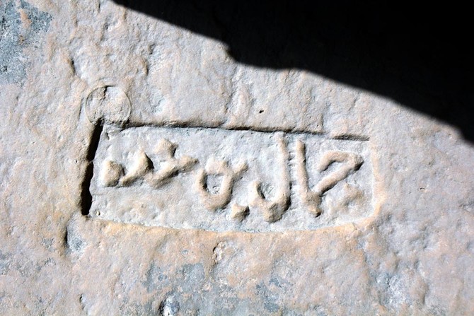
The tombs are all remarkably similar with very elaborate intricate carving. The name of the deceased is in small script on the north end of the second horizontal level. I would not have even noticed this if it had no been pointed out by a local fellow. It is only a name with no dates. If it were not for the arid climate, these inscriptions would have eroded off with rain by now. There are two sets of graves on platforms covered by domes. These were the important people but the tombs themselves were no different.
There were several graves consisting of simple piles of rocks. Free 

Port of Banbhore. Tentative WHS (30/01/2004) is a city dating to the 1st century BCE located on the N-5 National Highway, east of Karachi, between Dhabeji and Gharo. It dates back to the Scytho-Parthian era and was later controlled by Muslims from the 8th to the 13th century, after which it was abandoned. Remains of one of the earliest known mosques in the region dating back to 727 AD are still preserved in the city.
Three distinct periods: Scytho-Parthian (1st century BC to 2nd century AD)
Hindu-Buddhist (2nd century AD to 8th century AD), and early Islamic (8th century AD to 13th century AD). The city was gradually deserted after the 13th century due to change in the course of the Indus.
Bhanbhore was a medieval port city deriving its wealth from imported ceramic and metal goods, an industrial sector, and trade. The city was strategically located at the mouth of the Indus, linking it with rest of the Indo-Scythians and Indo-Parthians and international traders in the Indian Ocean. Archaeological findings show a half-submerged anchorage structure with solid stone foundation, which may have been used for berthing cargo boats. However, the port was abandoned when the Indus River shifted its position and the creek was silted.
Archaeology. The city consisted of an enclosed area surrounded by a stone and mud wall. The citadel was divided into eastern and western sections by a fortified stone wall in the center. The eastern part contains ruins of a mosque with an inscription dating to 727 AD, sixteen years after the conquest of Sindh, indicating the best-preserved example of the earliest mosques in the region. Remains of houses, streets, and other buildings have been found both within and outside the citadel. Contemporary stone buildings from the three periods are also uncovered in the area including a palatial stone building with semi-circular shape, a Shiva temple from the Hindu period, and a mosque. Three gateways to the citadel were also uncovered during excavations.
The museum had mostly pottery, stone, and jewellry.
Haleji Lake is a perennial freshwater lake in Thatta District. It is 6.58 km2 (2.54 sq mi) in size and is surrounded by marshes and brackish seepage lagoons. Haleji Lake was a saline lagoon until the 1930s and was converted into a reservoir to provide additional water to Karachi. During World War II, additional water was required for troops stationed at Karachi. The then-British Government of Sindh Province decided to increase the capacity of the lake by introducing a feeder canal from the Indus River. Salt water was drained out and an embankment was constructed around the lake which was fed with fresh water through a canal. The work was placed on a war footing and was completed within 24 months.
Haleji Lake is a wintering site for waterfowl such as cotton teal, Indian spot-billed duck, purple moorhen and pheasant-tailed jacana. It is also a breeding site for egrets and herons.
Reeds grow into the lake in places. The lake was not as interesting as the drive. We drove along irrigation ditches and farms. There were many thatch shacks housing very impoverished families. Kids and adults came out to the road to beg. Yound girls were carrying bundles of branches.
The road was under construction with half a constructed dirt bed. People were spreading large rock crush by hand and then shoveling sand on this. Rollers had compacted it ready for paving
THATTA
Thatta was the medieval capital of Sindh for three successive dynasties. Several monuments remain.
Ibn Sumar, from Multan, founded the Sumra dynasty, which ruled from Thatta from 1051 for the next 300 years. The Shia population was granted special protection.
In 1351, the Samma Dynasty, of Rajput, seized the city and made it their capital. The Makli Necropolis rose as a funerary site. Thatta’s Makli Necropolis, a WHS, is site of one of the world’s largest cemeteries and has numerous monumental tombs built between the 14th and 18th centuries designed in a syncretic funerary style characteristic of lower Sindh.
In 1520, Shah Beg of the Arghun-Tarkhun dynasty, from Afghanistan took control but fell into disarray in the mid 1500s and asked for aid from the Portuguese in 1555. 700 Portuguese soldiers arrived in 28 ships when Isa Tarkhun had already emerged victorious. After the Tarkhuns refused to pay the Portuguese soldiers, the Portuguese plundered the town, robbing its enormous gold treasury, and killing many inhabitants. Despite the 1555 sack of Thatta, it remained one of the richest cities of the Orient.
In 1592, Thatta was governed by the Mughal Empire based in Delhi, which lead to a decline in the city’s prosperity. Shah Jahan, while still a prince, sought refuge in the city from his father Emperor Jahangir.
The Indus River silted in the second half of the 1600s, and the seaport was abandoned. Thatta remained Sindh’s largest economic centre, and its largest centre for textile production. In the mid 1700s, Thatta fell into neglect, as the Indus River also began to silt. In the early 19th century Thatta had declined to a population of about 20,000, from a high of 200,000 a century before. In 1920, the estimated population of the city was 10,800.
Thatta is not a very attractive city. Wealth of any kind is not visible.
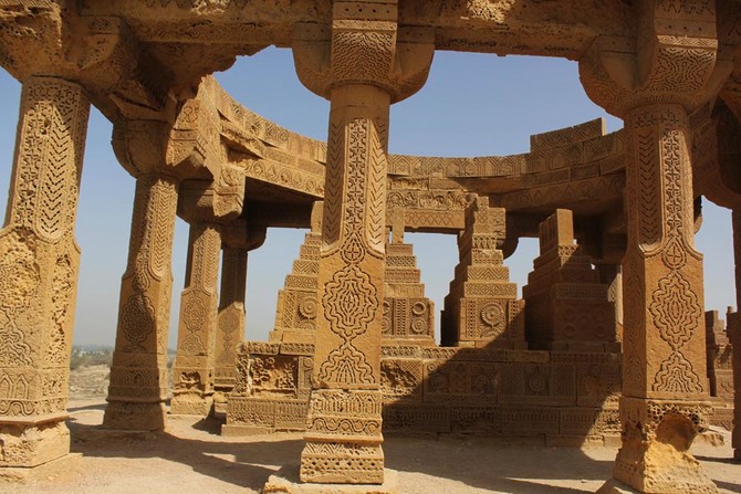
Historical Monuments at Makli. WHS 1981. The Makli Necropolis is one of the largest funerary sites in the world, spread over 10 kilometres near the city of Thatta. There are 500,000 to 1 million tombs built over the course of a 400-year period. Makli Necropolis features several large funerary monuments belonging to royalty, various Sufi saints, and esteemed scholars. Outstanding testament to Sindhi civilization between the 14th and 18th centuries.
Ot the graves, the vast majority are simply long piles of rocks, Next most common are unmarked cement graves built on small platforms. There are perhaps 6 large mausoleums worth seeing. The best is that of Isa KhanTackhan II who died in 1612 at age 90 – a 2-story large dome with carved sandstone walls, columns, ceilings and pilars. Jan Baba tomb is near, with carved sandstone walls and 3 domes. Don’t walk further than the tomb of Sultan Mohammud and Sultan Ibraham. The brightly coloured structure is a modern mosque converted into a bazaar with knick-knacks (they still wouldn’t let me enter with shorts). Some have intricate tile work and turquoise stone between layers of brick. All are locked that need to be opened if there is a fellow there. Free


Shah Jahan Mosque. Tentative WHS (14/12/1993). In 1592, Thatta was governed by the Mughal Empire based in Delhi, which lead to a decline in the city’s prosperity. Shah Jahan, while still a prince, sought refuge in the city from his father Emperor Jahangir.
In 1626, Shah Jahan’s 13th son, Lutfallah, was born in Thatta. The city was almost destroyed by a devastating storm in 1637. As a token of gratitude for the hospitality, Shah Jahan bestowed the Shah Jahan Mosque to the city in 1647 as part of the city’s rebuilding efforts.
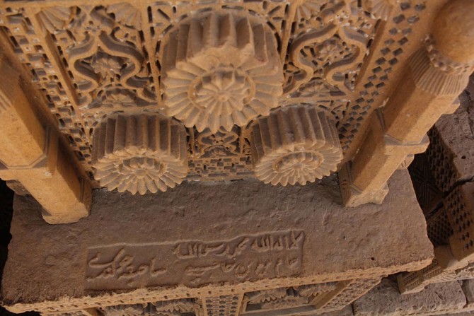
It is a heavy brick structure of simple construction built upon a stone plinth, with heavy square pillars and massive walls, is centred around a courtyard 169′ X 97′. The prayer chamber is of a similar size. Both are covered by large domes. On the north and south two aisled galleries open by means of arcades onto the courtyard. Ninety three domes cover the entire structure, and are probably the cause of a remarkable echo, which enables the prayers in front of the Mihrab to be heard in any part of the building. 60 of the the domes are exquisite brick work and form two arcades surrounding the courtyard.
The mosque is richly embellished with decorative tiles – the most elaborate display of tile-work in the Indo-Pakistan sub-continent. The two main chambers, in particular, are entirely covered with them. Their domes have been exquisitely laid with a mosaic of radiating blue and white tiles. Stylish floral patterns, akin to the seventeenth century Kashi work of Iran, decorate the spandrels of the main arches and elsewhere geometrical designs on square tiles are disposed in a series of panels.
Shah Jahan Mosque features extensive tile work that displays Timurid influences introduced from Central Asia.
Keenjhar Lake commonly called Malik Lake is located in Thatta District of Sindh. It is situated about 36 kilometres (22 mi) from the city of Thatta. It is the largest freshwater lake in Pakistan and an important source of drinking water for Thatta District and Karachi city. Through the construction of a bund on the eastern side, it is said that the lake was formed by the union of two lakes: Sonehri and Keenjhar. large patches of reeds grow in the lake.
Keenjhar Lake has been declared a Ramsar site and a wildlife sanctuary. It provides a favorable habitat of winter migratory birds like ducks, geese, flamingos, cormorants, waders, herons, egrets, ibises, terns, coots, and gulls. It has been observed as a breeding area of the black-crowned night heron, the cotton pygmy goose, purple swamphen, and pheasant-tailed jacana.
Keenjhar Lake is a popular tourist resort. Many people from Karachi, Hyderbad, and Thatta visit to enjoy picnics, swimming, fishing, and boating. The famous folklore of Noori Jam Tamachi who was a fisherwoman is connected to the lake. There is a shrine in the middle of the lake marking Noori’s grave, which is visited by devotees.
Until about 40 km before Hyderbad the road traverses pancake-flat land formed by the estuary of the Indus and it multiple courses. It is very dry country that would have difficulty supporting crops were it not for irrigation possible by an extensive canal network,
Pass many trucks laden with the most amazing loads that stick out a few meters from the top of the truck like a giant turban – all supported by logs, cloth and ropes. It must be a special skill to even construct them.
Speeds are kept slow (usually below 80 km/h) on the 2-lane highway because of all the slow traffic – motorcycles, trucks, pedestrians on the road. And this is the main national highway between Karachi and Lahore!
There is a lot of abject poverty – you pass many cane/thatch huts.
HYDERABAD (pop 1,732,693)
The second-largest city in Sindh and 8th largest in Pakistan, it was founded in 1768. It is about 150 kilometres (93 mi) inland of Karachi. The industrial sector contributes 25% to the GDP of Pakistan with 75% of Sindh’s industry in the Karachi-Hyderabad region. Industries includes: textiles, sugar, cement, manufacturing of mirror, soap, ice, paper, pottery, plastics, tanneries, hosiery mills and film. There are hide tanneries and sawmills. Handicraft industries, including silver and gold work, lacquer ware, ornamented silks, and embroidered leather saddles, are also well established. Hyderabad produces almost all of the ornamental glass bangles in Pakistan, as well as layered glass inlay for jewelry.
Hyderabad is surrounded by fertile alluvial plains, and is a major commercial center for the agricultural produce of the surrounding area, including millet, rice, wheat, cotton, and fruit.
Entering Hyderbad in the early evening was mayhem. We crossed a huge metal-girder bridge with one lane on each side of a railway track. Motorcycles squeezed by on the left and even some came from the opposite direction. After the bridge, the one lane road became clogged with 3 lines of traffic – motorcycles, rickshaws and cars. We finally ate at a restaurant and booked a cheap hotel in the downtown area. Sadik stayed at his brother’s place and picked me up at 7 to start a long day. Hopefully the roads improve.
Garbage is everywhere. This is a much poorer and less sophisticated city than Karachi, that I thought was not very sophisticated. The contrast between between the children in their smart uniforms being escorted to school by their mothers and the street urchins rifleing through garbage tips is devastating. Women were wrapped in blankets squatting beside the road or huddled on steps We drove through Hyderbad in the early morning when there was almost no traffic, a startling contrast to the mayhem the night before.
Sindh Museum. In a lovely brick building topped with blue tiles, this has all the archaeological artifacts and ethnographic material found in most regional museums. 300 PR
Paco Qillo, This fort was constructed around 1768 when the city of Hyderabad was founded and in 2017 the fort still exits in its natural shape. Used by Mir Fateh Ali Khan as residence and court in it, a Haram and other buildings were added to accommodate the ruling family and his relations. Mosques were built. it was gradually swarmed with shabby and odd buildings of the working class. Blasts destroyed most of the buildings and houses and in 1857, the British razed most of the remaining buildings to ground to making room to accommodate troops and military stores.
Built on on a 10 m high natural stone rock, this huge fort has high walls of crumbling stone and brick. The entrance is not obvious although it is filled with more modern houses and buildings. Free
We were finally out of the mess of Hyderbad by 7:45 and hit a major 4-lane divided freeway with virtually on traffic. Things were looking up for a faster day of driving. The speed limit is 100 with reductions to 50 in the towns.
We drove through an entirely different landscape obviously with extensive irrigation – plantations of banana, mango, rice, sweet pea, vegetables and sugar cane, all heavily treed, then flat fields. This looks like the agricultural breadbasket of Pakistan.
The road was tolled, well worth the price – about 80 PR per 50 km.
Mirpur Khas. A NM city,
We headed towards Umarkort Fort but it was a long detour and not worth the effort so decided to skip it and go to the wetlands.
The 4-lane divided highway turned into much slower 2-lane with bicycles, motorcycles, rickshaws and much slower driving. Deciding to go SE of Hyderbad turned out to be a bad idea with a lot of driving to not see much. It would have been much better to continue to Rani Kot Fort.
Chotiari Wetlands Complex. 30-35 km northeast of Sanghar, 18,000 ha, 60 m above sea level. The complex includes the Thar Desert sand hills on east, north, north-east and south-east, and Nara Canal on the west and south. Many fresh and brackish water bodies (1-200 ha.). Hot arid climate to 40°C during May and June.
Several threatened species: caracal and white- backed vulture, Indian wolf, hog deer, marbled teal, Pallas’s fish eagle, imperial eagle, saker falcon, houbara bustard, Sindh babbler and Indian marsh crocodile. The Nara Canal Wetlands Area includes Soonhari, Sadhori and Sanghriaro Lakes, an important bird area.
Chotiar Dam is at the end of Nara canal, near Achro city
Nawabshah (pop 280,000 city, 1.435 million in area). A NM city.
Day 9
RANI KOT FORT, Dadu Tentative WHS (14/12/1993) is a historical Talpur fort near Sann, Jamshoro District. Ranikot Fort is also known as The Great Wall of Sindh and is believed to be the world’s largest fort, with a circumference of approximately 32 kilometres (20 mi). The fort’s ramparts have been compared to the Great Wall of China.
Ranikot Fort is 90 kilometres (56 mi) to the north of Hyderabad on the Indus Highway (N55). A diversion road, starting a little distance away from Sann, the nearest town, leads to the fort along a rugged 21 kilometres (13 mi) road and reaches the eastern gate of the fort, known as Sann Gate. Sann is a railhead on the Kotri-Larkana line of the Pakistan Railway. The fort is inside the Kirthar National Park, the second-largest national park in Pakistan.
History. The original purpose and architects of Ranikot Fort are unknown. The fort originated under the Talpurs and was constructed during the administration of Nawab Wali Muhammed Leghari, the Prime Minister of Sindh during the Talpur dynasty with the 17th century as the time of its first construction. Some of the present structures were reconstructed by the Talpur dynasty in 1812 at a cost of 1.2 million rupees. The battlements of Ranikot formed the last capital of the Amirs of Sind, when they were brought under the colonial rule of the British Empire.
Features. The fort is huge, connecting several bleak mountains of the Kirthar hills along contours, and measures 31 kilometres (19 mi) in length. The fort’s wall is interspersed with several bastions, and three are of semi-circular shape. The northern part of the fort’s perimeter is a natural high hilly formation while on the other three sides it is covered by fort walls. Within this main fort, there is a smaller fort known as the “Miri Fort” which is about 3 km from the Sann gate and is reported to have served as the palace of the Mir royal family. The entire fort structure has been built with stone and lime mortar. The fort is built in a zig-zag form, with four entry gates in the shape of a rhomboid. The four gates are namely: Sann Gate, Amri Gate, Shah-Pere Gate, and Mohan Gate. Two of the gates, facing each other, are crossed diagonally by the Sann river; the first gate is on the western side and is skirted by the river water and is difficult to approach. The southern entry gate has a double doors gate. Within the gates, there are two niches that have floral ornamentation and carved stones.
The Sann gate is well preserved and can be climbed to reach the top of the fort from both sides to get a scenic view of the terrain around the fort. This gate is also the entrance to the Meeri.
Restorations were poorly done with cement and new stonework without conforming to the “Venice Charter for the Conservation and Restoration of Monuments and Sites” and recommended stoppage of further work on the fort in 2006.
Manchar Lake is the largest natural freshwater lake in Pakistan and is one of Asia’s largest. It is located west of the Indus River, in Jamshoro District. Lake Manchar collects water from numerous small streams in the Kirthar Mountains, and then empties into the Indus River. The lake’s surface area fluctuates with the seasons – from as little as 36 km² to as much as 500 km² during monsoon rains.
The lake was formed when a branch of the Indus River flowed from Kashmore. In 1958, the lake completely evaporated due to drought. Between 10 August and 23 August 2009, 700 cu ft/s (20 m3/s) of water was introduced in the lake via the Indus River. In the 2010 Pakistan floods, the lake overflowed due to a high inflow of water.
The average depth is only 2.5 to 3.75 metres. It is 6 metres lower than the bed of the Indus and sometimes catches floodwater from the river, while in winter when the river is low, water flows from the lake into the Indus. Rainfall in the area averages only 4.46 inches annually. The southern end of the lake is at the base of the Laki Hills, a branch of the Kirthar Mountains.
The lake supports thousands of fisherfolk, who depend on the freshwater fish in the lake. The lake since the construction of the Main Nara Valley Drain in 1921 has undergone environmental degradation with the inflow of sewage. Consequently, the water quality of the Lake has been degraded.
The diversion of water from the Indus and diminished storm runoff from the Kirthar mountains have contributed to the reduction in freshwater supplies, resulting in the water becoming saline, and killing off fish. At the same time, saline drainage water from agricultural fields of Balochistan and surrounding areas flows into Lake Manchar. The lake was a stop-off on the Indus flyway for Siberian migratory birds, but recently the numbers have fallen from 25,000 birds counted in 1988 to just 2,800 birds counted in 2002 because the lake no longer provides the birds’ main food, the lake fish. In the place of the birds, the lake now hosts a saline water reed.
The lake also provided large volumes of water for irrigation, but this has also been reduced and has resulted in a great reduction in the area irrigated by the lake. Right Bank Outfall Drain is being built to save the lake from contamination. Construction of the Nai Gaj Dam upstream from the lake will result in freshwater being discharged into the lake throughout the year, instead of seasonally, which should improve the lake’s waters.
Lake Manchar is populated by the Mohana tribe, who are sometimes referred to as the “Boat People.”
Archaeological Ruins at Moenjodaro WHS. Meaning ‘Mound of the Dead Men”, it is an archaeological site built around 2500 BCE. It was one of the largest settlements of the ancient Indus Valley Civilisation, and one of the world’s earliest major cities, contemporaneous with the civilizations of ancient Egypt, Mesopotamia, Minoan Crete, and Norte Chico. Mohenjo-daro was abandoned in the 19th century BCE as the Indus Valley Civilization declined, and the site was not rediscovered until the 1920s.
It is situated on a ridge in the middle of the floodplain of the Indus River Valley, around 28 kilometres (17 mi) from the town of Larkana. The subsequent flooding has since buried most of the ridge in silt deposits.
The Harappan Civilization spanned much of what is now Pakistan and North India, extending westwards to the Iranian border. Mohenjo-daro was the most advanced city of its time, with remarkably sophisticated civil engineering and urban planning. Mohenjo-daro has a planned layout with rectilinear buildings arranged on a grid plan. Most were built of fired and mortared brick; some incorporated sun-dried mud-brick and wooden superstructures. A “weak” estimate of a peak population is around 40,000.
The Citadel – a mud-brick mound around 12 metres (39 ft) high – is known to have supported public baths, a large residential structure designed to house about 5,000 citizens, and two large assembly halls. The city had a central marketplace, with a large central well. Individual households or groups of households obtained their water from smaller wells. Wastewater was channeled to covered drains that lined the major streets. Some houses, presumably those of more prestigious inhabitants, include rooms that appear to have been set aside for bathing, and one building had an underground furnace (known as a hypocaust), possibly for heated bathing. Most houses had inner courtyards, with doors that opened onto side-lanes. Some buildings had two stories.
Mohenjo-daro had no series of city walls, was fortified with guard towers, it is postulated that Mohenjo-daro was an administrative center.
Over 700 wells (one for every three houses) are present alongside drainage and bathing systems, unheard of when compared to other civilizations at the time, such as Egypt or Mesopotamia. The circular brick well design is credited to the Indus civilization. Sewage and wastewater for buildings at the site were disposed of via a centralized drainage system that ran alongside the site’s streets emptying into the Indus River.
The city could have been flooded and silted over, perhaps six times.
Artifacts. Bronze and copper figurines and bowls indicate they knew the lost wax technique. Shell-working, Copper tablets with an untranslated Indus script.
Mother Goddess Idol. Discovered in 1931, 18.7 cm tall and is currently on display at the National Museum of Pakistan, in Karachi. Bronze statuette “Dancing Girl”, 10.5 centimetres (4.1 in) high and about 4,500 years old,
Seven-stranded necklace. 4,500 years old, S-shaped clasp with seven strands, each over 4 ft long, of bronze-metal bead-like nuggets which connect each arm of the “S” in filigree. Each strand has between 220 and 230 of the many-faceted nuggets, and there are about 1,600 nuggets in total. The necklace weighs about 250 grams.
Other than the history, this is not a worthwhile WHS. There are only melting and low reconstructed walls. Some of the labels are Dustbin, Oval Well, Double Walled Well, Great Bath. The only structure of note is a Buddhist stupa dating to 2 AD, about 16 centuries after the Indus civilization. 600 PR
It is my 700th WHS.
Larkana (pop 491,000). A NM city, it is called the city of Holy Alams (Shia Muslims’ religious flag) due to the greatest number of Holy Alams as compared to other cities or regions of the world. It is the 15th largest city of Pakistan by population. It is home to the Indus Valley Civilization site Mohenjo-daro. The historic Indus River flows in the south of the city.
Larkana has a hot desert climate with sweltering summers and warm winters. The highest recorded temperature is 53 °C (127.4 °F), and the lowest recorded temperature is −4 °C (24.8 °F). The annual rainfall is 127.4 mm (5.02 in), and mainly occurs in the monsoon season (July to September). The highest annual rainfall ever is 580.2 mm (22.84 in), recorded in 1994 and the lowest annual rainfall ever is 7.1 mm (0.28 in), recorded in 1938.
We stayed at an expensive hellhole of a hotel, the Hotel Sambara. No wifi, no hot water. I am now up at 3 am down at the lobby using the wifi and trying to have a cup of coffee.
Observations about North Sindh
1. This is rice country with some sugar cane. Water is copious from irrigation systems from the Indus River whose many channels cover a huge area. The country is dead flat making these crops easy. Others include bananas, palms (both oil palms and date palms). Wetlands are common and there are a lot of trees.
2. Rice straw is carried in the most enormous loads – on trucks and trailers pulled by tractors (often with a grill emblazoned with reflectors and decoration). The loads are piled high and wide, often overlapping the sides by up to 2 metres. The trucks often carry the straw in loads secured by cloth held together with ropes and logs that extend well past the the box of the truck. Sugar cane is similar.
3. Donkeys are the most common way to transport small loads on carts. They are small by our standards, appear well cared for with jaunty quick steps and perky ears. Camels sometimes are the beast of burden.
Other animals are cattle, water buffalo, sheep, goats and more feral dogs than in the south.
4. Vehicles. Motorcycles are by far the most common, often with 3-5 passengers if a family. Motorcycles often pull carts. They are fearless and behave as if they own the road. Cars are not common. Small trucks loaded with people are common. Small vans and buses are not common here.
5. Food. Pakistanis have the odd habit of never finishing the food on their plates. They always leave a significant amount. Sidik does this with every meal and the boys at the hotel in Karachi always had a pile of dishes after every meal covered in unfinished food.
For breakfast, we stopped at a restaurant with tables. I had small amounts of three curries with a base each of chickpeas, potato, and rice. All taste about the same and are mildly spiced. Eat with your hands using roti. Chai is routine. Cost for both or us 350PR (1.75€).
Kot Diji (Fort Ahmedabad) Rohri Hills. An ancient forerunner of the Indus Civilization beginning in 3300 BCE, it was built by the Talpur between 1785-1795. The fort sits on a 110-foot high hill. Its 30 foot high walls resulted in a narrow-width fortress with 3 towers each 50 feet high. remains consist of two parts; the citadel area on high ground (about 12 m), and the outer area. Located about 24 km south of Khairpur on the east bank of the Indus opposite Mohenjo-daro (but 120 kms away!)
KHAIRPUR*
This is a huge fort winding narrowly on a high ridge with high walls and large round towers on the points. Inside there is not much to see. 200PR
KHAIRPUR*
Herbarium and Botanical Garden (Shah Abdul Litif University). Large areas of grass, hedges, palm trees, and smaller trees. A brick building with herbs. Not very interesting Free
Faiz Mahal was built by Mir Sohrab Khan in 1798 as the principal building serving as the sovereign’s court for the royal palace complex of Talpur monarchs of the Khairpur dynasty. Originally it included the ruler’s chambers along with 16 waiting rooms for courtiers and guest rooms for royal guests alongside the durbar and dining halls. Additionally there was the Hathi Khana for the royal elephant and the horses stables where today there is a mango orchard.
At present, Faiz Mahal serves as the home of the last Talpur monarch, H. H. Mir Ali Murad Khan Talpur II (born 1933), and his sons Prince Abbas Raza Talpur and Prince Mehdi Raza Talpur. After the original Constituent Assembly of Pakistan was abolished by the Chaudry Ghulam Mohummed/General Iskander Mirza dictatorships, Khairpur state was merged with Pakistani state in 1955 using threat of military invasion in violation of the agreement Mir Ali Murad had with the founder of Pakistan, Muhammad Ali Jinnah. Today the former sovereign is an environmentalist and has to his credit an extraordinary flora and fauna safe haven called the Mehrano reserve, famous for its black buck, and hog deer, which are now rare in Sindh.
This is not open to the public. The palace has.a low wall and the whole estate is surrounded by a high wall. I had a good view from this angle.

Sukkur (pop 552,000). A NM city, is a city along the western bank of the Indus River, directly across from the historic city of Rohri. Sukkur’s hill, along with the hill on the river island of Bukkur, forms what is sometimes considered the “Gate of Sindh”.
The region around Sukkur has been inhabited for millennia. The ruins of Lakhan-jo-daro, located near an industrial park on the outskirts of Sukkur, date between 2600 BCE and 1900 BCE
“Old Sukkur” was initially a small village prior to the establishment of a military garrison in 1839. Modern Sukkur, or New Sukkur, was built during British rule alongside what was once a small village directly across from the historic city of Rohri in 1839.
Completed in 1889, Sukkur’s Lansdowne Bridge connects the Sukkur to Rohri across the Indus, and was one of the first bridges to cross the river. The bridge made the journey between Karachi and Multan easier. The bridge was built with two large pylons rather than a series of pillars extending across the river – a cutting-edge design for such an expansive span. The bridge was also made of metal.
Sukkur Barrage (formerly called Lloyd Barrage), built under the British Raj on the Indus River, controls one of the largest irrigation systems in the world and built between 1923 and 1932. The 5,001 feet (1,524 m) long barrage is made of yellow stone and steel and can water nearly 10 million acres (40,000 km2) of farmland through its seven large canals>
Sukkur has a hot desert climate with very hot and hazy summers with dry and cool winters. Wind speed is low throughout the year. The average annual rainfall of Sukkur is 87.6 mm (3.45 in) and mainly occurs in the monsoon season.