
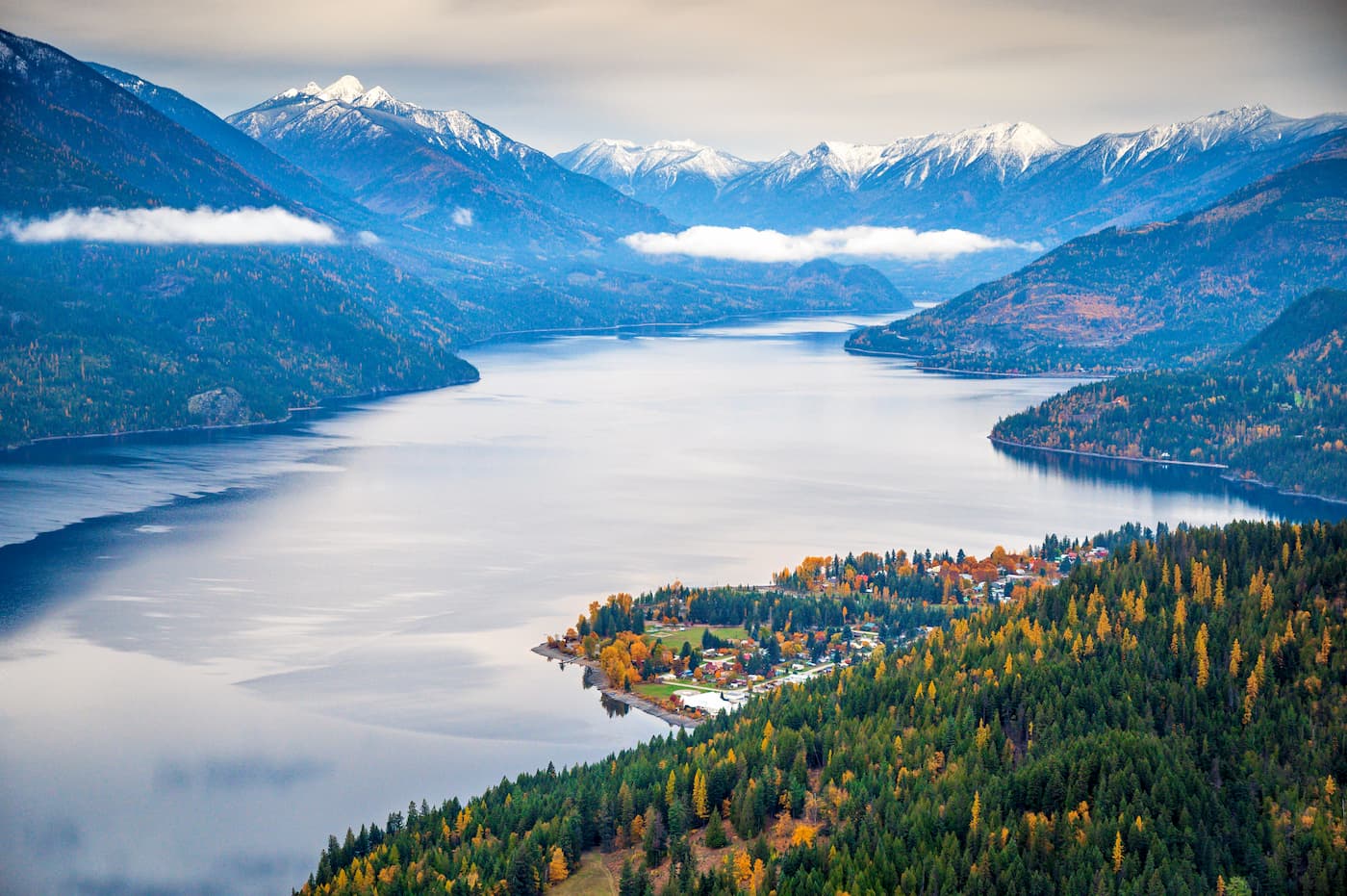
Slocan Lake is a gem of a lake that provides the best kayaking in the WK. It is 39 km long and up to 2 km wide. Because it is very deep, up to 970 feet, it rarely freezes in the winter.
In the summer, it forms an interesting thermocline – warm sun-heated water for a few feet and cold deeper water. Swimming is still good, especially when there is little wind to disturb the thermocline. Its water must be the purest of any lake in BC, and I routinely drink it anywhere except possibly around New Denver and Roseberry. Its clarity is superb, up to 70 feet down in the winter.
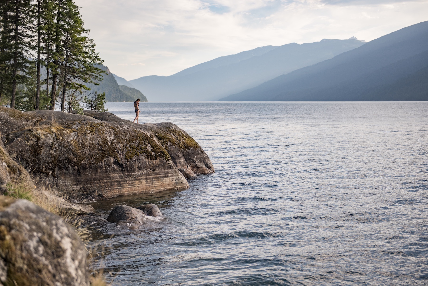
Set in a relatively steep-walled valley, there are great views of the surrounding Selkirk Mountains in all directions, especially from the middle of the lake. The west side is roadless with its southern ¾’s in Valhalla Provincial Park. Most people in kayaks or canoes stay on the west side. It has a relatively poor fishery, and the record 26-pound lake trout was a notable exception. I have taken four days for this trip each of the five times I have done it. I have also made several day trips to various beaches over the years. One year, I camped for 5 days at Wee Sandy.
I have always launched on the north end and taken out at the south end (obviously, one can start at either end). Both have good road access and parking. Except for the locals camping for a weekend on one of the beaches, one usually sees no one else doing this trip (which I always find amazing). Most large creeks on the west side have big waterfalls near the shore and sandy beaches. There are ten established campsites with picnic tables and pit toilets on the west side of the lake.
WEST SHORELINE (from north to south with mileages from the north end).
The launch at the north end of the lake is accessed via Bonanza Creek Road at the south end of the tiny village of Hills, a sparse collection of houses lining Highway 6. The land adjacent to the beach here is private, with several homes on the site of an old resort. After you launch, you can move your vehicle away from the beach and park along the road.
Wragge Creek Rec Site. 5 km. 50.049524, -117.456308. This road-accessible campground is only 5 km from the put-in. The vehicle-accessible sites occupy a small peninsula with a few tiny islands off the southeast corner. The main beach faces south. There is almost always a caretaker present who collects a camping fee.
There are four attractive walk-in/boat-accessible campsites in the trees at the south end. I almost always stay here on my first night, making for a short paddle day.
Valhalla PP boundary. 10 km
Wee Sandy Creek. 10.5 km. 50.004689, -117.416578. This has a lovely beach and camping area, my favourite on the lake. A trail to a lookout continues for 13 miles to Wee Sandy Lake and Mt Niord. The trail is not used much and has a steep headwall at the end. The Holt Cabin is about 9 miles away.
Wee Sandy Lake Trail.
Sharp Creek. 12.5 km. 49.977952, -117.401178. Good boat moorage with mixed rock and sand beach. Sharp Creek trail was rejuvenated in 2020 with complete clearing, switchbacks and rerouting. The old trail was 8 km, with a 1,380m elevation gain. Follow Sharp Creek to the ruins of an old cabin at 1,920m. The usual campsite was 1.8 km away and had a 240 m elevation gain beyond the trail’s end. The glacier is small, but the views down to New Denver are dramatic.
Sharp Creek Trail.
Nemo Creek. 19.5 km. 49.923907, -117.408202. This is the premier stopping point on the entire lake because of its multiple beautiful waterfalls, which are accessible by a good trail. There are campsites on the beach and above the beach. The trail continues for 5 km up to some large rocks called the Rock Castles and a cabin.
Since the 2024 wildfires, the campsite has been closed and the trail difficult to follow because of all the deadfall.
Nemo Creek Trail

Painted Photograph by Lucas Jmief
Cory’s Ranch. A nice beach with a few campsites. A good alternative if Nemo Creek closed. 49.902966, -117.422199
Cove Creek. 25 km. 49.883562, -117.443618. Excellent moorage, steep rock, and pebble beach, campsite. Trail not maintained – 3.5 km, elevation gain +282m, 2 hours. The trail starts behind the Cove Creek cabin on an old skid road and leads through impressive ponderosa pine.
Cove Creek Trail.
Indian Point Beach. 27 km. 49.867751, -117.451679
Ben Brown Beach. 28 km.
Evans Creek. 32 km. 49.826176, -117.481133. A large campsite is on the beach and in the trees. The trailhead for Beatrice Lakes is here and crosses the creek on a bridge above a large waterfall close to the lake. Little Cahill Lake is 4 km, Cahill Lake is 6 km, and Beatrice is 10 km from the lake on a good trail. The trail ends at Beatrice.
Cahill/Beatrice Lakes Trail
Pebble Beach. 35 km. 49.799275, -117.489220. Privately owned with several houses. There is a good pictograph at 36km.
Slocan City. 39 km. (pop. 296)
This is the end of the lake and the start of the Slocan River, which runs 156 km to join the Kootenay River. A large sawmill occupies the east side of the beach. Could you take out more to the west at the boat ramp? Parking is free and ample.
It takes 15 minutes to walk out to Highway 6 to hitchhike back to Bonanza Creek and your car. The last time I did this, I caught the first car and got a ride right to my vehicle.
Slocan City has a grocery store, restaurants, and a kayak rental company, Smiling Otter. This is also the trailhead for the Slocan Lake Trail that goes 9 km to Evans Creek. Free of snow earlier than any other trail in the spring, it is an early-season favourite with locals. The southern end of Valhalla PP is accessed from the Little Slocan Lakes Forest Service Road. There are world-class hikes to Gimli Peak and Mulvey Basin (Bannock Burn Creek Road), Drinnon and Gwillam Lakes under the Devils Range (Hoder Creek Road), and McKean Lakes (outside the park up Koch Creek).
EAST SIDE.
There are few campsites or public beaches. The highway follows the entire side, and most of the land is private.
Roseberry. 8 km. This is a small residential community with a good Mexican Restaurant. This is one of the few places on the lake (the other is near the hospital in New Denver) with detectable fecal organisms. It is built on the delta of Wilson Creek with a very shallow water table that requires expensive septic systems. Few homes deal with this special situation.
New Denver. 16 km. With 560 people, it is the largest town on the lake and has all services, including a marina and campground with a good beach on the south end of town. New Denver was the largest Japanese internment camp during WW2, and its Nikkei Centre is a great museum commemorating that terrible time. Some residents from the camp still live in ND today.
This area is a popular motorcycle touring destination. The Galena Trail, a rail line now converted into a nonmotorized trail, runs from Three Forks above New Denver along the east side of the lake ending in Nakusp. The famous Garlic Festival is held in September.
Silverton. 21 km. (pop.196) Another small community with a store, building supply, a small restaurant, and a good launching site at the south end of town. This would be the best launch site for Nemo Creek.
Bannock Point. 25km. Accessed by a 1.5 km road and a short walk, or by water, this is a great summer beach hangout on the rocks. Campsites.
DOES SLOCAN LAKE FREEZE?
Article excerpted from the Kutne Reader.
Slocan Lake never freezes, it is said. And while it’s true that it rarely happens, there have been several notable exceptions. The reason is that it is very deep, over 970′ south of Silverton. For the same reason that a thermocline forms in the summer (on hot sunny days, the top 3-4 feet are warm, and then you hit the cold layer that never goes away except in the shallowest bays.
I came across a map on the door of the Valhalla Pure Beach Shop in New Denver (pictured below), produced in 2016 and bearing the following statement: “Slocan Lake …only froze over 3 times in history! In 1970, 1950 and 1928.”

That struck me as unlikely. Well, perhaps it froze in those three years, but others as well. Or maybe ice formed in some years, but it didn’t freeze from end to end. So I couldn’t help looking into it. Below, I’ve enumerated each year ice reportedly appeared and the level of certainty with which I can say it did. Curiously, this is easier to do for earlier years than the more recent ones — a function of the fact that many 1890s and early 1900s newspapers have now been digitized, but not many from the mid-to-late 20th century. Ice was a big headache for sternwheelers, and the CPR’s response to it made the news.
The sources don’t always reveal how much of the lake froze, but for my purposes, it didn’t matter. It was an infrequent enough occurrence that any mention of ice appearing was enough to merit inclusion.
1898. Did the lake freeze? No. The evidence: The Vancouver Daily World claimed “the ice on Slocan Lake [is] in a dangerous condition, as it is full of air holes. A miner had a narrow escape from drowning.” But the Nelson Tribune of Feb. 19 pooh-poohed this: “Ice on Slocan lake has been an unknown quantity since history began.” To the Tribune, history probably began in the winter of 1891-92, following the start of the Silvery Slocan mining rush.
1899. Did the lake freeze? Yes. The evidence: The Ledge of Jan. 12, 1899, reported on
the most severe cold snap in six years, although it concluded, “There is no ice on Slocan Lake.” But by Feb. 9: “Ice on Slocan Lake is unusual, but there are tons of it floating about this winter.”
And on March 28, the Tribune reported: Ice on Upper End of Slocan Lake. William Hill, who is interested in a sawmill at the upper end of Slocan Lake, is in Nelson. He reports the ice so thick on the upper end of the lake that his firm will have to saw a channel through it to get out their tug and barge. This firm has been on the lake since 1892, and this is the first time ice has in any way interfered with its operations.
1907. Did the lake freeze? Yes. The evidence: The Revelstoke Mail Herald of Feb. 6 noted
The CPR was calling in ice breakers on the Arrow Lakes, and “To add further to the company’s trials and tribulations, a portion of Slocan Lake has frozen over …” The next day, the Slocan Mining Review added: “All old-timers concede that the present winter is the severest yet experienced in the history of the Slocan … From Slocan City, there are eight miles of ice, a hitherto unknown thing by the oldest longshoremen.”
1916. Did the lake freeze? Yes. The evidence: According to The Ledge of Feb. 10: “The oldest inhabitant has never seen as much ice on Slocan Lake as there is this winter.” And on March 2: “This winter there were eight inches of ice on Slocan Lake.” The Vancouver Daily World on March 7 added: With their waterways fast bound in the thrall of such an ice blockade as has never before been experienced in the interior of British Columbia, the Slocan and Nelson districts have encountered a winter which finds no precedent in the annals of old-timers.
Steamer and barge crews [on the Arrow Lakes] have toiled for five and six days on end without taking their coats off. It is only by these heroic efforts that it has been possible for the company to keep open a narrow strip 20 miles long, crossing Slocan Lake like a dark blue ribbon, with the broad white expanses of the ice field extending to the snow-covered shore on either side … This narrow channel is only the width of a barge, which is fitted with an ice-breaker and is pushed by a steamer from one end of the lake to the other.
1928. Did the lake freeze? Yes. The evidence: The Valhalla Pure map claimed this year was one of three instances where the lake froze. At first, I thought they were all simply off by a year and should have said 1929 (see below) but then I found this item in the Slocan Enterprise of Feb. 22, 1928: Owing to the cold nights and the calm weather ice has formed in large bodies on Slocan Lake, and some places is an inch thick. Monday morning, the ice field extended from Ten Mile to the head of the lake, with clear water showing near the creek mouths only.
 1929. Did the lake freeze? Yes. The evidence: This is the best-documented freeze-over. It received extensive newspaper coverage. According to a this-day-in-history item in the Arrow Lakes News of Feb. 15, 1989: “Men from the logging camps on the west side of the lake ran short of supplies and food for their horses. As soon as the ice was thick enough, they came across to New Denver pulling their rowboat on the ice and each carrying a long pole in case the ice broke through.”
Postcards were produced of this trek, dated February 1929, including the one seen below. (An alternative but probably incorrect caption, printed in Old Silverton, p. 237, suggested they were “hauling feed for Sandy McKay’s horses over at Wee Sandy Creek (Mill Creek).”

“Crossing Slocan Lake on the ice, Feb. 1929.” This photo is hanging in Slocan Community Hospital, credited to Hope George, with the caption: “Slocan Lake is frozen over the winter of 1928-29. This picture was taken just outside the CPR wharf at New Denver. This is a group of loggers taking supplies to their camp near Glacier Creek. They were running low on supplies for their camp and feed for the horses, so they waited until the ice was thick enough. Then, they put runners under their rowboat, and each man carried a long pole in case one of them fell through the ice. Note that on the way back, they are spaced out so there isn’t too much weight in one spot.”


The Slocan Enterprise of Feb. 13, 1929, reported: For the first time since 1916, skaters made a trip to Evans Creek and returned to the lake. E. Palmquist, D. Hird, John Greenwood, Pete Strand, and F.M. Hufty made the return trip in less than an hour last Wednesday.
Henning von Krogh quoted several accounts from the Arrow Lakes News in his recent book, The Boats of Slocan Lake. Feb. 15: The extreme cold spell of the last two months finally conquered Slocan Lake, and it is now frozen over solidly from Slocan City to Bannock Point, a few miles south of Silverton—the Str. Rosebery has experienced considerable difficulty in maintaining its passenger and freight schedule during the past week and has been several hours late on each trip. This is the first time in 13 years the lake has frozen over, and local skaters are taking full advantage of the sport it offers. Large numbers are out skating daily, with Sunday being especially popular, with no less than 75 people on the frozen expanse between here and Evans Creek.
Feb. 27: Ice conditions on Slocan Lake necessitate the routing of mainline traffic via Kaslo, and all regular traffic on the lake has been suspended for the present. The pickle-boat, Rosebery, is trying hard to keep the channel open but has hardly enough power to push herself through open water without bucking ice with a light barge. The last regular trip was run last Monday morning. Over 80 passengers were packed into the boat and kept there for over seven hours. The good ship took that much time to get to Rosebery on account of the heavy ice. Loaded barges have been too heavy for the tug to move through the ice, and as a result, the people up the lake have been unable to get in their regular goods and are also suffering from a lack of fuel. A freight train came in [to Slocan City] from Nelson Saturday and unloaded the barges, taking the freight back to Nelson from where it was to be shipped into the Slocan via Kaslo.
March 8: The ice punched a hole in CPR barge No. 30 on Slocan Lake last week, and only quick work on the part of the crew of the Str. Rosebery saved the barge from sinking. The hole was repaired, but the barge, which was being used as an ice breaker, is unfit to break ice again, and the new barge No. 14 is now being used for that purpose. The heavy ice continues to cause trouble, and the tug and ice-breaker spent 24 hours making the trip to Silverton last week, leaving here Friday at noon and arriving at Silverton Saturday at noon. It is expected that the mainline service via Slocan Lake will resume on Wednesday morning.
March 13: Service has been fully restored on Slocan Lake, and the boat is running within an hour or so of its regular schedule, although it handles an icebreaker on each trip. The warm weather the past week has softened the ice on the lake, and it is not likely that it will be hard enough to hinder the boat to any extent.
John Norris adds in Old Silverton, p. 233, that “All the mines had water trouble as pipes froze up and snow buried buildings. In April, Walter Sheeler reported … that ice had left the lake, although snow still made work difficult at the mines.”
1930. Did the lake freeze? Yes. The evidence: This was the third consecutive year the lake froze.

Again, I quote The Boats of Slocan Lake, quoting the Arrow Lakes News:
Jan. 29: The Rosebery broke her rudder stock in heavy ice on Jan. 8, only four days after the cold wave descended on the Kootenay. She was hauled up on the way at Rosebery; teams of horses were employed for this purpose, and a special crew rushed up from Nelson shipyard to make repairs in the shortest possible time. On January 15, she was relaunched and again in service, battling the ice and direct freight and passenger service between Nelson and the Slocan was resumed.
Under Captains Kirby and Reid, the latter from the Okanagan, who are relieving each other, the Rosebery is now going night and day and Sundays in an unremitting campaign against a great ice field that covers the lake for the lower 10 miles of its length. Saturday, she was practically frozen in the ice at Slocan City, but broke her way out.
Yesterday, the Rosebery made her regular trip from Slocan City to Rosebery, and last night started down with one ice-breaking barge with which to double the width of the channel so she can maneuver today with a loaded car barge on a northbound trip.
Since writing the above, news has come that the Rosebery got stuck in the ice a few miles north of Slocan, the ice proving too thick to combat …

Feb. 5: The people of the Slocan now have one of the largest and best skating rinks in the province. It extends from Slocan City to the head of the lake, about 30 miles, and is from one to two miles in width. It is perfect ice with occasional air holes. If the skater drops into one of the air holes, there will be no funeral expenses, as the lake never gives up its dead.
The tug Rosebery and a car barge are ice-anchored near Cape Horn, a few miles from Slocan City. A team is hauling coal to the Rosebery, and a gang of men have been put to work sawing a channel to Slocan City, some job with 10 to 12 inches of ice.
The Nelson Daily News of March 3, 1930, reported that ice was causing more trouble.
Ice conditions have again tied up boat service on the Slocan lakes [sic] between Slocan City and Silverton. Canadian Pacific Railway officials announced last night that the service between Silverton and Slocan City had been cut off. A service from Silverton and New Denver to Rosebery for connection with the train to Kaslo and Nakusp will be continued on Monday, Wednesday, and Friday of each week. Thus, a person wishing to reach New Denver and Silverton on the lake must travel via Kaslo.
The Daily News of Jan. 21, 1930, also wrote, erroneously, that “last year for the first time in recorded history Slocan Lake froze.” Memories were short, I guess, for it had frozen one year before that and in the least three other years since 1891
1937. Did the lake freeze? Yes. The evidence: From the Arrow Lakes News, Jan. 28, 1937, as quoted in the same paper of Jan. 18, 2007:
Yielding to the longest continuous stretch of zero and near-zero weather for several years, the Slocan and Arrow Lakes have frozen over. A week ago, the CPR steamer Rosebery was able to make its round of Slocan Lake points. Still, Wednesday saw a sheet of ice cover the lower end of the lake from Slocan City for 10 miles, while the upper end was also reported iced over, with the whole lake looking very still. By the end of the week, a thick sheet of ice surrounded the Rosebery and her barge up at their berth at Slocan City. The sailing of the Rosebery was cancelled on Monday, and alternative arrangements are being sought to provide freight service to Slocan Lake towns.
This story in the Calgary Herald of Feb. 1, 1937, identified five of the seven confirmed years to the point that the lake froze, missing only 1907 and 1928.

One other reference from The Vancouver Sun of April 12, 1937: “After several unsuccessful attempts in past weeks to break the ice on Slocan Lake between Slocan City and Silverton, the tug Rosebery made through to the lake-head town Wednesday and brought back a barge load.”
1938. Did the lake freeze? Undetermined. The evidence: The Arrow Lakes Archives has the following photo with this caption: “A view of the ice on Slocan Lake taken March 1, 1938, from CP wharf at New Denver. Ice 17 inches thick.”
 However, I checked the Nakusp Silver Standard for that period and found no mention of ice on the lake. This may be 1937.
1942. Did the lake freeze? Undetermined. The evidence: It’s well documented that the winter of 1942 was harsh, especially for Japanese Canadians interned in the Slocan Valley who lived in tents or hastily constructed shacks. Ron Hotchkiss describes it in Diamond Gods of the Morning Sun: The Vancouver Asahi Baseball Story: That winter, Slocan Lake froze. Between the end of October and the beginning of February, 82 inches of snow fell. The only paths were trenches that went to the nearest neighbour or the outhouse. Roads were blocked, mail was held up, and water pipes froze. Young people bundled up and, with ice skates dangling over their shoulders, trudged to the skating rink.
No mention of skating on the lake. This is the only reference I can find to the lake freezing in 1942. A search of the New Canadian newspaper turned up nothing.
1950. Did the lake freeze? Yes. The evidence: The Arrow Lakes News of Feb. 9 reported that due to the build-up of ice, the CPR “has placed an embargo on operations of steamers on the Arrow and Slocan Lakes until weather conditions permit easier operations.”
As alluded to by Sumi Kinoshita, the icing over of the lake led to tragedy: on Feb. 19, Maurice Gordon, 14, and Tommy Steele, 12, fell through the ice at Silverton and drowned. This story appeared the next day on the front page of the Nelson Daily News:

What is not apparent from the story above is that Andy Avison saved Sandy Harris and T. Nelson, who came to help, but got into trouble themselves. Avison was recognized later that year with the Gilt Cross. This is from The Vancouver Sun, Nov. 15, 1950.
 1957. Did the lake freeze? Yes. The evidence: In the second volume of his unpublished autobiography, Daylight in the Swamp, Irv Anderson recounts working aboard the tugboat Iris G: The weather turned very cold towards the end of that January … Now the lake was freezing enough so that we could use only the steel barge, which necessitated extra trips. One day, we were stuck for five hours off Cape Horn while we ran around with the light boat breaking new channels. I recall one freezing night we ran all night long in the channel to keep it open. We were relieved when the weather finally broke in mid-February, and the ice would dissolve under a warm south wind.
1970. Did the lake freeze? Undetermined. The evidence: All I have to go on is the Valhalla Pure map mentioned at the beginning. However, the Slocan Swami of Feb. 27, 1979, indicated the lake froze at some point in the previous ten years, so this may well have been the year.
1979. Did the lake freeze? Yes. The evidence: An ad placed by the Slocan Lake Stewardship Society in the Valley Voice on Feb. 6, 2013, stated: “Local folks say the last time the lake froze over in 1979 was because it was so calm-no wind causing ripples to break up the developing ice. The other two documented freezeovers were in 1950 and 1928.” Although we now know there were many more freeze-overs, 1979 does appear to be the last such event.
My mother-in-law sent me two remarkable pictures, seen below, both taken that year.


Henning von Krogh also found the following in the Slocan Swami newsletter: Jan. 16, 1979: [T]he lake is frozen over fairly solidly from Slocan up to the Silverton viewpoint, Silverton bay is lightly frozen, and there are pads of ice floating between Silverton and New Denver. In the ten years we have been in New Denver, this is only the second time that the lake has frozen so much …
Feb. 27, 1979: After the recent downpours, the lake is beginning to look decidedly smushy and slushy all over the place – once more raises the fascinating question of when the ice will go.
Summary. Ice has formed in appreciable quantities on Slocan Lake at least ten times since 1891: in 1899, 1907, 1916, 1928, 1929, 1930, 1937, 1950, 1957, and 1979. It may have also happened in 1901-02, 1938, 1942, 1948, and 1970. It probably didn’t happen in 1894. It did not occur in 1898.
