
Kootenay Lake is big, some 105 km long and up to 5 km wide. The Purcell Mountains are to the east and the Selkirks to the west of the lake. The West Arm of the lake flows west from near its centre, and just past the city of Nelson forms the Kootenay River again, which enters the Columbia 50 km north of the US/Canada border at Castlegar. There are six hydroelectric dams between Nelson and Castlegar. The lake is world-renowned for its lake trout fishery. A particular subspecies, the Gerrard trout, is a gargantuan species of rainbow, averaging 7-9 kg with a record of 23.4 kg. Its size is at least partly because its main diet is the landlocked Kokanee salmon.
This huge lake can make for challenging boating as it develops significant wind waves usually by the afternoon. The water remains relatively cold throughout the season, and thus, swimming is not that pleasant. The valley is wide, providing better views of the surrounding mountains with some of the best sunsets and sunrises in the WK. Four 1:50,000 maps cover the entire lake. From north to south, they are 82K/2 – Lardeau, 82F/15 – Kaslo, 82F/10 – Crawford Bay, and 82F/7 – Boswell. 82K and 82N 1:250,000 maps provide much less detail (there are sixteen 1:50,000 maps in each 1:250,000 scale map).
Due to its large size with well over 200 km of shoreline, it would not be easy to do it all in one go. It took me many 3-day weekends over a few seasons to see the whole lake. The west side of the bottom half and the east side of the top half are almost roadless. Camping can be more difficult on the sides of the lake with roads due to the many private properties.
NORTH END / WESTSIDE
Highway 31 runs along this entire shore but is rarely next to the water. The Duncan River enters the north end, adding silt and producing shallow water. It is easy to get high-centred here.
Lardeau. This tiny community has two boat launches (50.145436, -116.949826). Gerrard trout can be seen spawning in the Lardeau River in late April to early May.
Davis Creek Provincial Park (PP) on its south end.
Davis Creek Trail starts just north of the highway bridge and is a steep one-hour climb to a small grove of giant old-growth cedar trees.
Lost Ledges PP (50.102163, -116.939031) has a good boat launch on its north end and nice campsites, many on the water. I once parked here for 4 days and brought home a packrat that had taken up residence in my engine compartment. This is the last camping on this side of the lake until the small town of Kaslo, 22 km south.
Kaslo (pop. 1029) is in a gorgeous setting on the shores of the lake with otherworldly views of the Purcell mountains on the opposite shore. The striking peak to the SE is Loki, which only recently has had a trail built to the top. Kaslo has all the services, including a nicely restored hotel and the SS Moyie, a restored sternwheeler that is a worthwhile visit. The Kaslo Jazz Festival, with the stage on the lake, is held the first weekend of August. Camping may be possible at Kaslo Beach Regional Park (49.911031, -116.900562) near the sternwheeler. This is a good place to launch, camp at Lost Ledges, continue over the north end of the lake and then down the east side where there is much more camping. Then return to Kaslo to your vehicle for a nice 3-4 day trip.
Fletcher Falls Rec. Site 1, 8 km south of Kaslo (49.836824, -116.89842), has a day-use area and a small semi-open campsite on the lake. Parking is on the highway so that you may be the only camper.
Woodbury Resort and Jones Boys Marina, another 8 km south, have a restaurant and store.
Ainsworth Hot Springs (49.735434, -116.911239) has a jetty and a resort with the most popular hot springs in the WK. There is a warm pool and a horseshoe-shaped tunnel with hot water pouring off the roof, private “alcoves”, and a nice place to sit out of the water in a natural recess. Take a refreshing dip in the cold pool. This is a worthwhile diversion from kayaking.
Coffee Creek PP (49.696856, -116.907732) has a good forested campsite on the lake. The road access was washed out by a flood several years ago, so again, boaters are likely to be the only campers.
There are two other potential campsites between here and the West Arm at Balfour. One is at 49.668244, -116.920182, the second at the top end of Queens Bay just west of McEwan Point at 49.654596, -116.934232.
Balfour. One of the best launch sites on this side of the lake is at Balfour Beach Regional Park at 49.628259, -116.946496. This can be somewhat difficult to find; wander around the roads to the most easterly part of this small town, there is ample free parking here.
Just inside the West Arm, Balfour is the western terminus of the Kootenay Lake Ferry, the longest free ferry in the world at 9 km.
NORTH END / EASTSIDE
Argenta is a small town right at the north end of Kootenay Lake has a good boat launch again with good parking (50.167754, -116.922926). There is a lovely beach at 50.172019, -116.923625 where one could wild camp. Its original settlers included many Quakers who came in the early 50’s. There are no businesses here.
Earl Grey Pass Trail ends here.
The road ends at the tiny community of Johnson’s Landing (pop. 35). A massive landslide came down Gar Creek, engulfing three homes and killing four people in July 2012.
Fry Point at 50.059203, -116.877927 has a large campground on its north side. It is owned by the NW Society of the Unitarian Church, which was formed solely to purchase the land and preserve it. There is a caretaker present throughout the summer, and a fee is charged.
Fry Creek has a dramatic canyon upstream from the point with a footbridge. The trail continues to Birchdale.
The Purcell Wilderness Conservancy includes the lakeshore for 6 km here.
Birchdate. Home to St. John in the Wilderness, a small Orthodox Christian sanctuary devoted to nature, beauty, and human resilience. We come together to practice, chant, and experience the Orthodox Christian Liturgy in an off-grid chapel in Birchdale. Many of us are new to Orthodox Christianity or converts to the faith.
Fr Nilos Nellis and M. Sheila Murray-Nellis came to be the caretakers of this breath-taking, pristine land in 2006. Those of us who come here to learn and grow and worship feel so blessed to be able come together here in communion with each other and the elements in the natural beauty of the Purcell Wilderness Conservancy. They are on their way to building a stone sanctuary with the foundation finished in 2024. There are ten acres of gorgeous land, cabins, and all the tools necessary
Kootenay Lake PP – Campbell Bay Campground 49.953801, -116.865319 is SE of Verandah Point and has nice beach campsites. The Clute Lake Trail departs from the back of the bay. Two km south at 49.938250, -116.860373 is the Leviathan Lake Trail. There are pictographs on the lakeshore at 49.906284, -116.876510 (directly opposite Kaslo), and at 49.902793, -116.870698.
Powder Beach Recreation Site. 49.892729, -116.869292.
Garland Bay Rec Site is a semi-open medium-sized drive-in site (albeit at the end of a long logging road) with two campsites on Bernard Creek at 49.869959, -116.859881 and a non-drive-in site on the south side the main point at 49.866033, -116.861450. These are heavily used in the summer.
Pebble Beach Rec Site 49.809139, -116.855673’ is a small walk-in or boat-in site with a pebble beach!
Riondel (pop. 400). The small village of has the Riondel Community North Bay Campground at the north end of town 49.768370, -116.859220. There is a store, a restaurant, and a medical clinic. Avoid Galena Bay at the south end of the city, as it is rocky and further from the amenities.
Yasodhara Ashram. The famous ashram has a large white dome at Walkers Point 49.708306, -116.865261.
It is possible to camp under the huge power line crossing the lake. The east side of the free ferry, part of Highway 3A from Balfour, is at Kootenay Bay.
Pilot Bay PP occupies a small peninsula, and the land across Pilot Bay, near Sawmill Cove. It has many great hiking trails. A good boat launch site is at 49.646234, -116.877429.
Tipi Camp. Owned by a non-profit organization (the Guiding Hands Recreation Society), it is just NW of Cape Horn and accessed by boat usually from Grey Creek, where there is a store and boat launch. It hosted many groups through the summer including a great yoga retreat at the end of August.
As of 2020, it is not operational, but it is still a great place to camp.

SOUTH END /EAST SIDE.
Highway 3A runs down this entire side of the lake, significantly limiting camping possibilities. This section of highway has been voted one of the premier motorcycling roads in Canada.
Lockhart Beach PP. 49.508775, -116.787523. Even though this is a “beach” park, there is no camping on the beach! The only camping is in the campground across the road, a long walk. The one time I camped here, I set up my tent on the beach and eventually stayed when the host gave in to our whining.
Mackie Beach Park 49.469399, -116.768027. The beach is rocky and has picnic tables, BRs and a small parking area.
Boswell Public Boat Launch 49.461447, -116.766039
The Glass House. 49.404961, -116.741315. A pioneer in the area built a fantastic house out of embalming bottles. It is worth a visit.
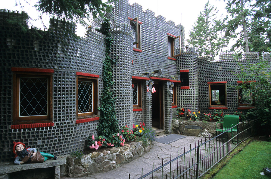
This unusual roadside attraction was built from over half a million discarded embalming fluid bottles.
In 1952, David H. Brown retired after 35 years in the funeral business. It occurred to Mr. Brown that there should be some practical use for the bottles. And, it all started, to quote Mr. Brown, to indulge a whim of a peculiar nature. Mr. Brown travelled western Canada collecting bottles from many of his friends in the funeral profession until he had acquired 500,000 of the square-shaped bottles, weighing 250 tons in all.
Built in a cloverleaf pattern with three main rooms, circular in shape, 48 feet in length, 24 feet wide, and with an upstairs room, it contains 1,200 square feet of floor space. The house itself sits upon solid rock.
Entering the grounds, the visitors are welcomed by a mountain stream trickling over a moss-covered water wheel, which brings to life the dwarf inhabitants nestled around the wishing well. Over 320 dozen flowers border pathways and entice visitors from the terrace over a bridge also built of glass bottles. A winding path beneath the bridge leads to the rocky lakeshore and a lookout called the lighthouse, which offers a spectacular view of beautiful Kootenay Lake. Tours of the estate are available seven days a week, from May to October. A gift shop is also located on the property. It is 40 km (25 mi) south of Crawford Bay on the shores of Kootenay Lake.
Sanca Campsite. The best place to camp on this part of the lake is on a lovely open, small sandy public beach at 49.388764, -116.734835. There is no table or toilet. This is also a reasonable launch site.
Redman Point. Beach south of the point at 49.329211, -116.706679.
Kuskanook. This marina is the only good launch site on this section of the lake. The parking requires a fee. This is 2 km north of Kuskanook PP.
Creston Valley Wildlife Management Area. Although this is not kayak accessible and is best visited by car, it has great walks and blinds to observe birds.
SOUTH END / WEST SIDE
There is no road on this part of the lake, but the CPR rail line follows close to the shore of the entire side. The water in all the creeks (except possibly Next Creek) should be perfect. There is an interesting petroglyph panel at 49.283910, -116.737576 (Cattle Petroglyphs). From south to north, the available sights and camping opportunities are as follows.
Next Creek Rec Site. 49.301646, -116.760997. This is a small boat-accessible campsite that may be heavily used in the summer.
Tye Creek Rec Site. 49.325551, -116.785633. There are two boat-accessible lakeside campsites. There are houses here, and the south side is also accessible by road, but through private land (contact Darkwoods Forestry Ltd in Nelson for permission). The one time I stayed here, the mosquitoes (generally uncommon) were terrible.
Midge Creek Marine PP. 49.375053, -116.803852. This is a large, open campsite with a great sandy beach.
Drewry Point PP. 49.418863, -116.812168. This campsite in the trees has good beach access on either side of the point and is only 4 ½ km north of Midge Creek. Another small beach is just north at 49.425766, -116.815343.
Other small beaches are at 49.453892, -116.838069 (gravel).
Daveland Landing. Another small but very nice beach with possible camping at 49.491720, -116.842533.
Irvine Creek Recreation Site. 49.607094, -116.895784. Another good spot to rustic camp is a rock beach about 4 km SE of the West Arm of Kootenay Lake.
WEST ARM
There is often considerable current at the entrance to the West Arm. It is 33 lake km from Nelson. This makes for a nice but very long day trip where one has all kinds of opportunities to get a view of the highest-priced real estate in the WK. Highway 3A follows the entire north side of this portion of the lake. The south shore has the ferry-accessible communities of Proctor and Harrop. In Nelson, the best take-out point is Lakeside Park right after the big orange bridge.
Kokanee Creek PP. This large lakeside campground is bustling in the summer, and reservations are recommended. It makes a good halfway camp to split the West Arm into a two-day trip.
Kootenay River. Immediately after Nelson, the West Arm turns into a river and goes through Grohman Narrows with some turbulent water. Just after Highway 3A crosses the river is Taghum Beach on the south shore, offering a good launch and take-out point, and ample free parking. It is a nice kayak down to the first dam, about 9 km from Taghum Beach. There are four more dams, and then the only other reasonable place to kayak is the 17 km stretch between South Slocan and the Brilliant Dam just before Castlegar. The only put-in is just downstream from the Glade Ferry. Mostly lake, there are a few places with appreciable current, especially in the upper end. The beauty of hydroelectric power is that it is simple to ramp up power production for peak periods when the current will be most significant.
