
KASLO & SLOCAN RAILWAY – 53kms
The K&S Railway was a 3 ft (914 mm) narrow-gauge railway between Kaslo, Slocan, and the mining community of Sandon between 1895 and 1955, totalling about 53 km (33 mi) of track. It was operated initially by the Great Northern Railway and later by the Canadian Pacific Railway.
Kaslo River Trailway. Heading further east from Sandon, you can try to follow the Kaslo River Trailway, an abandoned rail corridor between Kaslo and Three Forks. Some of the railway has been converted to a trail, while other sections are now forestry roads, and some have been abandoned. Maps show an approximation of the route and should be used with a high degree of caution. Use the road route when in doubt.
When combined with the Nakusp & Slocan Rail Trail, the entire corridor (including road connections) is approximately 94 kilometres between Nakusp and Kaslo.

History
After silver was found in the mountains near what is now known as Sandon in 1891, several investors obtained a provincial charter in 1892 to build a railway between Kaslo and the new mines. Kaslo, on the shore of Kootenay Lake, was served by steamers connecting with railways near Creston and Nelson, British Columbia.
The railway was built west up Kaslo River to the pass with Seaton Creek, and passed across the hill above the boom town of Three Forks to Sandon. The Canadian Pacific Railway had already reached Three Forks in late 1894 by building from the west of Nakusp on the Arrow Lakes with its Nakusp and Slocan Railway. Both railways reached Sandon in late 1895.
Construction on the railway started in 1895 after obtaining financial backing from the Great Northern Railway, which was seeking advantages against the Canadian Pacific Railway and traffic for its mainline at Spokane. Great Northern had gained control of the Nelson and Fort Sheppard Railway in 1893, which gave it access to Kootenay Lake. Great Northern bought out the original investors in 1897, making the railway part of the Great Northern system under the Kootenay Railway and Navigation banner. Much of the ore from the K&S was shipped to US smelters, providing traffic for the GN.
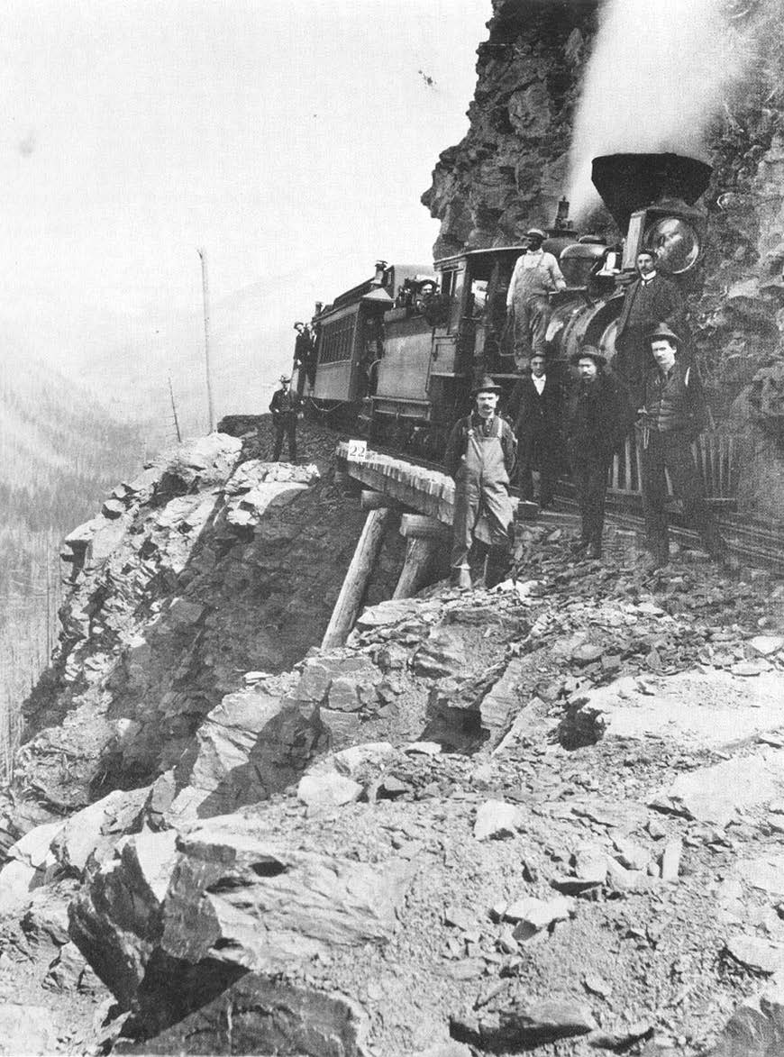 The immortal photograph taken by RH Trueman of the K&S train on Payne Bluff near Sandon
Anyone who’s a Kootenay history buff has seen it: the classic photo of a locomotive poised a thousand feet above the valley floor at Payne Bluff, taken in 1897 by photographer Richard H. Trueman. The story of the building of the Kaslo & Slocan Railway (K&S) by the Great Northern Railway is one of both accomplishment and disaster. And it’s a reminder that no matter how great our works, Nature remains the master.
Picture the scene: a gang of about 20 railroad labourers equipped with nothing but hand tools and dynamite, following the steep grade up Payne Mountain, near Sandon. With pickaxes, they chop out a path for the crew laying ties and tracks behind them. The narrow gauge track – a three-foot span instead of the four-foot, 8.5-inch span typical of the CPR – is well suited to the precarious terrain. The crew must build more than 30 trestle bridges between Kaslo and Sandon, a monumental task given the rudimentary tools. As a friend of mine said, “People then had to be built of tougher stuff than we are today.”
The K&S line featured a total of 33.4 miles (53.7 km) of track, with a three-mile (4.8 km) spur from Sandon to Cody. It began service on November 20, 1895. “From the terminus at Kaslo, the line gained altitude quickly using a switchback, then followed the Kaslo River past Fish and Bear lakes, climbing up the side of the mountain until it reached the site of Zincton. Old-timers claimed that if the stumps got too large, the K&S line ran around them,” wrote Hearne and Wilkie in Canadian West magazine. “From there, the going was tough, and Payne Bluff, with its sheer drop of 1,080 feet, was rounded on a rocky ledge, with a ‘grasshopper’ trestle, just before reaching Sandon.” It’s fitting that Payne Mountain was the scene of this engineering triumph. It was there that Eli Carpenter and Jack Seaton staked the first silver-lead claim in the Slocan mining district on September 9, 1891.
The news sparked a massive influx of prospectors and mining capitalists hoping to get rich. By the following year, 750 more claims had been staked. Before the completion of the K&S Railway in 1895, miners had only one way to get the ore down the mountains: by ‘rawhiding.’ Using bundles made of animal hides, miners filled them with ore and then used horses to haul them down the steep trails to ore wagons. You can imagine how dangerous this would be, especially in wintertime.
From there, wagons would haul them to steamboat landings at Kaslo or Rosebery. You can imagine the miners’ exhaustion after hours and hours on bone-jarring wagon roads. This costly, labour-intensive method was later replaced by aerial tramways at the larger mines, sending ore carts on steel cables down the mountain in a fraction of the time. “Because the Slocan district held so many different varieties and grades of ores, smelting them was a difficult process,” explains the Sandon Historical Society. “As a result, many of these ores had to be transported to smelters at Trail, or even further afield in Washington state.”
In 1896, its first full year, it made more than 500 round trips carrying 23,734 tons of freight and 28,307 passengers. Its principal function was to carry ore from the mines to the steamboats at Kaslo.
Hoping to get in on the action, the Canadian Pacific Railway’s Nakusp & Slocan Railway was built from the Slocan Lakeside, reaching Sandon within weeks of the K&S. Competition between the GNR and CPR was fierce. In 1895, when the CPR built a station there on land claimed by the K&S, its employees wasted no time in retaliating. A heavy cable was slung around the CPR depot and attached to a K&S locomotive, which then pulled it into Carpenter Creek. A newspaper report at the time stated that “Oldtimers still recall with glee when the little line, with a stout cable and a snatch block, snaked into smithereens the brand new depot building of the big company…” While it lasted, the silver-lead boom in the Slocan kept both railways busy, serving as both freight and passenger lines. “The K&S was justifiably proud that it was able to offer service between Spokane, Washington and Sandon in less than 12 hours, a fact that made delicacies such as oysters a possibility in remote and rugged Sandon,” notes the Sandon Historical Society. Both railways competed with building spurs to service mines to obtain ore traffic destined for the other railway.
The K&S was very profitable in the late 1890s. But as with all resource booms, the writing was on the wall for the end of an era. The CPR’s purchase of the Trail Smelter, combined with increased American tariffs on ore imports and crashing commodity prices, steadily whittled down the profit margin. The railway had high operating costs because of its location along the sides of steep hills, many of which had been burned in forest fires. Snow slides, avalanches and the annual spring washouts drove maintenance expenses sky-high. In 1900, Sandon burned to the ground, and labour problems at the mines spelled an end to the boom years, causing financial problems for the railway. By 1904, the line was losing money on each train it ran. In 1908, service was suspended to Sandon, with trains only servicing as far as McGuigan because expensive repairs needed to be done to bridges damaged by spring slides. While the track was rebuilt, service was never restored. In 1910, a severe forest fire burned many of the remaining major bridges and snow sheds. This finally bankrupted the K&S Railway. The GNR abandoned the line, prompting calls for the revocation of their charter and its accompanying land grant.
The CPR. In 1911, GN sold the railway to Kaslo business people and local mine owners who revived the line enough to ship ore from the pass near Bear Lake down to Kaslo. With backing from the provincial government, in 1912, the CPR agreed to lease the K&S for 999 years. The CPR rebuilt it to standard gauge and connected it with its existing Nakusp & Slocan line by abandoning the exposed section across Payne Bluff and building a 6-mile extension from Zincton to Parapet, thereby establishing a line from Nakusp through to Kaslo in November 1913.
The region had a moderate boom during World War I with the increased need for minerals, but otherwise experienced a gradual decline in rail tracks. The CPR operated the line until it was abandoned. The final blow came in 1955 when torrential rains washed out a large section of track at Three Forks. Ore traffic had been dwindling for years, and the CPR decided not to rebuild. Its right-of-way was used to build a new road to New Denver.was severed in 1955 due to flooding.
Route. The railway climbed steeply (3.35%) out of Kaslo to the first bench and then the pass at Bear Lake. The present Highway 31A out of Kaslo closely follows the Kaslo River and is mainly on the old roadbed of the railway. The railway bed is visible at several points along the present road, and in some places, even the ties and rails remain.
7.4kms. Keen Creek Road comes in from the south,
7.6kms. The crumbling remains of Nashton, earlier known as South Fork or Zwicky, an early settlement where the South Fork of Kaslo Creek joins the mainstream, were laid out in 1892. It was the shipping point for the Cork-Province Mine. It was renamed Zwicky by the CPR after 1914. We, Zwicky, came to Madison, Wisconsin, in 1900 to manage the mine. When it closed in WWI, he reworked the old Krao mine at Answorkth and the Silver Bell in McGuigan Basin. He was chairman of the Hospital board for 20 years and was never a patient until he was admitted for ptomaine poisoning in 1929. To the right of the road at this point is an old mine shaft.
24kms. Sproule’s or Blaylock’s. Sproule’s was a station on the K&S and became Blaylock in 1914 when the CPR took over. It commemorated Selwin G Blaylock, who joined the Canadian Smelting Works (later Cominco) in 1899. He became Cominco’s president and CEO.
27.5kms. Retallack, originally called Whitewater, is marked by a cluster of old buildings by the road. Originally staked in 1892 for iron, it was valuable for galena. There was a concentrator here, two general stores, a bakery, a laundry and bath, Whitewater and Victoria Hotels and the Jackson House built for railway workers. The train came through several times a day.
Unfortunately, in the hot summer of 1910, a small blaze that started near New Denver was fanned by high winds and carried up Carpenter Creek Valley. My buildings in Rambler Basin and at McGuigan Camp went up in flames. At the Lucky Jim Mine, five lives were lost, and much of the Kaslo and Slocan Railway was destroyed. The approaching fire was seen in Whitewater in time to enable 36 people to take refuge in the mine tunnel. As the blaze roared past, the concentrator, mine buildings, houses and businesses became ashes. So hot was the inferno that the rails on the K&S were twisted.
Most everything was rebuilt, and it was renamed Retallack. After the mine operated intermittently, it was active again from 1943 to 1952 during WWII. The town was subsequently abandoned.
Bear Lake City. In a hollow at the summit of the pass, 3,503 feet above sea level, were the two tiny lakes full of fish and bears found by Andy Jardine. A log cabin was built in 1892 to supply the Lucky Jim and several nearby promising claims. Lots were laid out, but the shanty hotel and a few other buildings were destroyed in the 1894 fire. In 1897, only the rebuilt hotel/post office/store remained. As the mines slowed down, the owner grew potatoes and chickens for the miners. Today, it is a rest area on the highway.
32.7kms. Zincton with some remains. Named for the mineral it yielded, the mine was opened in 1892 and was worked sporadically for about 70 years.
From Bear Lake, the railway stayed level as it rounded Payne Bluff above the ‘Three Forks’ confluence and on to Sandon on Carpenter Creek.
McGuigan. From Zincton, the K&S snaked around the sheer 1,000-foot face of Payne Bluffs. Before reaching the rocky ledge, the line crossed McGuigan Creek, and a siding was built to serve a large number of mines. In 1892, the province’s most precarious townsite was built – the McGuigan, Crossroads and Kaslo-Slocan Hotels, a store and a freighting camp. A May 1902 snowslide swept away the stables, 16 mules and horses, and wagons and one man was killed, but McGuigan was spared.
40.1kms. Three Forks. At the junction of Kane, Seaton and Carpenter Creeks was this important supply town, boasting six hotels and several businesses. Today, there is little to show that it ever existed.
Branch lines served the Cody mines higher up the valley above Sandon. The Riblet tramway brought silver ore down to the mill and K and S siding. The line suffered from several steep sections and tight curves.
