
TIPS & OBSERVATIONS
1. Currency. Denominated Turkmen Manat (DTM). 1€ = 4.1 DTM
This is a black market money country – the official rate is 1$US = 3.5 DTM.
The black market rate is $1 = 18 DTM. As a result it would mean losing over 80% of the value of your money if you withdrew any money from an ATM or bank. As a result if you come to Turkmenistan (or any of the other black market money countries like Uzbekistan or Venezuela), you must bring all your money as cash – $US or € – depending on the money used in that country or the one that receives the most favourable rate. In Turkmenistan, € and $US have the same value, so here it makes sense to only bring $US.
Always bring your cash in the highest denomination possible, at least 50s and 100s are better yet. Often small denominations can’t even be exchanged.
2. Smoking is illegal everywhere except in private homes and restaurants. People smoke in their cars with the windows rolled down but its legality is a gray zone. Spreading ashes on the ground is prohibited.
A funny thing happened at the airport when I arrived. My guide had not arrived and I was hustled by a taxi driver, but wanted a smoke. He took me to his car way out in the parking lot and I smoked inside expressly with the door closed. I returned to the terminal and he demanded $20 for the privilege of smoking in his car. If I would have known about all the hassle, I would not have bothered. The police give tickets of 100 manat (about $6) if found smoking.
3. Ashgabat. There are some odd rules: no black cars, people who live outside Ashgabat can’t drive into the city, must park outside and take a bus or taxi in (need to have license plates with AH or AG to enter).
4. Freedom. There is no free speech, freedom of the press and no ability to demonstrate. All the media and press is government owned and controlled. In elections, the leader wins with 96%. Web sites that are blocked are Whatsup, Twitter, YouTube, Facebook, Wikipedia, Instagram, MapsMe and Google Maps. For social media, they use IMO which is blocked in the US. Surprisingly even Bridgebase Online and Nomad Mania are blocked. VPNs are blocked unless you purchase high value ones.
The general population is often content if there is peace and they have a job. Freedom of speech is not valued.
5. When cotton is ready to be picked in September and October, all government employees must go pick cotton on their weekends. Many hire someone else to do it. Students no longer have to pick cotton. As cotton matures over times, each crop is picked three times – a very labour intensive job.
6. Corruption. It is tolerated if you benefit through family or friends or friends of friends.
7. Tree plantations are common but not doing well. Drought tolerant trees were not planted and they are not watered.
8. Turkmenistan has 1 million camels, 5 million cattle, 20 million sheep and goats and 5 million people.
9. Dress. Grade schools (green dresses) and university students all wear uniforms. In university it is a dark suit, round cap, women in long red dresses.
Women wear a traditional long dress and head gear, a colourful, patterned wrap that goes around their hair if married, a small round cap if single. Traditional male dress is a beard and a `big black sheep skin hat.
10. Religion. Turkmen tend not to be active practitioners of Islam. Only about 20% go to mosque and pray. The usual Islamic requirement of virginity at time of marriage is not practiced. Unmarried women are often sexually active. Men are often sexually active outside of marriage. I talked to one guy who had a girl friend in many towns.
Turkmenistan – South – Ashgabat, Ahal, Mary October 24, 26-28, 2019
October 24, 2019. I flew to Ashgabat from Tehran via Dubai on Fly Dubai .
We sat on the Tehran runway for 1½ hours because of some document problem. Dubai International Airport is mammoth but complete with many food choices, shops and great fast wifi.
The flight left Dubai at 23:55 full of Turkmen returning form Dubai where they buy products and resell them at home – electronics, car spare parts, perfume and clothes. Lineups are long with all this stuff, but simply walk around them to avoid the queues.
Turkmen women wear different brightly coloured headgear- more like a cloth wrapped around the back of the hair like a turban. It is not a traditional hajib-style headscarf. Many of the older people had a mouth full of gold crowns, but this is no longer popular.
Murad, my guide was not at the airport yet as I went through immigration quickly getting to arrivals at about 4am.
We drove most of the way to Nohur, stopped at the side of the road and slept in the car for a few hours.
NOHUR. About 2hrs from Ashgabat is this village that fills a small depression valley in the mountains of the Kopet Dag Range – villages in the mountains is unusual in Turkmenistan. The houses are been built with local boulders cemented with mud. Nohur is the largest village of this type with about two thousand people. Originally from the Khiva, Uzbekistan area, they remain isolated, have their own dialect and tend to marry within their tribe. They raise goats, sheep and cattle, grow grapes, pomegranit, apples and melons.
We drove the narrow dirt lanes of the town between the rough, dry stonewalls some covered with adobe. The main street had several rustic market stalls selling melons, jam in pop bottles, at least 25 different herbs and a red berry that is boiled and added to tea.
Gyz Bibi Shrine. Legend says there were 9 sisters, “half angels” living above the town. When attacked, they prayed, the mountains separated, they entered, the mountain closed and they reappeared in 9 different parts of the country, each now with a shrine. We walked up the cement steps to the very simple rustic shrine. Rough cream bricks topped with a metal cone roof above a tiny tunnel disappearing into the mountain. This is a sight of pilgrimage.
Graveyard. The wood post gravestones each have the horns of sheep or ibex attached to the top. This is an old Greek tradition derived from whom they claim as ancestors – original soldiers of Alexander who settled here.
There are 4 mausoleums above the town.
Kow-Ata Underground Lake. At the bottom of a long, descending 250m long cave, this lake is a constant 34-38°C and contains many elements: iodine, bromine, sulfur, chlorine, magnesium and potassium. The lake is about 25m x 10m wide and varies from 15-25m deep. People come here to swim and soak as it is reputably good for arthritis, skin diseases and colds. There is a faint rotten egg smell. Descend 170 steps and 55m down cement stairs to the lake. There are two platforms with changing areas.

Gok–Teke Horse Farm. The Akhal-Teke horse is the national horse of Turkmenistan and revered in the country. There are a light horse with longer, thinner legs, head held high, ears upright, , short hair, thinner elegant body originally bred to be fast, light and quiet on their feet. Their gate is described like a ballerina. They were used in everyday life but also in war. They come in all colours but tend to have darker legs. They are well trained, love to pose, roll over and stand on their hind legs. They are also thought to be emotional, cry and get very attached to their owners. It is illegal to eat akhal-teke horsemeat (unlike the rest of Central Asia where horsemeat is common) or drink horse milk. They are buried in graveyards often.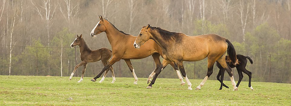
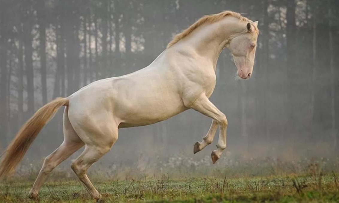
They are protected by the state and until January 2019, could not be sold outside the country and now only males. There is an annual “most beautiful horse” competition in Turkmenistan with the winner getting a new car. In 1934, a marathon from Ashgabat to Moscow took 80 days. There are horse races with 800m, 1200m and 2,800m distances.
Every larger city has a hippodrome (horse race track) where only these horses are used. They are extremely expensive – an average horse costs the same as a SUV and comes with a passport listing its bloodlines.
ASHGABAT
Ashgabat, formerly named Poltoratsk between 1919 and 1927, is the capital and the largest city of Turkmenistan in Central Asia, situated between the Karakum Desert and the Kopet Dag mountain range.
The city was founded in 1881, and made the capital of the Turkmen Soviet Socialist Republic in 1924. Much of the city was destroyed by the 1948 Ashgabat earthquake but has since seen extensive renovation under President Saparmurat Niyazov’s urban renewal project. The Karakum Canal runs through the city, carrying waters from the Amu Darya from east to west.
Ashgabat is the most white city in the world and has more marble than any other city in the world – the façade of virtually every larger (usually 4+ story) building has a white marble façade and a green roof. At night all the buildings have LED lights in moving rows, vertical lines and front lighting. Business names are tasteful large LED displays on the roofs. It is actually more spectacular at night. Businesses have simple LED display signs with the name only and the function (eg restaurant) is not mentioned. Even the Soviet era apartment buildings built in the 1980s and facing the main streets were reclad in white marble. New Ashgabat consists of many 11-12-story apartment buildings with expensive “elite” apartments, Jacuzzis, swimming pools and gyms. Some are owned by rich people but are also available to government employees with a subsidized 30-year mortgage. There is a Pushkin Russian school, Puppet Theatre with gold onion towers and the International University of Humanity Development.
See the separate post on Ashgabat for more information.
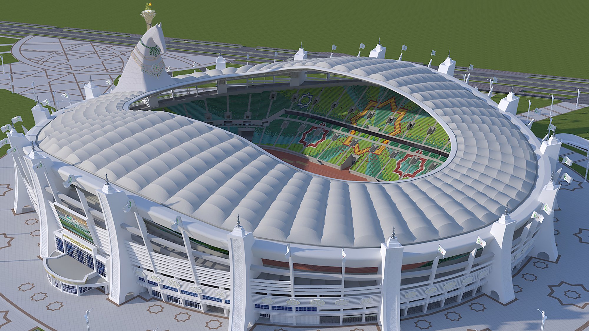
Ashgabat International Airport. This is a stunning airport with a giant bird and moving LED lights forming the main facade. It is even attractive from the runway side.  Olympic Village complex built for the 2017 Asian Martial Arts Games was a 5 billion expense and of spectacular construction – a big stadium (with a huge horse sculpture – the largest horse in the world – with an “Olympic flame” standing on his mid neck), 2 hotels, big indoor swimming pools (with 3 pools), velodrome, tennis courts, basketball facilities, indoor athletics (gymnastics), international broadcasting center, on and on. The airport was also completely rebuilt with lovely architecture – easily the best looking façade of any airport I have ever seen. The airport is also inside the city making it very convenient.
 Ashgabat Monorail. Only operated in the Asian Games of 2017, it connects venues in the Olympic Village. It is about 3kms long. At night, the section over the main road is lit by Olympic rings.

Roads. All the major streets in Ashgabat are 8-lane divided with 2 “access” streets on both sides – ie 6 lanes on each side! All vehicles from outside Ashgabat cannot be driven into the city, must be parked outside and then take Ashgabat registered vehicle into the city. This is amazing as the streets have little traffic. There is no parking on any major street and finding parking to access sights difficult. All vehicles in Ashgabat should be white or very light colours – if not they must be repainted. Licence plates are white (normal cars), blue (businesses) or yellow (diplomatic).
Gas is 1.5 manat per litre (about €.43/l), diesel 1.3 manat per litre, one of the cheapest in the world. It is heavily subsidized by the government (generally a mistake economically). They have developed, with Japanese technology, the ability to produce car gasoline from natural gas, of which Turkmenistan has the 4th largest reserves in the world.
Karakum Canal is one of the largest irrigation and water supply canals in the world. Started in 1954, and completed in 1988, it is navigable over much of its 1,375-kilometre (854 mi) length, and carries 13 cubic kilometres (3.1 cu mi) of water annually from the Amu-Darya River across the Karakum Desert in Turkmenistan. The canal opened up huge new tracts of land to agriculture, especially to cotton monoculture heavily promoted by the Soviet Union, and supplying Ashgabat with a major source of water. The canal is also a major factor leading to the Aral Sea environmental disaster.
The current Karakum Canal was not the first major attempt to bring the Amu-Darya water to the Karakums. In the early 1950s, construction began on the Main Turkmen Canal, which would start at a much more northerly location (near Nukus), and run southwest toward Krasnovodsk. The canal would have used around 25 percent of the Amu-Darya’s water. The works were abandoned after the death of Joseph Stalin, the current Karakum Canal route being chosen instead. Reservoirs such as Hanhowuz Reservoir were created to help regulate it.
Monuments. There are so many grand monuments, most in the center of roundabouts, that people have forgotten the names of most of them. They have fountains, statues and are all lit up at night. For example, one is a stainless steel octopus surrounding a gold ice cream cone.
Street light standards. There are many different designs, all have 2 lights or one light and a lit base, are white and usually have a lot of gold embellishments.
Police. There is a policeman on every corner. Wearing a Soviet-style high peaked hat, none have weapons (the only place with guns in Ashgabat is in the US Embassy). But they give out tickets for smoking and direct traffic. One of the major hassles of Ashgabat is that roads are constantly being closed for the president and delegations of ministers or foreign delegations moving through the city. There are more policemen than citizens on the street.
Speed Control Gantries. Every major street has periodic speed camera gantries controlling the speed to 60kms/hr.
We went out to eat at the large shopping centre a 4-level modern mall. After we caught the train at 19:30 to go to Balkanabat in Turkmenistan – West – Balkan Province. We had 2 bunk beds in a 4-berth compartment sharing with a family from Mary. He taught violin at the music academy there. They had pomegranites from their garden and were a lovely couple, but spoke no English.
GO TO Turkmenistan – West – Balkan
We returned from Balkanabat in the afternoon of October 26, a 4½ hour drive in a hired car. The hotel was the Menzil, an ultra modern hotel next to the lovely bus station that had just opened. Along with a Swedish woman also traveling with Murad, we were the only guests. They had no wifi.
The next day, she went to Mary with another guide and I saw Ashgabat.
Day 2
Shrine of Seyit Jamal addin (Seyit Jemaleddin). Within the Annau Archeology site is the shrine.
He was a nobleman and teacher (his son was a vizir (minister in the government) in Khiva who constructed the mosque in the 15th century). It was totally destroyed in the 1948 earthquake (a 9.0 earthquake at 1am on October 6th with the epicenter in Ashgabat where 178,000 or ⅔ of the population of Ashgabat were killed and only 3 buildings in the entire city survived – a train station, mosque and the headquarters of the Communist Party), but is still a very popular pilgrimage site for Turkmen. All that remains are a few columns and crumbling mud brick walls. Families and groups of friends come here 1-2 times per year. The tradition is to circle three things: the tomb of Seyit Jamal covered in a green cloth, anther tomb and a tiny domed structure (where they often leave keys). The prayer consists of holding hands open and then wiping their face. There is a huge kitchen with free food eaten in large tents and a dining hall. Men and women sit around on carpets and eat communally. The gracious people invited us in to sit and eat.

On the way we passed a huge forest of cypress, olives and pine irrigated with a drip system. This is part of a program where several hundred thousand trees are planted throughout the country every year. Irrigation is necessary as most of Turkmenistan is desert.
The Main Museum of Turkmenistan. This has two parts, the Turkmenbashi (actually the Presidential Museum) on the first floor and the National Museum (archaeology museum) on the second. The inside is giant domed skylight held bup by 5 large marble columns. Outside is a large circular double colonnade around a 133m-high flag pole, one of the highest in the world.
Turkmenbashi Museum. This no longer exists and has been replaced by the Presidential Museum, a monument to the current president, . Born in 1957 and trained as a dentist (stomatologist), he became president in 2007. See multiple glass cases filled with gifts from many associations and businesses in the country – jeweled plaques, models etc surrounded by some of the 100 books authored by the prolific leader. There are many photos of him in various settings – riding horses, sitting in traditional settings and wearing a large white sheepskin hat.
Ashgabat National Museum of History. On the 2nd floor, this has the archaeological history of the country. It is not well designed with verbose write ups, a confusing order with several repetitions, dioramas with no labels and generally not that interesting artefacts.
The best pieces in the museum come from Old Nisa, the first capital of Parthia from the 3rd century BC to the 3rd century AD. It was a 5-sided trapezoidal fort with 43 rectangular towers on a natural hill. Rhytons are carved elephant horns with elaborate carved winged animals, horned goats and humans. The Square Hall (60m on a side) and Round Hall (17m diameter) were the dominant buildings. Parthia finally declined as a result of invading nomads from the north, Romans from the west with the final defeat at the hands of the Persians in 224AD.
Ertuğrul Gazi Mosque. With 4 minarets, it was built in 1993-4 as a gift from Turkey. Enter a courtyard first. The mosque has a large central dome supported by 4 enormous columns surrounded by four large half domes all with red/white patterned arches. The decoration is otherwise not that spectacular – simple Islamic designs and jali/stained glass windows. The mihrab is simple but the minbar is nice carved marble with a blue cone. In the center is a small square structure with a wood balcony on top and sitting under an wrought metal chandelier.
Park of Inspiration. Has 44 busts of poets, philosophers and writers meant to inspire the youth of Turkmenistan (but hasn’t really inspired many).
Teke Bazaar. One of the oldest parts of the city from the Russian period of the tsars, it is almost the only place where you see ordinary people in this famously “empty” city. In the centre of the city, there is also another bazaar, other shops and government workers.
This is primarily food with mostly vegetables and fruit of all varieties (only persimmon and quince would be uncommon in NA). One part sells meat (beef and chicken but no pork), cheese, clothes and housewares.
World of Turkmenbashi Tales. A small amusement park specifically orientated to young children with a ferris wheel and other rides. Also video games inside, sculptures of dinosaurs.
Museum of Fine Arts. First floor all Turkmen artists, many by A Halyyew (1924-98). Most of historic scenes and people. Many carpets with woven scenes, landscapes and people. Second floor all foreign with hodge-podge of Chinese, Indian, japan, Russia, Dutch paintings, porcelain etc.
Botanical Garden. Almost all trees, there are some flower beds in the middle with a stream and pool with fish and the large saucer type water plants.
Halk Hakydasy Memorial Complex. This huge complex commemorates 4 periods of Turkmen history:
1. Battle of Gokdepe Fortress in 1879 against Russia actually won by Turkmen tribes.
Battle of 1881 at the same location when the Russians returned with many troops fighting 2000 Turkmen with only 3 cannon, rifles and simple knives. 80,000 soldiers, women and children lost their lives. This is commemorated by a red granite arch with two soldiers and a standing woman with outstretched arms. The back wall of the monument is formed by a large semi-circular wall of red granite with large dark bas-reliefs of scenes from these two battles showing Turkmen on horses with great sheepskin hats, soldiers firing rifles and women behind loading muskets.
2. Great Patriotic War (WW II). Turkmenistan fought on the side of the Russians with 200,000 Turkmen dying. This is commemorated by 5 very tall polished, multi-sided, red granite columns with an eternal flame in the middle.
3. Earthquake of 1948 when a 9.0 earthquake centered on Ashgabat destroyed the entire city. Striking at 1am when everyone was asleep, 178,000 lost their lives. This is commemorated by a huge bull with a globe on his shoulders. On top of the globe is a reclining mother with a gold child.

Arch of Neutrality (Three Legs Monument). Built in 1998 as a gift from Turkey for Turkmenistan’s neutrality in war and politics (like Switzerland). Turkmenistan does not belong to any military alliances or allow military bases from other countries, prohibits capital punishment and does not have nuclear weapons.
Sitting on a tripod of three legs, it is 95m tall with a 12m high statue of Niyazov holding his arms out welcoming the city. Two elevators go up to any observation deck below the top. It is a popular place for people to congregate and picnic.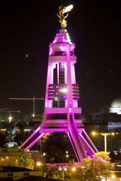
It was originally built in the centre of the city and rebuilt in the south surrounded by a park. When in the centre of the city, the statue used to rotate to face the sun but now simply faces towards the city.
Ashgabat Cable Car. On the south side of the city, this cable car ascends to a complex about half way to the top of the mountains. There is a restaurant. Because of the distance from the city, the views are not as interesting as you would think. The best views are down the road where it cuts across a 24km-long, 5m-wide walking path. There at dusk, we used Murad’s excellent binoculars to locate every monument and the hotel in the skyline of Ashgabat. They are all lit up with a changing kaleidoscope of colour.
Tree plantations cover the surrounding hillsides.
Turkmenbashi’s Health Pathway. It starts at a columned complex in the southwest of the city. It goes 8kms west over the top of a mountain with a large flag pole and 24kms east over the TV tower, climbs over another mountain with a dome, then the cable car base continuing to a point far to the east of the city. It is ironic that Turkmen don’t like to walk so most of it is little used.
TV and Radio broadcasting tower. Sitting half way up the side of the mountains to the west of the city, it is 211m high and sits 1,300m above the city. It is just north of the cable car. A stairway climbs up the side of the mountain.
State Center of Culture of Turkmenistan. Consisting of three large buildings each with a central dome and surrounded by a dome on each corner (lit by gold lights at night), the buildings hold the national library, a convention centre and an administration building.
Independence Monument. Built in 2001 to commemorate Turkmenistan’s independence on October 27, 1991, it is 118m high (27 + (19)91 = 118). The bottom is a traditional Turkmen yurt with 8 decorative pillars (“Eight Legs monument”). Then there is a column with a crescent and 5 stars on top (on the Turkmen flag and state emblem). It is lit by changing blue, pink, red and green lights at night. The whole complex sits on a square base surrounded by many fountains each with a cascading waterfall and 9 grand stone/gilt statues of heroes of the country and at least 8 poets.
Inexplicably, the holiday was moved one month ahead to September 27 in 2018.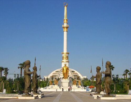
Constitution Monument. Built in 2012 on the 20th anniversary of the Turkmenistan constitution (one year after independence in 1991), it is 185m high, the second tallest structure in the country. The bottom is two levels of an 8-pointed star supporting a square column with the five carpet patterns of the five tribes of Turkmenistan. An elevator ascends to the balcony. Above the balcony is a three level column with a crescent and star on the top. At night the carpet patterns change colours independently and the entire column changes colour from blue to green, to yellow. It is all surrounded by a 100m wide plaza.
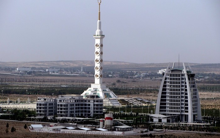
Ferris Wheel. This is the largest enclosed ferris wheel in the world. At night it is lit by a changing 8-cornered star.

Yyldyz Hotel. This 15-story hotel has one side round and the other flat giving it a half-egg shape. A restaurant at the top has panoramic views especially because it sits on top of a hill and is isolated from the rest of the city (only the wedding palace is near). Food and room prices are the most expensive in the city.
Wedding Palace. This consists of 3 large banquet halls for weddings plus offices where you officially complete the marriage process. The official name stands for “Palace of Happiness”.
Day 3
Parthian Fortresses of Nisa. About 15kms west of Ashgabat, Nisa was the first settlement of two brothers from a nomadic tribe who went on to found the Parthian Kingdom in the 3rd century BC . They soon moved the headquarters of the kingdom to N Iran as Nisa was too small. It occupies 14 hectares on the top of a hill. A 5-sided trapezoidal wall with 43 towers was constructed on a dirt bank make of dirt excavated from the interior. It was more of a small town, but used by 44 Parthian kings. Inside are the 17m-diameter Round Hall, 60m on a side Square Hall, Kings Hall and a labyrinth of narrow corridors.

The kingdom was weakened by invasions from nomads from the north, Romans from the west and eventually fell to the Persians in 224 AD. The ruins were completely covered in dirt when first discovered in 1888 until excavation exposed the mud brick walls. Restoration is ongoing but each rain causes more of the structure to melt away.
It is a World Heritage Site. 
Turkmenbashi Ruhy Mosque (Kipchak Mosque or Spiritual Mosque of Turkmenbashi). Built between 2002-4 this is the biggest mosque in Central Asia able to hold 10,000 worshippers. The outside is fantastic with 4 minarets, gold domes, large pools with fountains and a 17-step cascading waterfall surrounding 95% of the building. Inside the eight-pointed star shape building are 7 entrances and all the columns are white marble with grey marble insets – 22 support the balcony and 16 large ones support the huge dome – 55m high, 50m diameter, lined with 48 windows and decorated with trapezoidal geometrics. The base of the dome and walls have inspiration messages about Mohammed and Turkmenistan.
There was no one else there. It is not used much as it so far out of the city built in the town of Kipchak, the birth place of Turkmenbashi.


Turkmen Carpet Museum. This is a wonderful museum with 2000 carpets all with designs specific to the five traditional tribes of Turkmenistan. A lovely young woman guide gave us a complete run down on Turkmen carpets. Not only used as rugs, there are carpet saddle bags, camel and horse decorations, hand bags, a long woven cloth used to encircle yurts, sacred carpets that hang over the doors of tents, pillow cases and other uses. The earliest date to the 1700s and represent a wealth pf symbolism Turkmen carpets are “nomad” carpets usually made of wool and produced in traditional methods in people’s homes. Almost all have a red colour scheme and most colours are made from natural dyes that are colour fast.
Besides traditional designs, several were scenes of landscape and buildings not nearly as attractive as the pattern rugs.
There are three giant carpets: “Soul of Turkmenistan” – 7½m X 18m, made in WWII; “Five Headed” – 14 X 21½m, was the largest hand woven carpet in the world but has been surpassed by the carpet in the Abu Dabi mosque, weights 2,200kg; third giant carpet 11m X 16m.

We then left for the north of Turkmenistan.
GO TO Turkmenistan – North – Daşoguz, Lebap (Turkmenabat)
On the evening of October 29, we flew from Dasoguz back to Ashgabat, stayed in the same hotel in Ashgabat and then I left for Mary at 9am with a new guide.
Day 6 Drive to Mary
I was picked up from my hotel in Ashgabat at 9 and we left for Mary, 350kms and a 4 hour drive. We had to take a taxi to outside of Ashgabat to a village where we met a second driver (who could not enter the city).
Abiwert
About 120kms east of Ashgabat, this was an ancient city on the Silk Road active from the 9th to the 13th centuries. It covered 270 hectares and was totally destroyed by the Mongols in 1221 and never rebuilt. It is now almost entirely low melting mud-brick walls with a few buildings replastered in adobe. There was virtually nothing to see.
It is part of the tentative WHS Silk Roads Sites in Turkmenistan (01/03/2010), but will never make onto the WHS list.
Gonurdepe (Margush, meaning ‘lowland’, or in Greek – Margiana) 2hours from Mary it was the 5th center of civilization The Merv Oasis was an important centre for human settlement long before Achaemenian times. A remarkable Bronze Age civilization existed here. It has been gradually uncovered since the early 1970s. The Bronze Age sites are to be found at or beyond the northern edge of the present-day oasis, in land, which is now, desert. Climatic change and progressive desertification caused the abandonment of the area, with the result that the ruins of the Bronze Age settlements are well preserved beneath the desert soils. The Margiana sites seem to have had close ties with those at Bactria, in present-day northern Afghanistan. Sarianidi argues that the Bactria- Margiana complex was a major center of ancient civilisation, and has speculated that Margiana may even have been a birthplace of Zoroastrianism.
To see many wonderful artifacts from Margush, the Mary Museum has one room almost completely devoted to here. There is gold jewelry, several odd long stone rods (whose purpose is uncertain but probably ceremonial), and several marble cult columns, and the usual large number of pots and metal pieces.
It was in my itinerary to drive here on October 31, but it was 2 hours on a terrible road each way and little more than more melting mud-brick walls to see. We decided not to go and instead spend more time in Merv and Mary.
We drove to Bayramali, 30 km to the east of Mary, where the historical park Ancient Merv is located.
STATE HISTORICAL and CULTURAL PARK “ANCIENT MERV”
Merv was a major Iranian city in Central Asia, on the historical Silk Road, located near today’s Mary in Turkmenistan. Several cities have existed on this site, which is significant for the interchange of culture and politics at a site of major strategic value.
Human settlements on the site of Merv existed from the 3rd millennium BC until the 18th century AD. It changed hands repeatedly throughout its history, being successively ruled by the Achaemenid Empire, a variety of Alexandrian successor kingdoms, Arabs, Turks, and the Safavid Persians, as well as by many others who held it for shorter periods. During the 12th and 13th centuries it became one of the largest cities in the world, having a population of as many as 500,000. It was one of the most important capitals of Islam along with Baghdad, Cairo and Damascus.
In 1221 the city opened its gates to an invading Mongol horde; the resulting destruction of the city proved devastating. Historical accounts contend that the entire population (including refugees) of a million people were killed.
Though rebuilt after the Mongol destruction, the city never regained its full former prosperity. Between 1788 and 1789 the city was razed for the last time, and its population deported. By the 1800s the city was completely deserted.
UNESCO has listed the site of ancient Merv as a World Heritage Site in 1999.
HISTORY
Its prehistory dates to the 3rd millennium BC. Under the Achaemenid Empire (c. 550–330 BC), the first city of Merv was founded in the 6th century BC under Cyrus the Great (559–530 BC). In the Hellenistic era, Alexander the Great’s visit to Merv is merely legendary, but the city was named Alexandria after him for a time. After Alexander’s death in 323 BC, Merv became the capital of the Province of Margiana of the Seleucid, Greco-Bactrian (256-125 BC), Parthian, and Sassanid states. In 53 BC some 10,000 Roman prisoners of war from the Battle of Carrhae were deported to Merv.
Merv was a major city of Buddhist learning, with Buddhist monastery temples for many centuries until its Islamicization.
The Sassanids took Merv in 220 AD, starting a long unbroken direct Sassanian rule of almost four centuries. Zoroastrianism, Buddhists, Manichaeans, and Christians of the Church of the East all practiced their religion here.
Arabs ended Sassanid rule in 651. In 671, 50,000 Arab troops moved to Merv as a colony. Using the city as their base, the Arabs took over large parts of Central Asia and Merv became one of the first parts of the Persian-speaking world to become majority-Muslim. Arab immigration to the area was substantial. Throughout the Abbasid era (750-1258), Merv remained the capital and most important city of Khurasan. In the late 10th century, Merv was described as “delightful, fine, elegant, brilliant, extensive, and pleasant”. From 813 to 818, it was the capital of the Muslim world and for the next 400 years functioned as one of the great cities of Muslim scholarship in Islamic law, hadith, history, and literature. The city continued to have a substantial Christian community.
Turks. In 1037, the Seljuks, a clan of Oghuz Turks peacefully took over Merv. Seljuk domains grew to include the rest of Khurasan and Iran, and it subsequently became a favorite city of the Seljuk leadership. Alp Arslan (Sultan: 1063-1072) and his descendant Sultan Sanjar (died 1157) were both buried at Merv.
During this period Merv expanded to its greatest size—Arab and Persian geographers termed it “the mother of the world”, the “rendezvous of great and small”, the “chief city of Khurasan” and the capital of the eastern Islamic world. Written sources also attest to a large library and madrasa and many other major cultural institutions. Its market was “the best of the major cities of Iran and Khurasan”.
During the 12th century Merv was one of the largest cities in the world. By 1210 it may have had as many as 500,000 residents.
Mongols. In 1221 Merv opened its gates to Tolui, son of Genghis Khan, chief of the Mongols – “The Mongols ordered that, apart from four hundred artisans. .., the whole population, including the women and children, should be killed, and no one, whether woman or man, be spared. To each [Mongol soldier] was allotted the execution of three or four hundred Persians. So many had been killed by nightfall that the mountains became hillocks, and the plain was soaked with the blood of the mighty.” Some historians believe that over one million people died in the aftermath of the city’s capture, including hundreds of thousands of refugees from elsewhere, making it one of the most bloody captures of a city in world history.
Excavations revealed drastic rebuilding of the city’s fortifications in the aftermath, but the prosperity of the city had passed. The Mongol invasion spelt the eclipse of Merv and indeed of other major centres for more than a century. By 1380 Merv belonged to the empire of Timur (Tamerlane).
Final Destruction. Uzbeks and Persians occupied it at various times until 1785, when Shah Murad Beg, the Emir of Bokhara, captured the city and in 1788 razed the city to the ground, broke down the dams, and converted the district into a waste. The entire population of about 100,000 were deported to the Bukharan oasis and Samarkand region.
Nineteenth century. Russians occupied the oasis in 1884. By 1868 the Russians had taken most of Russian Central Asia except Turkmenistan. By 1888 the city was entirely abandoned.
REMAINS
Excavations began in the period 1885-1894. From 1992 to 2000, remarkable discoveries were made.
Merv consists of a few discrete walled cities very near to each other, each of which was constructed on uninhabited land by builders of different eras, used, and then abandoned and never rebuilt. Various other ancient buildings are scattered between and around these four cities (cistern, ice houses, large cemetery); all of the sites are preserved in the “Ancient Merv Archaeological Park” just north of the modern village of Baýramaly and thirty kilometers east of the large Soviet-built city of Mary. Four walled cities correspond to the chief periods of Merv’s importance:
Erk Gala (“the citadel fort”) is the oldest part dating from the 7th century BC and correspond to Achaemenid Merv, and is the smallest of the three at 20 hectares. It also served as the acropolis for the Hellenistic city and later the Arc of the Islamic city. It was an industrial suburb to the Abbasid/Seljuk city, Soltangala – by far the largest of the three. The 25m high dirt mounded walls are round with a diameter of about 500m. Gäwürgala. (“Fortress of the Zoroastrians”) was important from the early Hellenistic era, the Parthians, Sassanids and was the capital of the Muslim part of the Iranian world during Islam’s first two centuries. Its three defensive walls, one built atop the next form a square 2kms on a side enclosing 400 hectares. It contained a mongol Buddhist stupa, Zorastrian Fire Temple, a Christian church and a mosque. Gäwürgala persisted as a suburb of the larger Soltangala as the craftsmens’ quarters throughout the Islamic era.
Soltangala. Soltangala (“the sultan’s fortress”) is by far the largest of Merv’s cities. Abu Muslim, the leader of the Abbasid rebellion, quickly built walls and it became the core of medieval Merv with centuries of prosperity followed.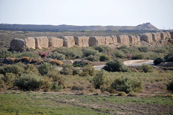 Merv’s largest and best-preserved Abbasid köşk is the Greater Gyzgala (“maiden’s fortress”), located just outside the Soltangala’s western wall; this structure consisted of 17 rooms surrounding a central courtyard. The nearby Lesser Gyzgala had extraordinarily thick walls with deep corrugations, as well as multiple interior stairways leading to second-story living quarters. These are in precarious states of preservation.
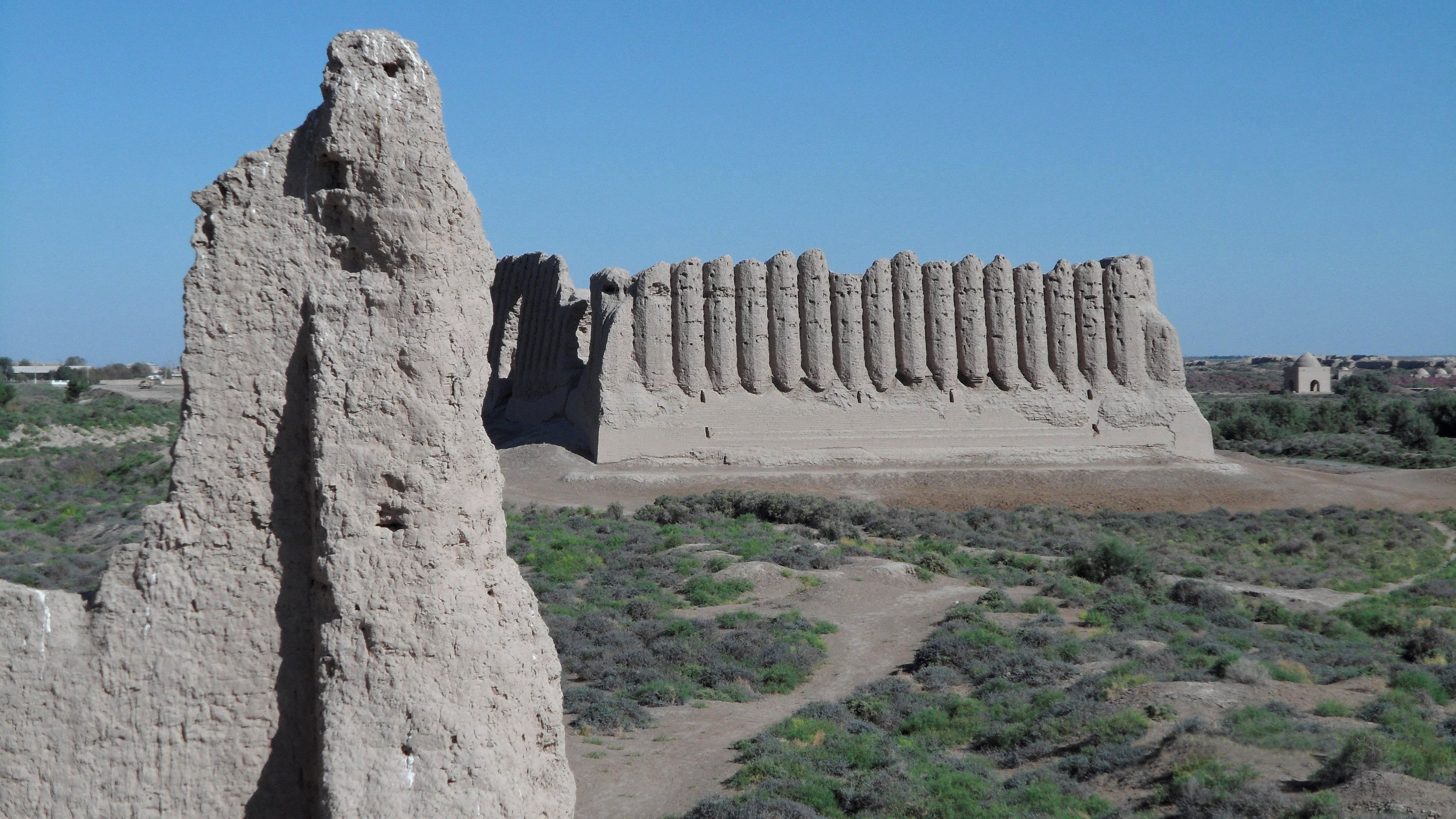
The most important of Soltangala’s surviving buildings are Seljuk constructions. In the 11th century CE, the nomadic Oghuz Turks under Togrul Beg arrived in 1037 and revitalized the city; his descendants, especially Sanjar, made it his residence, Merv found itself at the center of a large multicultural empire. Evidence of this prosperity is found throughout the Soltangala.
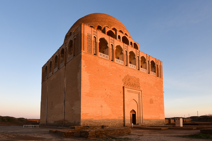
The best-preserved of all the structures in Merv is the 12th-century Mausoleum of Sultan Sanjar (1085-1157). It is the largest of Seljuk mausoleums and is also the first dated mosque-mausoleum complex, a form which was later to become common. It is square, 27 meters per side, with two entrances on opposite sides; a large 38m high central dome supported by an octagonal system of ribs and arches covers the interior. The walls are 5m thick. The dome’s exterior was turquoise, and its height made it quite imposing; it was said that approaching caravans could see the mausoleum while still a day’s march from the city. The mausoleum’s decoration was conservative, with interior stucco work and geometric brick decoration, now mainly lost, on the outside. With the exception of the 2002-4 Turkish “reconstructed” exterior decoration, the mausoleum is largely intact, and remains, just as is in the 12th century. Sanjar’s original marble tomb sits in the centre but his body had been moved to an unknown location before the Mongols arrived.
The dome produces an amazing echo lasting about 9 seconds.

MARY (pop 123,000)
Mary, formerly named Merv, Meru and Margiana, is a city on an oasis in the Karakum Desert in Turkmenistan, located on the Murgab River. It is the capital city of Mary Region. The ruins of the ancient city of Merv are located near the city.
History. The ancient city of Merv was an oasis city on the Silk Road. It was occupied by Imperial Russia in 1884, triggering the Panjdeh incident between Afghanistan, British forces, and the Imperial Russian Army. The modern settlement was founded later that year as a Russian military and administrative post. A force of the British Indian Army consisting of a machine gun detachment comprising 40 Punjabi troops and a British officer resisted the Bolsheviks near Merv in August 1918 in what was the first direct confrontation between British and Russian troops since the Crimean War.
Mary was developed by the Soviet Union as a center for cotton production through the use of extensive irrigation. In 1968, huge reserves of natural gas were discovered 20 kilometers west of the city.
After the collapse of the Soviet Union and the proclamation of independence of Turkmenistan, on 18 May 1992 Mary became the center of Mary Province.
In the 2000s, the city accomplished the construction of many streets and large residential facilities. Mass housing construction still continues. The city has built the new airport terminal, a new building for the Turkmen State Power Engineering Institute, theatre, library, historical museum, the Ruhiyet palace, the “Margush” hotel, a medical diagnostic centre, the “Ene Myahri” medical centre, the mosque Gurbanguly Haji, a stadium, an equestrian complex, an indoor swimming pool and a railway station.
Economy. Mary is Turkmenistan’s fourth-largest city and a large industrial centre for the natural gas and cotton industries, the nation’s two major export industries. It is a trade centre for cotton, cereals, hides and wool.
Mary is known for its Regional Museum. The city lies near the remains of the ancient city of Merv, which in corrupted form gives its name to the modern town.
Like all district capitals, Mary had a complex of marble clad government buildings. Here most are concentrated around the central roundabout – Congress building, library and theatre.
I stayed in the Merw Hotel, a 3 star hotel much less attractive than the Mary Hotel but with better wi-fi.
Mary History Museum. 1st floor: many photos of the president doing everything from playing tennis, riding horses, visiting places in the country and some of his 100 books he has personally written. As it turns out, he is a world authority on everything. Then natural history, modern art, all Turkmenistan artists (enjoyed the drawings of Chingiz Aitmatov),, ethnography (carpets, jewelry, embroidery, weaving with several looms). 2nd floor: large section on Margush with many more artifacts from here than Merv.
Mary Mosque. Another grand mosque full of marble columns. There are two rows, each of 24 nice stained glass. Another highlight is the large tiled panels.
Rukhiyet Palace. This is the Congress Building, another over the top marble collonaded building with a brass dome. It is used only when the president is in town and is not open to the public.
There is a similar Ruhkiyet Palace in Ashgabat. My guide and driver (from Mary) thought it was also called the Türkmenbaşı Palace.
Pokrovskaya Church. This redbrick Russian Orthodox church was founded in 1900. A slice of Russian architectural heritage, inside, it has light blue walls with dark blue/white geometrics. Every spare piece of lower wall is covered by framed icons and other religious works. The church is surrounded by pleasant parkland.

NOMAD MANIA Turkmenistan – South – Ashgabat, Ahal, Mary
World Heritage Sites
Parthian Fortresses of Nisa
State Historical and Cultural Park “Ancient Merv”
Tentative WHS
Badhyz State Nature Reserve (16/03/2009)
Silk Roads Sites in Turkmenistan (01/03/2010)
Sights:
Köw Ata Underground Lake
Borders:
Afghanistan-Turkmenistan
Iran-Turkmenistan
XL:
Serhetabad/Gushgy
Turkmenistan Sarakhs area
Religious Temples:
Gokdepe: Saparmurat Hajji Mosque
Kipchak Mosque
World of Nature: Köpetdag Nature Reserve
Waterfalls: Bolshoi Nokhur waterfall
Cities of Asia and Oceania:
ASHGABAT World Capital, World City and Popular Town
Airports: Ashgabat (ASB)
Railway, Metro, Funiculars, Cable Cars: Ashgabat Cable Car, Ashgabat Monorail
Museums:
Ashgabat National Museum of History
Museum of Fine Arts
The Main Museum of Turkmenistan
Turkmen Carpet Museum
Turkmenbashi Museum
Religious Temples:
Ertuğrul Gazi Mosque, Ashgabat
Turkmenbashi Ruhy Mosque, Ashgabat
Modern Architecture Buildings:
Arch of Neutrality (Monument)
Independence Monument
Yyldyz Hotel
Markets: Teke Bazaar
Monuments:
Constitution Monument
Halk Hakydasy Memorial Complex
Zoos: Ashgabat Zoo
Botanical Gardens: Botanical Garden
Planetariums: Ashgabat Planetarium
Theme Parks: World of Turkmenbashi Tales
MARY/BAYRAMALY
Airports: Mary (MYP)
Museums: Mary History Museum
Castles, Palaces, Forts:
Rukhiyet Palace
Türkmenbaşı Palace
Religious Temples: Pokrovskaya Church, Mary
