
Turkmenistan – North – Daşoguz, Lebap (Turkmenabat) October 28-30, 2019
After seeing the last sights in Ashgabat (Nisa, Carpet Museum, Turkmenbashi Ruhy Mosque), we had lunch in the big shopping center and started the drive to the Darvaza gas fire crater. I was joined by a young woman from Sweden, a book critic for a major Swedish newspaper and on the Nobel Prize for Literature selection committee.
Yerbent (pop 3000)
One of the largest towns in the desert, it is in Ahal Province. It gets its water by pipeline from Ashgabat and collects rainwater. It has all the basic services.
After the Soviets took over in 1924, this town revolted against Russian control and in 1931, 11 Russians were killed by the locals. The Russians finally gained control by force. Hundreds were eventually killed in one raid against the Yamut tribe.
The economy is based on animal husbandry – cattle, sheep, camels, goats. Little is grown. In the old days, opium production was a significant industry.
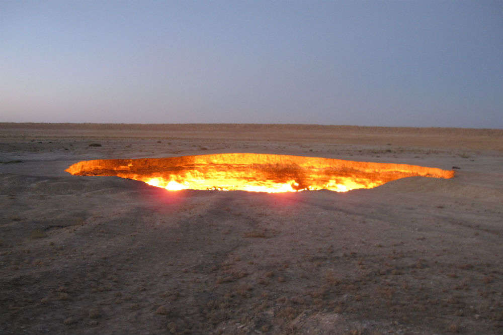
DARVAZA GAS FIRE CRATER
Originally this area was a huge shallow inland sea that extended to Kazakhstan, Tajikistan and Iran and eventually became the Caspian and Aral Sea. It has large gas reserves. The Russians developed a sulphur mine in the 1930s and built a road to the area in the 1950s. Villages developed into the town of Darvaza. In the 1970s the sulfur was being depleted and they started to drill for gas, sometimes hitting natural underground caverns. The roof of one of these caverns collapsed and formed a crater. Methane was being naturally extruded killing local wildlife. The Russians wanted to burn off the methane so in the early 70s, they rolled a tire on fire into the crater as they thought there was not much gas. There was a great explosion and the fire started, originally there was a much larger fire visible from the main road 7-8kms away. In 2012, National Geographic sent a team to explore the crater and the fire.
The Gas Crater is about 7-8kms off the main road on a sandy track. It is a little bigger at 69m across at its widest and about 25m deep. A 10m vertical wall abuts a sloping rock debris slope that surrounds a small flat area at the bottom with the most fire. Fire also is most pronounced at the top of the sloping rock with random patches throughout. It is most dramatic at night – flames can’t be seen from a distance but only when walking around the perimeter rope fence. There is just an eerie glow emanating from the big hole in the ground.
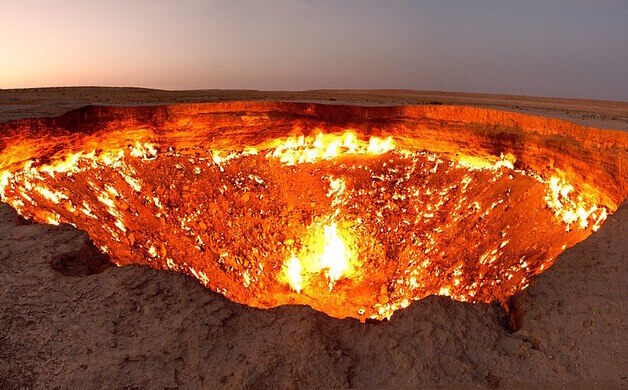
The highest temperature recorded was 650°C, special bacteria were discovered and a lot of garbage. The fire has burned ever since starting in the 70s. It is not a commercially viable gas source. It has become Turkmenistan’s greatest tourist attraction earning the label “Gates of Hell”. It is not known if it will ever burn out but our guide says it has not decreased over the last 6 years.
There are about 20 yurts belonging to several companies, one with 10 yurts and most smaller, some just one and two yurt operations. There are several toilets but all were locked. We stayed in one yurt operated by 2 guys who stay here most of the time and also herd sheep. Tourists come from Ashgabat and Daşoguz making prior arrangements to stay in the yurts or have their motorhomes.
Sometimes in the summer, it is very crowded, especially during the Mongol Car Rally that starts from various places in Europe and follows branches of the Silk Road to Mongolia. Then it is crowded and noisy.
There are two other craters along the road also produced by gas drills. We stopped at both.
Crater #1 (Water Crater). An almost perfect circle about 50m across, it has vertical walls about 35m down to a fairly deep lake full of greenish water that rarely if ever freezes. The walls have obvious sedimentary layering. An island of plastic bottles floats on the surface and moves around with air currents.
Crater #2 (Mud Crater). About 10 km further down the highway and about halfway to the main fire crater, this is about the same size but has no water and constant small fire, even when large rains fill the bottom with water.
The highway to Daroguz was a mess of potholes and rough pavement for the first 100kms, then ok for a while. After the turnoff to Dasoguz, the potholes returned. Another oddity of Turkmen roads is that you often have to completely change sides of the highway.
KUNYA-URGENCH (pop 30,000) World Heritage Site (2005)
Old Gurgānj also known as Kunya-Urgench, Old Urgench or Urganj, is in north Turkmenistan, just south of its border with Uzbekistan. It is the site of the ancient town of Ürgenç (Urgench), which contains the ruins of the capital of Khwarazm, a part of the Achaemenid Empire. Its inhabitants deserted the town in the 1700s to develop a new settlement, and Kunya-Urgench has remained undisturbed ever since. In 2005, the ruins of Old Urgench were inscribed on the UNESCO List of World Heritage Sites.
On the south side of the Amu-Darya River, Old Ürgenç was situated on one of the most important medieval paths: the Silk Road, the crossroad of Western and Eastern civilizations. It is one of the most important archaeological sites in Turkmenistan, lying within a vast zone of protected landscape and containing several well-preserved monuments, dating from the 11th to the 16th centuries. They comprise mosques, the gates of a caravanserai, fortresses, mausoleums and a minaret, and the influence of their architectural style and craftsmanship reached Iran, Afghanistan and the later architecture of the Mogul Empire of 16th-century India.
History. The exact dates when Kunya-Urgench was founded remain uncertain, but archaeological finds at the Kyrkmolla Hill (one of the main fortresses at the site) reveal that the town already had a strong structure in the 5th and 4th centuries BC. Some of the earliest records show that Khwarezm was conquered by the Arabs in 712, and Kunya-Urgench was given the Arabic name “Gurgandj”. The city rose to prominence between the 10th and 14th centuries as the Khwarezmian capital, and as an important trading centre, competing in fame and population with many other Central Asian cities, such as Bukhara. It had become highly prosperous due to its strategic location on the main trade routes from the south to the north, and the west to the east, vastly contributing to the development of science and culture in Central Asia.
In 1220 both the town and dam were destroyed by the Mongols and the surrounding area became a marsh. In 1221, Genghis Khan destroyed the city in the Mongol invasion of Central Asia, in what is considered to be one of the bloodiest massacres in human history. Despite the devastating effects of the invasion, the city was revived and it regained its previous status. It was described by the 14th-century Berber traveller Ibn Battuta as “the largest, greatest, most beautiful and most important city of the Turks. It has fine bazaars and broad streets, a great number of buildings and an abundance of commodities”.
In 1373, Timur attacked Khwarezm, and its ruler Yusef Sufi of the Sufi Dynasty surrendered to Timur. In 1379, Yusef Sufi rebelled against Timur, who sacked Urgench, and Yusef Sufi was killed. In 1388, the Sufi dynasty of Urgench again revolted against Timur; this time Timur razed Urgench to the ground and massacred its population, destroyed the city’s irrigation system, and had barely planted over the ground where the city had once stood, leaving only one mosque standing. This, coupled with the sudden change of the Amu-Darya River’s course, constituted the beginning of Kunya-Urgench’s decline until the 16th century when it was replaced as a regional capital by Khiva and was ultimately abandoned.
The area was later inhabited by the Turkmen people from the early 19th century, but they mostly developed outside the old town, utilizing the latter as a graveyard. However, this use has now stopped, and efforts have been made to remove the decaying gravestones that can be encountered at the site.
Kunya Urgench has been, for a long period, a prolific school of construction masters. The knowledge and skills of this school have spread, throughout the centuries, amongst the Muslim world, and can be recognized in the structures and decorations of many buildings from the Timur period, both within Turkmenistan and in regions such as Uzbekistan, Afghanistan, Transcaucasia, Turkey, Iran, Pakistan and India. For example, a multitude of buildings in Samarkand were erected by builders and architects employed by Kunya Urgench in the 14th century.
The ingenuity and skill of the local craftsmen and architects can be seen in the exceptional construction details, such as structure, form or ornamentation, which have been perfected throughout time. Furthermore, traditional building techniques have survived to this day: for example, the kilns at Kunya Urgench are still used throughout the region for the production of bricks utilized in the reconstruction of historic buildings.
The new town of Urgench was developed to the southeast, in present-day Uzbekistan.
ARCHAEOLOGICAL REMAINS. The urban layout of Kunya Urgench has been lost and only certain monuments remain standing to this day. These are authentic and rich examples of fine architecture and building traditions that have existed for centuries. The level of conservation varies amongst the buildings, and the most substantial restoration work has been carried out in the past thirty years, during the Soviet era, using traditional methods and materials.
Kutlug-Timur Minaret. The Kutlug Timur minaret is perhaps the most striking structure here. It dates to the 11th and 12th centuries, and measures 60 meters in height, making it the highest monument in the park. Its diameter is 12 meters at its base and 2 at the top.
Based on its decorative brickwork, including Kufic inscriptions, the minaret is thought to be an earlier construction, only restored by Kutlug-Timur around 1330.
Turabek-Khanum Mausoleum.
Named after Turabek-Khanum, the wife of Kutlug-Timur (who ruled between 1321 and 1336), this structure is located in the northern part of ancient Gurgench. It is remarkable for its elegant design and stunning tile decoration, and it is a highly sophisticated work of architecture, both in its conceptualization of spaces and in its engineering. Both are fully utilized in a conscious way to achieve a visual, aesthetic and spiritual effect.
The original building was composed of two chambers: a large domed hall and a smaller one behind it. The large chamber is twelve-sided on the exterior and hexagonal on the interior, being preceded by an entrance portal and a vestibule.

One of the most impressive architectural features of the mausoleum is the circular dome covering the main hall, whose surface is covered in colourful mosaic which forms intricate ornamental patterns consisting of flowers and stars, creating a visual view of constellations and the cosmos.
Tekesh Mausoleum. This structure is the presumed Tomb of Sultan Ala al-din Tekesh, the founder of the Khwarezm Empire and its ruler between 1172-1200.
The building is made of bricks and consists of a square hall with walls which are 11,45 meters high, a massive round drum and a conical roof with an inner dome hidden under it. The dome is connected to the square walls it rests upon by an octagonal belt. The structure between the dome and the octagon is decorated with 16 shallow niches.
The external conical roof is built of horizontal layers using the technique of a false vault. From the inside, it is strengthened with 12 buttresses standing upon the internal dome. Although this might seem like a risky construction technique, the roof is not in bad condition: only the top is destroyed, and the blue majolica decoration slightly damaged.
One of the special features of the building’s architecture is its façade. It presents a high portal niche with the main archway, which has now lost its original form. The lancet arch of the portal is filled by a complicated system of stalactite-like forms, which is a decorative motif made of terracotta and fixed on wooden sticks within the brickwork.
Research concerning this structure has given rise to speculations that the Mausoleum of Tekesh might have stood at the centre of some large construction that consisted of a multitude of buildings. Thus, certain scholars would argue that the building served a different purpose from that of a mausoleum, such as, for example, a House of Government or a Palace of the Great Khwarzm-shahs.
Kyrkmolla. Kyrkmolla is a 12-meter-high (39 ft) mound which used to constitute a fortress. It is located in the north-eastern outskirts of Gurgench. It is particularly significant as the earliest ceramics discovered at the site, dating back to the 5th century BC, were located here. It is protected by a thick mud-brick wall which dates back to the 10th to 14th centuries and has been partially rebuilt after archaeological excavations.
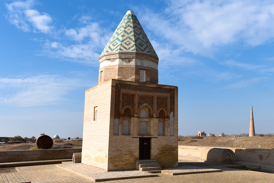
Il Arslan Mausoleum (Mausoleum of Kho-Rezmshah II)
Il Arslan is a magnificent piece of architecture. Arslan ruled from 1156 to 1172 and the mausoleum dates to the 12th century and is the oldest standing monument in Gurgench.
The building has a cuboidal structure of baked brick similar to the earliest existing Islamic mausoleum in Central Asia, the early 10th-century mausoleum of the Samanids in Bukhara, but instead of a hemispherical dome it has a faceted conical roof. The structure is decorated with a motif carved in relief into brick panels, a frieze containing an aphorism written in beautiful script, and carved vegetal motifs displaying variations of an arabesque pattern. The decorative scheme of the dome presents a tiling technique executed in turquoise glazed brick tiles, forming a geometric pattern.
Ibn Khajib Complex. Dedicated to Ibn Khajib, one of Najm-ad-Din al-Kubra’s talented disciples, it is in the western part of ancient Urgench and it consists of a complex of monuments, all constructed in different periods, from the 14th to the 19th centuries.
Ak-Kala. Ak-Kala is a fortress located southwest of the ruins of medieval Urgench. Its 6-8m high, sun-dried mud-brick walls are 2m at the top and are over a kilometre long. The corners had semi-circular towers.
Khorezm-Bag. This quadrangular fortress, erected by Khan Muhammed Emin, measuring 400 by 500 meters, was built in the mid-19th century in the south-western outskirts of Kunya-Urgench. It is surrounded by a high defensive wall which has been severely eroded by the passing of time.
Najm-ad-Din al-Kubra Mausoleum, Sultan Ali Mausoleum and Piryar Vali Mausoleum Complex.
This complex is situated in the centre of the new town of Kunya-Urgench, within a Muslim cemetery. The Najm-ad-Din al-Kubra Mausoleum was erected in the first half of the 14th century and derives its name from the philosopher, painter, physician, chess master and general Ahmed Ibn Omar Najm-Ad-Din al-Kubra, the founder of the Kubrawiya Sufi order. This is one of the structures rebuilt during the Khorezm era of prosperity, and also after the Mongol invasion.

The Mausoleum of Sultan Ali, who ruled in the 16th century, is located across. It is a hexagonal monument, with a dome measuring 9.5 meters in diameter.
The Mausoleum of Piryar Vali, a contemporary of Najm-Ad-Din al-Kubra, is located to the west of the latter’s mausoleum and was built in the 13th and 14th centuries. It is 6.5 meters high and measures 7.5 meters in length.
