
Turkmenistan – West – Balkan (Balkanabat, Turkmenbashi) October 27, 2019
When I arranged my tour with Murad, I sent the Nomad Mania lists of the three regions of Turkmenistan saying that I would like to visit every region and see “what was easy to see”. That is how he arranged for me to visit the West/Balkan region of the country. But the details of that visit were very vague – and ended up being much more arduous than I thought they would be.
Train Ashgabat to Balkanabat. 19:30 – O5:30, ie. 10 hours in a sleeper car.
Local driver with a 4WD met us at the train station.
150km and 2-3 hours drive on dirt, wash board road
4.5kms on high clearance 4WD road to the viewpoints.
Yangykala Canyon. Getting to Yangykala Canyon takes a lot of effort and time. From Balkanabat, it is 150kms and 2-3 hours each way. Starting in the dark for 1½ hours, drive through a remote desert and after the first village, no villages, farms or people but one water pumping station. The sand dunes, where they existed, had blown over the road. Descend off the plateau into a wide plain bounded to the west by high white limestone cliffs, spectacularly eroded into narrow ridges and gullies. On top is a tan rock “cap rock and at the base the white turns to pink. The road varies from single tract dirt with washboard to a wider road.

Then climb up onto the top of the cliffs on a high clearance 4WD road for 4½kms. The cliffs form very narrow bits and have viewpoints:
Scenic Stop #1. At a narrow area between the cliffs, there is a great overlook down to the eroded cliffs with the bottom pink formations layered with white. A stream meanders at the bottom.
Scenic Stop #2. Look down to the same area but from a different angle to see the fine pink/white layering of the eroded gullies.
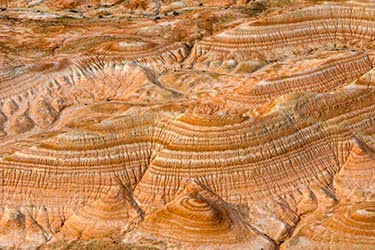
Scenic Stop #3. The rough road terminates at the end of a peninsula of cliffs. Again the erosional features are spectacular as the cliffs are much higher here.

We then drove back off the cliff top and stopped in a wind-free area and had breakfast over a fire – coffee, pumpkin pie, meat, tomatoes, baklava.
It was then the long return drive to Balkanabat. I’m not entirely sure it was worth all the effort. I have seen similar eroded limestone in other parts of the world, most notably at San Pedro de Atacama in Chile. But these were quite beautiful and unique.
BALKANABAT
Balkanabat, like all Turkmenistan major cities and capitals of each province, has many modern major government buildings, all clad in white marble: convention centre, flag pole square, central library, hippodrome (horse racing track), sports stadium, theatre, matrimonial centre, medical centre.
Monument to the Pioneer. A large white stone Soviet monument has a camel being led by a local through a sandstorm
Turkmenbashi Monument. One of many statues of Niyazov in Turkmenistan (every provincial district has one making about 60, then add the 10 or so in Ashgabat, there are about 70 in the country), the gold figure stands on a marble column on a marble base.
We changed cars from the driver to Yangykala Canyon to another driver and came back to Ashgabat converting the 10-hour train ride into a 4-hour drive.
Serdar (pop 50,000)
This city was on the way back to Ashgabat. Mainly Turkmen, it is near the northwest end of the line of oases on the north slope of the Kopet Dag that extends southeast to Ashkhabad. It has nothing special to see.
Back in Ashgabat, we ate at a traditional Turkmen restaurant whose specialty was plov, rice with raisins, apricots and meat. I also had a surprisingly good Caesar salad.
Of note, businesses that face a main street may have a sign with the name but not that it is a restaurant. Their existence is only known if brought here by friends or word of mouth.
GO TO Turkmenistan – South – Ashgabat, Ahal, Mary
