
Day 4 Thur June 22
I left Beijing from the Beijing South train station for the 30-minute high-speed rail trip to Tianjin. But there were no tickets until 17:30 and I had all day to kill. I could never have imagined that despite trains every 15 minutes to Tianjen, they would be sold out all day. I had great help from a Chinese woman with perfect English who works in water management and has lived in Denmark for 11 years.
So I decided to go to Zhoukoudian, the Peking Man WHS, about 48km from Beijing, all by metro.
I arrived back at Beijing South Train Station at 15:30, had a poor double Whopper and caught the high-speed train to Tianjin West train station. Walked 2.5 km to a hotel that didn’t allow foreigners and then took a long time to find one that did.
ON Orange Hotel 571 RMB.
Day 5 Fri June 23
I was up early and actually found something to eat in the buffet breakfast. I wanted to rent a bicycle to see the sites in Tianjin City, but this type required a WeChat payment. I then spent almost 2 hours with Anna to try to solve my WeChat registration without success. I got a taxi to Tianjin West Railway Station, and waited 2 hours for the next train to Shenyang, 3’30 minutes by hi-speed rail 248 RMB in second class.
CHINA – TIANJIN MUNICIPALITY
TIANJIN (13,866,000) is a coastal metropolis that borders Hebei Province and Beijing Municipality, bounded to the east by the Bohai Gulf portion of the Yellow Sea.It is one of the nine national central cities in Mainland China, It is the 11th-most populous city proper. In terms of urban population in the world, Tianjin is the seventh largest city in China.
The walled city of Tianjin was built in 1404. As a treaty port since 1860, Tianjin has been a major seaport and gateway to Beijing. Under the Qing dynasty and the Republic of China, numerous European-style buildings and mansions were constructed in concessions, many of which are well-preserved today. After the founding of the People’s Republic of China, Tianjin suffered a depression due to the policy of the central government and 1976 Tangshan earthquake but recovered in the 1990s. Tianjin is classified as the largest type of port city, a large port Megacity, due to its large urban population and port traffic volume.
Nowadays, Tianjin is a dual-core city, with its main urban area (including the old city) located along the Hai River, which connects to the Yellow and Yangtze Rivers via the Grand Canal; and Binhai, an adjacent New Area urban core located east of the old city, on the coast of the Bohai Gulf. As of the end of 2010, around 285 Fortune 500 companies have set up bases in Binhai. Since 2010, Tianjin’s Yujiapu Financial District has become known as China’s Manhattan.
Tianjin Station West is a great new railway station with over 20 tracks and many food places.
Tianjin Eye. In the NM Bizzarium series, this is a 120m high Ferris wheel that sits on a bridge spanning the river. It is lit up at night.
I got a taxi to Tianjin West Railway Station, and waited 2 hours for the next train to Shenyang, 3’30 minutes, 660km, by hi-speed rail for 248 RMB in second class. The trains are wonderful – quiet, fast with short stops.
=============================================================
CHINA – HEBEI NORTH (Tangshan, Chengde, Zhangjiakou)
I transited this region as I had been there before and couldn’t see getting transportation to Chengde. I then returned on July 29th on my quest to see as many WHS in China as possible and saw Chengde.
=============================================================
CHINA – LIAONING NORTHWEST (Shenyang, Jinzhou, Panjin, Tieling)
SHENYANG (pop 9,100,000 2020) is the major city of Liaoning Province. Located in north-central Liaoning, it is also the largest city in Northeast China by urban population.
Shenyang is also the central city of one of the major megalopolises in China, the Greater Shenyang Metropolitan Area, which has a total population of over 23 million.
Shenyang has passed through the control of many states and peoples in history. In the 14th century, Shenyang came under the control of the Ming dynasty. The city served as an important Chinese military stronghold during the Ming period. The Manchu people conquered Shenyang from the Ming in the 17th century and briefly used it as the capital of Qing Dynasty China. In 1905, the Battle of Mukden took place south of Shenyang during the Russo-Japanese War. Japan’s subsequent victory allowed Tokyo to annex the region west of the old city and to increase Japanese influence on Shenyang; in September 1931 the Mukden Incident led the Japanese to further invade and occupy the rest of Northeast China, forming the puppet state of Manchukuo. After the Japanese surrender in 1945, Shenyang remained a Kuomintang stronghold, but the Communists captured it in 1948 after the Liaoshen Campaign.
Along with its nearby cities, Shenyang is an important industrial center in China and serves as the transportation and commercial hub of China’s northeast—particularly involved in links with Japan, Russia and Korea. Growing industries include software, automotive, and electronics.
Airports: Shenyang (SHE)
ON Best Western Express Shenyang North Railway Station. CA$55. Very nice with a good Western-style breakfast.
Day 6 Sat June 24
Anna and I arranged to again try WeChat registration at 05:30. WeChat is impossible. We changed my number to my Skype number and were able to register (need a WeChat friend to verify you) but you need to add a bank card to finish the verification and WeChat would not accept any of the three cards for security reasons. So even though I got close, I still don’t have WeChat.
After, I had a shower, had a good breakfast with Western choices, and rented an electric scooter (one type accepted only WeChat but the Hello brand accepted Alipay which I was able to navigate even though it has changed to all Mandarin) to try to see some of Shenyang. I ended up seeing all the NM sites easily accessible in about 1 1/2 hours. I was then able to cancel the bike rental (20 RMB).
Forum 66. In the NM Architectural Delights series, is a twin-tower complex that consists of two super tall skyscrapers; Tower 1 is 384 m (1,260 ft) with 76 floors and Tower 2 is 351 m (1,152 ft) with 68 floors. Tower 1 was completed in 2015 whilst the construction of Tower 2 has been suspended as of 2023. There is a high-end shopping center, hotel and serviced apartments. Forum 66 is the Hong Kong property developer’s second landmark development in Shenyang.

Banruo Temple. A small Buddhist temple with 4 gold Buddhas and the usual decorative elements.
Ci’en Temple. Another Buddhist temple but under renovation. I was able to enter the grounds and peer through some windows.
Changan Temple. A large Buddhist temple complex but all gates were closed.
Marshal Zhang’s Mansion. In the NM Architectural Delights series, this was the home, office and military command headquarters of Zhang Xueliang (1901-2001), known as Young Marshal, who helped turn the course of Chinese history in 1936 and then spent the next 55 years under house arrest (41 years in Taiwan). It is a residential complex with both Chinese and Western architectural styles. The place is well-preserved and the artifacts are in good condition.
Son of the powerful warlord and Old Marshal Zhang Zuolin (1875-1928), who effectively ruled northeast China in the early 1900s, the young marshal showed his patriotism, military talents and heavy hand after his father was assassinated by the Japanese army.
In 1936, Zhang kidnapped his commander-in-chief and head of the Kuomintang Chiang Kai-shek (1887-1975) at a hot-spring resort near Xi’an, Shaanxi Province, and forced him to form a united front with the Communist Party to fight against the Japanese aggression spreading across the country. Chiang agreed, but when he had an opportunity, he seized Zhang. This was a pivotal moment in modern Chinese history, and the “Xi’an Incident” Zhang engineered landed him in prison for more than half a century. The young marshal never returned to his Shenyang mansion, a place where he spent his youth.
His statue stands high on the front plaza of the main entrance. There are three courtyards, a house and an office area. It’s said the old marshal had a strange regulation that everyone must stride over the threshold; those who stepped on it would be immediately executed.
When the family grew, two new buildings were built – the big and small greenhouse, owning their names to the green bricks on the exterior walls.
The big one, built in 1922, is designed in European palace style with carved beams, painted rafters, and marble pillars. Each room was intended as a suite, fully furnished and decorated. This was where Zhang had meetings and made important military decisions, as well as killing two high-ranking officials, Chang Yinhuai and Yang Yuting, in 1929. The two planned a coup d’état to wrestle power from the young marshal when he succeeded his father as the leader of the Northeast Army just after the Old Marshal’s assassination.
The central rockery that faces the main door was specially designed by the Old Marshal, which also served as a protective blockhouse.
The residence of Edith Chao (1912-2000) is in the mansion’s eastern section. Chao lived there from 1928-30 as the Young Marshal’s girlfriend, even though he was married to Yu Fengzhi at the time. The free-standing house covers an area of 547 square meters, featuring both traditional Chinese mural painting and Western-styled carvings on the posts and beams. Chao accompanied Zhang throughout his 50 years of house arrest, and the couple’s love story was seen as one of the greatest in the history of modern China.
The meeting hall, ballroom, dining room, piano room, study, and office were all refashioned to their original appearance. There is a large exhibit of headrests. Free
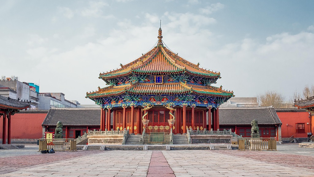
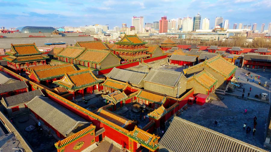
Mukden Palace. This is one of two existing large palace complexes in China with an area of more than 60,000 square meters, has 114 ancient buildings, and is a well-preserved ancient site carrying rich history and cultural content.
The seat of supreme power for over five centuries (1416-1911), the Forbidden City in Beijing, and the Imperial Palace of the Qing Dynasty in Shenyang consist of 114 buildings constructed between 1625–26 and 1783. It contains an important library and testifies to the foundation of the last dynasty that ruled China before it expanded its power to the centre of the country and moved the capital to Beijing. This palace then became auxiliary to the Imperial Palace in Beijing.
It follows the traditions of palace construction in China but retains typical features of traditional folk residences of the Manchu people, and has integrated the architectural arts of Han, Manchu, and Mongolian ethnic cultures. The buildings were laid out according to the “eight-banner” system, a distinct social organization system in Manchu society, an arrangement that is unique among palace buildings.
The best-known building is the Phoenix Tower, built between 1627 and 1635 in the Qing Dynasty. The three-story building with a gable and hip roof was the tallest structure in the ancient capital of Shengjing. The second and third floors were closed. Free
I transited this area as I had been there before. Dalian is a long way out of the way. The main site of the WHS is in Jilan East.
CHINA – LIAONING SOUTHEAST (Dalian, Liaoyang, Fushun, Benxi)
====================================================================
CHINA – JILIN EAST (Jilin, Yanbian, Tonghua)
I arrived at Tonghua at 15:30 (3’15” from Sengyang). The van stopped on the west outskirts of Tonghua, but I continued onto the downtown area, which was a mistake as the road to Ji’an leaves from the west side of the city. The stop was not at a bus station but on the road. One of the passengers had said that there was a bus to Ji’an at 15:30, but I had probably already missed that. A taxi offered to take me the 108 km to Ji’an for 200 RMB (about US$28) so that is what I did. The bus is 20¥.
JI’AN (pop 230,000) is a county-level city in the southwestern part of Jilin province. It is separated from Manpo, Chagang Province, North Korea by the Yalu River; it has an international border running 203.5 km (126.4 mi).
In 3 CE, the second ruler of Goguryeo, King Yuri, moved the state’s capital to Gungnae (modern Ji’an) and established the mountain fortress Hwando nearby to defend it. Hwando was sacked by the Wei State in 244 CE during the Goguryeo–Wei War. In 342 CE, Hwando was destroyed and thousands of people were captured by the Murong Xianbei, after which Goguryeo focussed on expanding south and east. In 427 CE, the eleventh ruler of Goguryeo, King Jangsu, moved the capital to Pyongyang, which saw Gungnae relegated to subsidiary capital status.
The Capital Cities and Tombs of the Ancient Koguryo Kingdom, located in Ji’an and Huanren Manchu Autonomous County, Liaoning, have been listed as part of a UNESCO World Heritage Site. Ji’an is also dubbed as a “Little Jiangnan” of Jilin due to its scenery.
Getting there. 6-seat van bus Shenyang Bus terminal (about a block from the train station) to Tonghua 3′. Taxi 200 RMB to the centre of Ji’an town. The hotel (a business hotel on the main street) did not take foreign guests (it took a long time to find that out – she kept saying “The computer doesn’t register”). Then the Xiangzhou Garden Hotel was in the wrong place on Google Maps – walk along the river through the large plaza with the giant guitar.
I ate at a Chinese restaurant for the first time picking a dish from the photos. It was breaded chicken with a few vegetables (too many fried hard red peppers), white rice and pickled something. The chicken had many bones and pieces of gristle but was quite tasty.
ON Xiangzhou Garden Hotel. Very nice but check-in was laborious – no English and not critical thinkers. This was the first place that asked for my visa. 371¥ with BF
Day 7 Sun June 25
I arranged with the hotel to order a taxi. He arrived punctually on time at 08:35, I briefly explained what I wanted to see and there was no problem. He initially wanted 300¥, but I see things very fast and easily bargained down to 200¥. He was very good and efficient and waited for me in the parking lots of the three sites. He ended up being happy with the arrangement.
CAPITAL CITIES and TOMBS of the ANCIENT KOGURYO KINGDOM. WHS. The site includes archaeological remains of three cities and 40 tombs: Wunu Mountain City, Guonei City, and Wandu Mountain City. 14 tombs are imperial, 26 of nobles. All belong to the Koguryo culture, named after the dynasty that ruled over parts of northern China and the northern half of the Korean Peninsula from 277 BC to AD 668. Wunu Mountain City is only partly excavated. Guonei City, within the modern city of Ji’an, played the role of a ‘supporting capital’ after the main Koguryo capital moved to Pyongyang. In total, there are over 10,000 tombs dating from the Koguryo era.
Ji’an’s ancient Koguryo sites are numerous: 1, 2, and 3 as a single ticket of 70¥ or 30¥ each.
1. Wandu Mountain Fortress. One of the capitals of the Koguryo Kingdom contains many vestiges, including a large palace, 37 tombs and 6,947 m in circumference. At the base of the mountain with no climbing to get to, it is heavily restored with a large walled city climbing around steep mountains.
Climb the stairs to the left to pass through the massive city walls, 8.7-11 m wide and 6.8m high. Pass the lotus pond (35x37m with originally a 1.8m high wall), viewpoints, the lookout tower (6.7×4.5 m x 4.5m high) for the border guards and climb up to the vestiges of the palace (a series of dirt terraces with on stones) and finally reach the flagpole.
Below and to the right is the cemetery of the noblemen, a collection of dozens of piled stone tombs and earth mound tombs. Some of the tombs show great ingenuity in their elaborate ceilings, designed to roof wide spaces without columns and carry the heavy load of a stone or earth tumulus (mound), which was placed above them. Yushun Tomb of the Noble. See inside a single tomb with a beautifully painted interior.
To get to Wandu, it was 7.5 km from my hotel.
2. Jiangjunfen Tomb (Tomb of the General, Mausoleum of King Jangsu) – considered to be the royal tomb of King Gwanggaeto’s son King Jangsu of the Goguryeo kingdom. Massive at 31.58m square and 13.1m high, it has 22 layers of dressed stones ~1x2m large. A square stone chamber is in the middle of the fifth layer but can’t be entered. 11 irregular large stones are leaning against the pyramid. It is nearly 2,000 years old. There is also another small tomb of the #1 subordinate (or attendant) nearby. The museum is called the Goguryeo 28th King Exhibition Hall. A bit of a walk from central Ji’an so take a taxi.
3. King Gwanggaeto’s Tombstone (#1 Ancient Tombstone East of the Sea or King’s Stelae). (Chungju Goguryeobi Monument is in Korea). The stele of Gwanggaeto the Great of Goguryeo (the 19th king of Gaojuli State) was carved out of a whole breccia tuff and erected in 414 by Jangsu of Goguryeo as a memorial to his deceased father. The tablet is an irregular square column, inscribed with 1775 Chinese characters (1590 still legible) in neat official script. It stands 6.39 meters high and 1.34 to 2 meters wide and bears inscriptions on all sides. The tablet renders important information to the study of the establishment and development of the Gaojuli State – the mythic formation of the kingdom, royal family trees, great battle deeds, and the system of tomb guarding – one of the Three Kingdoms of Korea.
360m away is the tomb of Gwanggaeto, a large pyramid of piled stones. Construction started in 391 BC. Four km east of Ji’an City.
I didn’t see any of the following:
4. Ji’an Museum. Artifacts from Wandu Fort.
5. Guonei Ancient city walls. Guonei City, within the modern city of Ji’an, played the role of a ‘supporting capital’ after the main Koguryo capital moved to Pyongyang. Walking the walls takes about 1 hour.
6. Numerous tumuli around the city.
The taxi dropped me off at the large bus station. A bus was loading on the road, and luckily, it was going to Tonghua. Buy tickets using Alipay on the bus (36 passengers, very nice with good, comfortable seats). The bus ended up being full, so I was very lucky to get a seat and leave so fast. 20¥
Go to Jilin West (Changchun)
====================================================================
CHINA – JILIN WEST (Changchun, Baicheng, Liaoyuan)
CHANGCHUN (pop 5,019,477, metro 9,066,906) is the capital and largest city of Jilin Province. Lying in the center of the Songliao Plain. It became the capital of the Imperial Japanese puppet state of Manchukuo, occupying modern Northeast China.
Known locally as China’s “City of Automobiles”, Changchun is an important industrial base with a particular focus on the automotive sector. It is known for its high urban greening rate.
Changchun was initially established as a small trading post and frontier village during the Qing dynasty trading in furs. In 1898, the railway, the southern branch of the Chinese Eastern Railway) was constructed by the Russian Empire. After Russia’s loss of the southernmost section of this branch as a result of the Russo-Japanese War of 1904–1905, the Kuancheng station became the last Russian station on this branch. The next station south was the first station of the South Manchuria Railway.
An epidemic of pneumonic plague from 1910 to 1911 was the beginning of the pandemic of Manchuria and Mongolia which ultimately claimed 60,000 victims.
Japan built the Changchun Railway Station and invested heavily in the construction of the city. ¥7 million yearly for urban planning and construction from 1907 to 1931 to ensure the comfort required by Japanese employees on Manchurian Railways.
From 1932 to 1945, the city became a grandiose new Asian capital reflecting Japanese urban design endeavours and revealing that country’s ambition to invade and occupy China.
In 1932 the capital of Manchukuo, a Japan-controlled puppet state in Manchuria, was established in Changchun. It experienced harsh suppression, brutal warfare on the civilian population, forced conscription and labour, and other Japanese-sponsored government brutalities; along with rapid industrialization and militarization. Many of the buildings built during the Japanese colonial era still stand today. By 1944 the city’s population of 863,607 had 153,614 Japanese.
In 1936, the Imperial Japanese Army established Unit 100 to develop plague biological weapons, poisons to chemical crop destruction.
In August 1945 the city was captured by the Soviet Red Army with a presence until 1946. The city fell to the Chinese Communist Party in 1948, a turning point that allowed an offensive to capture the remainder of Mainland China. Between 10 and 30 percent of the civilian population starved to death under the siege or 150,000 – 330,000 people.
I arrived in Changchun at about 6 pm, ate at McDonalds, visited the sculpture garden and then went on the search for hotel. The Super 8 and the Lavande Hotel both didn’t accept foreigners, so I caught a cab to my hotel (7.8km, 20¥).
Changchun World Sculpture Park
ON Holiday Inn Express High Tech City. I have had a cold and slept poorly.
Day 8 Mon June 26
I slept in and caught the high-speed train to Harbin. The metro brought me downtown to start a walkabout to see NM sites. At 36°C, it was very hot, I felt unwell and was very tired. As usual, the distances between sites were large and taxing.
CHINA – HEILONGJIANG SOUTH (Harbin, Daqing, Qiqihar, Shuangyashan)
HARBIN (pop 5,850,000, metro 10 million) is a sub-provincial city, the provincial capital, the largest city of Heilongjiang, and the largest city by metropolitan population in Northeast China. Founded in 1898 with the coming of the Chinese Eastern Railway, the city first prospered from a majority of Russian immigrants.
Known for its bitterly cold winters, Harbin is heralded as the Ice City for its winter tourism and recreation. Harbin is notable for its ice sculpture festival in the winter. Historical Russian legacy and architecture. The Russians selected Harbin as the base of their administration over the China Eastern Railway, built by Russian engineers and indentured workers. It extended the Trans-Siberian Railway and linked the new port city of Dalian and the Russian naval base of Port Arthur (Lüshun). The settlement founded by the Russian-owned Chinese Eastern Railway quickly turned into a “boomtown”, growing into a city within five years. The majority of settlers in Harbin came from southern Ukraine (Russian Empire). In addition to Ukrainians, there were many Russians, Poles, Georgians, and Tatars.
Heilongjiang Provincial Museum. In a lovely
Harbin Station. The old “slow train” railway station, it is a lovely building from the outside with tracks coming from the south and west.
St. Sophia Orthodox Church is a former Russian Orthodox church built in 1907 after the completion of the Trans-Siberian Railway in 1903, which connected Vladivostok to northeast China. The Russian No.4 Army Division arrived in this region just after Russia’s loss to the Japanese in the Russo-Japanese War (1904–1905). St. Sophia Church was built and completed of timber in March 1907. In 1921, Harbin had a population of 300,000, including 100,000 Russians. The present brick church was built between 1923-1932. It is hailed as a monumental work of art and the largest Orthodox church in the Far East.
It is 53.3 meters (175 ft) tall and is the perfect example of Russian Revival architecture – laid out like a cross with the main hall topped with a huge green-tipped dome. The cathedral was closed during the Great Leap Forward (1958–61) and the Cultural Revolution (1966–76).
Although the cathedral’s sturdy structure withstood its intended destruction during the Cultural Revolution, its empty hull became a warehouse for a nearby state-run department store, its windows were bricked up, and saplings grew from the roof. Prefabricated concrete high-rises boxed the church in on all four sides, coming within yards of its walls, making the cathedral inaccessible and invisible from the street. For decades, it remained the invisible center of the city, surrounded by decorative material stalls, an auto body shop, a pen factory, and apartments for city government employees, until the Beijing government designated the cathedral a national cultural heritage site in 1996. The cathedral regained its visibility in 1997, as the surrounding buildings were torn down.
The cathedral was turned into the Municipal Architecture and Art Museum, showcasing the multi-cultural architectural developments of Harbin throughout the ages.

Harbin Architectural Art Gallery. Presently in a building on the north side of the square, it is empty and not open.
It was 3.5 km to the temple and I caught a taxi. He was the most humourless man. He missed a turn extending the ride for 3 times its duration. 18¥
Jile Temple (Temple of Bliss) is the biggest Buddhist building complex in Heilongjiang and was constructed between 1921 and 1924. It consists of the Mountain Gate, the Heavenly King Hall, the Hall of Mahavira, the Hall of Three Saints, the Scriptures-storing Tower, the Side Hall, the Chanting Hall, Shifang Hall, Anyang Hall, and the monks’ cells. A seven-story, 30-metre-tall pagoda dominates the temple and has eight upturned eaves and elegant Buddhist pictures on the walls on each level.
Following the traditional Chinese temple style, every house is built of blue bricks and glazed coloured tiles around three courtyards.
Heilongjiang Museum of Nationalities.
I didn’t see the following two sites but included them for interest.
Unit 731, short for Manshu Detachment 731 was a covert biological and chemical warfare research and development unit of the Imperial Japanese Army that engaged in lethal human experimentation and biological weapons manufacturing during the Second Sino-Japanese War (1937–1945) and World War II. The unit is estimated to have killed between 200,000 and 300,000 people. It was based in the Pingfang district of Harbin, the largest city in the Japanese puppet state of Manchukuo (now Northeast China) and had active branch offices throughout China and Southeast Asia.
Unit 731 was responsible for some of the most notorious war crimes committed by the Japanese armed forces. It routinely conducted tests on people who were dehumanized and internally referred to as “logs”. Experiments included disease injections, controlled dehydration, biological weapons testing, hypobaric pressure chamber testing, vivisection, organ procurement, amputation, and standard weapons testing. Victims included not only kidnapped men, women (including pregnant women), and children but also babies born from the systemic rape perpetrated by the staff inside the compound. The victims came from different nationalities, with the majority being Chinese and a significant minority being Russian. Additionally, Unit 731 produced biological weapons that were used in areas of China not occupied by Japanese forces, which included Chinese cities and towns, water sources, and fields. Estimates of those killed by Unit 731 and its related programs range up to half a million people, and none of the inmates survived. In the final moments of the Second World War, all prisoners were killed to conceal evidence. There were no survivors.
Unit 731 researchers captured by the United States were secretly given immunity in exchange for the data gathered during their human experiments and bioweapons information.
Japan decided to build Unit 731 in Manchuria to separate the research from their island but also gave them access to many Chinese individuals. Prisoners were generally well fed on a diet of rice or wheat, meat, fish, and occasionally even alcohol in order to be in normal health at the beginning of experiments. Then, over several days, prisoners were eventually drained of blood and deprived of nutrients and water. Their deteriorating health was recorded. Some were also vivisected. Others were deliberately infected with plague bacteria and other microbes.
Haohai Robot Restaurant. In the NM Bizzarium series, this restaurant is staffed entirely by robots. 18 robots cook, serve, and even entertain diners (there’s a singing robot), all the while addressing them as “Earth Person.” The menu items cost between 40 and 50 yuan, not too bad, considering the robots themselves cost about 200,000 yuan each (US$32,000) and can only work for five hours before they need a two-hour battery recharge. This is China’s fourth robot restaurant.
==============================================================
I decided not to go to Heilongjiang North as it was a long way with little to see.
CHINA – HEILONGJIANG NORTH (Heihe, Jiamusi, Yichun, Hegang)
M@P
Heilongjiang, extreme northwest (Da Hinggan Ling)
Russia/China – Tarabarov (Yinlong) and Bolshoy Ussuriysky (Heixiazi) Island
Tentative WHS: Wudalianchi Scenic Spots (29/11/2001)
XL: Northwest Heilongjiang Province (Heihe)
Airports: Jiamusi (JMU)
World of Nature: Honghe National Nature Reserve
Botanical Gardens: Jiamusi: Heixiazi Island Botanical Garden
Rivers: Amur/Heilongjiang River
===========================================================
Day 9 Tue June 27
When I finished seeing the sights in Harbin, I looked at Trip.com to learn that the train ride to Hohhot, Inner Mongolia, took 27 hours. Harbin West – Shenyang @18:15-8:45 by high-speed rail. Shenyang – Hohhot @01:40-22:07 by slow train. 601¥. Both high-speed and slow trains depart from Shenyang station. There is no high-speed rail in Inner Mongolia.
I booked a first-class, soft sleeper berth for the 19-hour journey. I have taken slow trains overnight in China before and was looking forward to the experience.
The 16-car train has one 1st class car with berths (4 beds with a door that closes). It is next to the dining car. There are several 2nd-class berths (4 soft beds with no door) and many cars with soft and hard seats. There is good A/C, so the provided comforter is nice.
After a good sleep, I woke up at 7 to find my initial roommate (a single woman) had left and was replaced by a middle-aged couple. The dining car is very comfortable, and there is no one in it save the occasional passenger. The train staff hang out here.
I was not well prepared for the journey. I had a collection of stuff saved from plane trips and a few remnants of food: 3 coffee, sugars, creamer, a small package of crumbled biscuits and cheese, 2 squished Bounty bars, and a small package of nuts. There are hot water dispensers. A cart circulates with pop, snacks and add-hot-water noodles. I bought a Coke and some peanuts. The dining car has a wide selection of food from a menu in Chinese and tiny pictures (but Google Translate works well for the text), only green tea and no coffee. I won’t starve, but I wish I had more coffee.
The countryside initially passed through was deadpan flat with bountiful large-scale agriculture supported by irrigation (some centre pivot but most by canals and small sprinkler systems) and a few hedgerows of trees. Land not perfectly flat was pasture, brown at this time of the year. The Chinese are very good at agriculture. There are few towns.
I had intermittent data, but still managed to play a lot of bridge.
After a series of low hills, the terrain changed to a sandy desert covered with low trees and bushes, but still with some pasture and green grass (the Gobi Desert). It changed again to grassland, green in June, sagebrush, low hills on both horizons and a sea of wind turbines. Sheep are the prominent animal. As we approached Hohhot, we went through many tunnels, so we were repetitively logged out to the bridge.
We arrived in Hohhot at 10:10 pm, exactly on time.
CHINA – INNER MONGOLIA AR – CENTRAL/EAST (Hohhot, Tongliao)
HOHHOT (pop 2,944,889 metropolitan, 3,446,100 2020) is the capital of Inner Mongolia , serving as the region’s administrative, economic and cultural center. The name of the city in Mongolian means “Blue City”. The colour blue in Mongol culture is associated with the sky, eternity, and purity.
History
Early history. Yunzhong Commandery was a historical commandery of China. Its territories were between the Great Wall and the Yin Mountains. After the establishment of the Qin and Han dynasties, the commandery became the frontier between the Han and the Xiongnu. In the early Han dynasty, the region saw frequent Xiongnu raids. However, from Emperor Wu’s reign onwards, it became an important base of military operations in the wars against the Xiongnu. In 127 BC, it was from Yunzhong that General Wei Qing led a 40,000-man-strong cavalry force and conquered the modern Hetao and Ordos regions. Toward the late Han dynasty, the area’s population decreased sharply as residents fled from invading northern nomadic peoples, and the commandery was dissolved.
The Tuoba chieftain Gui (called Tuoba Gui) was able to refound the Dai empire in 386. From his capital at Shengle (near modern Helingeer). His descendants would step by step conquer the north of China, divide the Later Yan realm into two parts, and subdue the Xia (407–431), the Later Qin (384–417) and the many Liang and Yan empires.
Ming and Qing eras. In 1557, the Tümed Mongol leader Altan Khan convinced the Ming dynasty (1368–1644) government of his leadership of the southern Mongol tribes. The Ming had been blockading the Mongols’ access to Chinese iron, cotton, and crop seeds in order to dissuade them from attacking the North China plain. Local Mongol princes encouraged the settlement of Han Chinese merchants. Semiagricultural way of life.
After the Manchus founded the Qing dynasty (1644–1911), it became a center of study of Tibetan Buddhism. French missionaries established a Catholic church in Guihua in 1874, but the Christians were forced to flee to Beijing during the anti-foreign Boxer Rebellion of 1899–1901.
Republican era. A bubonic plague outbreak in 1917 and the connection of Guisui to railway links in Shanxi, Shaanxi, Hebei, and Beijing helped renew the economy of Guisui town. Guisui’s ethnic composition was purely Han Chinese except for the Lama monasteries … the Tümeds are now practically nonexistent, and the nearest Mongolians were 50 or 60 miles. During the progressive Japanese invasion of China in the 1930s, the Japanese created the puppet state of Mengjiang and renamed Guisui “Blue City”
People’s Republic era. During the Civil War, seeking the support of separatist Mongols, the Communists established the Inner Mongolia Autonomous Region in Mongol-minority areas. The city has seen significant development since China’s reform and opening began. A city with a rich cultural background, Hohhot is known for its historical sites and temples. It is the home of China’s dairy giants Mengniu and Yili,
Geography. In south-central Inner Mongolia, Hohhot is encircled Great blue Mountains to the north and the Hetao Plateau to the south.
Climate. Cold semi-arid climate with long, cold, and very dry winters; hot, somewhat humid summers; strong winds (especially in spring); and monsoonal influence. The coldest month is January, with a daily mean of −11.0 °C (12.2 °F), while July, the hottest month, averages 23.3 °C (73.9 °F). The annual precipitation is 396 millimetres (15.6 in), with more than half of it falling in July and August alone.
Hohhot is a popular tourist destination during the summer months because of the nearby Zhaohe grasslands. More recently, due to desertification, the city sees sandstorms on almost an annual basis. Sunshine is abundant year-round.
Demographics. Han Chinese 87.16 percent. Most Mongols in the city speak Chinese. Only 8 percent of Tümed Mongols (the majority tribe in Hohhot) could speak the Mongolian language. A significant portion of the population is of mixed ethnic origin with relatively little difference between minority culture and Han culture.
Economy. Major industrial center with Baotou and Ordos, more than 60 percent of the total industrial output of Inner Mongolia. China’s largest dairy producers – Yili and Mengniu Dairy Co.
Culture. Tongdao Road, a major street in the old town area, is decorated with Islamic and Mongol exterior designs on all its buildings. All street signs and public transportation announcements are in both Chinese and Mongolian.
Cuisine. Mostly Mongol cuisine and dairy products. milk tea has become a typical breakfast, hot pot and shaomai, a type of traditional Chinese dumpling served as dim sum.
Transportation
Railway. Jingbao Railway from Beijing to Baotou with two railway stations: Hohhot Railway Station and Hohhot East Railway Station. The overnight K90 train has served the Hohhot-Beijing line since the 1980s. Westbound trains go through Baotou and Lanzhou. Rail links to most major Inner Mongolian cities and to Ulaanbaatar, Mongolia.
High-speed rail in the Baotou-Hohhot-Jining corridor shortens travel time between Inner Mongolia’s two largest cities to a mere 50 minutes. Another high-speed rail line linking Hohhot to Zhangjiakou and Beijing-Zhangjiakou.
Roads. Expressway links Hohhot with Baotou and eastwards to Jining and Zhangjiakou, and on to Beijing.
Metro. Line 1 opened in 2019.
ON This was a real screw-up. On Hostelworld, I booked a dorm room at Anda Guesthouse. I caught a cab to the address from Hostelworld on G Maps. It was in a lane, and a very nice lady told me that the Anda Guesthouse had moved a few years back. But there was another hostel in the same place (I didn’t write down the name). She phoned the Anda Guesthouse, and I talked to a nice guy who spoke great English. He had been informed by the police just that day that he was no longer able to accept foreign guests, but was willing to find me a hotel and cancel my booking. The woman even offered for me to stay at her house!! Fortunately, this hostel took foreigners, which must be an oversight from the police. I got a dorm room for about CA$7. I washed my shorts, which were so dirty they almost stood up. There was lots of detergent in this place. It rained most of the night.
Day 10 Wed June 28
I had a good night, hung my still-wet shorts in a tiny ray of sun, showered and finally left at 8:30. There were Hello rental scooters, and I grabbed one to go to the museum, 7.9km away.
Inner Mongolia Museum. What a beautiful museum – 2 floors of gorgeous marble, but all labels were only in Mandarin. Archaeology, bronze, jewelry, art, dresses, tapestries and some fine gold and ornate Chinese jewelry. Free
It was then a long ride back on the scooter (max speed 24km/hr). I had to find a place to park the scooter, as only designated parking spots are allowed. I got confused about buying a ticket and then had a completely incompetent agent buy the ticket to Baotou (luckily it was to Baotou, not Baotou East). This didn’t give me much time to make the change. At the station, there was no live ticket agent (the machines don’t have English). They eventually let me board.
Train. High-speed rail exists in this part of Inner Mongolia. Hohhot to Bautou @11:39-13:01. This gave me only 24 minutes to pick up my ticket from Bautou to Yinchaun @13:25-19:43, a slow train, First class, soft sleeper. CA$37.22
I didn’t see
World Heritage Sites: Site of Xanadu. North of the Great Wall, the Site of Xanadu encompasses the remains of Kublai Khan’s legendary capital city, designed by the Mongol ruler’s Chinese advisor Liu Bingzhdong in 1256. Over a surface area of 25,000 ha, the site was a unique attempt to assimilate the nomadic Mongolian and Han Chinese cultures.
It is a grassland capital characteristic of cultural fusion, witnessing clashes and mutual assimilation and fusion of nomadic and agrarian practices that embodied Mongolian and Han Chinese cultural practices.
Located on the southeast edge of the Mongolian plateau, it was the first capital (1263-1273) of Kublai Khan and later the summer capital (1274-1364) of the Yuan Dynasty. From this base, Kublai Khan established the Yuan dynasty that ruled China for over a century, extending its boundaries across Asia.
The religious debate that took place here resulted in the dissemination of Tibetan Buddhism over north-east Asia, a cultural and religious tradition still practiced in many areas today. The site was planned according to traditional Chinese feng shui with hills to the north and a river to the south. It features the remains of the city, including temples, palaces, tombs, nomadic encampments, and the Tiefan’gang Canal, along with other waterworks.
The city became an important stopping place on the Silk Route, receiving many foreign envoys and, among them Marco Polo in AD 1275-1292, who recorded his experiences in The Travels of Marco Polo.
In AD 1368 Xanadu was conquered by the Ming and destroyed. The city served the Ming as a military post but would be completely abandoned by AD 1430. Although stone remains of the city survived into the 19th century, by the 1990s the material had been completely removed, possibly by local inhabitants of the nearby town of Dolon Nor for constructing their homes.
About 350 km north of Beijing, the site is also known as the ruins of Yuan Shangdu, the northern capital of the Mongol Empire ruled by Kublai Khan. The grandson of legendary conqueror Genghis used Xanadu as the summer base for the Yuan Dynasty (1271-1368), a place where he escaped the stifling heat of Beijing and presided over one of the world’s largest empires.
English poet Samuel Taylor Coleridge immortalized Xanadu in his opium-induced work Kubla Khan, with visions of a “stately pleasure-dome”:
“With walls and towers were girdled round
And there were gardens bright with sinuous rills,
Where blossomed many an incense-bearing tree;
And here were forests ancient as the hills,
Enfolding sunny spots of greenery.”
Xanadu is situated idyllically amid the Xar Tala globeflower prairie and Xandii Gool wetlands on the upper reaches of the Luanhe River. True to their nomadic roots, Xanadu’s Mongol masters took full advantage of the pristine setting to ride horses and hunt during its cool summer months. But the capital soon grew to reflect its importance. Neighbourhoods stretching for over 2 km sprung up near the city’s outer walls, with archaeological remains of government offices, warehouses, large courtyards, shophouses and barracks, shedding light on its many urban functions.
Outside a split mound, which had served as the city’s southern Mingde Gate, lay an “imperial path “that the Mongol emperors and their officials used to access the city. Taverns and inns seemed to have set up shop on the side. Yuan poems describe how “Banners of wine shops swayed under low eaves. One cup of wine brewed with water from the Luanhe River… the price does not concern those who dismount to drink it”. The northern end of the palace city contained one of Xanadu’s largest remains, identified as the Muqing Pavilion, where its rulers held impressive banquets.
Toward the end of the 14th century, ethnic Han rebels reclaimed the Middle Kingdom from the “barbarian” Mongols. They razed Xanadu to the ground in 1369, abandoning it to the wild as the Ming Dynasty (1368-1644) took over.
The city is roughly square-shaped covering an area of 1195 acres that consisted of an Outer City, the Imperial City, and the Palace City. A good dose of imagination was needed to fully appreciate the ancient capital. Wire fences border a wide, square plain. The main entrance was unassuming, save for staff offices and quarters designed like traditional Mongolian ger tents. Wooden boardwalks take visitors to various spots accompanied by explanatory signs. There was no evidence of any imposing building befitting an imperial capital. In the centre of the site, there are earthen mounds and some similar remnants of walls.
==========================================================
CHINA – INNER MONGOLIA AR – WEST (Alxa, Ordos, Baotou, Bayannur)
BAOTOU (pop metro 2,261,089, 2,709,378) is the largest city by urban population in Inner Mongolia. The city’ name means “place with deer”. Previously, the town’s principal industry was steel. However, in recent decades, Baotou has become internationally known for processing rare earth minerals mined in Bayan Obo, making the city the largest Chinese source of the minerals. Though central to the city’s economy, it also produces toxic tailings contained by the Baotou Tailings Dam.
History. The area was inhabited by nomads, some Mongols. It was incorporated as a town in 1809, as it was in an arable region of the Yellow River’s Great Bend.
A railway from Beijing was constructed in 1923, and the city began spurring some industrial sites. In 1925, wool and hides were brought down the Yellow River and shipped by rail to the east. The river traffic was one-way as the fast current made sailing up the Yellow River impractical.
Baotou was under Japanese control from 1937 until 1945. In the early Communist years, steel production started. On 3 May 1996, after a 6.4 earthquake, 26 died and 196,633 lost their homes. This led to the reconstruction of Baotou.
Economy. In the early 21st century, Baotou’s economy grew rapidly, growing about tenfold from 2000 to 2010. 21.3% of Inner Mongolia’s total GDP. The city processes ore from the mines in Bayan Obo, the greatest source of rare-earth metals globally. In 2005, they accounted for 45% of the total production on Earth. The tailings ponds from the complex hydro-metallurgical and acid processing result in significant local water and land pollution. Both humans and animals have had the disease because of this contamination.
Baotou Museum. Lovely 3-story building with an art gallery on the bottom. A transparent glass, round building with a central glass dome, representing a city in the making. Showcases in western Mongolia. A highlight is rock art. Only in Mandarin. Free
Train. Bautou to Yinchaun @13:25-19:43, a slow train, First class, soft sleeper. CA$37.22
The terrain passed through consisted of high rocky mountains immediately to the north that didn’t last long and pancake flat agricultural land to the south. Everything was green with hedgerows of trees. They are building a high-speed railway to the side of this railway – it is elevated for miles either on concrete pilings or a high road bed that must have required millions of trucks of dirt.
==============================================================
CHINA – NINGXA (Yinchuan, Wuzhong, Guyuan)
YINCHUAN (pop urban 2,859,074, urban 1,901,793 is the capital of the Ningxia Hui Autonomous Region, China. and was the capital of the Tangut-led Western Xia dynasty. The city’s name literally means “Silver River”. Yinchuan is now the permanent site for the China-Arab Expo, a platform for cultural and economic exchanges between China and Arab countries.
History. The area was home to Shuidonggou, China’s earliest paleolithic site, which dates from 30,000 years ago.
After the fall of the Tang dynasty in 907, Yinchuan came under the control of the Tanguts. In 1038, the Tangut leader Yuanhao declared himself emperor of the Great Xia and made Yinchuan his capital. This provoked much of the native Han population to emigrate. Several of Yinchuan’s important cultural sites were built under the Western Xia, such as the Pagoda of Chengtian and the Western Xia mausoleums.
In the autumn of 1209, the Mongols invaded Western Xia. They laid siege to Yinchuan. The garrison of 150,000 managed to hold out against the Mongols, although Western Xia submitted to Mongol suzerainty regardless. After Xia attempted to reassert its independence, in 1227 the Mongols returned and slaughtered the city’s entire population. Ghenghis Khan died during the siege under debated circumstances.
During the Dungan revolt, Dungan forces massacred 100,000 people in Yinchuan.
In 1739, the Yinchuan–Pingluo earthquake, intensity XI. The earthquake collapsed most houses, temples, offices, and a city wall 10 m (33 ft) tall and 6 m (20 ft) wide. 15,300 died and the city was levelled.
Economy. In the 1950s, there were businesses and handicrafts, but no modern industry. Extensive coal deposits were discovered on the eastern bank of the Yellow River, near Shizuishan, 100 km (62 mi) to the north. Yinchuan, however, remains largely non-industrial. The immediate plains area, intensively irrigated by a system developed as long ago as the Han (206 BC–AD 220) and Tang (618–907) dynasties, is extremely productive with grain, flour mills, rice-hulling, oil-extraction and a woollen-textile mill.
Geography. Yinchuan lies in the middle of the Yinchuan Plain. It is sheltered from the deserts of Mongolia by the high ranges of the Helan Mountains to its west. The Yellow River runs through Yinchuan from southwest to northeast. The average elevation of Yinchuan is 1,100 meters
Climate. Cold desert climate with an annual rainfall of 186 mm (7.32 in). Temperature ranges from −7.3 °C in January to 23.9 °C in July. 2,906 hours of bright sunshine annually. There are 158 frost-free days.
Ethnic. 72.43% Han Chinese, 25.79% is Hui, and 1.78% are other ethnic minorities.
Modern technology is employed such as facial recognition for public transport payments, connected trash bins and digital citizen service centres.
Transportation. Highways to Baotou along the river, to Lanzhou, Gansu, Wuwei, and Gansu to the west, and to Xi’an to the southeast.
Muslim Hui people are a quarter of the population and serve as middlemen in trade between the Middle East and China. Unlike Uyghurs, who face far more restrictions in religious freedoms, Hui Muslims generally do not seek independence from China have a cultural affinity to the Han, and are far more assimilated into mainstream Chinese life.
Tourism. Sand Lake is in the desert 35 miles north with birds, reeds, lotus and fish.
The Western Xia Imperial Tombs are 15.5 miles west of Yinchuan.
China West Film Studio.
Two pagodas – Haibao Pagoda in the north and Chengtiansi Pagoda in the west.
Parts of the Great Wall are near the city.
Airports: Yinchuan (INC)
ON Holiday Inn Express Yinchuan Downtown. 458¥. Next door is a fairly large supermarket – 91 kinds of soy sauce, and 1 kind of coffee.
Western Xia Imperial Tombs (29/01/2013). Yinchuan, China. China’s beehive-shaped pyramids house the remains of a lost kingdom. The Xia absorbed the Tang and Song dynasties and integrated Tibetan, Uyghur, and Khitan cultures to produce a multiethnic society with Chinese at its core. They admired Confucianism, introduced Buddhism, liked Taoism, and integrated Han culture, but had a polytheistic animist religion. The unique Tangrit script had 6000 characters similar to Chinese but based on Tangrit.
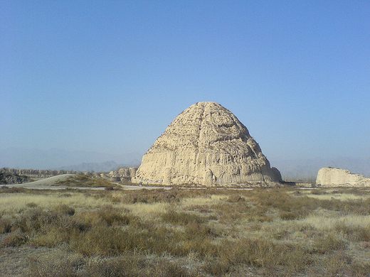

Besides the Great Pyramid of Giza, other rulers were buried in extravagant tombs and vast burial complexes. Some of these alternate pyramids were even in more interesting shapes.
The West Xia Imperial Tombs, are shaped like giant beehives and dot the valleys of the region. In the entire tomb area, there are 9 massive mausoleums, along with 250 lesser tombs. The mausoleums hold the remains of the imperial leaders of the Western Xia Dynasty. Beginning in 1038, the Xia Dynasty was extremely powerful until 1227 when Genghis Khan and his Mongol armies swept in from the North, wiping out any trace of the former empire.
Due to their quick and violent demise, research is only just beginning on the Xia Dynasty. In 1972, the first pyramid mausoleums were discovered in the area and most are still not fully excavated. From completed digs, researchers have learned that the main mausoleum belonged to the first emperor of the Western Xia, who died in 1048.
25 km from Yinchuan with buses departing from Beimen Bus Station at 8:30 and 9:30.
Getting there and time. I hired a taxi who waited for me, then drove me to the Ningxia Museum and waited. It is a 28 km drive taking 30 minutes.
Buy the ticket, see the museum, then walk about 1 km to a bus stop, wait 15 minutes, and take a 60-minute bus tour around the site. Narration only in Mandarin. Our bus had about 30 little kids. None of the tombs can be entered. This tour is missable and because of the time involved made for an expensive taxi as the meter was running all the time.
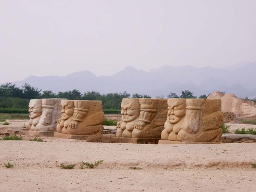
The museum is in another wonderful beautiful building with great displays and writing in English. There were great displays of the tombs and what they looked like. There were 9 imperial tombs (now only dirt 29m high, octagonal, beehive-shaped pyramids with many small vent holes that can’t be entered) and 271 secondary tombs. The imperial tombs were surrounded by a large rectangular wall with corner platforms and guard towers. The dirt tombs had elaborate wood stelae pavilions with 7 or so layers, a roof, and globed spire. There was a coffin chamber inside. There are two wonderful small rooms in the museum with all the walls and ceiling covered in frescoes.
Other exhibits were on printing presses and literature, Buddhism, Confucianism, coins, bronze casting, tools, The Yrozhaou kilns (for ceramics, functioned for 1400 years), 18 salt ponds (that supplied salt to the rest of China), an archaeological dig, and a massive collection of all kinds of ceramics, including large animals and elaborate “dragon” decorations for the roof eaves.
Cost: entry is only 60¥ (reduced). Taxi (including the museum with waiting and my ride to the airport the next day – over 30km, so a very good deal) 300¥
Ningxia Museum. Another wonderful building with a gorgeous interior and displays, showcasing the Silk Road (that Ninxia was an active part of), archaeology, ethnic and history displays. A lot of ceramics. Good English write-ups but all labels only stated the date, but not what the object was. Free
ON Holiday Inn Express Yinchuan Downtown. For a second night.
Day 11 Fri June 30
Flight. China Eastern Yinchuan T3 – Taiyuan @11:30-13:00 MU9954 CA$171. The same taxi driver picked me up at 09:30. It took 45 minutes to drive to the airport. She was very good.
Go to China – Central
I didn’t see
Badain Jaran Desert—Towers of Sand and Lakes. Tentative WHS
On the southern fringes of Badain Jaran and Tengger, two large deserts cover 85,000 square kilometres in China. Gansu, home to over 12 million hectares of sandy land, has been exploring a variety of new measures to bring a verdant look to the formerly barren land.
Photovoltaic panels provide shade for the plants, while efficient water-saving spraying facilities keep them thriving. More than 1,300 hectares of desert plants have been grown in the photovoltaic sand control demonstration park in Wuwei, building up a solid green barrier to boost sand control. They not only generate electricity and greens the sandy land but also increases local’s income.
Placing straw checkerboard barriers has also proved an effective method to battle desertification, as they help reduce wind speed and can hold water used to help plants grow. A new generation sand barrier laying machine is four to six times more efficient. Multiple giant sandstorm observation towers have been erected along the Hexi Corridor. A once dried-up lake in Minqin county has been revived and several desert zones are now lush and green. Desertified and sandy land in Gansu decreased by 2,627 sq km.
Chinese Section of the Silk Road Tentative WHS. Land routes in Henan Province, Shaanxi Province, Gansu Province, Qinghai Province, Ningxia Hui Autonomous Region, and Xinjiang Uygur Autonomous Region; Sea Routes in Ningbo City, Zhejiang Province and Quanzhou City, Fujian Province – from Western-Han Dynasty to Qing Dynasty (28/03/2008)
