
Australia – Queensland Sept 19-27, Dec 3-8, 2023
Road signs. In Queensland on #1, the Bruce Highway, overtaking (passing) signs were crazy. Every dashed line got Passing Permitted – When Safe, every solid line got Passing Not Permitted. Every passing lane had a few warnings, Overtaking Lane in 5 kilometers, 2 km, 500 m. Keep Left Unless Overtaking and then 2-3 signs to merge right at the end.
On the 247 km Lassiter Highway to Uluru (where there must be a lot of tourists driving), many seat belt signs in five languages written too small to read, followed by a Buckle Up sign with an icon. The worst was Drive On The Left in Australia (Uluru is thousands of km from anywhere and to get here, they must have driven on the left a lot).
Time zones. Winter time in Melbourne Australia is the same as Sydney and Brisbane – Easter Standard Time. During summer, the southern states, including Sydney and Melbourne, have daylight saving time, which leaves Brisbane an hour behind.
AUSTRALIA – QUEENSLAND – SOUTH (Brisbane, Rockhampton, Toowoomba)
Day 1 Tue Sept 19
I arrived from Port Moresby and took the train (A$21) to Fortitude Valley station and walked the 2 blocks to my hostel.
ON Bunk Brisbane. A$53/night in 10-bed share dorm. Very nice hostel.
Day 2 Wed Sept 20
I had a walk-about that was very pleasant seeing everything easily without great distances.
BRISBANE is the capital and most populous city of Queensland, and the third-most populous city in Australia and Oceania with a population of approximately 2.6 million. Brisbane is located in the hilly floodplain of the Brisbane River Valley between Moreton Bay and the Taylor and D’Aguilar mountain ranges.
Aboriginal groups claiming traditional ownership of the area include the Yugara, Jagera, Turrbal and Quandamooka peoples.
The Moreton Bay penal settlement was founded in 1824 at Redcliffe as a place for secondary offenders from the Sydney colony, and soon moved to North Quay in 1825 on the banks of the Brisbane River, so named for Sir Thomas Brisbane. German Lutherans established the first free settlement of Zion Hill at Nundah in 1838, and in 1859 Brisbane was chosen as Queensland’s capital when the state separated from New South Wales. By the late 19th century, the city had grown into a major port and centre of immigration. During World War II, the Allied command in the South West Pacific was based in the city, along with the headquarters for General Douglas MacArthur of the United States Army.
Brisbane is a major centre of research and innovation in the Asia-Pacific, particularly in medicine and biotechnology. A transport hub, Brisbane is served by large rail, bus and ferry networks, as well as Brisbane Airport and the Port of Brisbane, Australia’s third-largest seaport.
A diverse city with over 32% of its metropolitan population being foreign-born, Brisbane is frequently ranked highly in lists of the most liveable cities. Galleries and museums are an important part of the city’s culture, with the most prominent being the Queensland Art Gallery and Gallery of Modern Art. Brisbane has hosted major events including the 1982 Commonwealth Games, World Expo 88, the final Goodwill Games in 2001, the 2014 G20 summit, and will host the 2032 Summer Olympics and 2032 Summer Paralympics.
Brisbane is a popular tourist destination. Major landmarks and attractions include South Bank Parklands, the City Botanic Gardens, King George Square and City Hall, the Story Bridge, the Mount Coot-tha Botanic Gardens and Lookout and the Lone Pine Koala Sanctuary.
The Old Windmill. Sitting on the highest hill of Brisbane, this conical smooth stone mill has no windmill apparatus, just a wind vane on top.
Queensland Police Museum. In a police station, this has uniforms, guns, police paraphernalia, women police, dogs, horses, drugs, and some of the interesting cases dealt with by the police in Brisbane.
Kurilpa Bridge. This bridge crosses the Brisbane River. It is of unusual construction with one pier, 17 diagonal towers, and 12 horizontal beams all connected with wire.
Queensland Art Gallery. A wonderful art gallery with a broad range of Australian, and European artists. Some great small bronzes by all the masters. Free
Queensland Museum and Science Centre/SparkLab. One of the better science museums. The two main displays are good fossils/geologic history/dinosaurs and a great one on insects. Free
Queensland Maritime Museum. Has thousands of artifacts of machinery and ships from the Brisbane Dry Dock (Diamantina and a lightship can be visited), the maritime history of Brisbane, uniforms, maps, charts, books, models wooden boats, the Bulwer Lighthouse, and you name it. A$15
Goodwill Bridge. Another lovely pedestrian bridge over the Brisbane River of steel girder construction. Has a lovely sun shade like the Kurilpa Bridge. Goes under the Captain Cook Bridge at the north end.
Captain Cook Bridge. A four-lane highway bridge crossing the Brisbane River. Two piers with reinforced concrete support.
QUT Art Museum (Queensland University of Technology). Modern art. Some great ceramic busts, and several pieces about the use of words (cunt, shit, slut). Free
Next door is the Old Government House, a gorgeous building with the art of Willian Robinson.
Manor Apartment Hotel. A 9-story hotel constructed of pink/beige granite. A tiny lobby.
Cathedral of St Stephen. A lovely RC church, 3 naves, a wood arched ceiling over the altar, and Ways of the Cross modernist paintings behind plexiglass. The highlight would be the baptismal font, a curving piece of marble backed by carving of a woman and baby.
Museum of Brisbane. On the 3rd floor of the Brisbane City Hall, there is some history (mostly about the role of Brisbane in WWII as the Allied HQ for the Pacific when 300,000 soldiers moved through) and many photos of the city. Most was art – ceramics, paintings. Free
Albert Street Uniting Church. A lovely red brick/cream stone church with a very high single bell tower topped with a high conical roof. Unfortunately closed.
I ate at a very good restaurant, Santa Monica near Central Station.
ON Bunk Brisbane for a second night.
Day 3 Thur Sept 21
As my car was booked for today (I thought it was the 22nd), I decided to pick it up, stay at the hostel till the morning, and then down to Southport to see my cousin’s wife and get some credit cards. I spent the day reading, doing travel research, and talking to my cousin who lives in Bridgetown, south of Perth.
ON Bunk Brisbane for a third night. I met a young Israeli couple I had met at the Goroka show in PNG at this hostel. They are driving a rental car back to Cairns, pay only for gas, only allow 200 extra km, and have to do it over 4 days.
Day 4 Fri Sept 22
I was up early and left for Southport (Gold Coast) to see my cousin’s wife and get my credit cards at her townhouse at 9 am. I then saw the sites in Gold Coast before going south to the National Parks.
GOLD COAST
Wax Museum. The usual – famous people in authentic dress, chamber of horrors with torture implements, dioramas of Australian scenes and fairy tales, the Crown jewels, and a 150-year-old wax figure of Madame Tussaud. It costs $60,000 to make one figure. A$35
Q1 Tower (Queensland Number One) is a 322.5-metre (1,058 ft) supertall skyscraper in Surfer’s Paradise. It is a residential tower and was the world’s tallest residential building from 2005 to 2011 and is now the 14th tallest residential tower in the world, the tallest building in Australia, the second tallest building in the Southern Hemisphere, and the third-tallest free-standing structure in the Southern Hemisphere, behind the Autograph Tower in Jakarta, Indonesia, and the Sky Tower in Auckland, New Zealand. The Q1 officially opened in November 2005.
When measured to the top of its structural point (spire), it is ranked lower behind Melbourne’s Australia 108 (roof height of 316.7 m (1,039 ft)) and the Eureka Tower (roof height of 297.3 m (975 ft)) when measured to its roof height and highest inhabitable floor. When the Q1 was completed, it overtook the 21st Century Tower in Dubai, to become the world’s tallest residential tower. When measured to its structural point, it dwarfs the Gold Coast skyline, with the closest buildings to Q1’s height being the 220-metre (720 ft) North Tower of Circle on Cavill and the 243-metre (797 ft) Soul building.
It has a series of ribbons wrapped concentrically around the tower’s exterior and hover above the entry plaza area, providing cover and shade. The tension in the movement and free form are expressed by the gradual twisting of the aluminium-clad ribbons as they move around the building. The result is an open-air galleria-like shopping precinct under the glazed ribbon structure and a curved retail façade to the street edges. It has a glass-enclosed sleek look.
The building is supported by 26 piles, each two metres (six point six feet) in diameter, that extend 40 metres (130 ft) into the ground passing through up to four metres (thirteen feet) of solid rock. Q1 contains one-, two- and three-bedroom units. Building facilities include two lagoon swimming pools, a lap pool, a gymnasium, a small theatre, a ballroom and a spa centre.
SkyPoint, formerly known as QDeck, is an observation deck at levels 77 and 78, 230 m above the ground. It is Australia’s only beachside observation deck and has room for 400 people.
Gold Coast & Hinterland Museum. Only open on T, W, and Sundays, the gate was open and a lovely lady gave me a guided tour – Viever’s Settler cabin, Sheldon’s cottage artist studio (etchings), and the main building with a diverse collection of local memorabilia. Some of the more interesting were: this was the end of the trans-Pacific cable that starts in Bamfield on Vancouver Island (I have been there), a woman magician who won Penn and Teller’s magic show, sugar plantations, and a large collection of fashion by Gladys Moncrieff, still in fashion today. Free
I stopped at a Woolworth’s and bought a carload of groceries. At Jaycar, I bought an inverter to be able to charge my computer on the trip (A$200 with accessory cords to use the cigarette lighter).
HOTA. This is a large cultural complex with a theatre and art gallery. The gallery only had two floors open “Collects” (so-so modern art) and a history of the Gold Coast (surfing, bathing suits, fashion) told in a video and several good photos. Free
Gold Coast War Museum. War memorabilia, planes are fibreglass replicas, diorama models, medals, guns, patches, guns, uniforms, and a shop with many replica guns. It is more of a private collection than a real museum. It even has paintball. A$10
Day 66 Sat Dec 2
RETURN FROM NSW EASTERN
The Gold Coast Oceanway is a 36-kilometre network of shared cycle and pedestrian pathways along the coastline from the New South Wales border to the Gold Coast Seaway. The Oceanway provides access to beaches and offers sustainable travel options for residents and tourists along the city’s iconic coastline. The Oceanway path varies from 3.5m to 5m wide. Public facilities along the Oceanway include barbecues, seating, toilets, lighting, viewing platforms, showers and bike racks.
ON On the street beside the water in Tweed Heads.
Day 74 Sun Dec 3
I worked all evening and then till 09:30 on my South Pacific trip (it takes a lot of time).
Redland History Museum. A great community museum with an amazing amount of things – you name it and it has it – textile art, a trolley, a church, wagons, horse gear, cars, farm equipment, printing, guns, fishing, household everything, dolls, school room, and much more. $10, reduced $6
Fort Lytton. Now in a National Park, this has two small museums, the fort (1880-1945) – a small yard with grass banks, 2 disappearing cannon, tunnels, rooms and a moat (35′ wide and 8′ deep). Walk to the far corner to cross the moat on a small bridge. Donation.
I then drove through Brisbane, worked on my computer and the drove to a rest area on my way to Toowoomba. I have a lot of time till my flight leaves so decided to drive out this way, about 100 km west of Brisbane.
ON Wayside park in Gatton, on my way to Toowoomba.
Day 75 Mon Dec 4
TOOWOOMBA
Queens Park Botanic Gardens. Queens Park is a lovely, big urban park with grass and big trees. Next to is the botanical garden founded in 1874. They had just finished planting all the beds with 38,000 seedlings and 5000 bulbs – it will be a great flower show. There are 10 trees here over 100 years old and some very big ones – Queensland Kauri, pecan, California Redwood, Wollami Pine, Cypress, Bottle tree, Bunya Pine (every three years one tree will produce 100 cones, each with 70-80 bunya nuts, a favourite of the Aborigines), camphor laurel, and a Norfolk pine. A corner was taken over by the Christmas Wonderland with all sorts of Xmas decorations and food stalls.
Cobb & Co Museum. Both a vehicle and a Various Museum. Cobb & Co was started in 1854 by an American, Freeman Cobb to provide transportation during the gold rush of 1850. In 1911, their factory in Charlesville produced 35 kinds of carriages, but all closed down in 1924 with the coming of the automobile. Exhibits include a wonderful one on tea towels (sold as souvenirs), science, photographs of Wetlands, and the large National Carriage Collection with many wagons, and coaches of many kinds. $12.50. reduced $10.
Queensland State Rose Garden. In historic Newton Park, there are more roses here than I have ever seen – multiple beds, arbours and a large trellis. All beds have a sign with labels and dates.
ON Toowoomba
Day 76 Tue Dec 5
I had wanted to go to Bunya NP (Gondwana Rainforests extension) but it was 110 km to the northwest and too far. So I saw the last sites in Toowoomba.
Regional Art Gallery. Mainly local artists and some Aboriginal art. Nothing out of the ordinary. Free
Milne Bay Military Museum. Permanently closed (it had to move out of where it was and haven’t found a new location).
DownsSteam Tourist Railway & Museum. I had a lovely discussion with one of the volunteers who showed me around. Saw two locomotives, both in working order and ready to reinstate the Great Dividing Scenic Railway that will run from Toowoomba 200 km south. The cars that will be used are from the 60s and in good shape. $5
After a shower at the Milne Bay Aquatic Center ($2), I started my drive south to return to Brisbane. As I didn’t drive around much in Toowoomba, everything was discharged and I spent a few hours at a McDonalds in Gatton to recharge. An astonishing thing happened at the McDonalds. Three 15-year-olds dressed provocatively (one piece with short shorts and showing a lot of cleavage), ordered food and then put on the worst behaviour possible. One must have said “Give me my fucking money back 25 times at the top of her lungs”, all the time eating out of the takeaway bag. Another one tackled her and they both fell on the floor. The staff ignored them and they finally left with their food. Gas $1.78
I drove looking for someplace to sleep, turned off into a district with large acreages and arrived at The Fairways,
ON The Fairways, an elaborate park with playgrounds and many covered tables, maybe the nicest places I have stayed. I went to sleep very early and woke up at 3 am and worked on my travels.
Day 77 Wed Dec 6
A casual drive into Brisbane.
BRISBANE
I saw the only three things I had not seen on my first time here.
Sir Thomas Brisbane Planetarium, Toowong. Great models of all the rockets, space voyagers, detailed explanation of all the Solar system and planets, why Earth has life, Stars. The show in the planetarium was the Dark Side of the Moon $16, reduced $12.
Brisbane Botanic Gardens, Toowong. On Mt Coot-ha, this is one of the best gardens in Australia – Rainforest, Australian plants, Bunya forest, Queensland Trail and Gardens Explorer and many sub-gardens. One of the best floral displays. Free
Anthropology Museum. On the University of Queensland campus, this small museum has rotating exhibits from its collection. This exhibit had many Aboriginal objects (photos of sites from the air, before and after), model paddles and canoes, fishing nets, spear throwers, fire sticks, and three paintings. Diproodan (megafauna) mandible and thigh bones. Free
I washed and vacuumed the car, had a nap and continued work on South Pacific.
ON Yawaggera Park on the river. Quiet with great covered tables.
Day 78 Dec 7
My last full day in Australia. I was up early, packed my bag and leftover food, filled with gas, deodorized the car and returned it to Travelers Autobarn at 09:00. Taxi to Bunk Brisbane, dorm room. I had all day to continue working on the South Pacific trip, do laundry, get Australian money for Tuvalu, Nauru and Kiribati, download maps, copy country trips, and online check-in. I ate at the same restaurant I had my previous nights in Brisbane.
Total mileage driven in Australia Sept 21-Dec 8 – 24,897 km. Averaged 315km/day.
ON Bunk Brisbane A$50.
Day 79 Dec 8
Train to Brisbane Airport at 6 am. Flight Brisbane (BNE) – Honiara (HIR), Solomon Islands IE701@09:10-13:30
The Gondwana Rainforests of Australia World Heritage Area (extension to existing property) (07/05/2010). The Gondwana Rainforests of Australia World Heritage Area (the Gondwana Rainforests), inscribed on the World Heritage List in 1986 with extensions inscribed in 1994, is a serial property which consists of numerous reserves, in eight groups, along the coast and subcoast of mid-eastern Australia. There have been significant additions to national parks and other categories of protected areas in both New South Wales and Queensland.
Few places on Earth contain so many plants and animals whose form today remains relatively unchanged from that of their ancestors in the fossil record. There is a concentration of primitive plant families that are directly linked with the birth and spread of flowering plants over 100 million years ago, as well as some of the oldest elements of the world’s ferns and conifers. The second wave of flowering plants led to the most radical shift in the world’s vegetation when the relatively depauperate conifer forests were overwhelmed by the diversity of flowering plants.
Parks added as an extension:
Bunya Mountains National Park contains the main core of the Bunya Pine Araucarian forest one of the dominant plant species 50 million years ago. The Auraucarians are the most primitive of the world’s conifers, representing the ‘Age of Conifers’ in the Jurassic Period.
Richmond Range expresses the drier phase of the Border Ranges rainforest ecosystem; Carrai Plateau and escarpment adjacent to Werrikimbe National Park which include major examples of the “Macleay” dry rainforest.
Eastern Dorrigo Warm Temperate Rainforest which has Hoop Pine emergents and Nothofagus moorei at low altitudes;
Upper Manning Dry Rainforests
Tweed Caldera Gully Rainforests which have the highest diversity of species per unit area anywhere in NSW.
Mount Seaview Nature Reserve and Barrington Tops National Park
GONDWANA RAINFORESTS of AUSTRALIA WHS
Includes several protected areas along the Great Escarpment in 41 different parks. In southeast Queensland are Lamington National Park, Mount Chinghee National Park, Springbrook National Park, Mount Barney National Park and Main Range National Park. In northeast New South Wales are Barrington Tops National Park, Dorrigo National Park, Mount Warning National Park, New England National Park, Oxley Wild Rivers National Park, Washpool National Park, Willi Willi National Park and Werrikimbe National Park.
When Australia separated from Antarctica following the breakup of Gondwana, new asymmetrical continental margins parallel to the coastline eroded resulting in the Great Divide and the Great Escarpment. Volcanoes erupted in sequence along the east coast during the Cenozoic Era as the Australian continental plate moved over one of the planet’s hot spots resulting in the Tweed, Focal Peak, Ebor, and Barrington volcanic shields. Ongoing geological and biological processes produced marked biological diversity with ancient origins in Gondwana, many only found here.
The Tweed Shield erosion caldera is possibly the best-preserved erosion caldera in the world, notable for its size and age, has a prominent central mountain mass (Wollumbin/Mt Warning), and shows all three stages in the erosion of the caldera floor to basement rock.
Further south, the remnants of the Ebor Volcano also show ongoing erosion of a shield volcano.
Included are the oldest of the world’s ferns from the Carboniferous Period, Conifers from the Jurassic Period (Araucarians are the most ancient and phylogenetically primitive of the world’s conifers). Angiosperms include primitive flowering plants originating in the Early Cretaceous, the primary radiation of dicotyledons in the mid-Late Cretaceous, rainforests from the ‘golden age’ of the Early Tertiary, and Miocene vegetation, the antecedent of modern temperate rainforests in Australia.
Many songbirds: lyrebirds, scrub-birds, treecreepers, bowerbirds, and catbirds (some of the oldest lineages of passerines that evolved in the Late Cretaceous).
Plants and animals show relatively recent evolution. The rainforests provide a series of distinctive habitats showing an endpoint in climatic and geomorphological evolution. The distances between these ‘islands’ of rainforests represent barriers to the flow of genetic material for those taxa that have low dispersal ability. This pressure has created the potential for continued speciation. More than 270 threatened species as well as relict and primitive taxa.
Rainforests covered most of Australia for much of the 40 million years after its separation from Gondwana. These contracted as climate changed and the continent drifted northwards. By European arrival, rainforests covered only 1% with suitable climatic and protection from fire. Clearing for agriculture has resulted in only a quarter of the original remaining.
Protected are the largest and best stands of rainforest habitat, rare and threatened flora and fauna species that are rainforest specialists, a diverse range of heaths, rocky outcrop communities, forests, and woodlands. A high diversity of plants and animals in a habitat for rare threatened, and endemic species. Recently found and thought to be extinct: the Hastings River Mouse and Parma Wallaby.
The Gondwana Rainforests contains the largest and most significant remaining stands of subtropical rainforest and Antarctic Beech in cool temperate rainforests in the world, the largest warm temperate rainforest, and one of only two remaining large areas of Araucarian rainforest in Australia.
Small size and reasonable proximity with connecting corridors of semi-natural habitats and buffers make intensive management possible.
SPRINGBROOK NATIONAL PARK
Purling Brook Falls. A 106 m high waterfall but there was almost no water going over the falls. There are two overlooks, one on the east and one on the west both with a sideways view.
ON Camp at picnic area about 4 km from the waterfall. Pleasant night.
Day 5 Sat Sept 23
I was up early and started driving – GM took me on a crazy route to Yarrabilgong Falls, basically ending on a track over some grass into the bush. It was then 48 km to Lamington. NP
LAMINGTON NATIONAL PARK (Green Mountains)
Get in. From Brisbane via Canungra to the National Park Visitor Centre.
Centenary Track is 1.8 km, then 5 km to the Python Rock Lookout, 6.2 km to the Moran Falls Lookout. See many birds – Southern logrunner, the paradise riflebird, the grey and rufous fantails, the golden whistler, the Eastern yellow robin, the yellow-throated and white-browed scrubwrens, the Wonga pigeon, and two of the noisiest birds in the rainforest canopy: the Eastern whipbird and the green catbird.
Border Track has interesting information boards about the 23 million-year history of the park’s geology. Primitive conifers and ferns from when the last basalt lava flowed down from the 2000 m Tweed volcano. Some of these plant species survived from when Australia was still part of Gondwana some 200 million years ago.
Past the Border Track, continue to the Box Forest Circuit and part of the Binna Burra Track. See Picnic Rock and Elebana Falls. See Crimson rosella and the rare Lamington freshwater crayfish
O’Reilly’s – strangler figs and epiphytic plants.
Treetop Walkway Loop is 30 m high over the canopy. (Australian king parrot).
Sunset at one of the lookouts in Springbrook National Park. Less crowded than the Blue Mountains.
Waterfalls: Yarrabilgong Falls
On the way back to Brisbane, I bought a garbage can and bags at Woolworths, a new vape, and replaced my Patagonia 800-fill-down sweater (A$389).
Opal Museum. Australia’s gemstone. It produces 95% of the world’s opals. A great museum with a video on the fossil formation of opals, the other kinds of formation methods, all the mines in Australia (the most expensive, black opals, are produced only at Lightning Ridge. $5
Miegunyah House Museum. Home of the Queensland Women’s Historical Association, this gorgeous house has a lot of wrought iron tracery on the deck and eves. Inside is an eclectic collection of furniture, ornaments, art, ethnographic material, fashion, and biographies of famous Australian pioneers. The two ladies there invited me for tea. $15 (Miegunyah means “honey” in Aborigine)
Westfield Chermside. A one-level shopping mall with several big box stores and many smaller ones.
I left Brisbane on my way north.
Abbey Museum of Art & Archaeology, Caboolture. A wide-ranging collection showing the history of the world in a very well-curated exhibit. Most was collected in the 30s by an Englishman who donated it and had it shipped to Australia. It sat in a warehouse for 40 years and was finally put into this excellent museum. Several unusual and interesting pieces (I had never seen a beaded Egyptian mummy mask) and learned about the genetics of grains. $12
SUNSHINE COAST
Queensland Air Museum, Caloundra. 80 military and civilian aircraft. Can enter some. Not worth the $20 entry fee.
Caloundra Lighthouse, Kings Beach. Sitting on top of the highest hill in Caloundra in a residential neighbourhood, this is a small round corrugated metal LH that tapers to a small platform and a red top. Next door is a modern small tower that has a weather station.
NightQuarter. In the Urban Legends series, this is a collection of pink shipping containers arranged in a square with a high canopy roof. Many eating establishments and bars. Has been closed since Covid, but is looking for a new owner.
ON La Balsa Park. A lovely water-side park with picnic tables and a toilet, very close to the lighthouse. Very quiet and out of the wind at night but full at 06:30 on a Sunday.
Day 6 Sun Sept 24
I had a lovely BF at a picnic table on the water and walked up to the lighthouse.
Point Cartwright Lighthouse, Buddina. Built in 1979 as Caloundra was surrounded by buildings and not as visible (14 km north). 32 m high (on promontory 53 m above the ocean), pentagonal, white reinforced concrete, light visible for 20 nautical miles.
Next to the Point Cartwright Reservoir, 17 m high and 20 m diameter, painted with an underwater sea scene.
Many people fly wind kites and walk dogs and families. The parking lot is always full so park at La Balsa.
Sunshine Castle. Originally a local Scottish couple built the Fairy Tale Castle in 1972 to house eight original Fairytale Diaramas and some dolls. Now a Norman-style castle with a tower, doll displays, a medieval museum (mostly armour), treasure hunts, and an event venue. Not of much interest to me but cheap at Aussie prices. A$8
Big Pineapple, Woombye. In the NM Bizzarium series, this is a plastic construction with fairly authentic colour, although peeling in places. No entry. Lots of tourists taking pictures.
Nambour & District Historical Museum. A typical small town museum, with local history, a pack howitzer (used in Vietnam, could be carried by 12 mules), and a lot of machinery related to the sugar industry including several steam locomotives. $5
The Ginger Factory. Theme park owned by Buderim Foods, with displays about ginger, train & boat rides, a tropical garden walk & concessions.
This is only for kids. The parking lot and restaurant were full but I’m sure there is better food for cheaper. The boat and train are very juvenile ($13/10). Pay for a factory tour ($17.50/16 reduced) or a live bee exhibit (same prices). In the shop are many ginger products (power shots, pills) and local products.
Eumundi Market. Billed as Australia’s premier artisanal market, this large open-air market taking up five rows has locally made arts & crafts, and street food – “Make it, Bake it, Sew it, Grow it”. On Wednesdays and Saturdays since 1979.
NOOSA HEADS
This must have been a swamp at one time, now with all the water managed into a huge complex of channels and lagoons with a lot of high-end housing sitting on the miles of shore (and thus sand) created with all the channels.
Noosa Main Beach. Only about 500 m long but a very deep beach with golden sand. Full of people spread randomly, sunning, walking, beach volleyball (no chairs and umbrellas), many swimming in the mild surf. The urban area next to the beach was packed with people.
Regional Gallery. The present exhibit is called Experimenta Life Forms, 26 Australian and International artists working in diverse art forms – robotics, bio-art, screen-based works, and installations examining life in response to new scientific research and technological change.
What new life forms are emerging, are definitions of life shifting, First Nation’s view, sentience in animals, plant life, and with AI, perhaps soon in our machines?
It was a two-hour drive to Noosa heads through a flat, sandy area almost entirely planted with plantation trees, mostly pine. There were no towns. The road traveled on the edge of Great Sandy World Heritage Area Tentative World Heritage Site (04/01/2010). Except for a brief part of hard-packed gravel (excellent shape), the drive was on good pavement.
HERVEY BAY
ON Mango Tourist Hostel, Hervey Bay. $30 dorm room. This is the first hostel in the 1000+ that I have stayed in where the owner introduced himself with “Who the fuck are you?” But he turned out to be a fascinating guy with a wide range of geographical and travel knowledge.
Lovely kitchen window that folds up out of the way onto a lovely covered deck with a table.
Day 7 Mon Sept 25
Tour to Fraser Island. Fraser Tours – one-day tour A$275.
I was picked up at 07:15 by the tour company and taken to the ferry.
One-day tour.
Start at 07:15 and end at 6 pm, 4WD to visit:
The order depends on the tides – drive 75 mile Beach at low tide. We drove across the island with a constantly changing forest to K’gari Beach Resort. The best rainforest, called Pile Valley, has satinays to 40 m high, and kauri pines.
1. 75-Mile Beach. Nicknamed “the Ocean Highway” as used to drive along the entire East Coast. We entered at a point 30 km from the south end. Has a speed limit, normal road rules, and a police station. No swimming due to currents and undertow.
2. Maheno wreck – a cyclone in the 1930s beached this rusting wreckage. This was a fast passenger ship running a route between NZ and Australia. In WWI, it took people between England and Egypt. By the 30s it was deemed unseaworthy, bought by a Japanese company, and was being towed when it ran into a cyclone. It is now just a rusting superstructure, about 60% below the sand. s
3. The Pinnacles (Colored Sands). Due to the oxidation of iron and minerals, it is mainly yellow and cream. Sacred to the Butchulla.
4. Eli Creek. A very shallow freshwater creek near the wreck. Has a free natural water park with an inner tube to float down the swiftly flowing creek to the ocean. 35 minutes here. Fed by the aquifer, one of the largest in the world. The water in the aquifer took 80 years to filter down through the sand. Eli Creek probably had 100 vehicles parked.
Buffet lunch at K’gari Resort on the east side of the island.
5. Central Station. Where the main community on Fraser was from 1920 to 1951. About 30 homes for the loggers. Now the starting point for an 800 m long walking trail along Wanggoolha Creek (sacred as women birthed here and men not allowed; crystal clear water on sand base) with tall gum and eucalyptus trees, king ferns (300 million years old), Blue-winged Kookaburra.
6. Lake McKenzie (Boorangoora) is one of about 40 perched dune lakes with white silica sands. 130 hectares (quite big) and up to 11 m deep. Has frogs, and turtles but few fish. Everyone is forced to swim, crowded, and can be unbearably hot.
At the end return the same way to the Kingfisher Resort and the ferry.
Another option. Fraser Tours and Fraser Experience are the two companies that run tours like mine, primarily on the East Coast.
Tasman Venture is the only company offering tours to the west coast. It is called Remote Fraser and by catamaran and a small tender (1 day, $210 – 9 km of pristine white beaches, kayak, snorkelling, seclusion, and whale watching, also dolphins, turtles, dugongs, and birds). Visit Moon Point, Bowarrady Creek, Awinya Creek, Coloured Sands, and Wathumba Creek.
Fraser Explorer (2-day combined with the east side trips). They will also let you bring your own camping equipment and venture on your own for free (they even give leftover food from their buffet lunches). 1 800 620 322, [email protected], tasmanadventure.com.au.
Multi-day tours see Indian Head lookout, Kirrar sandblow, hikes to Lake Wabby, shifting sands at the Hammerstone Sand Blow, and other perched lakes.
Marloo Bay has Waddy Point, the only rocky headland. Champagne Pools – swim.
Indian Head has a great panoramic view of the sand dunes and beaches behind and the ocean in front (see sea turtles, sharks, and manta rays). White-bellied sea eagles.
Also is a 30-minute scenic flight (80$) to see the never-ending beach, dunes, and creeks (Butterfly), and many sharks and rays offshore from above.
Many more people see Fraser Island by private 4WD vehicle. Buy a permit for $60 that lasts a month. They cause traffic jams on the narrow roads. Most come equipped to camp for several days.
K’GARI (FRASER ISLAND) WHS lies just off the east coast of Australia. At 122 km long, 22 km wide at its widest, and 181,851 hectares, it is the largest sand island in the world. There are also a number of small adjacent islands The boundary extends 500 metres seaward from the high water mark around K’gari (Fraser Island) and smaller islands.off the west coast (Stewart and Dream Islands). Majestic remnants of the tall rainforest at elevations up to 240 metres growing on the sand in coastal dune systems is unique. Half the world’s perched freshwater dune lakes (exceptional in terms of number, diversity, and age) are found inland from the beach. The combination of shifting sand dunes, tropical rainforests, lakes, and the world’s largest unconfined aquifer on a sand island makes it an exceptional site.
It has 250 km of clear sandy beaches with long, uninterrupted sweeps of ocean beach, strikingly coloured sand cliffs, and spectacular blowouts, also unique in the world.
The immense sand dunes are part of the longest and most complete age sequence of coastal dune systems in the world and are still evolving. The superimposition of active parabolic dunes on remnants of older dunes deposited during periods of low sea level, which are stabilized by towering rainforests, is considered unique.
Soil formation is also unique, a result of the successive overlaying of dune systems, a chronosequence of podzol development from the younger dune systems on the east to the oldest systems on the west change from rudimentary profiles less than 0.5 m thick to giant forms more than 25 m thick that exceed known depths of podzols anywhere else in the world. The older dune systems cause retrogressive succession as the soil horizon becomes too deep to provide nutrition for tall forest species.
Both heathland and closed forest communities provide refuge for relict and disjunct populations. Evolution and specialized adaptation to salinity, low fertility, fire frequency, waterlogging, water table, age, nutrient status of sand dunes, and aridity.
Patterned fens here are the only known examples of sub-tropical patterned fens in the world. These fens support an unusual number of rare and threatened invertebrate and vertebrate species. The low shrubby heaths (‘wallum’) are of considerable evolutionary and ecological significance.
Fauna including a number of threatened species of frog, have adapted to the highly specialised acidic environment. Few mammal species occur. Dingoes were once common on the island, but are now decreasing. About 200 remain. They are one of the more pure strains.
There are no kangaroos (no grasslands) and no koalas (none of the eucalyptus species they prefer), no platypus
The majority of the island is in a National Park, and all of the marine area is in Great Sandy Marine Park.
Birds are the most abundant form of animal life with over 230 species mostly migratory wading birds who use the area as a resting place during their long flights between southern Australia and their breeding grounds in Siberia.

The increased recognition of the Butchulla people as its traditional owners makes it more special. The Butchulla used it seasonally with up to 2000 living here in season. There has been no Butchella community here since 1904.
Get in. Most of the tour companies operate from Noosa Heads, Rainbow Beach, and Hervey Bay. Noosa Heads and Rainbow Beach have a much earlier ferry, with a long, bumpy drive on the island.
Strictly limited to 4WD with no public transport (best to sit in the front as less bumpy and has better views).
Accommodation.
Noosa Heads
Urangan has a good beach and a relaxed vibe
Rainbow Beach to sleep the night before.
Two resorts on the island 1. Eurong Beach Resort is cheaper near 75 Mile Beach. 2. Kingfisher Resort.
Backpackers at hostels sometimes rent a 4WD and take the ferry to the island. The cheapest is camping in well-maintained campsites.
ON Mango Tourist Hostel, Hervey Bay. My second night here. As I returned from the tour to Fraser at 18:00, it made no sense to move on, and this was as cheap accommodation as could be found anywhere in Australia.
Day 8 Tue Sept 26
I sat around all morning doing business and then had a 2 1/2-hour drive to Bundaberg.
Hervey Bay Historical Village & Museum. Many relocated buildings creating a “town” – 1890 church visitor center, slab cottage, linotype and mattress making, harness, cottage, 1910 church, 1920 garage, stables, ropes cobblers, collections, shops from the 1920s, fishing. A$20
Flying High Bird Sanctuary, Apple Tree Creek. I didn’t go here as expensive at $25. Read the care is not great. People spend a lot of money on feeding the birds. Also has farm animals. More for kids but I think they get the wrong idea about feeding wildlife.
BUNDABERG
Zoos: Bundaberg West: Alexandra Park Zoo
ON Aaok Riverdale Caravan. 6 Perry St, Bundaberg.
Day 9 Wed Sept 27
LADY MUSGRAVE ISLAND is a 14-hectare (35 acres) coral cay on Australia’s Great Barrier Reef, with a 1,192-hectare (2,950 acres) surrounding reef. The island is the second southernmost island in the Great Barrier Reef chain of islands (with the first (southernmost) being Lady Elliot Island). The Island is named after Lady Lucinda Musgrave, the wife of Sir Anthony Musgrave, a colonial governor of Queensland.
Lady Musgrave Island, and the immediate surrounds, is a national park and can be reached by excursion boat from Bundaberg (located approximately 4 hours north of Brisbane) and from the Town of 1770, Queensland (located approximately 5 hours north of Brisbane). The island is part of the Capricornia Cays Important Bird Area.
Lady Musgrave Island is referred to as Wallaginji by local Australian Aboriginal tribes. The name Wallaginji means ‘beautiful reef’.
This island is the only shingle cay situated on the leeward reef flat. The island also has beach rock that is exposed along the northeastern and eastern beaches and an outcrop of lithified coral conglomerate, similar to that forming the core of the cay, occurs near the southeastern corner.
Vegetation consists of Pisonia grandis, Tournefortia argentea, Casuarina equisetifolia, and Pandanus tectorius. The vegetation is less dense than that of the larger sand cays of the Capricorn Group.
A small pond of brackish water is located towards the southern end of the cay. The island is located on the southern end of a large lagoon. From a boating perspective, a good thing about the Lady Musgrave reef is that one can enter the lagoon via a deep water channel.
Lady Musgrave Island is serviced by two operators offering day trips – Lady Musgrave Experience from Bundaberg and 1770Reef from the Town of 1770.
Guano mining occurred here in the 1890s.
Camping. In Capricornia Cays National Park camping is permitted on four cays: North West Island (150), Lady Musgrave Island (40) Masthead Island (60 campers, 30 from October to March). The island has no fresh water supply, so visitors need to bring all fresh drinking water. Camping must be booked up to 11 months in advance. The daily (subject to weather) tourist boat from 1770 can resupply campers with prearranged supplies.
Stargazing is spectacular.
Fauna. There are an enormous number of birds on the island. white-capped noddy terns nest in abundance in the Pisonia trees whilst bridled terns, black-naped terns, and silver gulls nest on the ground in more open areas nearer the beach. The carcasses of noddy tern chicks that fall out of nests or adults that become tangled in the sticky Pisonia seeds are quickly devoured by centipedes and the nutrients eventually returned to the soil. From December to May, migratory wedge-tailed shearwaters, colloquially known as ‘mutton birds’, nest in burrows in the interior of the island, and their mournful wails can be heard at night. These birds are readily seen along the forest walk at night and precaution must be taken to not stray from the path as the burrows easily collapse under the weight of a person. From September to March, migratory shorebirds such as ruddy turnstone, grey-tailed tattler, wandering tattler, bar-tailed godwit, Pacific golden plover, and lesser sand plover can be seen foraging on the reef flat at low tide. Buff-banded rails, white and grey phases of the eastern reef egret, pied oystercatchers, sooty oystercatchers, and Capricorn silvereyes are resident on the island year-round.
The island is a nesting place for green and loggerhead turtles. Small whitetip reef sharks and leopard sharks can often be found hunting in the shallows around the island. Green and leatherback turtles can be spotted resting on coral bommies, and the coral lagoon is a haven for a multitude of fish and coral species and a spectacular destination for anyone interested in snorkeling. 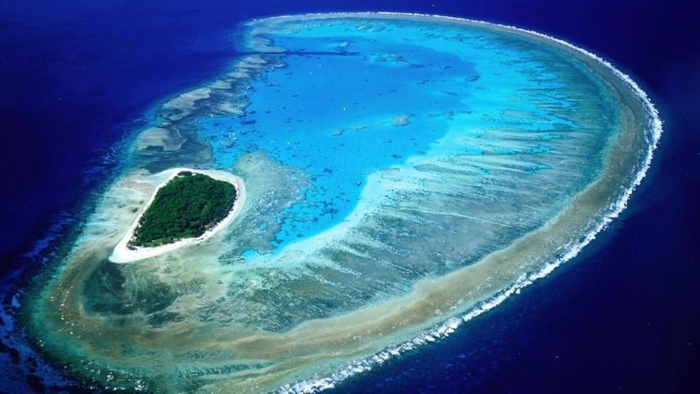
GREAT BARRIER REEF WHS
The Great Barrier Reef is a site of remarkable variety and beauty on the north-east coast of Australia. The area has been exposed and flooded by at least four glacial and interglacial cycles. Reefs have grown on the continental shelf for 15,000 years. During glacial periods, sea levels dropped, exposing the reefs as flat-topped hills of eroded limestone. There are some 2,500 individual reefs of varying sizes and shapes, and over 900 islands, ranging from small sandy cays and larger vegetated cays to large rugged continental islands rising, in one instance, over 1,100 m above sea level. The continental islands support thousands of plant species. The shallower marine areas support half the world’s mangroves and seagrass species.
As the world’s most extensive coral reef ecosystem, it covers an area of 348,000 square km extending across a contiguous latitudinal range of 14o (10oS to 24oS) – from beneath the Torres Strait to just above Fraser Island. From the low water mark along the mainland coast up to 250 km offshore, the wide depth range includes vast shallow inshore areas, mid-shelf, and outer reefs, and beyond the continental shelf, oceanic waters over 2,000 m deep. One-third of the GBR lies beyond the seaward edge of the shallower reefs.
400 species of corals in 60 genera range from inshore fringing reefs to mid-shelf reefs, and exposed outer reefs, in continental islands, coral cays, and reefs molded by changing climates, sea levels, and the erosive power of wind and water, over long time periods.
There are over 1,500 species of fish, 4,000 species of mollusk, plus a great diversity of sponges, anemones, marine worms, crustaceans, and other species.
242 species of birds of which twenty-two breed on cays and some continental islands.
Vegetation on the cays and continental islands host birds, such as the Pied Imperial Pigeon, important for seed dispersal and plant colonisation.
It is one of a few living structures visible from space, appearing as a complex string of reefal structures along Australia’s northeast coast.
The Whitsunday Islands are green vegetated islands and sandy beaches spread over azure waters. Whitehaven Beach and Hill Inlet on Whitsunday Island for snorkeling/diving. Swimming with manta rays, dolphins, turtles, sharks, and colourful reef fish. Hinchinbrook Channel is next to Hinchinbrook Island and has rugged vegetated mountains and lush rainforest gullies.
Many cays have breeding colonies of seabirds and marine turtles. Raine Island is the world’s largest green turtle breeding area. On some continental islands, large aggregations of over-wintering butterflies periodically occur.
Cod Hole near Lizard Island has annual coral spawning, migrating whales, nesting turtles, and significant spawning aggregations of many fish species.
Aboriginal and Torres Strait Islanders have contributed shell deposits (middens) and fish traps, plus the application of story places and marine totems.
Major feeding grounds for threatened dugong, 30 species of whales and dolphins occur, and humpback whale calving.
Six of the world’s seven species of marine turtle occur in the GBR. As well as the world’s largest green turtle breeding site at Raine Island.
The globally unique array of ecological communities, habitats, and species makes it one of the most complex natural ecosystems on earth. No other World Heritage property contains such biodiversity. Nothing is comparable in size and different hues of blue/turquoise, water clarity, variety, and amount of marine life.
Natural pressures include cyclones, crown-of-thorns starfish, and sudden large influxes of freshwater from extreme weather events. Tourism, shipping, and coastal developments including ports.
Get there.
Access from Cairns (Hamilton Island by boat, plane, and helicopter), Townsville, Port Douglas or Brisbane. The flight from Brisbane has an incredible aerial view of both Fraser Island and the GBR. Group excursions and helicopter/seaplane tours from Hamilton Island/Airlie Beach is Cruise Whitsundays.
Excursions aren’t cheap and distances require full-day trips. Snorkeling at Heart Reef and Heart Pontoon was incredible.
Cairns is not recommended for access to the Great Barrier Reef as more coral is bleached and visibility is reduced. It has high rainfall making the water siltier. It is closer to the reef and accentuates the same problem. The aerial view is not nearly as good. If you’re looking for the heart of the Great Barrier Reef, you’re in the wrong place!
There are also more people here due to daily international flights from China, Hong Kong, Taiwan, Singapore, South Korea, Indonesia, Japan, etc.). Good access to Cape Tribulation and Daintree National Park. Coral bleaching since 2016 has affected up to 80% of the reef, most noticeably more to the north. As the coral is much more intact the farther south, I was quite excited to hear about Lady Musgrave Island.
Lady Musgrave Island tour. Full-day tour: Snorkelling, swimming with Turtles, Reef presentation, Glass Bottom Boat Reef Tour & Guided Island Walking Tour. VIP upgrades and Scuba diving options are available. Departing Bundaberg Port Marina (15/17 Marina Drive). 7:15 am daily. Duration: 10 hours. Cost: A$250. I added one dive for $70 but changed my mind once I saw what the diving would be like. With tax, the entire day was $260.
My experience. It took about 2 hours to boat to Lady Musgrave. It was a perfect day with little wind and minimal swell. The people were divided into 5 groups of about 40, each rotating through the various attractions. I ended up with the best rotation which ended with snorkeling.
On arrival, my group headed for the island in the glass-bottomed boat. We walked across the island on a shady path and the excellent guide gave great explanations. The main tree are poidian, a large tree that roots itself from its branches. it has formed a symbiotic relationship with the white-capped nottie tern. The tern supplies guano for the tree and the tree provides branches for the tern to build its nests, The male brings leaves – only about one in ten is deemed acceptable and the female builds the nest from the leaves binding it all together with guano. Most of the seabirds build their nests in the ground. The burrowing shearwater digs a 2 m-long tunnel. There were several walking around in the bush and two other kinds of tern who had ground nests.
We returned to the start point on the beach which consists of a lot of coral and sand. The turtles lay eggs just inside the tree line hoping for the right amount of sun to produce the right temperature which when correct results in about 60% females and 40% males.
Back on the glass-bottomed boat passing over two turtle cleaning stations in the fibriated coral. Cleaner wrasses remove the moss and bacteria from the shells of the green turtles. We saw about 5 turtles in total.
The coral is surprisingly very dull in colour. It is all very healthy here with no bleaching but is about 95% white or muddy brown. There are small patches of brilliantly coloured coral – blue, purple, and red. The branching coral that was actively growing had lovely blue tips.
On return to the stationary boat, we had a very good buffet lunch. I then made a decision to not dive and asked for a refund of my $70. The reef is quite shallow and diving would only give marginally better views. The bland colour of the coral also made diving less spectacular.
I went snorkelling twice for about 45 minutes each time. Follow the edge of the reef to a narrow channel that gives access to a large open area with the best fish. There was a huge number of different species. I had a thrill swimming above a hawksbill turtle for about 15 minutes. The tide was exceptionally low and more coral was exposed than normal making it necessary to exit the larger lagoon through the same channel.
The trip back was uneventful. Tea was served.
After getting off the boat, I started to drive north, mostly in the dark.
ON Highway wayside.
Day 10 Thur Sept 28
ROCKHAMPTON
Rockhampton Botanic Gardens. Opened in 1869, this lovely botanical park has many big trees (a great stand of interconnected figs, many palms, a Bunya pine, and baobabs), a Japanese garden, a lake & a variety of tropical plants. A central cenotaph with a big obelisk details all of the Australian wars including the Boer War, Malaysia, Indonesia, Vietnam (1963-72), and the Long Tan episode in 1966. Many birds. Free
Rockhampton Zoo. In the botanical gardens, the showcased animals are several aviaries, eagles, otters, emus, cassowary, meerkats, chimpanzees, kangaroos, and koalas. Free
Archer Park Rail Museum. Museum in an 1899 railway station featuring a vintage steam, tram & other transport memorabilia. $10 (note it opens at 10 not 9)
Central Queensland Military Museum. Detailed artifacts from military deployment in clean displays in the original barracks and military HQ dating over 100+ years. A lot of uniforms, medals, guns, bullets, posters. The trench art was the highlight. $6
John Leak monument. First World War, Private John Leak (1892-1972), Victorian Cross recipient, brave, courageous, and a war hero. There are four stones with metal plates that have information of the battles fought by Australians in WWI.
This is a lovely monument – a trapezoid with mosaics on both sides. In 1916 at the Somme, in the Battle of Pozieres, Leak single-handedly charged a German post, threw bombs, and bayonetted 3 living Germans. In 42 days, 23,000 ANZACs died in this battle. He was a renegade charged twice with disorderly conduct and went AWOL.
Kershaw Gardens. Showcase for a variety of trees, shrubs & herbs, rainforest sections, wetlands with 3 ponds, a waterfall, walking paths & a camping area. Free
Rockhampton Heritage Village, Parkhurst. Many relocated original and reproduction homesteads, buildings, and businesses as well as memorabilia and artifacts portraying life in the region from the 1850s to the 1950s. There are many vintage cars, tractors, fire engines, and horse-drawn vehicles and wagons on display, watch how a 1950s print press works, and visit the Blacksmith Shop. There is a range of transport options including horses and ponies, a horse and cart, and a vintage double-decker bus. $5
Capricorn Caves is a multi-generational family-owned attraction located 23 km north of Rockhampton and just minutes off the Pacific Coast Way. The intimate Adventure Tour allows further exploration with breathtaking views from the summit and a true bucket-list experience. The basic tour is A$37.59 and two other advanced trips $75 and $80. I didn’t go.
GO TO QUEENSLAND – NORTH
==============================================================
AUSTRALIA – QUEENSLAND – NORTH (Cairns, Townsville, Mackay)
MACKAY
Mackay Regional Botanic Gardens. Quite small but lush tropical foliage. Much is a walkway along lagoons with lilies and nice plantings. Bamboo, grasses, ferns and many palms. Free
Artspace Mackay. Has several exhibitions: Zanny Begg’s videos explore contested histories, including ‘The City of Ladies’, ‘The Beehive‘, and ‘Stories of Kannagi’.
Kara Day looks at feminine stereotypes using textiles (quite clever), sculpture, and watercolour, Stephen Homewood has drawings, paintings, and prints of waterscapes using sharks and surf lifesavers. Free
Mount Pelion. 381 metres (1,250 ft) above sea level to the southeast of the town. The mountain was named by surveyor William Charles Borlase Wilson after the Greek mythological Mount Pelion. The locality and railway station take their name from the mountain.
Proserpine Historical Museum, Proserpine. I didn’t go. Proserpine is the gateway to the Whitsundays in Great Barrier Reef.
ON Mango Wayside. Lovely on the ocean.
Day 11 Fri Sept 29
I was driving by 06:30.
Ayr Nature Display. Ayr. Don’t miss this, the personal collection of Allan Ey. An ornithologist, he also collected shells, butterflies, moths, beetles, cockroaches, crabs, snakes, rocks, coral, carved wood cups, etched emu eggs – you name it – and displayed it artfully in one room that is 5X25 metres. Every square inch is covered including the ceilings with butterflies cut from stone. Most are in personally constructed glass cases. His daughter showed me some of the interesting pieces like the largest crab in the world and poisonous cone shells. $5
TOWNSVILLE (pop 179,011) is the largest city in North Queensland and is unofficially considered its capital. It is in the dry tropics region of Queensland, adjacent to the central section of the Great Barrier Reef. The city is also a major industrial centre, with one of the world’s largest zinc refineries and a nickel refinery. The Port of Townsville is an increasingly important port due to its proximity to Asia and major trading partners such as China.
Popular attractions include “The Strand”, a long tropical beach and garden strip; Riverway, a riverfront parkland on the banks of Ross River; Reef HQ, a large tropical aquarium holding many of the Great Barrier Reef’s native flora and fauna; the Museum of Tropical Queensland, built around a display of relics from the sunken British warship HMS Pandora; Castle Hill or as it was originally known Cootharinga, the most prominent landmark of the area and a popular place for exercise; The Townsville Sports Reserve; and Magnetic Island, a large neighbouring island, the vast majority of which is a national park.
The Palmatum, Annandale (just outside Townsville). A lovely park opened in 1988. The rainforest looks very natural, not like a garden at all. Many gazebos, rock fountains, and memorials. Free
Maritime Museum. Covers WWII, the Coral Sea Battle, HMS Magnetic, women telegraphers, Townsville women at war, navigation, and famous ships including the Titanic. $12, $8 reduced.
Victoria Bridge. This wide pedestrian bridge over Ross Creek sits on iron girder joists and piers. It has benches and flags. Sitting next to the bridge is a memorial to Eddie Mabo, an aboriginal activist (lovely fingerprint rock, drum, and mosaic).
Museum of Tropical Queensland. The second floor has exhibits on dinosaurs, fossils, coral, insects, birds, and the rainforest. The third floor has a large exhibit on the ship, the Pandora that was sent to look for the mutineers from the Bounty, but sunk with most of them dying. It missed the ones that landed on Pitcairn. Free
Queen’s Gardens. A large urban park, mostly grass and large trees but there is a nice rose garden in the middle.
Army Museum North Queensland. In Jezzine Barracks, home to Australian military units for over 120 years, there are three parts: The history of the Australian Army in North Queensland from the late 1800s until the end of the Boer War. World Wars I and II, including a WWI trench, western front tunnels, and gun emplacements used in Townsville during World War Two. The third exhibit is on Korea, Vietnam, East Timor, the Solomon Islands, and the Middle East. Free
Note that it is open on W, F, and Sunday from 9-1 with the last entry at 12:30. I arrived at 12:31 and only by whining did the elderly volunteer let me in. Free
Townsville Museum Inc. Townsville since the 1860s with exhibits before electricity, businesses, coastal radio, a pharmacy, an organ, printing presses, dolls, and the lovely City Hall stained glass window. $10 Note that it closes at 2:30.
WET TROPICS of QUEENSLAND WHS
894,420 hectares of mostly tropical rainforest, it stretches along the northeast coast of Australia for 450 km. Its rich and unique biodiversity reflects the ecological and evolutionary processes. Relics of the great Gondwanan forest that covered Australia and part of Antarctica 50 to 100 million years ago. All of Australia’s unique marsupials and most of its other animals originated in rainforest ecosystems, and their closest surviving relatives occur in the Wet Tropics. Demonstrates the process of evolution especially Australia’s sclerophyll flora and marsupial fauna.
At their latitudinal and climatic limits, they have a dry season and frequent cyclones, extremely high but seasonal rainfall, diverse terrain, and steep environmental gradients. There are forest vistas, rivers, waterfalls, rugged gorges, and coastal scenery especially between Daintree River and Cedar Bay where white sandy beaches and fringing offshore coral reefs add to the diversity. The winding channels of the Hinchinbrook Channel contain extensive mangroves and a terrestrial continuum with the Great Barrier Reef.
All major stages in the evolution of land plants, from the very first pteridophytes more than 200 million years ago to the evolution of seed-producing plants including the cone-bearing cycads and southern conifers (gymnosperms), followed by the flowering plants (angiosperms). All of Australia’s unique marsupials, songbirds, and most of its other animals originated in rainforest ecosystems.
Its tall, open forests on the drier western margins show the evolutionary continuum of rainforest and sclerophyll forests. Eucalypts, which now dominate the Australian landscape, evolved from such rainforest stock and radiated into drier environments.
The high level of diversity has 3,000 vascular plant species in 224 families (576 species and 44 genera are endemic). Vertebrates include 107 mammals (11 endemic species and two genera). There are 368 bird species (11 endemic), 113 reptiles (24 endemic), and 51 amphibians (22 endemic). Many marsupials, frogs, and reptiles have restricted distributions. The flightless Australian cassowary is one of the largest birds in the world.
The Wet Tropics cover less than 0.2% of Australia but contain 30% of the marsupial species, 60% of bat species, 25% of rodent species, 40% of bird species, 30% of frog species, 20% of reptile species, 60% of butterfly species, 65% of fern species, 21% of cycad species, 37% of conifer species, 30% of orchid species and 18% of Australia’s vascular plant species. It is fringed and in a few places by sclerophyll forests, woodlands, swamps, and mangrove forests, adding to its diversity.
The level of human impact is low, with 80% of the estimated cover originally present at the time of the first European settlement remaining as logging has been prohibited since 1987. Transmission lines, access roads, abandoned mine sites, and selectively logged areas remain. There have been invasions of exotic plants, animals, and forest diseases. Climate change with even a small increase in temperature is expected to cause large declines in the range for almost every endemic vertebrate species present.
From Cairns. It is an easy day trip from Cairns to Karunda and the Skyrail Rainforest Cableway Terminal in Smithfield. The ride of 7.5 km over the rainforest canopy takes 40 minutes. Red Peak Station is the highest point at 545 metres above sea level and there is a 200-meter boardwalk where you can easily see Atherton Tablelands, primitive fern-like cycads, elkhorns, stag horns, bird’s nest ferns, Kauri pines, Alexandra palms, Caribbean pine trees, fan palm trees, a variegated fig, and a banyan tree, apart from several metallic starlings.
Barron Falls Station is in lush, complex rainforest (basket ferns and Cooper’s tree ferns). The best views from the cable car are between Towers 25 and 27. Three lookouts provide panoramic views. Many butterflies and cicadas (the largest endemic butterfly, the Cairns birdwing). Torresian imperial pigeon, the Eastern whipbird, the Chowchilla, and the common rainbow lorikeets. See trees, epiphytes, and a few birds but you don’t gain a better feel for the “forest”. The cars move at a fair speed and the 2 stops are very short.
As the most diverse rainforest in Australia because of different soil types, altitudes, rainfall, and evolutionary histories. The Barron Gorge Hydro-Electrical Station controls the flow of water to the falls.
The Skyrail Cable Car ends at Kuranda, a small touristy village in the rainforest.
River and ‘jungle’ walk to Jumrum Creek (3km). Cruise on the Kuranda River Boat is probably not worth the 18-dollar fee.
Kuranda Scenic Railway (90 minutes back to Cairns. Stops at Barron Falls and Stoney Creek Falls. Constructed between 1882 and 1891 and is an engineering feat with 15 hand-made tunnels and 37 bridges, 37 km long, climbs 328 m in about 20 km, a scenic stop at Barron Falls and another at Freshwater on the plain a few miles outside Cairns for “transit” passengers. 2/3rds has good views down into the gorge and up to the waterfalls above. Better advised to arrange a walk on trails in Barron Gorge Park which starts only a few miles outside Cairns. 101 A$ to do cable car and train.
Other nearby destinations.
Daintree River with its overhanging foliage, birds, and crocodiles.
Cape Tribulation Beach, where the rainforest meets the reef.
Lake Barrine cruise to see tall trees, fish, eels, snakes and turtles
Curtain Fig Tree near Yungaburra with its aerial root system high up in the foliage.
Wooroonooran National Park with its tree-top walk.
Cairns/Port Douglas coastline is lovely, the coastal mountains have many waterfalls and once you pass the tablelands you’re in the fantastically empty Outback. Mossman gorge.
National Parks included are
- Barron Gorge National Park
- Black Mountain National Park
- Clump Mountain National Park
- Crater Lakes National Park
- Curtain Fig National Park
- Daintree National Park
- Danbulla National Park
- Dinden National Park
- Djiru National Park
- Girramay National Park
- Girringun National Park
- Herberton Range Conservation Park
- Koombooloomba National Park and Koombooloomba Conservation Park
- Kuranda National Park and Mowbray National Park
- Kirrama National Park
- Kurrimine Beach National Park
- Macalister Range National Park
- Mount Hypipamee National Park
- Mount Lewis National Park
- Paluma Range National Park
- Russell River National Park
- Tully Falls National Park
- Tully Gorge National Park
- Wooroonooran National Park
I saw the following sections of the WHS
Paluma Range NP. Jourama Falls is a 6 km drive off the highway, about 2.5 km of it on dirt. Cross the lovely creek twice, pass the nice campground and park. It is a .75 km walk to the falls, the last 600 m uphill to a viewpoint well below the three-tiered falls. Pass cycads, bottlebush palms, and many white eucalyptus trees. There are great swimming pools in the gorge below. The trail is interesting as it is “paved” with hexagonal rubber mats.
Girramay NP. There are three sections to this park. The Edmund Kennedy section (he was the first explorer in this part of Queensland in 1866) is next to the ocean and accessed by a 4.5 km dirt road. The park has wetlands, some rainforest, melaleuca woodlands, and mangroves. The beach is quite nice with steep golden sand. It is home to the Southern Cassaway and mahogany glider, a severely endangered type of possum with only 1500 members.
ON A highway rest area about 22 km south of the Golden Gumboot.
Day 12 Sat Sept 30
Golden Gumboot, Tully. In the NM Bizzarium series, the height of this steel gumboot – 7.9 meters – equals the amount of rain recorded in Tully in 1950, an Australian record. It is yellow with a large green tree frog stuck onto its side. The door was open to climb up the spiral staircase inside for good views of Tully. There are several photos of floods in Tully lining the stairs. 52 inches or 1.32 m is the most rainfall recorded in one 48-hour period. The annual rainfall for Tully is 4.16 m with the lowest amount in 2002 – 2.25 m. In 1955, 1967, and 1973, the floodwater was 8 m deep where the gumboot stands.
I then had several choices of what to do 1. Go to Josephine Falls in Wooroonooran NP (48 km one way and probably on gravel roads 2. Gao to Cairns (96 km) to see the museum and botanical garden there and then see Barron Falls NP, the gorge take the Skyrail Rainforest Cableway, and possibly the Kuranda train or 3. Simply turn west at Innisfail and start towards the next big section of Australia.
I turned west as I thought I had time to make up if I was going to finish all of Australia by Dec 7. Cairns was described as particularly unappealing. The cableway was a rip-off.
Wooroonooran NP, Palmiston section. This was on the road west after Innisfail.
The route followed several road changes through the towns of Ravenshoe (the highest town in Australia and Mt Garnet before joining Australia’s #1 highway (Savanah Highway) that crosses the north of the country.
The scenery and the terrain did not change much for over 6000 km (ever since leaving the rainforest west of Cairns all the way to Broom on the west coast) – basically bush with grass, the trees vary in height but that is the only difference. Occasionally there were no trees. There are a lot more baobabs in western North territory and Western Australia. Some are massive. The outback does not have sand deserts. There are many dry creeks and often one-lane bridges over them. There may be some water in pools but the Victoria River was the only one flowing.
There are a lot of controlled burns happening or a lot of evidence of burns recently. The sun is a deep red from all the smoke.
There are also few towns but many more road stations with gas, rooms, a campground and a restaurant.
Undara Volcanic NP. 275 km southwest of Cairns, it protects Australia’s longest lava tube and the unique fauna and flora found in the area. The basalts of the area form part of the Cenozoic McBride Basalt (Volcanic) Provenceone, one of 11 discontinuous Cenozoic volcanic regions in north Queensland. The volcanics are all less than 8 million years old (Ma) with the youngest only 7,000 years old.
Much of the park is considered dangerous for unguided visitors because of concealed holes where lava tubes have collapsed, high carbon dioxide in some of the tubes, and a confusing landscape. Visits to the tubes are by guide only. The Kalkani Crater is accessible without a guide
The lava tubes were discovered in 1891. Prior to the formation of the national park, the area was owned by the Collins Family who settled in the region in 1862. The family had developed infrastructure (known now as the Undara Experience) before the park formation and they were given a special business lease to continue the tourist operation after the national park was declared.
164 eruption centres (volcanoes, vents, and cones) have been identified within the McBride Basalt Province. The volcanic activity that formed the tubes occurred approximately 190,000 years ago and the Undara volcano expelled massive amounts of lava onto the surrounding Atherton Tableland, covering about 1550 square kilometres. In total, it was estimated that over 23 billion cubic metres of lava were released.
Thermal insulation provided by the solidification of a crust above actively flowing magma is required to produce long lava flows. Lava tubes occur up to 30km from the Undara Crater and up to 5 successive flow units have been identified in the walls of some of the caves. Bayliss Cave is the remains of a lava tube that was once over 100 kilometres (62 mi) in length. The cave itself is over 1,300 metres (4,265 ft) in length, 11 metres (36 ft) high, and 22 metres (72 ft) wide. It is described as a “bad air cave” with measured carbon dioxide levels as high as 5.9%.
Much of the national park is dry savanna woodland but the lava tubes and collapse areas now provide an environment for other vegetation to flourish in the damp interiors.
Drive 14 km off the highway to the Undara Resort – hotel with rooms in railway coaches, restaurant, bar, and tours of the lava tubes $60, 2 hours. The tour just about to leave at 10:30 was all sold out.
On the road are large bits of basaltic rock-strewn all over. Kalkani Crater is about 4 km off the road to the resort on gravel. It is a small crater completely treed. A trail leads to the rim that can be walked on.
When leaving the park, a kangaroo ran into the side of the car just in front of the driver’s door. The large dent didn’t allow me to open the door completely but the car was still drivable.
I passed through Georgetown (Ted Elliott Mineral Collection and the Peace Memorial) where I had lunch and filled up with gas $2.24/lire and Croydon with gas $2.30/litre. I thought I would spend the night at Normanton on the Gulf of Carinthia. When I was almost there, it was 16:50 so instead I decided to continue driving the 375 km to Cloncurry.
The entire way had the most amazing number of termite hills. Initially, they were large globular hills, then small, narrow pointed hills then taller pointed hills, sometimes with hundreds lining both sides of the highway.
The terrain was completely flat and covered with bush and grass. I saw several wallabies and many emus. This is cattle country with white brahma cattle in a free range.
At sunset, I stopped for the night at Four Ways, about halfway to Cloncurry.
Total mileage: 927 (240,164).
Just before the roadhouse is a road signed for Riverslsligh WHS. But it turned out to be a 445 km drive via Gregory, all gravel after Gregory (not a practical way to get there as it is much shorter from Camooweal past Mount Isa).
ON Burke and Wills Roadhouse lot. Has a motel, restaurant, and campground. $35 for a simple plug-in with no table. I parked outside the fence.
The scenery and the terrain did not change much for over 6000 km (ever since leaving the rainforest west of Cairns all the way to Broom on the west coast) – basically bush with grass, the trees vary in height but that is the only difference. Occasionally there were no trees. There are a lot more baobabs in western North territory and Western Australia. Some are massive. The outback does not have sand deserts. There are many dry creeks and often one-lane bridges over them. There may be some water in pools but the Victoria River was the only one flowing.
There are a lot of controlled burns happening or a lot of evidence of burns recently. The sun is a deep red from all the smoke.
There are also few towns but many more road stations with gas, rooms, a campground and a restaurant.
=============================================================
Day 13 Sun Oct 1
AUSTRALIA – QUEENSLAND – OUTBACK (Mount Isa)
I passed through Georgetown (Ted Elliott Mineral Collection and the Peace Memorial) where I had lunch and filled up with gas $2.24/lire and Croydon with gas $2.30/litre. I thought I would spend the night at Normanton on the Gulf of Carinthia. When I was almost there, it was 16:50 so instead I decided to continue driving the 375 km to Cloncurry.
The entire way had the most amazing number of termite hills. Initially, they were large globular hills, then small, narrow pointed hills then taller pointed hills, sometimes with hundreds lining both sides of the highway.
The terrain was completely flat and covered with bush and grass. I saw several wallabies and many emus. This is cattle country with white brahma cattle in a free range.
At sunset, I stopped for the night at Four Ways, about halfway to Cloncurry.
Total mileage: 927 (240,164).
Just before the roadhouse is a road signed for Riverslsligh WHS. But it turned out to be a 445 km drive via Gregory, all gravel after Gregory (not a practical way to get there as it is much shorter from Camooweal past Mount Isa).
ON Burke and Wills Roadhouse lot. Has a motel, restaurant, and campground. $35 for a simple plug-in with no table. I parked outside the fence.
I continued the drive south to Cloncurry and got gas. Everything else was closed, so I continued onto Mount Isa. Everything here was also closed except for one convenience store.
Large areas of the bush were on fire using controlled burns. I passed two huge oversized loads, one a mammoth machine with treads the width of 3/4’s of the road, the second a portable dock with metal stairs and a railing. A police car precedes the load advising you to pull completely off the road to let them pass.
Continuing on towards Camooweal, there was another signed road to Riversleigh, but no information. I asked a fellow at a rest area about the road conditions. It was 148 km and he thought a significant part was gravel. So I decided to not see this section of the WHS and instead hoped that Naracoorte had easier access.
Google Maps then had the longest single direction I could remember, 528 miles to then turn left at Three Ways – right was north to Darwin, and left was south to Alice Springs and Uluru.
GO TO AUSTRALIA – NORTH
AUSTRALIAN FOSSIL MAMMAL SITES. WHS
Riversleigh and Naracoorte, situated in the north and south respectively of eastern Australia, are among the world’s 10 greatest fossil sites. They are a superb illustration of the key stages of the evolution of Australia’s unique mammals during the last 30 million years.
Australia is regarded as the most biologically distinctive continent in the world, an outcome of its almost total isolation for 35 million years following its separation from Antarctica. Only two of its seven orders of singularly distinctive marsupial mammals have ever been recorded elsewhere.
Riversleigh. Older fossils from the Oligocene to Miocene, some 10-30 million years ago. They demonstrate changes in habitat from humid, lowland rainforest to dry eucalypt forests and woodlands and provide the first fossil record for marsupial moles and feather-tailed possums.
Just before the roadhouse is a road signed for Riverslsligh WHS. But it turned out to be a 445 km drive via Gregory, all gravel after Gregory (not a practical way to get there as it is much shorter from Camooweal past Mount Isa).
ON Burke and Wills Roadhouse lot. Has a motel, restaurant, and campground. $35 for a simple plug-in with no table. I parked outside the fence.
Naracoorte Victoria Fossil Cave. Fossils from the glacial periods of the mid-Pleistocene to the current day (from 530,000 years ago to the present) illustrate their response to climate change and to human impacts. Included are superbly preserved Australian ice age megafauna (giant, now extinct mammals, birds, and reptiles), such as the enigmatic extinct marsupial lion (Thylocoleo carnifex). Also, modern species include marsupials such as the Tasmanian devil, Tasmanian tiger, wallabies, and possums; placental mammals including mice and bats; and snakes, lizards, frogs, and turtles. They span the probable time of arrival of humans to Australia.
