
Egypt Central & Red Sea Dec 11-14Observations on Egypt
1. People. Accusing of being predatory with a bad rep, my impression of Egypts is very positive. Like most Muslim countries, the people are very nice and always try to help if asked. There are persistent touts everywhere – the Cairo Airport for example – but these are everywhere.
Men with pigmented spots on their forehead are common. It is from praying and most Egyptians pray 5 times a day.
2. Costs. Egypt is very cheap to travel. Hotels range in the 300-400 EP ($12-16), often private rooms in a hotel including breakfast. Food is one-third the cost of home. Buses are about $12 for 3-4 hour trips.
Egypt – Central – Cairo, Giza, Faiyum, Beni Suef, Minya – Dec 11-13, 2022
My original plan was to go to Ethiopia from Gambia via Istanbul on Turkish Air (a very cheap flight). I thought a VOA for Ethiopia was possible but found out when I was about to board that the VOA had been discontinued in November and I now needed an e-visa. I applied immediately but it did not arrive for three days. A new flight from Istanbul varied between $780 to $580 and I got tired of sleeping in the airport, so decided to change all my plans and start where I was going to end my attempt to see all the countries in north east Africa (Ethiopia, Eritrea, Djibouti, Somaliland, Somalia, South Sudan, Sudan and souther Egypt).
I got a cheap flight (Pegasis and Egypt Air to Cairo via Sharm Elshiek for $250). This necessitated changing airports to Sabiha, so I bought a Turkey visa (CAD100, US$70 or 50€), took a bus transfer across Istanbul (1’10”) and flew to Sharm El Shiek where I slept in the airport for my fourth night in a row and arrived in Cairo on December 11 at noon. I got an Uber to Freedom Hostel.
Day 2 Dec 11, I went to the Sudan Embassy and got a visa (the only place that does not require a LOI) for US$150 (see the explanation in the Sudan post that follows this). On Dec 12, I picked up my passport at the embassy and saw a few sites I had missed on my first trip to Cairo.
Muizz Street. This is the most popular street in Old Cairo – cobbled and lined with many mosques, palaces and shops. I have been here before but did not see any of the attractions. Buy the Muizz Street Pass for 100 EP. I purchased a small brass inscribed bowl for 250EP.
Masjid Al Hakim. With two 1000 year-old minarets and mirhab, enter a 20-year-old mosque with huge courtyard and prayer hall.
A’mr ibn Al-A’as Mosque. Not so interesting a mosque but get the attendant to open the locked door that leads down to the huge tank in the basement.
Hamman Iral. Dates from 1456.
Complex of Suklin al-Mansour Qalawin. This is where the Muizz Pass is purchased. Has a tomb, mosque (great ceilings and stained glass windows), madrassa, the first “psychiatric” hospital in the world.
Khan el Khelli. A huge bizzar with jewelry shops and some amazing inlaid boxes.
Al Fattah Al Aleem Mosque. A huge new mosque with a huge courtyard and a lovely prayer hall.
I then walked 2.3 km back to my hostel. The route passed an amazingly chaotic shopping street where all the merchandise encroached onto the street leaving a 5 foot wide walking lane. Then walk under a large freeway past street stalls all with blaring speakers.
ON Freedom Hostel
Day 3 Dec 12. I left early to go to the Sudan Embassy to pick up my passport and hired an Uber to take me to the Observatory.
Helwan Observatory (03/11/2010). In 1865, the original Khedivial Observatory was founded at Abbasiya, a district north-east of Cairo for astronomical and magnetic research. In 1904, the Khedivial Astronomical Observatory was transferred to Helwan.
The Khedivial Astronomical Observatory in Helwan for astronomy, meteorology, actinometry and terrestrial magnetism, was built in 1903–1904 and sits on top of a limestone plateau (116m) about 30 km south of Cairo and 5 km east of the Nile.
The stone/brick building has a 15-m high square tower with meteorological instruments. In a 35-foot (11m) diameter dome was initially an 8-inch (20cm) refractor.
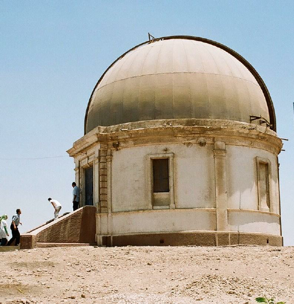
The Helwan Observatory was first used by Harold Knox-Shaw (1885–1970) to photograph Halley’s comet (1909-11). There was an early 30-inch (76cm) Reflector (1902/05) f/4.5, presented to the observatory by the amateur astronomer and Birmingham industrialist John Henry Reynolds (1874–1949). The climate of Egypt is very suitable for astronomical photography during the greater part of the year: at times the atmosphere is so clear that stars are seen to set suddenly behind the desert horizon.
It was the first large telescope in Africa. It was used for photographing nebulae, for classification of spiral galaxies, recording nebulae spectra, observing Halley’s comet (1909/10) and especially for the variable nebula NGC 6729 in Coronae Australis.
Comets like Neujmin, Grigg-Skjellerup, Forbes, Tempel’s, Peltier Whipple, Kaho, Peltier, Jackson, Brook’s, Wolf’s, Borrelly’s, Quenisset’s, Beljawsky’s and Mellish were regularly observed. After the launch of the first satellite in 1957, telescopes and stations have been installed at Helwan Observatory for tracking artificial satellites. In addition, a horizontal solar telescope was errected in 1957 with Coelostat and spectrograph for the observation of sunspots, faculae and protuberances.
Japanese Botanical Garden was created in 1917 in a park with a hill, a huge Buddha face carved out of a rock, a Japanese cottage and a flat area with a little bamboo forest and a big smiling Buddha statue but not many typical Japanese flowers or trees to be found. This abandoned garden is the only Japanese botanical garden in the Middle East.
Note that the Google Maps location is not correct placing the observatory in the middle of a highway. the correct location is at 29° 51′ 31″ N, long. 30° 15′ 5.5″ E, elevation 116m above sea level.
I took an Uber here for a minimal Uber fee and then for 800 EP cash to Dahshur, The driver climbed down into the pyramid.
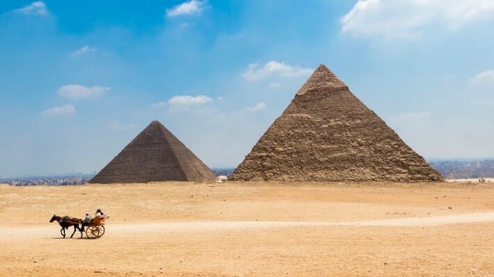
Royal Necropolis of Dahshur (01/11/1994) is a royal necropolis located in the desert on the west bank of the Nile approximately 40 kilometres (25 mi) south of Cairo. It is known chiefly for several pyramids, two of which are among the oldest, largest and best preserved in Egypt, built from 2613–2589 BC.
The Dahshur pyramids were an extremely important learning experience for the Egyptians. It provided them with the knowledge and know-how to transition from step-sided pyramids to smooth-sided pyramids.
The first of the Dahshur pyramids was the Bent Pyramid (2613–2589 BC), built under the rule of King Sneferu. The Bent Pyramid was the first attempt at building a smooth sided pyramid, but proved to be an unsuccessful build due to the miscalculations made on the structural weight that was being placed onto the soft ground (sand, gravel, and clay), which had a tendency to subside. The blocks weight was not distributed appropriately, causing the angle of the pyramid to be off and achieving the name “the Bent Pyramid”.
Realizing his shortcomings and learning from his mistakes, King Sneferu ordered the building of the second pyramid of Dahshur, the Red Pyramid. It was smooth sided, and a free standing pyramid rising to a height of 341 feet (104 meters), with an angle of 43 degrees. The Red Pyramid’s name reigns from the material that was used to construct the pyramid, red limestone. This pyramid is believed to be the resting place of King Sneferu.
The White Pyramid is that of the 12th Dynasty King Amenemhat II (1929–1895 BC). This pyramid has not been preserved as well.
The Black Pyramid dates from the later reign of Amenemhat III and, although badly eroded, it remains the most imposing monument at the site. The polished granite pyramidion or capstone of the Black Pyramid is on display in the main hall of the Egyptian Museum in Cairo.
From the parking area, climb up several steps to the entrance into the center of the pyramid. It is a steep descent while crouching over. Steel bars on the wood base provide braking power. Enter the first room with a high imposing corbelled roof. Climb some stairs and enter the second room, identical but larger. Repeat to exit. It is very hot and hard work with a strong smell of guano. 60 EP
I then took an Uber for 800 EP to Ramaya Square (near the Giza Pyramids) to get a minibus to Fayoum. This was another 800 EP. The drive through Giza must be one of the ugliest cities in the world – completely large apartment buildings (most around 12 stories and many unfinished). Ramaya Square is a huge minibus station. I found the next van to Fayoum quickly just before it filled so we had little to wait. I sat next to a nice guy, a civil engineer who helped me find a hotel in Fayoum.
ON Honey Day. 400 EP/night with breakfast. I withdrew more money, had a surprisingly good hamburger for dinner and then spent the rest of the evening trying to find a car (and driver) for the next day.
FAYOUM is a city in Middle Egypt 100 km southwest of Cairo, in the Faiyum Oasis, It is one of Egypt’s oldest cities due to its strategic location. Archaeological evidence dates it to the Epipalaeolithic and Neolithic eras. Habitation began in the fifth millennium BC and a settlement was established by the Old Kingdom (c. 2686–2181 BC) called Shedet (Medinet el-Fayyum). It was the most significant centre of the cult of the crocodile god Sobek and the Greeks called it “Crocodile City”. The city worshipped a tamed sacred crocodile.
Ptolemy II Philadelphus (309–246 BC) renamed the city Arsinoë and also established a town at the edge of Faiyum named Philadelphia. Under the Roman Empire and was called “Arsinoë in Arcadia”.
Today, Faiyum has several large bazaars, mosques, baths and a much-frequented weekly market. The canal called Bahr Yussef runs through the city with four waterwheels that were adopted as the symbol of Fayoum.
Oasis of Fayoum, hydraulic remains and ancient cultural landscapes (28/07/2003) is a depression or basin in the desert immediately to the west of the Nile, or just 62 miles south of Cairo, and is between 1,270 km2 (490 mi2) and 1,700 km2 (656 mi2). The basin floor comprises fields watered by a channel of the Nile, the Bahr Yussef, as it drains into a desert hollow to the west of the Nile Valley. The Bahr Yussef veers west through a narrow neck of land north of Ihnasya, between the archaeological sites of El Lahun and Gurob near Hawara; it then branches out, providing rich agricultural land in the Faiyum basin, draining into the large saltwater Lake Moeris (Birket Qarun).[1] In prehistory it was a freshwater lake, but is today a saltwater lake.[1] It is a source for tilapia and other fish for the local area.
Differing from typical oases, whose fertility depends on water obtained from springs, the cultivated land in the Faiyum is formed of Nile mud brought down by the Bahr Yussef, 24 km (15 miles) in length. Between the beginning of Bahr Yussef at El Lahun to its end at the city of Faiyum, several canals branch off to irrigate the Faiyum Governorate. The drainage water flows into Lake Moeris.
Lake of Qarun), is located in the Faiyum Oasis and has an abundant population of fish. In ancient times this lake was much larger.
The Oasis is the setting for about a quarter of Paolo Coelho’s The Alchemist, one of the top 20 best-selling books in the world.
Anisa Wissa Palace. The palace was constructed in 1898 on the orders of an Egyptian socialite, Hanna Saleh Nissim. It was built as a gift for his wife, Anisa Wissa, and named after her. The palace was constructed following an eclectic approach, combining Islamic and European architecture. The wood from France and Italy was used in the construction. The total area of the building is 4500 meters. The courtyard of the palace is decorated with Italian statues. The inside walls of the palace are ornamented, and the mirrors and marble fireplaces are heavily used in the palace.
Following the death of Wissa, her family the palace leased to the Egyptian government.
ON Honey Day. In the center of downtown, it is nice but quite cheap at 400 EP/night with breakfast.
Day 3 Dec 13. The hotel supplied breakfast delivered in a box to the lobby, with 3 cups of coffee.
I rented a car for the day to see the Lake Qaroun area for 2000 EP. There does not appear to be any car rental companies in Fayoum and I was dependent on the guy in the hotel to try to find a driver. We eventually went down to a small car showroom where they gabbed for an hour trying to find a driver. The prices increased from 1200 to 2000 to 2800 EP – “a 4Wd was necessary and there was a lot of traffic”. It was a lovely 2022 car but the driver spoke no English and was determined to not go where I wanted him to, but on a circuit of the tourist areas. Despite constant comments about how much traffic this was (and thus justifying the cost), there was very little. The roads were good except for the speed bumps, but deteriorated near Wadi Rayan where there were.
We drove NW from Fayoum to the north end of the lake and followed its entire east shore past Tunis Camp. It is a huge lake with the far shore barely visible through the hazy smog. There are many white birds, bullrushes lining the shore, gardens, palm trees, and olive groves.
Lake Qarun Protected Area (10/02/2003). Ancient lake in the northwest of the Faiyum Oasis, 80 km (50 mi) southwest of Cairo, Egypt. In prehistory, it was a freshwater lake, with an area of 1,270 km² – 1,700 km². It persists today as a smaller saltwater lake called Birket Qarun 43 m (140 ft) below sea-level and covers about 202 square kilometres. It is a source for tilapia.
The lake is first recorded from about 3000 BC and for the most part it would only be filled with high flood waters. The lake was bordered by neolithic settlements. In 2300 BC, the waterway from the Nile to the natural lake was widened and deepened to make a canal that now is known as the Bahr Yussef. The lake was eventually abandoned due to the nearest branch of the Nile shrinking from 230 BC.
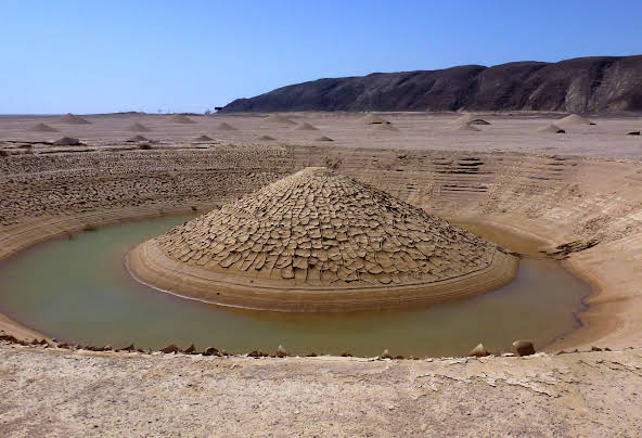
Wadi El-Rayan Protected Area. The valley of Wadi El-Rayan is 1759 km2, 113 km2 of which are the Wadi El Rayan man-made lakes 65 km southwest of Faiyum city and 80 km west of the Nile River. Wadi El Rayan Waterfalls between the two lakes are considered to be the largest waterfalls in Egypt (about 15 feet high and small.
Wadi El Rayan accommodates one of the world’s few remaining populations of the endangered slender-horned gazelle. 85 EP for Wadi Rayan and Lake Qaran Protected area. After paying the fee at the entrance to the park, the road turned into gravel, then rough pavement, and then new pavement (actively being done when I was there). It was featureless flat sand/dirt with no vegetation. We initially had a police escort.
The road to the waterfalls was moderately corrugated and he crawled along it at less than 5km/hour. Reach Masgic Lake, an artificial lake fed by a canal. The shore is a tourist trap lined with many open-air restaurants and souvenir shops in adobe buildings. The waterfall is a small fall in the main canal. There were buses of young people in the tourist area and in an area of a small sand dune/slope where they were using snowboards. Underwhelming at best.
Jabal El Medawara. Two small eroded hills with a flat top (a mountain in Egypt) to the side of Magic Lake. Many buses of young people walking a short distance to the top.

")
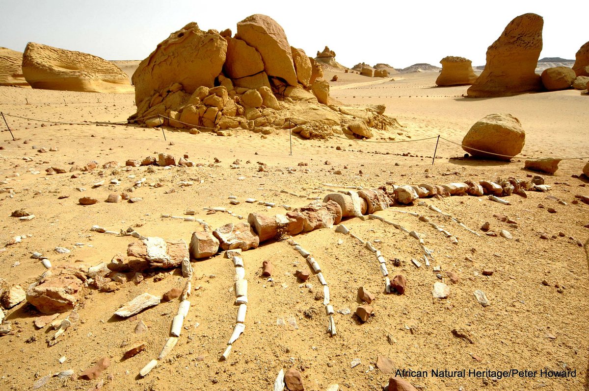
They say that visitors are restricted to prearranged guided tours but that is also total BS. Pay the fee and on your own, follow prescribed packed dirt trails between the main fossils eroded from the soft dirt. There is one main trail with small side trails to the individual fossils. Two small shelters have dioramas. It takes about 50 minutes to walk out and back and see 5 good skeletons sitting on top of the dirt. There are layers of black shale and mangrove roots – the whale fossils sit on top of the mangrove layer. This was a shallow sea called the Tethys Sea, part of the ancient Mediterranean that extended as far south as Luxor.
Four are of a small whale called Doridon that was thought to be the precursor of all present whales, porpoises, and dolphins. One is a large intact skeleton of a Basilosaurus, a much larger whale. Both were present about 38-40 million years ago and are both toothed.
Don’t miss the excellent museum with a 20 m long Basilosaurusm, many other skeletons of animals found here, displays on the evolution of whales, climate change, geology, and more. 250 EP.
Kom Aushim (Karanis), Dimai (Soknopaiounesos), Qasr Qarun (Dionysias), Batn I hrit (Theadelphia), Tentativ WHS (01/11/1994)
• Batn I hrit (Theadelphia). This is one of the more underwhelming ruins. Access is through an old garbage dump to see half of a hexagonal brick tower about 20 feet high. It appears that no one has been here for years.
• Byahma-Medinet el Fayoum. (Fayoum Water Wheels Park). Originally named Crocodilopolis, then Arsinoe, Medinet El-Fayoum was the main place of worship of the crocodile god, Sobek. Apparently, during ancient Medinet, crocodiles were adorned with gold and fed honey cakes and meat by the priests. Of interest are the huge wooden waterwheels. The waters of the Bahr Yusef are distributed throughout the oasis from Medinet, the capital of the Faiyum. Approximately 200 of the great waterwheels are located throughout the oasis. The Seven Waterwheels, a Fayoum landmark, are surrounded by mangos, palms, and willows. A great stone obelisk was erected in honor of Senwosret I in Abgig during the 12th Dynasty. It was discovered on the ground in two pieces during the 18th century and was recently reconstructed and erected in Medinet.
• Karanis. Kom Aushim Museum is located at the entrance of the Greaco-Roman town, Karanis. It consists of two floors and exhibits collections from the Prehistoric era to the Greco-Roman era as well as a collection from the Coptic and the Islamic era. The masterpiece of the museum is a Fayoum Mummy Portrait of a man. Labels are in Arabic and English.
• Soknopaiou Nesos was an ancient settlement in the Faiyum Oasis located a few kilometers north of Lake Qarun. The settlement – known nowadays as Dimeh es-Seba was an important religious center with an imposing temple dedicated to the god Soknopaios, an oracular god in the shape of a crocodile with a falcon head, from which the toponym of the town itself derived.
According to papyrological evidence, Soknopaiou Nesos was founded in the 3rd century BCE, during the land reclamation project of the Faiyum carried out by the first Ptolemies, and was abandoned in mid-3rd century CE. The archaeological evidence instead, releases new data about a late reoccupation of the site, concentrated especially inside the area of the main temple of the town, during the 4th-5th centuries until the end of the Byzantine period.
• Qasr Qarun (Dionysias). The ancient town of Dionysias was founded in the 3rd century BC. Dionysia was the start of the caravan route to the Bahariya oasis. There are the remains of Roman baths and villas.
The biggest attraction is the temple dedicated to the syncretic god Sobek-Ra with the features of the crocodile god Sobek and the solar deity, Ra. The building was built using large blocks of yellow limestone and is the only building that is almost completely preserved. Devoid of decorations, it looks from the outside like an uninteresting, square box. Inside, however, there is a real labyrinth of chambers, staircases, corridors, and tunnels arranged on different levels. There is a great view from the roof, as the yellow sands of the desert and the stony remains of the old city stretch to the horizon.
On December 21 each year, the sun illuminates the sanctuary Quds el-Aqdas (Holy Saints) inside the Qasr Qarun temple. This is called the sun alignment phenomenon.
I didn’t see the following:
Pyramid of Senusret II. The pyramid complex was constructed for the pharaoh Senusret II in the Twelfth Dynasty. Senusret II took a complete departure from the usual practice of having a corridor on the north side – typical of the Old Kingdom and early Middle Kingdom pyramids[2] – and had instead built a narrow, vertical entrance shaft under a princess’ tomb located about a dozen yards off to the east of the southern pyramid face.
Beni Souf, City
Meidum Archaeological Site. An archaeological site with a large pyramid and several mudbrick mastabas. The pyramid was Egypt’s first straight-sided one, but it partially collapsed in ancient times. The area is located around 100 km south of Cairo.
The second extension turned the original step pyramid design into a true pyramid by filling in the steps with limestone encasing. The outer layer was founded on the sand and not on rock and the outer surface was polished and this severely compromised the stability and is likely to have caused the collapse of the Meidum Pyramid in a downpour while the building was still under construction.
The Meidum Pyramid seems never to have been completed. In its ruined state, the structure is 213 feet high with the entrance in the north, 66 feet (20 meters) above present ground level. The steep descending passage 17 meters long leads to a horizontal passage, just below the original ground level, that then leads to a vertical shaft 10 feet (3.0 meters) high that leads to the corbelled burial chamber itself. The chamber is unlikely to have been used for any burial.
Dimeh Al-Siba (Dimeh of the Lions). On the northern side of Birkat Qarun, it was a Ptolemaic city believed to be founded by Ptolemy II in the third century BC, on a site that shows evidence of habitation from the Neolithic period. Today, it is more isolated, but during Ptolemaic times it was at the shore of the much larger lake, situated at the edge of Moeris Bay, and the beginning of the caravan routes into the Western Desert.

It was Ptolemy who reduced the size of the lake to provide land for the settlement of retired Macedonian soldiers and their families. The town served as a port and today, the site is 65 meters higher and 2.5 kilometers beyond the water’s edge.
During the troubles of the Roman Period, Dimeh reached its zenith and its ultimate decline. It was on the fringe of the desert away from the cultivated lands on the south side of the lake, so it was rather of a frontier outpost. Retired Roman soldiers preferred to live in the villages to the south like Philadelpha and Karanis.
Goods from the Fayoum were transported across the lake by boat to be unloaded at the docks of Dimeh, stored, or carried up the Avenue of the Lions, assessed for a customs fee, and reloaded on animals for desert caravans. These caravans moved north over Gebel Qatrani and probably via Wadi Natrun to the Mediterranean and on to Rome.
Here at Soknopiaou Nesos, as in other desert outposts in the Western and Eastern deserts, and along the northern coast, security systems were in place to protect caravans, but they did not always succeed. Dimeh was inhabited for six centuries and was finally abandoned by the middle of the third century AD.
The ruins of Dimeh al-Siba contain two temples, houses, underground chambers, streets, and ten-meter-high walls that are sometimes up to five meters thick. The walls themselves are a testament to the survivability of mudbrick in the desert environment. The ground is strewn with debris. An uncountable number of shards cover the entire temple mound. They are all over the place.
The city itself was spread out over a great distance through the desert, and the mudbrick walls that are still standing did not contain the entire town, but only the temple area. To the north were the agricultural fields, separated by long irrigation canals. To the south was the Gate of Soknopaios, at the end of the Avenue of the Lions, which ran down to the edge of the lake where the docks were located. Today, one can still see the remains of this road, which ends about a kilometer to the south of the ruins at a quay. The quay has two limestone piers and steps leading south, presumably to the water’s edge.
The following are significantly south of Fayoum:
Speos Artemidos (Temple of Pakht) is an archaeological site located about 2 km south of the Middle Kingdom tombs at Beni Hasan, and about 28 km south of Al Minya. Today, the site is a small village known as Istabl Antar.
There are two temples here, both of which are dedicated to Pakhet. They are cut out of the rock into the cliffs on the eastern side of the Nile. Cut from the living rock, Hatshepsut’s temple is composed of two chambers connected by a short passageway. Unfortunately, only three of the four columns forming the facade are still relatively intact and none of the internal pillars remain. The rock face above the external pillars of the portico is dressed and inscribed with text bearing Hatshesput’s name. It includes the famous text in which she denounces the Hyksos and records her actions in rebuilding the damage they had caused thus legitimizing her own reign.
Minia (01/11/1994). Located approximately 245 km (152 mi) south of Cairo on the western bank of the Nile River, which flows north through the city, Minya has one of the highest concentrations of Coptic Christians in Egypt (approximately 50% of the total population).
History. After the unification of Egypt, the provincial capital of the 16th Nome emerged as an important center of trade. It was opposite a trade route to the Red Sea along which the Levantine traders carrying their goods from Sinai and Canaan travelled.
Following the collapse of the Old Kingdom, and during the First Intermediate Period, rulers of Oryx became wealthy and powerful and enjoyed a certain degree of autonomy in relation to the central power of Pharaohs.
Like Pharaohs, rulers of the Oryx nome were deeply concerned with their lives after death. Because the pyramid-building age was over or maybe because they could not afford to construct their own pyramids, they chose the limestone cliffs of the eastern desert overlooking a gentle curve in the Nile as an ideal spot on which to carve their tombs. These chapel-tombs at Beni Hasan are the only remnant of the era. Today these thirty nine rock-cut tombs can be visited in the limestone cliffs above the modern day village of Beni Hasan.
Necropolises of Middle Egypt, from the Middle Empire to the Roman period. (28/07/2003). Cover about 2500 years
• Necropolises of Beni Hassan and Deir al-Barsha Two necropolises representative of nobiliary tombs of the Middle Empire (2064-1797) Tombs dug out of the limestone cliff, on a 100 m long terrace. 39 hypogeum, 12 tombs have paintings of long horizontal registers dealing with agricultural work, arts and crafts, and feudal military life.
• Amarna archaeological site (Akhetaten). From the New Empire (1543-1078), the remains of the capital city built by the Pharaoh Akhenaten starting in 1346 BC – reign 1348-1331 of the late Eighteenth Dynasty. It lasted for 17 years but had long-lasting consequences and left us with an astonishingly original legacy. Abandoned in 1332 BC shortly after his death.
Location: on the east bank of the Nile 58 km south of the city of al-Minya and 312 km (194 mi) south of Cairo and 402 km north of Luxor.. The region flourished from the Amarna Period up to the later Roman era.
Necropolis of Tell el Amarna
• Necropolis of Touna al-Gabal Have a combination of Greco-Roman and Egyptian art.
An extremely important religious centre from remote antiquity up to the Christian era, capital of the XVth nome of Upper Egypt.
• El-Eshmounein (Hermopolis) is at present an immense site with remains from various periods including a very beautiful Christian basilica from the Vth century AD dedicated to the Virgin.
==============================================================
RED SEA (Hurghada, Al-Qusair, Marsa Alam, Safaga) Dec 12-14, 2022
Day 4 Dec 14. I was up at 04:30, showered, had the hotel breakfast, caught a cab to the minibus stand, and then a bus to Hurghada on the Red Sea. I took the bus from Fayoum, 6 hours to Hurghada (250 EP), and stayed at the 4 Seasons Hotel, a low-end hotel converted into a hostel but with all private rooms with ensuites. 300 EP/night, a great deal. It is in downtown Hurghada, close to the water.
HURGHADA (pop 248,000). One of the country’s main tourist centres located on the Red Sea coast owing to its dramatic landscape, year-round dry and temperate climate and long stretches of natural beaches. Its waters are clear and calm for most of the year. Founded in 1905, it was a small fishing village, but it has grown into a major Red Sea holiday destination for Europeans starting in the 1980s. The city is known for its watersports (windsurfing, kitesurfing, yachting, scuba diving, and snorkeling), nightlife and warm weather. Daytime temperatures are around 30 °C most of the year (July and August over 40 °C). Tourist numbers from Russia dropped significantly after the Metrojet Flight 9268 plane crash in November 2015.
The city extends for about 36 kilometres (22 mi) along the coast, but does not reach far into the surrounding desert. Dive sites around Abu Ramada Island, Fanadir, Giftun Kebir, and Giftun Soraya are popular. Tourists also visit shipwrecks such as the El Mina or the Rosalie Moller. In a 2016 attack and again in a 2017 attack foreign tourists at Hurghada’s beach resorts were targeted by terrorist attacks.
Russians. Hurghada has 4 schools for Russian children, and much of the signage in the city is in Russian. In 2015 there were about 20,000 Russians in Hurghada. Russian women staying in Hurghada often marry Egyptian men through an ‘urfi (non-shariah) process.
I took a share van from the van stand to Sand City. The aquarium is near and then a share taxi into Harghada to the mosque.
Sand City Hurghada. In the NM Bizzarium series, this was produced in 2013 by 35 artists from 13 countries. 5,000 m of water and 35,000 m of different coloured sand were used. It is divided into two parts: historical figures (with very good biographies) and a kid’s section of cartoon characters. Hurghada is the ideal place for this as it rains so rarely, about once a year at most. Despite that, some of the structures have fallen down and repairs are necessary.
I thought it was actually worth the high entrance fee of 10€.
Go to the south end of the strip mall and walk down the gravel road then veer left to the entrance.
Hurghada Grand Aquarium. This is a huge, extravagant aquarium with 24 galleries holding 1 million gallons of water, one of the largest aquariums in the world. The Ocean Tank has a lovely underwater walk. 32€
Al Mina Mosque. An extravagant mosque with many intricate designs – 2 minarets and about 15 exterior domes. Inside is one large dome with a huge chandelier.
EL GOUNA. About 25km north of Hurghada, this is a very up-scale tourist city of hundreds of high-end resorts, condominiums, manicured boulevards, many indented bays with marinas and yachts, and high-end stores and restaurants. Dating from 1989, it has 10 kilometers of coastline and consists of 20 islands surrounded by lagoons. El Gouna buildings were designed to resemble traditional rural Egyptian architecture such as that found in the Egyptian countryside and in Nubian villages. El Gouna specializes in water sports.
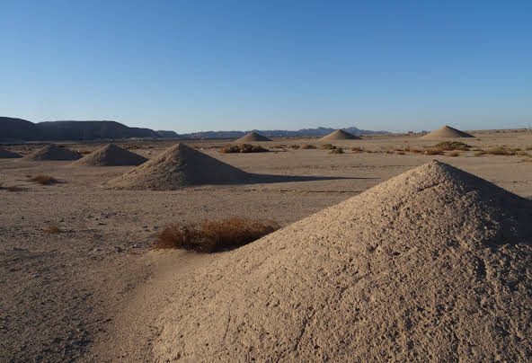
Desert Breath. In the NM Bizzarium series, this is a double-spiral work of land art. It was created by the D.A.ST. Arteam, a group made up of three Greek artists in 1997, covers an area of about 10 hectares (25 acres). It consists of 89 protruding cones of gradually increasing size set in a spiral and another 89 depressed (incised) cones set in spirals. The sand dug out from the depressed cones was used to create the protruding cones, resulting in the displacement of 8000 cubic meters (10500 cubic yards) of sand. At the center of the art piece used to be a body of water 30 meters (98 feet) in diameter which has since evaporated. The artwork is subject to natural erosion and in due course, the area will revert to the original desert plain. It is viewable by satellite pictures via Google Earth.
The artists have stated that the project was meant to suggest an experience of infinity with the desert as a landscape of the mind. Even though it is in a state of slow disintegration, Desert Breath is still viewable two decades after its creation. Through its slow disintegration, the installation has been seen as an instrument to measure the passage of time.
I took a bus to the El Gouna turn-off and then an Uber about 5 km north along the main north-south highway. I had not read about it and not understanding, found it underwhelming. It is in the middle of nowhere next to the highway and appears to be many perfectly conical mounds of grey sand. It is not eroding but has many weeds and the lake is of course gone. From the ground, the spiral shape is not so obvious. I thought I had come to the wrong place. (coordinates: 27°22’54.59″N, 33°37’48.46″E)

 The Uber then took me to El Gouna. A passport is required to enter at the highway gate. Then it is about 12 km to the beach next door to Moods Restaurant.
El Gouna Beaches. There are several beaches including Zeytuna Beach located on its own island, Mangroovy Beach, Moods Beach, and other hotel beaches. I visited Moods Beach fronting two large resorts. The sand was manicured and there were many beach recliners with umbrellas, round beach loungers with grass roofs, and weathered white folks.
El Gouna Aquarium. This small aquarium is hard to find. It is on an inside island. The displays are small and show Red Sea creatures. 5€ I walked 2.5 km from the beach to the aquarium and the Go Bus stand. 20 EP back to Hurghada.
Day 5 Sun Dec 13. After two nights in Hurghada, I took a Go-Bus to Luxor.
I didn’t see the following
Sharm El Naga beach. Near Soma, it is 70 km south of Hurghada.
Soma
MARSA ALAM*. Town in south-eastern Egypt, located on the western shore of the Red Sea. It is a popular tourist destination. Beaches: Abu Dabab beach, turtles are common, crocodilefish and octopuses. Marsa Alam is also known as a world-class kitesurfing destination and the perfect starting point for safaris. Marsa Alam also has some inland attractions, such as the Emerald Mines and the Temple of Seti I at Khanais.
Despite being over 135 miles (217 km) km north of the tropical zone, the city experiences a hot desert climate. The temperature of the Red Sea at this location during the year ranges from 22 to 29 °C (72 to 84 °F).
DIVING: The Red Sea resorts at Sinai peninsula, including Sharm El Sheikh and Ras Mohammed, diving in The Gubal Strait, the wrecks at the Strait of Tiran, reef diving in Hurghada and Marsa Alam, the Abu Nuhas wreck system, and pelagic encounters at Brother Islands, Dahab. Shallow reefs, walls, drift dives, coral gardens and some of the most famous wrecks in the world in crystal clear waters. Many species of sharks.
It is possible to dive all year round. However the water temperature does vary a lot: From July to September, it is the hottest month with a water temperature of about 28°C. The coldest month is February with a water temperature of about 21°C.
From October to November, you can expect from 25°C to 27°C. From March to June, the water is warming up with temperatures ranging between 22°C to 25°C.
There is not really one single “best diving season” in the Red Sea but if you don’t like crowded dive sites, try to avoid the high season from July to December. If you do go during the busy period, you should book your hotel well in advance.
Bird Migration Routes. Tentative WHS (12/06/2003).
Bardawil Lake is on the coast, has an area of about 59,000 ha, and is a Ramsar Site. It consists of two interconnected hypersaline lagoons, with interspersed islands and peninsulas. The site provides important spawning areas for fish and supports commercially important fish stock, mainly the mullet. It is also an important wintering and staging area for about half a million birds in 244 bird species, 18 reptiles.
Salt extraction and the constant formation of sand bars (siltation) close the channels connecting the lagoons with the Sea. These channels are vital for the annual migration of mullets from the Sea to the Lake and vice versa. The El-Salam irrigation Canal, bringing water from the Nile mixed with agricultural drainage water from the eastern Delta pollutes the Lake
Zaranik Scrubland. Migration and wetland hotspot east of Lake Bardawil about 35 km west of El-Arish,. The site consists of a lagoon, beach, and desert scrub vegetation (68% water and 32% land). It is an excellent site for autumn migrants.
Gebel Shayeb El-Banat. Near Hurghada, it comprises four mountains: Gebel Abu Dukhan (1705 masl), Gebel Qattar, Gebel Shayeb El-Banat (the highest peak in the Red Sea coastal mountains), and Gebel Umm Anab.
The shoreline is a chain of coral reefs up to 100 m wide.
Ma’aza tribe, known as Bani Attia (pop 1000) living in an area of 90,000 sq. km. They are pastoral nomads, raising sheep, goats, and camels with no fixed dwellings.
Saluga and Ghazal Nile Islands Granitic outcrops of fine grained granite. The 94 species of vegetation is the relicts of a Nile Valley gallery forest. Trees of six species of Acacia dominate the plant communities
Lake Nasser is A huge man-made water reservoir extending 300 km upstream of the Aswan High Dam in Egypt and continues as Lake Nubia for another 200 km in Sudan. It has an average width of 10 km. On completion of the construction of the High Dam in the early 1970s, the Lake covered the entire Nubian Nile Valley in both Egypt and Sudan and deeply penetrated into the surrounding desert through the numerous wadis (dry desert rivers) that drained from the Eastern (the majority) and the Western Deserts, about 80 all in all, the largest of them being Wadi Allaqi. This gives the Lake its dendritic shape in satellite images. The climate is extremely arid with very hot summers and cold winters.
A yearly fluctuation of as much as 30 m and large wetlands have formed in the deltaic mouths of the dry wadis where they join the Lake. It is increasingly important as a wintering area for migratory Palaearctic water birds. Important Bird Areas of Egypt especially water birds (herons, ducks, waders, and terns).
Mountain Chains. Tentative WHS (12/06/2003).
Yelleg, Halal, and Maghara Mountains Yelleg (1087 m), Halal (892 m), and Maghara (750 m), are isolated highlands with the only conifer tree in Egypt, Juniperus phoenicia, 200 species of vascular plants including a rare assemblage of rare, vulnerable, and threatened species
Gebel Dokhkhan See Gebel Shayeb El-Banat Site
Gebel Elba region in the south-eastern corner of Egypt lies adjacent to the border of Sudan, and the Red Sea. Average annual rainfall is 50 mm/year, but moist north-easterly winds bring as much as 400 mm. This creates “mountain oases”, or “mist oases” on the slopes of these mountains. Habitat types include Red Sea coral reefs, Mangroves, Low shore-line coastal dunes, Littoral salt marsh belts.
Many species are threatened with extinction: African wild ass, the addax antelope, the Tora red hartebeest, the dama gazelle, and the scimitar-horned oryx.
The traditional home of several hundred nomadic Bisharin tribesmen, whose language and some of their traditions can be traced to the Ancient Egyptian language and traditions.
Gebel Oweinat Region Formidable mountain in the centre of the flat and featureless Western Desert of Egypt and it stands out like an island from the surrounding plain. The last rainfall was seen in September 1998 and as much as 10 to 15 years may pass without a drop. Yet this little rain is sufficient to allow vegetation and some wildlife to survive.
The western part lies entirely in Libya and forms a large granite ring complex about 25 km in diameter, being the eroded remnants of a large archaic granite dome. Two permanent springs, Ain Ghazal and Ain Doua, can be found at the southern foot and have never gone dry in living memory. A heavily used desert track passes by along the western rim of the Mountain, linking Kufra with El-Fasher in western Sudan. Site
The Gilf El-Kebir Plateau. A landscape similar to Mars and one of the driest regions of the Earth. Remote and not yet been fully explored. It is a high, flat-topped plateau (a few basalt flows) of Nubia sandstone covered with a thick red soil with vertical escarpments on all sides, 200 to 300 m above the surrounding desert. It is dissected by numerous canyon-like dry wadis. The soil indicates heavy rainfall in older times.
OTHER DESTINATIONS
Bir Tawil. M@P
Hala’ib Triangle. Egypt/Sudan – M@P, XL
El Ikhwa island
Shadwan Island
Foul Bay area, XL
Wadi el Gemal NP
Brothers Islands Lighthouse
