
Ethiopia – Dec 21-Jan 7, 2023
Ethiopia is a landlocked country in the Horn of Africa. It shares borders with Eritrea to the north, Djibouti to the northeast, Somalia to the east and northeast, Kenya to the south, South Sudan to the west, and Sudan to the northwest. Ethiopia has a total area of 1,100,000 square kilometres (420,000 square miles). Addis Ababa lies several kilometres west of the East African Rift that splits the country into the African and Somali tectonic plates.
Ethiopia is the oldest independent country in Africa and the second-oldest official Christian nation in the world after Armenia. Ethiopia is also the place for the first Hijrah (615 AD) in Islamic history where the Christian king of Ethiopia accepted Muslim refugees from Mecca sent by the prophet Mohamed. Along with Liberia and Darwiish State, it was the only nation to survive the Scramble for Africa, until it was occupied by Italy and annexed to the colony of Italian East Africa, alongside Eritrea and Somalia. It was liberated during World War II and later involved in wars against Oromo and Somali rebels and the newly annexed Eritrea, whose independence led Ethiopia to return to being a landlocked country.
Ethiopia is a multi-ethnic state with over 80 different ethnic groups. Christianity is the most widely professed faith in the country, with significant minorities of Islam and a small percentage of traditional faiths.
Ethiopia is considered an emerging power and developing country, having the fastest economic growth in Sub-Saharan African countries because of foreign direct investment in the expansion of agricultural and manufacturing industries. However, in terms of per capita income and the Human Development Index, the country is regarded as poor with high rates of poverty, poor respect for human rights, and a literacy rate of only 49%. Agriculture is the largest economic sector in Ethiopia, accounting for 36% of the country’s gross domestic product as of 2020.
The people are beautiful, with dozens of cultures but one of the worst for begging and annoyances. Viewed as a walking lottery ticket, they follow you, begging for money and shouting, “you you you! money money money”
Capital. Addis Ababa
Area1,127,127km² Water: 7,444km², Land: 1,119,683km²
Population. 113.5 million (2nd in Africa)
Language. Amharic (official), Oromo, Tigrinya Guaragigna, Somali, Arabic, other local languages, English (major foreign language taught in schools)
Religion. Ethiopian Orthodox, Protestantism, Catholicism, Islam, Judaism, Animism, Baha’i
Country code+251
Electrical Plug. European 2-prong
Visa. Virtually all but local countries need a visa obtained as an e-visa. The VOA was suspended in Oct 2022. It is available only as single entry 30-day and 90-day. It takes 2-3 days to obtain and is received by email. At immigration, get a stamp, not a full-page visa.
Money. Ethiopian Birr ETB. 1 US$ = 53.54; 1 € = 56.9; 1 CAD = 39.38 (xe.com Dec 2022)
ATMs work well at the airport and in cities. Because of inflation, withdraw relatively small amounts. Ethiopia hoards US dollars and financial institutions it’s illegal to give any out. May get some at the National Bank of Ethiopia, providing proof of future departure and hours of endless paperwork.
Ethiopia is a black market money country but this is not well advertised, illegal and people are arrested for doing it. If you withdraw money from an ATM, you immediately lose the difference between the official and black market rates.
Buy birr at 64-70/US$ at the airport and 80-90 birr/US$ on the street (if you can find someone or have a friend with connections). Buy US$ at 110 birr/US$.
At the Lalibala Stone churches, where the entry ticket is US$50, they had only euros which they wouldn’t accept. A guide working in the office offered to exchange it for me. I got 57 EB for it but he exchanged it on the black market and made 2,100 birr, a nice profit of $40. He wouldn’t share.
Getting a vehicle into Ethiopia
Crossing the border into Ethiopia from Sudan or Kenya since October 2022 has become impossible as Ethiopia has stopped the Temporary Import Permit system and now requires paying a new import tax per vehicle of varying amounts of US$ 25,000 to $82,000 to $100,00 or 500% tax on the value of the vehicle (even old cars). It will not be refunded. Motor vehicles such as cars and motorcycles have to pay. Bicycles without motors pay or are fined $40 or around 2,000 Birr. Electric vehicles do not pay. The traveller writing the post had bought in Egypt a ’02 inline 4-cylinder diesel Mitsubishi Pajero.
The Ethiopian Customs Commission (ECC ) decided to implement this law to restrict the illegal selling of vehicles by “wealthy” Ethiopians who drive cars to Ethiopia as tourists under a temporary import permit (free), sell the cars, and make a killing because cars are 2-3 times the value here. Officially, the law is temporary, but how temporary is anyone’s guess?
A CDP doesn’t work.
Workarounds:
1. People are trying to ship their vehicles from or to any East African port to Saudi Arabia – a ferry from Port Sudan to Jeddah to ship by container to Mombasa. Cost €3600 all charges included.
2. The Ministry of Tourism may allow you to work with a local tour operator to give letters granting passage to pass through each region to customs. The local tour operator is responsible for the vehicle, thus waiving the payment. Start with a letter from the Ethiopian Tour Guides. Paying a tour guide cost depends on where you go and what you barter but $150 to $40/day for the guide/tour agency for taking responsibility of the car. To see more of Ethiopia it would be 12-15 days or around $1200-1500.
OBSERVATIONS on ETHIOPIA
1. People. Ethiopians are different-looking Africans – small, finer-boned, not many tall people, chocolate colouring, narrow faces with narrow noses, women have small bums, little or no obesity. Women don’t use attachments, false eyelashes or long fingernails. It would appear that Ethiopian hair doesn’t have as much curl as many women have straight hairstyles. There is a lot of poverty in Addis Ababa – homeless, more begging than anywhere else I have ever travelled (elderly, women with babies, children as young as 2, guys wanting cigarettes). Many have their hand out;”Give X”.
2. Cost. Relatively cheap. The hostel I am staying in is $8 for a dorm room, and $12 for a private but with no BF. Food is inexpensive.
3. Food. Small coffee shops are next to the sidewalk everywhere. Small charcoal braziers heat coffee in tall pots and serve it in tiny cups. Sugar but not milk is offered. Hamburgers and pizza are available but there are no fast-food chains. Many food venues are tiny and there are few large restaurants. Large food stores are rare, most are tiny shops with a counter and the seller gets your product. Milk is only available in 1/2 litre plastic bags or powdered and no UHT milk in cartons. If alone, menus are hard to navigate as there are no descriptions and some are only in Amharic.
4. Stores. There are no large shopping malls. AA has two large markets typical of African markets with few products of interest to foreigners. Mercato is pure bedlam and stretches for blocks – finding the actual market is confusing. Products are sold all together – one area for shoes, women’s clothing, housewear, jewelry, carpet, luggage, and drapery.
Clothing stores have a huge number of mannikens outside.
5. Transportation. Besides taxis, most locals travel in cheap share vans (10-30 cents per ride depending on distance. They travel fixed routes – I follow Google Maps and get off when they turn off your route and then find another van. Sometimes rides last a few hundred yards, sometimes 5+ km. Unlike other places, they congregate at turn-around points – take the front van as they leave only when full and they cram people in.
I haven’t been able to figure out the buses and didn’t take one. I walk a lot.
Domestic flights are the cheapest in the world and are heavily used by the locals as distances are big and roads are not always very good. If you fly into or out of the country, Ethiopian Airlines flights are 50% off the already very cheap fares.
6. Traveling with Chinese tourists. Chinese are the most disliked tourists. I had no previous experience but had a group of six join us for the tour to the Afar.
a. Social. They are not socially competent people and never initiate conversation. You can ask them many questions but they rarely show any interest in you. If a group, they sit together, speak Mandarin and don’t participate with other tourists.
b. Photos. We were at one of the most marvelous natural attractions in Ethiopia in the world but it became almost impossible for anyone to take a picture of it without having a Chinese posing in the photo. There were 3 groups of two and each took many photos of the other trading places. It took forever for them to clear. I asked if they could allow some of us to take photos, and they got irritated and said “We have all day, we don’t have to be at the volcano till 8 pm”. We had limited time with an onerous drive and started hiking at 5:30.
c. Food. When your food arrives, be early as they pay no attention to the needs of others and fill their plates.
ETHIOPIA – ADDIS ABABA
Day 1 Wed Dec 20
Flight: Ethiopian Airlines Khartoum to Addis Ababa KRT-ADD 11:25-14:30.
I arrived, used an ATM to withdraw money and bought an Ethio-Telecom SIM with unlimited data for 1 month for 1050 birr ~$21 (relatively expensive). It was advertised that there were mini-buses from the airport, but there were only taxis. I ended up walking about 1 km to find share vans near my hostel then walked.
ON Mad Vervet Hostel. The only hostel in Addis was cheap at $8 for a dorm room and $12 for a private. The rooms were perfectly adequate but we had no water most of the time. They arrange tours to Afar and Omo.
ADDIS ABABA
Day 2 Thur Dec 21. I used share vans (5-15 birr) and walked to see the following.
Shola Market. A huge market under corrugated roofs. Everything is in sections – shoes, clothing and a small produce section. All local goods are of not much interest to a foreigner.
Lion Park. In the Anbessa Gibi Park are lions, various apes like gorillas, and birds like eagles, but it is very depressing as the animals appear ill. 100 EP
Yekatit 12 Monument. In a roundabout, this is an obelisk with several metal statues. It commemorates victims of Italian reprisals following an attempt to kill Marshal Rodolfo Graziani, marchese di Neghelli, Viceroy of Italian East Africa, on 19 February 1937, or Yekatit 12 in the Ethiopian calendar. It is located in the centre of Sidist Kilo (Amharic, “Six Kilometre”) Square, also called “Yekatit 12 Square”.
Ethnological Museum. In Haile Selasse’s former palace, it has an eclectic collection on two floors. Labelling is erratic. Visit H.S” apartment with a turquoise blue bathroom. 200 EP
St. George’s Cathedral. Ethiopian Orthodox, octagonal in shape, and a central altar area under a big dome surrounded by two corridors. I waited an hour for it to open at 2 pm. Many devotees kissed the gates and walls and prayed. Inside there was a lot of incense and people wearing shawls.
The new church was built on the ruins of an older church from the 15th century. It was named after St. George after the Tabot (Ark) of the church was carried to the Battle of Adwa against the Italians during which the Ethiopians secured victory. The Italian Fascist authorities set the building on fire in 1937. The cathedral was later restored by Emperor Haile Selassie following the liberation in 1941.
Empress Zewditu was crowned at this Cathedral in 1917, and Emperor Haile Selassie was crowned there in 1930, and it became a pilgrimage site for Rastafarians. The Cathedral has a museum, and an Imperial throne is on display as are the stained glass works of artist Afewerk Tekle. Given the reason why the cathedral was named, it displays weaponry used in the wars against the Italians including curved swords and tridents and giant helmets made from the manes of lions.
The Africa Unbound Museum. A private museum developed by a lovely woman, it presents a humanitarian view of the world. All in English and seen with a guide. Have a coffee on the veranda where I talked with the owner. 400 SP
Derg Monument (Tiglachin monument), is a massive, 50 m tall triangular monument with a Soviet star on top and a gold hammer and sickle crest.
Monument to the Lion of Judah. In a triangular roundabout, a lion with a crown and a Coptic lance sits on a stone plinth.
Meskel Square. A large half-oval square lined with bleachers at the back. The square itself is empty.
Red Terror Martyrs Memorial Museum. In the NM The Dark Side series, it was established in 2010 as a memorial to those who died during the Red Terror under the Derg government. The museum has displays of torture instruments, skulls and bones, coffins, bloody clothes and photographs of victims. In free tours of the museum, guides show the history leading up to the Red Terror (starting from Haile Selassie’s 80th birthday celebration), the actions taken toward citizens who opposed the Derg, how the prisoners were treated and how they secretly communicated among each other.
The Ethiopian Red Terror was a violent political repression campaign of the Derg against other competing Marxist-Leninist groups in Ethiopia and present-day Eritrea from 1976 to 1978. The Qey Shibir was an attempt to consolidate Derg rule during the political instability after their overthrow of Emperor Haile Selassie in 1974 and the subsequent Ethiopian Civil War. The Qey Shibir was based on the Red Terror of the Russian Civil War, and most visibly took place after Mengistu Haile Mariam became chairman of the Derg on 3 February 1977. It is estimated that 10,000 to 750,000 people were killed for the Qey Shibir. In 2007 and 2008, Mengistu was convicted in absentia by Ethiopia for his role in the Qey Shibir while leader of the Derg.
Day 3 Fri Dec 22
I had another walk about today trying to see some of the accessible sites I had missed on my first day.
Medhane Alem Cathedral. This large church has a big dome and iconoclast covered in frescoes. The stained glass is not stained but coloured and fading with the sun. Again there was a heavy smell of incense, people kissing the walls and many reading their Bibles in the church. They are a devout bunch.
Merkato Market. It’s hard to know where this starts and ends as there is an active market for blocks around, a mess of trucks unloading stuff, human mules carrying impossibly large loads and a lot of people. The market I was directed to has stores opening onto the streets. The goods are only of interest to the locals.
There were two long share van rides to here. Then I walked to the museum, cathedral, palace and down to Meskel Square where I got a share van to within a km of my hostel. This was another big walking day.
National Museum of Ethiopia. The basement has one of the best descriptions of the evolution of Homo sapiens. It all started about 7 million years ago with bipedalism that allowed them to come out of trees. Of course there is much on Lucy and the many other sapiens precursors mostly in Ethiopia, but also throughout Africa. The first floor has national costumes and some ethnography. A well-done museum. 50 EP
Holy Trinity Cathedral. The entire front steps had a ceremony happening with guys in gold and white robes under umbrellas so the church could not be entered. Surprisingly this church charged an entrance fee of 300 EP.
Unity Park. Unity Park is located in the premises of the Grand Palace and it is composed of various historical, natural and cultural sites. The Grand Palace was established in 1887 and has served as the living and working space of seven Ethiopian leaders. The palace covers an area of 40 hectares and contains myriads of historical buildings and plants that date back to the time of Emperor Menelik II. The palace can’t be visited.
==============================================================
Day 4 Sat Dec 24
ETHIOPIA – AFAR (Semera)
Borders: Djibouti-Ethiopia, Eritrea-Ethiopia
Up at 04:30, we got a taxi at 5 to the airport. I had arranged a 3-day tour through the hostel for $450.
Flight: Ethiopian Air: ADD – SZE 07:00 – 09:00. 65$
We were met by our tour operator and taken to their compound for brunch and coffee. Then with 9 others, piled into four Land Cruisers for the 300km, 6-hour drive. The other tourists were Britto (an Indian from Kerala working in fintech in Germany, Orim, an Indian from Chennai working in IT in Kigali Rwanda, and Dennis, from Kenya in our car: a Ukranian living in Belarus and an Ethiopian actor living in Addis. The other 6 were Chinese, three living in Nairobi, one in Barcelona and a man living in Salt Lake with his mother from Beijing. Initially flat r0cky desert with dead grass (in the dry season), we eventually went through land covered with basalt volcanic fields. We passed many camels and tiny settlements of locals with domes and homes with a wood frame covered with tarps and burlap. Small wattle enclosures were for their goats. Several round cairns of rock were common. A high range of rock mountains was on our right.
The long drive went through an amazing variety of terrain initially on good pavement, then a concrete highway constructed by the Chinese to access the salt. The concrete ended just past a cement plant (with Chinese characters) and we entered an area of ah-ah lava – very rough broken ground and slow going for about 20 km. The road started again on an incredible raised bed with intermittent constructed cement culverts. The cement roadbed was intermittent with one lane finished, occasionally two lanes and often detours around areas of construction. There were immense lava fields most pua-pua lava. A few mountains were in the distance. We stopped at an area of sand and the wind blew the sand covering everything. It was a mistake to get out as we were immediately covered in the fine grit. Then there was an immense flat with many braided roads and fast driving.
We eventually reached an Afar village where we spent the night. The homes were constructed of rough thin poles draped with nylon tarps and very rough. The Afar are very thin-faced people. It was hard to imagine what their existence was – a few goats, camels, and not much else. On the way, small groups seemed to appear out of nowhere. Dinner was tea, a soup with small pasta and vegetables and pasta (not very satisfying. The information from our guide was zero.
We slept on wood bed frames and mattresses. I was very comfortable with my silk sleep sheet and bag but it was warm most of the night.
Day 5 Sun Dec 25
On one of my unusual Christmas days, we were up at 5 for a BF of Cream of Wheat, scrambled eggs and tea. Then we drove north towards Eritrea, to an immense salt flat in an area called Dallol. Initially hard crystalline, we stopped at the edge of the water covering the salt about 1-2″ deep.
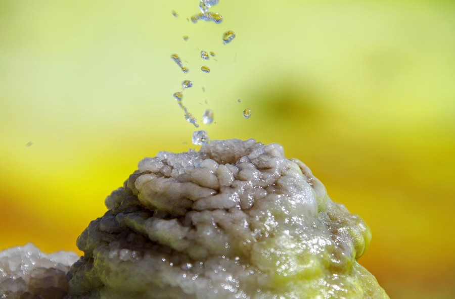
We then continued to drive over the huge plain, white changed to brown with many heaves in small concentric areas and arrived at the main attraction, a dome of active volcanic action. We climbed gently up to a large flat area with salt pools coloured bright yellow from the sulphur and brown from iron, bubbling water through tiny salt domes and areas of bright yellow sulphur “flowers”.
Dallol is a unique terrestrial hydrothermal System around a cinder cone of a volcano in the Danakil Depression known for its unearthly colours, mineral patterns and very acidic fluids that discharge from its hydrothermal springs.

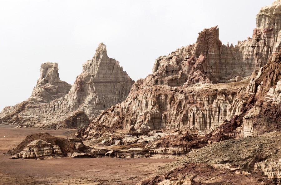
Nearby are a large area of limestone cliffs eroded into spires and cliffs.
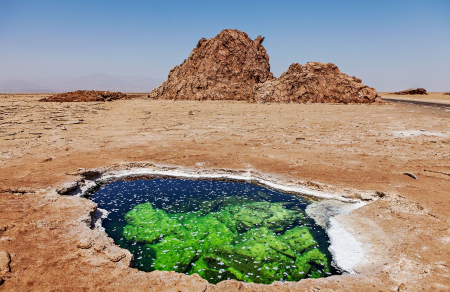
Continuing back, we stopped at an open pool in the plain of clear water less than a foot below the surface. Several dangled their feet in the water. Water underlies the entire plain.
We then went past an area where the Afar were mining salt. They were at the edge of a huge area previously mined because there was a layer of dirt/salt where large blocks could be lifted out. Guys using precision axe work cut it into uniform blocks then other guys dress the blocks by cutting off the dirt bottom and top and cutting the blocks into more precision rectangles. There must have been about 300 working in the area. The salt was carried away in large trucks taking in back all the way we had traversed yesterday. Now we know why they have remained in this inhospitable place.
After a long lunch at the Afar town where we slept, we started for Erta Ale volcano driving back through all the terrible roads through the volcano fields. We rejoined the good road briefly and then took a narrow through the lava about 15 km to a camp under the volcano. It was a 30-minute walk starting at 17:30 to the crater rim on a rough hiker-made trail. At the top are many rock buildings (that we were supposed to be sleeping in). Below is a huge crater with no visible activity. Drop down into the crater on a rough trail and walk across the crater to a caldera with two active sites. One is a large cone with great red fire. The other is off to the left and not as dramatic. It was pitch black at this time and we walked back in the night, impossible without a torch. The last significant activity was
We had dinner and slept on mattresses on the ground. It was considerably colder and windy but I was comfortable with my sleeping bag and sheet.
Day 6 Mon Dec 26
The Chinese left early and six of us continued back to Semara.
ON A great hotel for 600 birr, clean, strong A/C and very good food.
I caught a flight to Lalibela via Addis.
Lower Valley of the Awash WHS. The Awash Valley contains one of the most important groupings of palaeontological sites on the African continent.
The Lower Awash Valley paleo-anthropological site is located 300 km northeast of Addis Ababa, in the west of the Afar Depression. It covers an area of around 150 km2.
The Awash Valley contains one of the most important groupings of paleontological sites on the African continent. The remains found at the property, the oldest of which date back over 4 million years, provide evidence of human evolution, which has modified our conception of the history of humankind. The most spectacular discovery came in 1974 when 52 fragments of a skeleton enabled the famous Lucy to be reconstructed.
Excavations by an international team of paleontologists and pre-historians began in 1973 continued annually until 1976, and ended in 1980. During that time, they found many fossilized hominids and animal bones in a remarkable state of preservation, the most ancient of which were at least four million years old. In 1974, the valley produced the most complete set of remains of a hominid skeleton, Australopithecus afarensis, nicknamed ‘Lucy’, dating back 3.2 million years. Afarensis has since been proven to be the ancestral origin for both Genus Australopithecus and Homo sapiens.
A recovered female skeleton nicknamed ‘Ardi’ is 4.4 million years old, some 1.2 million years older than the skeleton of Australopithecus afarensis ‘Lucy’.
There is a wealth of paleo-anthropological and pre-historic tools still awaiting discovery and scientific study and these are seen as constituting an exceptionally important cultural heritage resource.
The site is called “Hadar” and is situated south of the Danakil depression around 2-3 hours dirt road drive north of the Awash- Djibouti road near the new regional capital of Semera. It is “normal” to visit it as part of a 4×4 expedition into the Danakil or as a “diversion” on the way back from Lalibela to Addis.
Permission is needed from the Afar Regional State Tourism Commission in Semera. Entrance is 50 birr per foreigner (c US$5) and a guide must be taken. This area is tribal and the sensibilities of the locals have to be assuaged by local involvement in the form of a guide at least.
What will you see? The site is surrounded by a fence marked by the UNESCO logo. Universities are still digging in the region. You see several “depressions” where digs have previously taken place and the location where “Lucy” was found is marked. And that seemed to be about it.
Seeing it requires a diversion that takes 2 extra days and an 800 km return. Just to see a few holes in the ground and a UNESCO sign?
The remains of “Lucy” are normally kept in a museum in Addis but are currently, and very controversially, on tour in the USA for several years. The tour would earn his country $25 million.
Another early hominid site at Melka Kunture (near the WHS of Tiya) has a fine museum that covers both the specific site as well as placing all the Rift Valley hominid sites in context, including Lower Awash (Hadar) and Omo. Melka Kunture is not currently on Ethiopia’s Tentative List. It would seem so much better to link the Omo and Awash as well as Olduvai (and possibly other sites such as Turkana) into a single multi-national site “Early Hominid sites of the African Rift Valley”.
==============================================================
ETHIOPIA – AMHARA EAST (Lalibela, Dessie)
Flight Ethiopian ADD-LLI @10:00 – $106
I had only 30 minutes to make the transfer and the woman at security made me empty my entire pack (she never did say what she was looking for). I barely made the flight even though I was first off the bus and ran all the way.
I caught a bus from the airport 12.5 km for 150 birr. I made a reservation at Zan-Seyoum Hotel while having a smoke at the airport. The 12.5 km drive climbed continuously up to the town.
LALIBELA (pop 42,000, elevation 2500-2800 m asl). It is famous for its rock-cut monolithic churches. The whole of Lalibela is a large and important site for the antiquity, medieval, and post-medieval civilization of Ethiopia. To Christians, Lalibela is one of Ethiopia’s holiest cities and a center of pilgrimage. Ethiopia was one of the earliest nations to adopt Christianity in the first half of the 4th century, and its historical roots date to the time of the Apostles. The churches themselves date from the 7th to 13th centuries, and are traditionally dated to the reign of the Zagwe (Agaw) king Gebre Mesqel Lalibela (r. ca. 1181–1221).
The layout and names of the major buildings in Lalibela are a symbolic representation of Jerusalem. This has led some experts to date the current church construction to the years following the capture of Jerusalem in 1187 by the Muslim leader Saladin.
Lalibela is roughly 2,500 metres (8,200 ft) above sea level. The rock-hewn churches were declared a World Heritage Site in 1978.
History. During the reign of Gebre Mesqel Lalibela, a member of the Zagwe dynasty who ruled Ethiopia in the late 12th century and early 13th century. Lalibela, revered as a saint, is said to have visited Jerusalem and attempted to recreate a new Jerusalem as his capital in response to the taking of old Jerusalem by Muslims in 1187. Each church was carved from a single piece of rock to symbolize spirituality and humility. The Christian faith inspired many features receiving Biblical names; even Lalibela’s river is known as the River Jordan. Lalibela remained the capital of Ethiopia from the late 12th into the 13th century.
Rock-Hewn Churches WHS. What is special about Lalibela, is that it is the site of eleven rock churches in four groups all within more or less a stone’s throw of each other. The churches are symbolically linked to Jerusalem. US$50 or 2665 birr with an additional camera fee. Good for 5 days.
The Northern Group: Represent earthly Jerusalem, north of the River Jordan
• Biete Medhane Alem (House of the Saviour of the World), home to the Lalibela Cross. Large with 5 naves and 16 columns.
• Biete Maryam (House of Miriam/House of Mary), possibly the oldest of the churches, and a replica of the Tombs of Adam and Christ. Very large, it has 5 naves and 8 columns, swastikas for windows. Very small.
• Biete Golgotha Mikael (House of Golgotha Mikael), known for its arts and said to contain the tomb of King Lalibela). There were two well-carved sculptures and a painted ceiling.
• Biete Meskel (House of the Cross)
• Biete Denagel (House of Virgins)
The Western Group: Symbolizes Noah’s Arc
• Church of Saint George, thought to be the most finely executed and best-preserved church as it is the youngest. A small cross with a lovely carved top. But very small and with no columns.
The Eastern Group: Represent heavenly Jerusalem, east of the River Jordan
• Biete Amanuel (House of Immanuel), possibly the former royal chapel. (Here the 3D model of Biete Amanuel)
• Biete Qeddus Mercoreus (House of Saint Mercurius/House of Mark the Evangelist), which may be a former prison
• Biete Abba Libanos (House of Abbot Libanos)
• Biete Gabriel-Rufael (House of the angels Gabriel, and Raphael) possibly a former royal palace, linked to a holy bakery. This was locked and required finding a priest to unlock the door. Extends very deeply below the actual monastery to 3 wells.
• Biete Lehem (“Bethlehem”, Hebrew: בֵּית לֶחֶם “House of Bread”). Has 6 columns and is under a brick wall accessed by a dark tunnel.
Farther afield, lies the monastery of Ashetan Maryam and Yemrehana Krestos Church (possibly eleventh century, built in the Aksumite fashion, but within a cave).
They were not built with the help of the Knights Templar but solely by medieval Ethiopian civilization.
The churches are also a significant engineering feat, given that they are all associated with water (which fills the wells next to many churches), exploiting an artesian geological system that brings the water up to the top of the mountain ridge on which the city rests.
There are two types of vernacular housing, one two-story, round huts built of stone and the second is a single-story, round earth and wattle. $50
I only had a €50 bill. A guide exchanged it for birr (1€=57 birr at the official rate) but at the black market rate, pocketing 2100 birr for his trouble.
Besides being the most expensive WHS in the world, they are also the most disorganized. One could not navigate to all the churches without a guide. They gave me a useless map to find your way but no directional info. Seeing the Northern group is fairly straightforward. St Georges is down a big hill past all the round, thatched roof “houses” and is entered via a long narrow “corridor” cut into the rock. There are no directional arrows or signs and only a few storyboards. Access the Eastern Group via the road above St Georges using tunnels and narrow corridors. The outsides are of the most interest as the windows of varying designs, have some intricate features and are surrounded by vertical walls. Some have wells to catch the water below the level of the churches. A few have some nice carved figures in niches and capitals but get very boring. All have a chanting room, some large painted icons and drapes to hide the holy-holy. redundant.
I caught a tuk-tuk (100 birr) the 3.5 km to the churches. On finishing, I walked back on the road between the Northern/Easter Group and St Georges to meet up on the main road through town. I passed the bus depot and bought my ticket for Birhar Dar.
ON Zan-Seyoum Hotel. The price on Hostelworld was an unbelievable $5 but was 3.5 km to the churches. When I got my taxi at the airport, he asked where I was staying and he happened to work at the hotel. I asked for the price of the taxi (which turned out to be a full bus), and he said “150”. When I got to the hotel (with exceptionally nice rooms, easily the best hotel I have stayed at in 4 months), the price was $150. I wasn’t paying that and offered $25 and they accepted! At 6 pm the owner knocked on my door and refunded $20 as the price was $5, as advertised. I washed most of my dirty clothes (it is always unbelievable the colour of the water, a dark grey/brown).
I had pizza at a nearby restaurant – good crust but light on the toppings. Relatively expensive at 350 birr, I talked for some time with the owner/cook.
==============================================================
ETHIOPIA – AMHARA WEST (Bahir Dar, Gondar, Simien Mountains)
Borders: Ethiopia-Sudan
Day 7 Wed Dec 28
I was up at 4:30 and had a shower, luckily all the clothes I washed were dry and I walked in the pitch darkness the 1 km to the bus depot. I had wisely purchased a ticket the night before. A very nice guy walked me to my hotel, showed me where to eat and saved me a good seat at the front of the bus. 500 birr.
The 3oo km was slow going in the old bus. Traversing the hilly country, there were big descents and ascents through very rural country with no big towns. Houses are adobe covered with thin poles. Fields (many terraced with rock walls) of grain crops now had piles of straw. Guys were herding a few donkeys, cattle and the occasional sheep. Poverty seemed rife, as did most of the people on the bus.
After a huge climb, we reached the large town of Gashena, all muddy after the rain/thunderstorm last night. At this altitude, there were skinny eucalyptus and barley ready to harvest. A parade of people wrapped in heavy shawls were walking on the highway.
The road stayed high for a long time. Some of the canyons far below looked a little like the Grand Canyon.
In the city of Nefas Meewcha, the entire town of thousands was parading through the streets, school kids in their uniforms, women in white shawls, men in white shawls, many carrying canes or staffs and often following priests in their long br0caid robes under umbrellas. The passengers said it was a peaceful demonstration for the school destroyed in the war.
The road remained high up on a very long ridge. There were fields of golden wheat everywhere.
Debre Tabor. We stopped here for lunch. I had a delicious foul with coffee – spicy hot with lots of bread. It was a good break after 6 hours of uncomfortable driving.
We passed a huge monolithic spire or vertical rock.
We finally arrived in Bahir Dar at 14:30 but traffic was heavy and didn’t get to the bus station until 3.
BAHIR DAR is the capital city of the Amhara region in northern Ethiopia. It’s a port on the south shore of the huge inland Lake Tana. Dek Island is one of many islands in the lake home to medieval monasteries. On the Zege Peninsula, the Ura Kidane Mihret monastery is known for its elaborate, colourful murals. The Blue Nile River snakes southeast of the city toward the towering cliffs at the Blue Nile Falls.
Bahir Dar (BJR)
Martyrs Memorial Monument. Memorial monument for Tigrean martyrs who died fighting the Derg regime for 17 years. Its fountain cascading down to the Blue Nile is quite the sight, especially if someone is having a wedding here and has paid to turn it on. The museum is full of photos, some labelled in English, from the resistance in Amhara Region.
ON Bahir Dar Backpackers. Private 10€.
Day 8 Thur Dec 29
I walked down to the Ethio Backpacker Tour office with my pack and purchased the Simien Mountain tour ($225) with cash.
He forced me to delay the start of the Simien trek to Dec 31 to join a group so I had the whole day in Bahir Dar, went on the monastery boat tour and returned to my hostel to sleep. I hope that all is legitimate and things work out.
ON Bahir Dar Backpackers. A pleasant place with good staff, clean but no one else here.
Lake Tana is the largest lake in Ethiopia and the source of the Blue Nile. The lake is approximately 84 km long and 66 km wide, with a maximum depth of 15 metres (49 feet), and an elevation of 1,788 metres (5,866 feet). Lake Tana is fed by the Gilgel Abay, Reb and Gumara rivers. Its surface area ranges from 3,000 to 3,500 square km, depending on season and rainfall. The lake level has been regulated since the construction of the control weir where the lake discharges into the Blue Nile. This controls the flow to the Blue Nile Falls (Tis Abbai) and hydro-power station.
Lake Tana was formed by volcanic activity, blocking the course of inflowing rivers in the early Pleistocene epoch, about 5 million years ago.
Lake Tana has many islands, whose number varies depending on the level of the lake. It has fallen about 6 feet (1.8 m) in the last 400 years.
This is a huge lake with the potential for large wind waves. It was white capping at 11:30 but the wind did not blow harder.
Lake Tana Monasteries and its Adjacent Wetland Natural and Cultural Heritages. Tentative WHS. 37 islands, of which he believed 19 have or had monasteries or churches on them.
Remains of ancient Ethiopian emperors and treasures of the Ethiopian Church are kept in the isolated island monasteries. The monasteries are believed to have been built over earlier religious sites. They include the fourteenth-century Debre Maryam, and the eighteenth-century Narga Selassie, Tana Qirqos (said to have housed the Ark of the Covenant before it was moved to Axum), and Ura Kidane Mehret, known for its regalia. Others include Kebran Gabriel, Daga Estifanos, Medhane Alem of Rema, Kota Maryam, and Mertola Maryam). A ferry service links Bahir Dar with Gorgora via Dek Island and various lakeshore villages.
The charge to see each monastery is 250 EB. Guides are also on each site.
The Zege Peninsula on the southwest portion of the lake is the site of both the Ura Kidane and Azwa Maryam monasteries.
I arranged a boat through Ethio Backpacker Tours ($15) to see three monasteries close to Bihar Dar.
Alone, it took 50 minutes to reach the Zege Peninsula. I was immediately told to pay the local guides association fees of 550 EB. I said I didn’t want a guide and had researched the monasteries. “We have lived here for many generations and this is how we make our living” We guard the treasury” on and on. I said I just wanted to see the monastery, didn’t need a guide and left.
It is a 15-minute walk on a rocky path to Ura Kidane. Pass a gauntlet of at least 20 souvenir stands selling religious paintings (done with natural pigments), crosses, jewelry, drums, woven baskets (very nice) and cow horn cups (I bought one for $8). Business has been bad with COVID-19 and I had empathy for them but rarely buy souvenirs as I have no room for them and there are few things I like.
• Ura Kidane Mihret Monastery. Circular church dating from the 16th century & featuring colourful murals on its interior walls.
The best monastery of them all, it is a spectacular large round building built on a foundation of 6 layers of heavy stones. The roof is metal but the inner roof is constructed of bamboo poles and supported on enormous square posts. A silver fascia on the outside supports hundreds of conical metal bells. Like all Ethiopian churches, there are three sections. The outer circle here is for chanting and where the women are allowed. Its outer walls are formed by thin bamboo poles. Enter the “holy-holy” (the inner circle where men are allowed) through 7 sets of 15-foot high doors made of one piece of sycamore wood. Many of these have charcoal drawings made by ordinary folk. The walls here are stone-covered with mud/straw polished to a very smooth surface. Several chandeliers are in this section. The square inner sanctum is closed by heavy curtains (only priests, deacons and monks can enter). Its exterior walls are covered in brightly painted religious icons of a very simple style. This is what the church is famous for.
• Azwa Maryam monastery. Apparently, near the boat dock, I didn’t see it.
There are monasteries on two small islands on the way to Zege Peninsula: They were included in the tour but I skipped them. By 11:30, white caps were forming from the 15-knot wind. This is a huge lake with the propensity to form prodigious wind waves. I had all my electronics and did not want to end up in the water.
• Tana Haik Entons Eysus United Monastery
• Kibrian Gebriel Monastery
Much further and requiring full-day trips are three other monasteries.
• Kidus Fasiledes
• St, Cherqos Monastery
• Daga Estifanos Monastery on Daga Island (M@P, XL)
Across from the outlet of the Blue Nile is:
• Debre Maryam. The original 14th-century (some say 12th-century) church at Debre Maryam was rebuilt by Tewodros in the 19th century. It’s unattractive both outside and in and the treasury is meagre. The main reason to visit is that sometimes men make tankwas here. It’s 15 minutes by boat and a short walk through coffee, mango and fig trees. In the dry season, you can visit Debre Maryam by tankwa. Head north of Bahir Dar to just before the Nile bridge and then walk west about 1km to the lake on the road with the family-planning sign. Locals pay Birr2 return, but you’re unlikely to get it for less than Birr20.
On the boat ride back, the driver offered to take me to the outlet of the Blue Nile at the corner of the lake (presumably because I had cancelled the two stops to the other monasteries on the island). The outlet is not what one would expect (a river flowing out of the lake) but only a sea of grass and reeds. I saw three hippos and then returned to the boat dock in town.
Blue Nile Falls. Known as Tis Abay in Amharic, meaning “great smoke”. It is situated on the upper course of the river, about 30 kilometres (19 mi) downstream from the towns of Bahir Dar and Lake Tana. The falls are one of Ethiopia’s best-known tourist attractions.
The falls are 42 metres (138 ft) high, consisting of four streams that originally varied from a trickle in the dry season to over 400 meters wide in the rainy season. Regulation of Lake Tana now reduces the variation somewhat, and since 2003 a hydroelectric station has taken much of the flow out of the falls except during the rainy season. The Blue Nile Falls isolate the ecology of Lake Tana from the ecology of the rest of the Nile, and this isolation has played a role in the evolution of the endemic fauna of the lake.
A short distance downstream from the falls sits the first stone bridge constructed in Ethiopia, built at the command of Emperor Susenyos in 1626.
Day 9 Fri Dec 30
With all day to get to Gondar, I eventually made to the share van station and drove the 125 km to Gondar.
GONDAR (pop 443,156) Gondar is north of Lake Tana on the Lesser Angereb River and southwest of the Simien Mountains.
Gondar previously served as the capital of the Ethiopian Empire. The city holds the remains of several royal castles, including those in the Fasil Ghebbi UNESCO World Heritage Site for which Gondar has been called the “Camelot of Africa”.
History. Until the 16th century, the Solomonic Emperors of Ethiopia usually had no fixed capital town and lived in tents in temporary royal camps as they moved around their realms while their family, bodyguard and retinue devoured surplus crops and cut down nearby trees for firewood. One exception to this rule was Debre Berhan, founded by Zara Yaqob in 1456; Tegulet in Shewa was also essentially the capital during the first century of Solomonic rule. Gondar was founded by Emperor Fasilides around 1635 and grew as an agricultural and market town. The emperor also built a total of seven churches; the first two, Fit Mikael and Fit Abbo, were built to end local epidemics. The five emperors who followed him also built their palaces in the town.
Beginning with Emperor Menas in 1559, the rulers of Ethiopia began spending the rainy season near Lake Tana, often returning to the same location each year. In 1668, the inhabitants of Gondar were to be segregated by religion. This caused the Muslims and Jews to move into their quarters within two years. During the seventeenth century, the city’s population is estimated to have exceeded 60,000. Many of the buildings from this period survive.
The town served as Ethiopia’s capital until Tewodros II moved the Imperial capital to Debra Tabor in 1856, and Gondar became a “city of Priests”; Tewodros II plundered and burnt the city in 1864, then devastated it again in December 1866. Abdallahi ibn Muhammad sacked Gondar when he invaded Ethiopia in June 1887 and was ravaged by Sudanese invaders who set fire to almost every one of the city’s churches. Lastly, it was bombed by the British trying to clear out Fascist Italians during WWII.
The modern city of Gondar is a popular tourist destination for its many picturesque ruins in Fasil Ghebbi (the Royal Enclosure), from which the emperors once reigned. Near the city lie Fasilides’ Bath, home to an annual ceremony where it is blessed and then opened for bathing; the Qusquam complex, built by Empress Mentewab; the eighteenth-century Ras Mikael Sehul’s Palace and the Debre Berhan Selassie Church.
Downtown Gondar shows the influence of the Italian occupation of the late 1930s.
Transport. Air transport is served by Gondar Airport (GDQ Atse Tewodros Airport). It is 18 km (11 miles) south of the city. Travel within Gondar is mostly done by mini-buses and 3-wheeler motorcycles.
Intercity bus service is provided by the Selam Bus Line Share Company and Sky Bus Transport System, as well as independently owned buses that depart from the town bus station.
The climate of Gondar is mild, temperate to warm, with an average temperature of 20 °C year round.
Fasil Ghebbi WHS. In the 16th and 17th centuries, the fortress city of Fasil Ghebbi was the residence of the Ethiopian emperor Fasilides and his successors. Surrounded by a 900-m-long wall, the city contains palaces, churches, monasteries and unique public and private buildings marked by Hindu and Arab influences, subsequently transformed by the Baroque style brought to Gondar by the Jesuit missionaries.
The most famous buildings in the city lie in the Royal Enclosure, which includes Fasilides’ castle, Iyasu’s palace, Dawit’s Hall, a banqueting hall, stables, Empress Mentewab’s castle, a chancellery, a library and three churches.
Debre Berhan Selassie Church. This ancient Ethiopian Christian place of worship is known for its colourful, religious art.
ON Gondar Backpackers. This is not on any booking site and all other hotels in the city start at $49/night. It was arranged by Ethio Backpacker Tours and appears on Google Maps. I was not charged and was covered by Ethio Backpacker Tours. They had no water.
Day 10 Sat Dec 31
I was picked up at my hostel at 07:00 for the start of the Simien Mountains trek. It is a long drive into Gondar and was taken to a street-side shower place, waited 5 minutes for the hot shower, and was paid for by the guy working for the tour. I then had a breakfast of fuli, two coffees and a large bottle of cold milk. We eventually went up to the main road and were picked up to join the other four. It was a three-hour drive to the start of the trek after stopping to register.
Simien National Park WHS. Massive erosion over the years on the Ethiopian plateau has created one of the most spectacular landscapes in the world, with jagged mountain peaks, deep valleys and sharp precipices dropping some 1,500 m. The park is home to some rare animals such as the Gelada baboon, the Simien fox and the Walia ibex, a goat found nowhere else in the world.
Itinerary Ehio Backpacker Tours – 3 days
I understood little of the logistics of this trip. I spent some time packing only what I could carry in my daypack, but in the end, all our luggage followed us each day. Which was good as I needed my sleeping bag. The other trekkers were Kelsey and Christina from the Bay area, Magic from Saudi Arabia and Anna from Greece (she left after the first day.
We had two guides who spoke good English, one with a rifle. They provided excellent service as did the three cooks at each camp.
Day 1 Gondar to Sankobar. Drive 2-3 hours from Gondar to Debark to get a permit from the Park headquarters and scout before starting the trek at Buytras (Simien Lodge). Walk 3-4 hours to Sankabar campsite (3250m ASL) with a good chance of seeing Gelada baboons.
The walk followed on the edge of the escarpment with huge views to the west – endless small mountains and farming villages on the small flat areas. Because of the altitude, my weight, age, smoking and fitness, I was quite breathless for the few short climbs. We saw two troops of baboons, each with an imposing large male with a gold mane and about 10 females and juvenile males. They are very habituated and walk right in front of us.
The road was within a few hundred metres of the trail and we walked on it three times, the last stretch for about a kilometre. Public buses were seen as well as some large trucks.
I had one of those amazing meetups – a family with 4 kids living in Sudan that I had talked to while waiting to board in Khartoum drove by in a land cruiser, stopped and chatted.
It started raining at about 3 am and the tent I was in had no fly with water leaking in the front door and both sides. I was awake when it started and put everything in my large pack and it stayed dry. Only the tour sleeping bag got wet. The tent was also too short and I had to lie diagonally.
Day 2 Sankabar to Geech. Walk 5-7 hours descending Jinbar Wenz (which feeds the waterfall) to Jinbar Waterfall a short ascent to Geech village and the campsite at 3600 ASL, just past Geech. Great views of the mountains with giant lobelia plants. See the sunset from the nearby Kedadit summit.
After breakfast (pancakes and jam) at 7, we were off at 8. Today horses carried our luggage and I carried less than the first day.
We followed next to the road and escarpment with views similar to the day before. We descended to a creek with a deep gorge below. Brook and Vitaly, who had been in Afar with me appeared at a lookout. They were in a Land Cruiser and had slept in Simien Lodge the night before. We climbed to the road and walked on it for over a kilometre. Public buses and big trucks passed us. For another remarkable occurrence, a family I had met in Khartoum airport passed, stopped and talked for a while.
We eventually left the road and descended to the waterfall in a small rocky gorge, had lunch and rested in the sun for a while. It had little water in it and was not that impressive, falling about 15 feet onto a rock and pool. It was then a long climb up to camp for night two. We crossed two small drainages and eventually reached the broad plateau covered with bunchgrass. First, reach two abandoned metal shacks and five “houses” below where the park rangers stay. The camp was another round metal hut with benches inside and out and a fire in the middle where they cooked dinner. Our luggage and the set-up tents were waiting for us.
We saw a nice fox fairly close to camp. Lobelia is a remarkable plant with a palm-like trunk, long leaves and a massive flower stalk. It blooms only once, then dies. There was also a pine tree similar to bristlecone pine. Much of the trunk is dead but a thin strip of active tree nourishes small bunches of needles. 3,800 m elevation.
Day 3 | Geech to Ambaras to Gondar. Trek to the Imet Gogo promontory, for one of the most spectacular views in the whole mountain range with a chance of seeing the magnificent Lammergeier vultures. Trek back to the road near Ambaras village and meet the car for the drive back to Gondar. Total walking time 4-5 hours.
I had a flight to catch in Gondar at 5, so we calculated walking and driving time and were up for BF at 5:30 and walking at 6:30. We had phone service at the camp and were able to arrange for the vehicle to pick us up at 11:30 It was a gradual ascent to Imet Gogo where the broad plateau ends in a narrow rock promontory. Lobelia is common over the entire bunch grass plateau. After half an hour of photos and selfies, descend to the headwaters of the creek that feeds the waterfall fall below. Then it is a fairly flat walk through a forest of trees covered in lichen and hanging moss. Reach the bunch grass plateau again, but now is shorn short by all the cattle and horses that graze on this side of the stream. Three boys, in rags and one barefoot, ooggled us as we passed.
We reached the road and the car at 11:35. The cooks had taken a shortcut with horses and were waiting with our luggage.
It was then a relatively fast 3-hour drive back to Gondar. After dropping off my travel mates at their hotels, I got a tuk-tuk for the 12km drive to the airport.
ON After arriving in Addis, I returned to Mad Vervet Hostel and stayed in a dorm room. They had water and I had a great hot shower, not possible in my first 4 days staying there.
Bati Monday Market. Attracting up to 10,000 Afar, Oromo and Amhara, and even some traders from Djibouti, this market is epic. It’s Ethiopia’s largest after Addis Ababa’s Merkato, but it far eclipses the capital’s interest and exotica. Within the market is an old gallows (dating from the emperor’s day) and on the other side of town are the livestock and chat markets. Guides can be extremely pushy here.
