
MAURITANIA (Oct 16-22, 2022)
Mauritania is a country in the Maghreb region of western North Africa. It is the eleventh largest country in Africa and is bordered by the Atlantic Ocean to the west, Morocco and the remnants of Western Sahara in the north, Algeria in the northeast, Mali in the east and southeast, and Senegal in the southwest.
The country derives its name from the ancient Berber Kingdom of Mauritania, which existed from the 3rd century BC to the 7th century, in the far north of modern-day Morocco. Approximately 90% of Mauritania’s land is within the Sahara and consequently, the population is concentrated in the south, where precipitation is slightly higher. The capital and largest city is Nouakchott, located on the Atlantic coast, which is home to around one-third of the country’s 3.5 million people.
About 20% of Mauritanians live on less than US$1.25 per day. Mauritania suffers from several human rights issues, including slavery, where an estimated roughly 4% (155,600 people) of the country’s population are being enslaved against their will, especially enemies of the government.
Capital: Nouakchott
Area. 1,030,000 sq. km (397,685 sq. mi) 11th largest nation in Africa (by land mass) 90% of its territory is in the Sahara Desert
Population: 4.4 million (2018)
Official Languages: Hassaniya dialect of Arabic is the language of the Moor majority, French spoken by many, especially in towns, Southern Black Africans speak Pulaar, Soninke, Wolof.
It is considered polite to say Salaam Aleikum when entering a taxi, office or when greeting someone. It is the first greeting for most of the dialects spoken in the region.
Religion: Islam
Ethnic groups: Haratin 40%, Arab-Berber 30%, Halpulaar, Fulani, Mande, and Wolof 30%
Currency: Mauritanian Ouguiya (MRU), which is subdivided into 5 khoums. xe.com July 2022: 1€=37.53 MRU; 1US$ = 37.5 MRU. It is one of two circulating currencies, along with the Malagasy ariary, whose division units are not based on a power of ten.
Credit cards are accepted almost nowhere. It is easy to change euros, dollars, and francs into CFA in Nouakchott
GDP (PPP) $4,563 (140th)
GDP (Nominal) $1,309 (149th)
Calling code: +222
Visa. VOA of €55 or US$ or MRU equivalent, bring exact change and some small notes
Price: US$1100 pp (8). Single room extra $15/night. Price includes: accommodation, transfers, guide, drivers, entrance fees, all meals, bottled water.
David Jdeidou (Lefrigue Agency). Deposit 30% of $1100=$330 IBAN-MR1300018000102100176580144 // Swift BPMAMRMRXXX
You must bring fresh clean US$ notes – in large denominations of $100 or $50, without wrinkles/folds/marks/stamps/2017 or newer, otherwise it is not accepted!
Itinerary
Day 0 Sat Oct 15. Arrive Noukachott. Mali flight: Oct 15 @ 22:50 – arrives Oct 16 @ 00:30 – BKO-NKC @ Mauritania Airlines L651 (Direct 1.5h)
Day 1 Sun Oct 16. Drive Noukachott to Azougua, 350 km, arrive at 5 pm,
Dunes of Amatlich, dunes of Azweigua. Overnight desert camp.
Day 2 Mon Oct 17. Drive 240km/ 3hrs to Oasis of Elmedah and Legleitat, Tivoujar Passe, Wait Valley, Terjit Oasis. Drive to Chinguetti
Day 3 Tue Oct 18. Visit Chinguetti town, library, and camel trek. Overnight desert camp
Day 4 Wed Oct 19. Drive to Tenouchert Oasis to visit the Eye of Sahara (Richat Structure). Drive to Ouadane. 180km.
Day 5 Thur Oct 20. From Ouadane, visit rock paintings, then drive over Amogjar Passe to Atar. 400 km.
Day 6 Fri Oct 21. Drive from Atar to Choum, Choum Tunnel. Iron ore train.
Day 7 Sat Oct 22. Long drive from Atar to Nouakchott (460 km).
Algeria flight: Oct 22 @ 23:15-03:50+1 – NKC-ALG @ Air Algerie AH4015 (non-stop 3.5hr)
ITINERARY Detailed
Day 0 Sat Oct 15. Flight: Oct 15 @ 16:30-19:35 – BKO-NKC @ Mauritania Airlines
After a stopover in Dakar, Senegal, I was picked up at the airport and driven to my hotel. The next morning at 07:30, I was joined by my travel companion, Arzu Helsman, a 52-year-old from Philadelphia. She moved to the US from Turkey at age 29, is a chef and is married to a chef. She pays no attention to counting countries or Nomad Mania but is a great traveller with virtually identical travel ideas – drives as much as she can and owned a big truck and camper for many years.
Originally, I was booked on a trip with Dahid for $1250, joining Ernestine C from Vancouver, Eric from Portland and Pei from London. None of us were able to pay the deposit of $300 (it is impossible to make bank transfers to most African countries form North America). Because of this and the price, I investigated other options just a few days before the slated trip. Mauritania Desert Voyages returned my emails promptly and offered the identical trip for $700 for two and 1300 for one.
Dahid was obviously trying to rip us off. I was traveling with EC who unfortunately used their prices to work out a deal with Dahid. He immediately came down to $700, phoned back 10 minutes later returning to the original price and threatened to meet us at the airport with the police. EC eventually negotiated a price of $1000 but without 4 nights accommodation.
I had had enough of crooked Dahid, left that trip and agreed to the deal from Mauritania Desert Voyages. As the original group was now three but still required two vehicles, their price increased to $1500.
Arzu had previously contacted MDV so I was very happy to go at such a great price. The final price included airport pickup and my first night’s hotel for $850. We had a choice of staying in Auberges and no cook or desert camping with a cook and no single supplement. We opted for the latter, a much better choice.
Alioune was the owner of MDV and because of the lack of other guides, became our guide and driver. He was the consummate professional, spoke great English, was a very nice guy and was exceptionally experienced in desert travel with his fleet of Toyota Hiluxes. He was joined by Ahmed, a cook. Ahmed was the hardest working guy, was a very sweet person and prepared great food – three solid, tasty meals per day.
It was a joy to watch Alli drive through the desert, navigating all the sand with barely a track to follow. Once to climb a dune, he had to make three attempts.
NOUAKCHOTT Berber: “place of the winds” (pop 1.2 million) is the capital and largest city of Mauritania. It is one of the largest cities in the Sahel. It was a village of little importance until 1958 when it was chosen as the capital of the nascent nation of Mauritania. From the 1970s, many Mauritanians began moving to Nouakchott due to drought and increasing desertification. Many settled in poorly maintained, overcrowded slums but these have improved.
It is home to a deep water port and the Airport, Between Saint-Louis, Senegal, the city from which the colony of Mauritania was governed, and Nouadhibou. Its location also meant that it avoided the sensitive issue of whether the capital was built in an area dominated by the Arab-descended Moors or Black Africans.
Located on the Atlantic coast of the Sahara Desert, the coastal strip of shifting sandbanks and sandy beaches is mostly left empty and allowed to flood. Nouakchott is largely flat and only a few meters above sea level. It is threatened by the sand dunes advancing from its eastern side which pose a daily problem. Most buildings are one-story.
Economy. 90% of the city’s economic activity consists of informal transactions. Some inhabitants have multiple addresses and maintain strong ties with their regions of origin, at times returning for labour.
Nouakchott has a Chinese-built deepwater port that opened in 1986. Nouakchott–Oumtounsy International Airport (NKC), opened in 2016.
The Cairo–Dakar Highway leg from Nouakchott to Nouadhibou was paved in 2004, although the Nouakchott-Rosso leg was paved before independence. A 1,100-kilometre (680 mi) road (Road of Hope)) connects to Néma via Boutilimit and Kiffa.
One beach is devoted to fishing boats where fish can be bought fresh at the Fish market. Nouakchott is a principal selling place of native Saharan meteorites.
Day 1 Sun Oct 16. Drive Noukachott to the Dunes of Amatlich. 350 km.
With four of us in the Hilux and the back crammed with camping equipment, it was not long before we left the paved highway that goes directly to Chinguetti, and followed a narrow dirt track marked by painted stones. The initial dunes were replaced by the Sahel with grass and acacia trees. We encountered a large lake full of trees formed by an unusually wet summer. Many villages were passed through – round stone bases with thatch roofs, adobe buildings and often a new house that looked incongruously out of place. At this time of the year, there are few residents, but in the summer the old residents return from the cities and reconnect with their past.
The entire day was spent off-road following minimal dirt roads and through dune fields. The track went through White Canyon and low grey, rocky mountains. We stopped under a large overhang for lunch.
Dunes of Amatlich, Located southwest of the city of Atar, Erg Amatlich is a vast dune barrier 130 km x 5 km to 8 km trapped between the mountains of the Adrar plateau. The erg, stretching from NW to SE, originates at the cliffs of the Tifoujar Pass and extends to the Akjoujt area and the Atlantic Ocean. In addition, there are canyons, cliffs, cultivable basins and palm groves like Azoueïga, located on the west side of the erg. There are many Neolithic sites, such as the Khatt Lemaiteg.
We arrived at the dunes at about 4 and were joined by Dahid’s group and another truck with two that we never met. Before dinner, most of us made the laborious climb up the steep dune – 2 steps up and one down. The sunset from the top of the big dunes was lovely as the pink dunes turn red ochre at dusk depending on the light.
Overnight desert camp. I elected to not use the mosquito tent and was only harassed by a few flies. It was extremely hot all night, finally cooling down minimally at 6.
Day 2 Mon Oct 17. Drive 240km/ 3hrs to the Oasis of Elmedah and Legleitat, Tivoujar Passe, Wait Valley, and arrive in Chinguetti.
Paysage culturel d’Azougui Tentative WHS(14/06/2001). The cultural landscape of Azougui consists of: the oasis and the palm grove, the oldest in the region, now with more than twenty thousand palm trees and the traditional system of canalization. Virtually empty at this time of the year, we drove through the “downtown” of low adobe homes to an overlook.
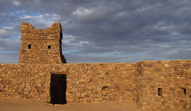
The archaeological site of Azougui: The first capital of the Almoravids, it is a fortress built in dry stone with a surrounding wall enlarged over time to a perimeter of several kilometres. It had a role in the trans-Saharan trade of ceramics and glass, imported from the Maghreb, the Iberian Peninsula, and the Near East. Imam El Mejdhoub, a major mythical and religious personality, and his follower Imam El Hadramy El Morady have tombs located in the heart of the site.
At the village, we met an unusual Scottish woman who had lived in Africa for 30 years and now had been in Azougui for 2+ years due to lack of funds. The village was relatively deserted but comes to life in the summer when many old residents returne to harvest the dates. They make enough money then to support themselves for the rest of the year.
Terjit Oasis. An oasis (in the proper sense: a desert spring or other water source), 45km by road south of Atar and popular with Mauritania’s few tourists. It nestles in a gorge of red cliffs on the western edge of the Adrar plateau with the palm grove stretching a few hundred metres alongside a stream that emerges from two springs that tumble out of the rocks. One is hot, the other cold, and they mix in a large, square, concrete basin. Two Austrians had arrived on public transport – I was disappointed when they were bathing in the basin.
We opted for a better swimming hole several kilometres away. Tourists can pay to stay in tents in the palm grove. In the summer, it is very busy but we saw only a few tourists. We drove offroad to a wonderful swimming hole formed by a depression in the riverbed and surrounded by lovely rocks. This is the last time we saw Dahid and my three friends. Ali had crossed the river so that we had a shorter carry for our lunch gear near the pool. On the way back, Ali paused for a shift over the center of the river and we were immediately mired in the quicksand. After three hours of digging, placing rocks for jacks and then placing rocks under the rear wheels and using branches, we amazingly extricated ourselves from the mess. I thought we would be camping here.
It was a 2-hour drive on a rough track to Chinguetti, mostly over a high flat rocky plateau.
THE ADRAR. The Unesco-listed Adrar is the undoubted jewel in Mauritania’s crown. It’s an epic Saharan country and shows the great desert in all its variety: the ancient Saharan towns of Chinguetti and Ouadâne, mighty sand dunes that look sculpted by an artist, vast rocky plateaus, and mellow oases fringed with date palms. For desert lovers, the Adrar is a must.
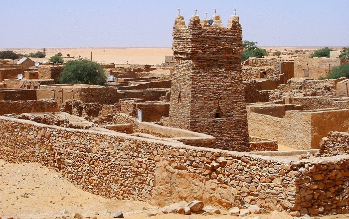
Chinguetti (pop 4000). One of the more attractive of ancient caravan towns in the Sahara, Chinguetti is Unesco World Heritage listed. It was once famous for its Islamic scholars, and was the ancient capital of the Moors; some of the buildings date from the 13th century. Chinguetti butts up against Erg Warane, Mauritania’s biggest stretch of dunes, and is more than enough to meet traveller’s expectations of the great Saharan sand ocean.
Ksar or qsar is the North African term for “fortified village”. Chinguettti was founded in the 13th century as the center of several trans-Saharan trade routes the city is seriously threatened by the encroaching desert. The western boundary is marked by tall sand dunes and several houses have been swallowed by the desert.
The town is divided in two parts by a wadi. On one side lies the old town, and on the other the new town. This is the third reincarnation of the old town – the previous two were abandoned as they were buried under the sand.
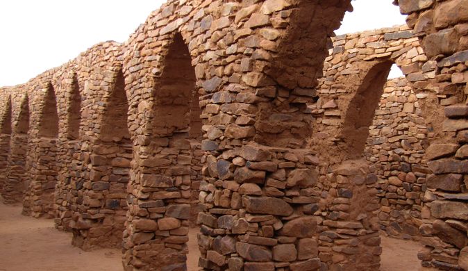
Before dinner, we walked into the old town, the highlight of any visit is a wander through the labyrinthine lanes of Le Ksar (Old Town). The main building that dominates the old town is The Friday Mosque of Chinguetti, an ancient structure of dry-stone construction, featuring a square minaret capped with five ostrich egg finials. The mosque was built in the thirteenth or fourteenth century, and it is believed to be the second oldest continuously used minaret in the Muslim world. We could not enter the mosque but looked through the door – many large white columns and a dirt floor.
Other notable buildings in the town include the former French Foreign Legion fortress; and a tall water tower. But among these, the most important is the famous libraries, giving the town the name “The City of Libraries”. The Old Quarter has five important manuscript libraries of scientific and Quranic texts, with many dating from the later Middle Ages.
We entered possibly the largest of the libraries and were shown several ancient books carefully stored in small boxes on the shelves.
The dunes are best seen by camels, but I have ridden camels before and wanted to avoid that experience.

Day 3 Tue Oct 18. In the morning, we drove 180 km to Oudane, passing through Tenouchert Oasis. We initially bypassed Oudane on our way to the Eye of the Sahara.
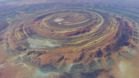
Eye of Sahara (Richat Structure) is a highly symmetrical, circular, and deeply eroded geologic dome in the Adrar about 60 km from Ouadane. Accessed only by desert tracks, it can only be entered through one gap in the rings. It is 40 kilometres (25 mi) in diameter, exposing sedimentary rock in layers that appear as concentric rings. Igneous rock is exposed inside as spectacular rhyolites and gabbros that form two concentric ring dikes and a central megabreccia. A kimberlitic plug in the northern part is dated to around 99 million years old.
It is not an impact structure. The circular distribution of ridges and valleys is explained as the formation of cuestas by the differential erosion of alternating hard and soft rock layers uplifted as a dome by an underlying alkaline igneous complex of the Cretaceous age.
The structure is also the location of exceptional accumulations of Acheulean archaeological artifacts along wadis in the outermost annular depression: stone tools, Neolithic spear points but no manmade structures.
We drove on sand tracks on a route that passed through gaps in the ridges to the centre elevated area where someone had built an auberge 20 years ago but hasn’t functioned for at least 15. There was an adobe toilet and several thatched structures where we had lunch in the shadow of the building. It was very hot and windy.

Chloum Railway tunnel. The town stands on the border between Mauritania and Western Sahara. In the early 1960s, the French in Mauritania wished to build the line from Nouadhibou to Zouérat to exploit the iron ore reserves at Zouérat. The Spanish authorities then responsible for Western Sahara negotiated to allow the railway to be built through Spanish territory over the relatively level desert but imposed conditions unacceptable to the French. The French engineers, therefore, built the line parallel with the border and tunnelled through the Choum hill spur — two kilometres through solid granite just to stay within French territory. The tunnel has been called a “monument to European stupidity in Africa”. The absurdity was highlighted when the southern part of the territory of Western Sahara was briefly administered by Mauritania after the Spanish withdrew in 1975/1976. The tunnel is no longer in use and a 5 km section of the railway now cuts right through the POLISARIO-controlled part of Western Sahara (21.354867°N 13.012644°W).
The N1 highway from Atar now runs on good pavement all the way north to Zouérat, but the sandy track paralleling the railway west to Nouadhibou traverses low dune cordons so is much easier in a 4WD.
Iron Ore Train. Before sunset, most travellers go to Choum station and wait for the iron ore train. There is no set schedule but every day the train stops at Choum station at approximately 9 pm. Those who want to ride the train overnight board the train. Goggles and a protective garment are usually provided. It is about a 12-hr ride, mostly through the night and thus cold with no views of the landscape except for the starry sky. The iron ore train has achieved “cult” status and is generally described as one of the most unpleasant experiences – constant dust from the iron ore while sitting for 12 hours on rock. Despite this, one only hears how tremendous an experience it is. I can only believe that the actual train ride, with the clickety-clack of the train on the rails, is a new experience for most. In my university days, one summer, I worked as a brakeman on the Canadian Pacific Railway – with Medicine Hat as the base, we worked the “fast track” on freight trains 300 km NW to Calgary and east to Swift Current. I loved the job but did not need to experience this train.
Arzu elected to get on the train in Zouerat for a more reasonable 5-6 hour trip. Boarding at 4 pm, the start is in daylight and avoids the long, cold night. Ali rode with her for company, and Ahmed and I returned to Choum, drove out into the desert and set up camp. I had a great 3-hour sleep. He returned to Choum at 9 and picked them up, both filthy from the constant blowing iron ore dust. Arzu “loved every second of it”.
I have learned to distrust other traveller’s accounts of their experiences as most forget how boring or unpleasant or the actual reality of them. They seem like “conspiracy theories” to me.
Day 6 Fri Oct 21. It was a long drive from the desert camp near Choum to Nouakchott (550 km) via Atar. Pass through eroded boulder fields and climb up two escarpments. Ali took the shortcut saving 40 km by again driving through the village of Azouge where he was born (it must have been depressing for him to see the ruin of the house he had purchased for his mother). It was 1 ½ hours total to Atar. We stopped to stock up on food and drinks at the Smash Market which carried many products desired by tourists.
The road passed through a flat Sahel bordered by sand dunes. We stopped at the same overhang we had used for lunch on our first day.
We arrived in Nouakchott in the afternoon.
Any train riders in the groups arrive in Nouadhibou at about 9 am and then have the long drive south to Noaukachott for their last day in Mauritania. It sounds exhausting.
I had had virtually no wifi for the entire 7 days and had a lot of business to conduct so had encouraged this long day of driving. A shower was welcome. I would also have all day to see the sites of Nouakchott the next day.
Day 7 Sat Oct 22.
NOUAKCHOTT
I spent the morning finishing business and updating Nomad Mania and this website at the hotel. Ali arrived at noon and we finished our financial transactions.
What a great hotel. It had great wifi. They had no checkout time and I hung around in my room, napped and had a shower at 4 pm. Ali arrived at 5 with Arzu and we had dinner at the hotel. We went for a short tour of some of the sights of Nouakchott and then went out to the airport for our late flight.
Port de Pêche. Urban Legends. The Port de Pêche is Nouakchott’s star attraction. Both lively and colourful, you’ll see hundreds of teams of mostly Wolof and Fula men dragging in heavy fishing nets. Small boys hurry back and forth with trays of fish, which they sort, gut, fillet, and layout on large trestles to dry (that must be the old way, we didn’t see any of this). The best time is in the late afternoon when the fishing boats return.
We went down at 5 pm. There were no nets but hundreds of boats already in and more coming. They ride the surf, usually broach and stabilize the front with an anchor. Then young men wearing green rubber jackets with doughnuts on their heads wade into the surf. Fish are shovelled out of the open boats into large plastic crates and carried into the market on their heads. It must be hot, back-breaking work. Getting the boats up the beach is torturous to watch. Each incoming wave moves the boat a foot or two. Eventually, they get the boats onto rollers (old metal cylinders). The boats are painted in wildly colourful designs and the long rows make for great photos.
Grande Mosquée, slender minarets, Looking into the doors, see endless white columns painted in stark black bas-relief patterns. Non-muslims are not allowed to enter. Probably the same French soldiers walked into the mosques with their dirty boots.
The nearby market was very rough with sandy dirt paths amid tables all selling the same stuff. After searching for an hour, I finally found some playing cards. One of the card games we are playing requires two decks.
Mosquée Marocaine towers over a bustling market area.
Musée National. Moderately worthwhile for anyone with an interest in Moorish culture. Prehistoric gallery with archaeological, ethnographic displays from Moorish society.
Nouakchott beach. There are two decent beaches around 5km north of the centre, Plage Pichot and Plage Sultan. Popular with the small expat community on weekends. Beware of undertows.
Saudi Mosque
Marche Capitale
Maurtainia Desert Voyages was a welcome breath of fresh air after 3 countries (Niger, Burkina Faso and Mali) where the guides were basically crooks intent on getting as much money from us as possible. Ali was the consummate professional.
Arzu was the best travel companion I have had so far in West Africa. She was not obsessed with photography which can get very tiring. She had no problem roughing it by staying in desert camps, sleeping on the ground and not having a shower every night. On her own without consulting me, she added Nouadhibou to see the ship graveyard which had been cleaned up and necessitated a big detour. Then the iron ore train was added, thankfully only for the 6-hour ride from Zouerat to Choum. That meant that we had to drive 200 km to Zouerat, wait in the heat for 4 hours for the train to arrive, return the same 200 km back to Choum and then wait in Choum until the slow train arrived. Thankfully, she assumed the $200 cost of this detour.
Departure: With Arzu and EC who were continuing to Algeria, Oct 22 @ 23:15-03:50+1 – NKC-ALG @ Air Algerie AH4015 (non-stop 3.5hrs)
Observations about Mauritania
1. Greetings. Whenever anyone is met, stranger or not, Mauritanians start the long ritualized banter asking about everything – their families, friends and how they are doing – it is the equivalent of “hi, how are you”. Both talk at the same time ignoring the other going on an on.
2. Landscape. I thought the country was one big flat desert, but in fact has a varied terrain of high escarpments eroded into short cliffs and jumbles of rock. After an unusually wet summer, seasonal lakes were common. There are few good highways and most of our travel was over minimal sand or dirt tracks that required a lot of local knowledge to route find. The best experiences are seen on these “detours”.
3. People. Mauritania is reputed to be one of the last remaining countries where slavery of the black population by the Arabs is still actively practiced. Ali’s opinion was that these black people were treated as part of one big, contented family and had little desire to leave the certainty of these relationships. Poorly educated or trained, they perf0rmed most of the manual labour. There is thus a huge economic disparity between these two populations.
Black kids are often barefoot, poorly dressed, filthy (like most third world countries, immaculately clean clothes are the norm), and doing much of the manual labour.
The majority of the population has migrated from their villages into the big cities. Villages are empty and the adobe buildings “melting” into the ground. Some past residents have built new houses that look conspicuously out of place. Many return in the summer to harvest dates or tend crops. They are escaping the heat and high humidity of the coast to drier and cooler higher elevations.
WHS
Parc National du Banc d’Arguin. This World Heritage-listed park occupies most of the Atlantic coast in northern Mauritania. It is an important stopover and breeding ground for multitudes of birds migrating between Europe and southern Africa, and as a result, is one of the best birdwatching sites on the entire continent. It extends 200km north of Cape Timiris (155km north of Nouakchott) and 235km south of Nouâdhibou. The ideal way to approach the birds is by a traditional fishing boat, best organised from the fishing village of Iwik.
Inside the park, there are official campsites that are equipped with traditional tents. Meals can also be ordered. There’s no public transport, so you’ll need to hire a 4WD with a knowledgeable driver, either in Nouakchott or in Nouâdhibou, allowing a couple of days for the trip. Permits are issued either at the entrance gates or in Nouâdhibou at the park office.
Tentative WHS
Site archéologique de Kumbi Saleh (14/06/2001). The site of Kumbi Saleh, the capital of the Empire of Ghana was discovered in 1914. The mosque is considered the oldest and largest mosque in West Africa, remarkably restored. Archaeological objects include epigraphic plaques, an astonishing coat of mail, and rare metal objects. The oldest date of the site dates back to the 4th century. The change in the axis of trans-Saharan trade to Tichitt, Oualata, and Timbuctou accelerated the abandonment of the city.
Site archéologique de Tegdaoust (14/06/2001). Tegdaoust was an essential stopover in the trade of gold, iron, and copper, the first stage on the road linking the Maghreb and Sudan. This city was very wealthy with a flourishing gold trade between the 8th – 13th centuries. Between 1050 and 1070, the Empire of Ghana was conquered by the Almoravids. Excavations show increasing aridity.
