
Brazil – Tocantins (Palmas) Jan 31- Feb 2 2022
I boarded my bus in Brazilia at 19:30 for the 14-hour ride to Palmas.
TOCANTINS (literally “Toucan’s beak”) is one of the 26 states of Brazil. It is the newest state, formed in 1988 and encompassing what had formerly been the northern two-fifths of the state of Goiás. Tocantins covers 277,620.91 square kilometres and had an estimated population of 1,496,880 in 2014. Construction of its capital, Palmas, began in 1989; most of the other cities in the state date to the Portuguese colonial period. With the exception of Araguaína there are few other cities with a significant population in the state. The government has invested in a new capital, a major hydropower dam, railroads, and related infrastructure to develop this primarily agricultural area.
Tocantins has attracted hundreds of thousands of new residents, primarily to Palmas. It is building on its hydropower resources. The Araguaia and Tocantins rivers drain the largest watershed that lies entirely inside Brazilian territory. The Rio Tocantins has been dammed for hydropower, creating a large reservoir that has become a center of recreation. Because it is in the central zone of the country, Tocantins has characteristics of the Amazon Basin, and also semi-open pastures, known as cerrado. The Bananal Island (Ilha do Bananal), in the southwest of the State, is the second-largest fluvial island in the world. Tocantins is also home to the Araguaia National Park, the Carajás Indian reservations, and Jalapão State Park, which is about 250 kilometres (160 mi) from Palmas. There, the rivers create oases in the dry landscape, attracting many eco-tourists to the region.
Tocantins is bordered to the northeast by the states of Maranhão and Piauí, Bahia to the east, Goiás to the south, Mato Grosso to the west, and Pará to the northwest.
Climate. Most of Tocantins (except the extreme western and northern regions) is situated within a vast Brazilian area known as the cerrado. The cerrado region’s typical climate is hot and semi-humid, with pronounced seasonal variation marked by a dry winter from May through October. The “cerrado” landscape covers 87% of Tocantins and is characterized by extensive savanna formations crossed by gallery forests and stream valleys. Cerrado includes various types of vegetation. Humid fields and “buriti” palm paths are found where the water table is near the surface. Alpine pastures occur at higher altitudes and mesophytic forests on more fertile soils. In the north of Tocantins the cerrado gives place to a zone of transition for the Amazon biome, near Tocantins River.
The “cerrado” trees have characteristic twisted trunks covered by a thick bark and leaves that are usually broad and rigid. The plant’s thick bark and roots serve as adaptations for the periodic fires which sweep the cerrado landscape.
Demographics: Pardos (brown, multiracial) (68.9%), 330,000 White people (24.0%), 95,000 Black people (6.9%), 2,000 Asian or Amerindian people (0.2%).
Economy. Major agricultural products are soy, maize, rice, pineapple, cattle. Palmas is located on the Belém-Brasília highway, vital for economic growth and the flow of production from Tocantins to other states and to ports on the coast.
I arrived in Palmas at about 09:30. The drive was through a lot of bush and agricultural land. The bus depot was a little depressing with several families with little kids living in the station in corridors between small shops.
My next bus to St Luis was for 21:30 (18 hours, 1,400 km), so I had 12 hours to spend here. I read, stored my pack at the bus company, and took a city bus 10 km downtown. After seeing the sites, I went to a mall, ate at a Burger King (easily the best food in Brazil), and spend several hours here using up time.
PALMAS (pop 307,000) is the capital and largest city located at the state’s geographic centre at an average altitude of 230 m. The city is located between the Serra do Lajeado hills on the east and the Tocantins River on the west.
Palmas was founded in 1990 and developed from the ground up in a former agricultural area intended to develop a relatively undeveloped area of the nation to provide better jobs for people. The city has a well-designed road system, and its urban zoning is modeled on that of Brasília. A symmetrical park lies at the city centre, and a large central avenue similar to Brasília’s extends north to south. The city is home to the Federal University of Tocantins.
In 2002, the Lajaedo Hydroelectric Power Plant was completed on the Tocantins River, creating a large reservoir and giving the city new beaches. The project also included the construction of a huge bridge: the Fernando Henrique Cardoso Bridge, 8 kilometers (5.0 mi) long, which connects Palmas with the major highway BR-153 and the district of Luzimangues in Porto Nacional.
The Palmas Airport (PMW) connects Palmas with many Brazilian cities.
The center of Palmas is a gigantic park with many things inside – from North to south:
a large cobbled square has 1. a statue of a family with 6 kids and a sheep 2. a sign celebrating the founding of Palmas in 1989, 3. flagpole 4. Centro Geodesico do Brasil (the geographic center of Brazil) and 5. the Palacio Gregviera.
On the south of the palace, it is more park-like with an artificial waterfall and rocks, trees, grass, and these two monuments.
Memorial Coluna Prestes. In the NM Military, War, and Police Museums series, this is the 2001 Oscar Niedermeier building about the Coluna Prestes (below). The work in concrete is marked by winding curves, characteristic of Niemeyer’s works.
The access ramp to the entrance and the bronze sculpture has a red color representing the blood that was shed for their country. The sickle shape symbolizes communism, which Prestes advocated. Completing the outside of the Memorial is the bronze sculpture “Knight of Light”, representing Luiz Carlos Prestes. The Memorial houses a collection of 81 original pieces on display that tell the story of the Coluna Prestes and its members, through photographs, documents, and personal objects. It also houses a pocket theater with a capacity of 87 seats, sound room, dressing room, and bathroom.
Coluna Prestes (Prestes Column), was a social rebel movement that broke out in Brazil between 1925 and 1927. The rebellion’s ideology was diffuse, but the main issues that caused it were the general dissatisfaction with the oligarchic First Brazilian Republic, the demand for the institution of the secret ballot, and the defense of better public education. The rebels marched some 25,000 km (15,534 mi) through the Brazilian countryside. They did not aim to defeat the forces of the Federal government in battle, but rather to ensure their survival and their ability to continue threatening the government. The young army officers occupied large parts of the city. However, they were soon besieged by increasingly numerous federal troops. After 3 weeks under heavy bombardment, the rebels abandoned their positions. Filling a train with men and supplies, they retreated into the countryside eventually reaching and occupying the city of Foz do Iguaçu in the state of Paraná, on the frontier with Argentina. There the rebels established a powerful defense line and waited for their enemies.
3 months after the retreat of the Tenentes from São Paulo, numerous army units also rebelled in the many other cities. An energetic response by the state government meant that soon the rebels were in disarray. Only in the region of São Luiz Gonzaga they were able to resist under the leadership of Captain Luís Carlos Prestes of the 1st Frontier Battalion of Santo Ângelo. Under his orders, the remaining rebel forces were reorganized.
In December 1924 fourteen thousand men loyal to the government marched towards São Luíz Gonzaga and started to fortify positions around the rebels. |Between February and March 1927, after crossing the Pantanal, part of the column led by Siqueira Campos arrived in Paraguay while the rest entered Bolivia. Upon seeing their precarious conditions, General Dias Lopes’ instructed the revolutionaries to go into exile.
Os 18 do Forte de Copacabana occurred on July 5, 1922, in Rio de Janeiro, It was the first revolt of the tenentista movement, in the context of the Brazilian First Republic. Although the 1922 revolt at Copacabana fort ended in failure, the sheer audacity by which the small band of rebels attacked a much larger force captured the attention of the public and inspired similar movements by the tenentes later on.[2] Some sources maintained that the uprising was doomed from the start because the authorities, including the Brazilian president, knew of the plot. The officers involved were also said to have accepted death.[3] These factors contributed to the way the rebels emerged as martyrs especially for their fellow soldiers.
Tenentismo is the political-military movement of various rebellions by young officers (mostly lieutenants) of the Brazilian army that occurred during the 1920s. The tenentes (lieutenants) called for reforms in the country’s power structure. Among these reforms was the end of the cabresto vote (a tool of political control through the abuse of authority, the buying of votes, the use of public institutions, violence, ghost voting, exchange of favors, and fraud). Other goals included the institution of the secret ballot, and the reform of public education.
In 1922 until 1930, the tenentes constituted a minority in the officer corps and the movement was based in only one part of society, the army, and this isolated the Tenentista movement from the rest of the society.
The Fort Copacabana rebels fired their cannons against many important government and military bases during the early morning of the 5th. Throughout the rest of the day, the fort was bombed. In the early morning of the 6th, 273 of 301 left the Fort. A destroyer and two battleships took up positions near the Fort and started to shell it. The government’s last word to the rebels was an order to either surrender or be destroyed. The Tenentistas still inside the Fort then cut a Brazilian flag in 29 pieces, one for each rebel, and decided to march to the Catete Palace, the head office of the Executive Power. Most of the 29 remained, but only 24 [4] were left (a civilian joined then to form this number). Walking down Avenida Atlantica next to the beach, they met a combined force of loyalist troops and police in the middle of Copacabana. Only Lieutenants Siqueira Campos and Eduardo Gomes along with four other rebels survived. A photograph first published in the daily, O Malho shows eighteen rebels. For that reason, the public still erroneously refers to those who took part in the battle on the insurgent’s side as “The Eighteen of the Fort”.
==============================================================
Brazil – Maranhão (Sao Luis) Feb 1-2, 2022
I arrived in Sao Luis at 23:00 after a 26-hour bus ride from Palmas and slept in the bus depot
MARANHAO (pop 7 million). Located in the country’s Northeast Region and borders on the Atlantic Ocean for 2,243 km and the states of Piauí, Tocantins and Pará. The people of Maranhão have a distinctive accent inside the common Northeastern Brazilian dialect. Maranhão is described in books such as The Land of the Palm Trees. The state has 3.4% of the Brazilian population and produces only 1.3% of the Brazilian GDP. it is the poorest state in the country of Brazil.
The dunes of Lençóis are an important area of environmental preservation. Also of interest is the state capital of São Luís, designated a Unesco World Heritage Site. Another important conservation area is the Parnaíba River Delta, between the states of Maranhão and Piauí, with its lagoons, desert dunes, and deserted beaches or islands, such as the Caju island, which shelters rare birds.
Geography. The northern portion of the state is a heavily forested plain traversed by numerous rivers, occupied by the eastern extension of the tropical moist forests of Amazonia. Much of the forest has been cleared for cattle grazing and agriculture, and the Babaçu palm produces edible oil which is extracted commercially.
The southern portion is the Brazilian Highlands, occupied by the Cerrado savannas.
The rivers of the state all flow northward to the Atlantic and a majority of them have navigable channels. The Gurupi River forms the northwestern boundary separating it from neighboring Pará, and the Tocantins River forms part the state’s southwestern boundary with Tocantins state.
The western coastline has many small indentations, which are usually masked by islands or shoals. The largest of these are the Baía de Turiassu, facing which is São João Island, and the contiguous bays of São Marcos and São José, between which is the large island of São Luís. This indented shoreline is home to the Maranhão mangroves, the tallest mangrove forests in the world. The coastline east of Baía de São José is less indented and characterized by sand dunes, including the stark dune fields of the Lençóis Maranhenses National Park, as well as resting forests that form on stabilized dunes.
Climate. The climate is hot, and the year is divided into a wet and dry season, extreme humidity being characteristic of the former. The heat, however, is greatly modified on the coast by the southeast trade winds.
History. The first European settlement was a French trading expedition under Jacques Riffault, of Dieppe in 1594. São Luís Island had a colony in 1612. The French were expelled by the Portuguese in 1615. Very successful Indian missions were begun by the Jesuits. In the late 18th century, there was a great influx of enslaved peoples into the region to cultivate cotton.
São Luís is the Brazilian state capital which most closely resembles a Portuguese city. The historic city center was declared a World Heritage Site in 1997.
Demographics. 4,271,000 Brown (Multiracial) (66.74%), 1,636,000 White (25.57%), 410,000 Black people (6.41%), 43,000 Asian people (0.67%), 39,000 Amerindian people (0.60%). According to a DNA study from 2005, it is 42% European, 39% native American and 19% African.
Economy. Maranhão exports: aluminium 50%, iron 23.7%, soybean 13.1% (2002).
Maranhão is also known as the land of palm trees and the most important is the babassu. The agricultural sector produces rice, cassava, soybean, cotton, sugarcane, corn, and eucalyptus. Natural gas in the Parnaíba basin is used in thermal power stations.
Arriving in Sal Luis at 23:00, all the bus companies were closed, so I decided to sleep in the bus station as I needed to know when buses left for Terasina the next day. I put on mosquito repellent and had a good sleep waking at 6 am, booked a bus to Terasina leaving at noon, ate breakfast (I always carry cereal and a banana), and took a city bus the 8.6 km into central Sao Luis. I was unable to store my pack at the bus station so had to bring the 45-pound heavy-weight pack with me. The bus turned 2 km from the center and I had a hot, humid walk to the church, arriving a few minutes before it opened at 8:30.
SAO LUIS (pop 1,108,975, metropolitan 1,605,305) is the capital located on Saint Louis’ Island), in the Baía de São Marcos (Saint Mark’s Bay), an extension of the Atlantic Ocean which forms the estuary of Pindaré, Mearim, Itapecuru and other rivers.
São Luís is the only Brazilian state capital founded by France. The historic center of the city (dating from the 17th century) has its original street plan preserved and was named a UNESCO World Heritage Site in 1997.
The city has two major seaports: Madeira Port and Itaqui Port, through which a substantial part of Brazil’s iron ore, originating from the (pre)-Amazon region, is exported. The city’s main industries are metallurgical with Alumar, and Vale.
Economy. Until the mid-nineteenth century, Maranhão’s economy was one of the most prosperous in the country. However, after the Civil War in the United States of America, when it lost space in the export of cotton, the state went into decline.
Historic Centre of São Luís World Heritage Site. The late 17th-century core of this historic town, founded by the French and occupied by the Dutch before coming under Portuguese rule, has preserved the original rectangular street plan in its entirety. Thanks to a period of economic stagnation in the early 20th century, an exceptional number of fine historic buildings have survived, making this an outstanding example of an Iberian colonial town. Located on the promontory formed by the Rivers Anil and Bacanga, northwest of São Luís Island, the Historic Centre of São Luís do Maranhão is characterized by its urban grid of streets lined with residential buildings of various heights, many with tiled roofs, painted ornamented cornices, tall narrow windows set in decorated surrounds and balconies with forged or cast-iron railings. They date from the 1615 plan laid out by Portugal’s chief engineer in Brazil, following the conquest of the fort that had been established on the site by the French in 1612. Harmoniously expanded through the 18th, 19th, and 20th centuries, the historic centre is an outstanding example of a Portuguese colonial town adapted to the climatic conditions of Equatorial America, with traditional Portuguese architecture adapted to incorporate raised piers and shuttered, wooden verandas. The singularity of the construction techniques employed is expressed in the elegance of the traditional Portuguese azulejos tile work applied both as insulation and decoration; in the modulated use of occupied and empty spaces reinforced by crafted stonework; and in the sharp contrast between the dense ornamentation of the facades overhanging the streets and porches that open wide from side to side into interior patios, lined by a continuous series of venetians, lattices, and frames.
The Historic Centre is however extremely vulnerable to abandonment and neglect, and measures are being taken to address this issue, despite the urban rehabilitation initiatives to restore the architecture and enhance the area’s landscape value.
The overlay of the various periods in the evolution of the Historic Center of São Luís, from the inception of the original site in the 16th century, reflected in the French fortifications; through the growth of the Portuguese city in the 17th century; to its splendorous moment in the 18th century as the capital of Grão Pará; and its rise as the homogenous aristocratic commercial metropolis of the 19th century, remain in evidence in the historic centre’s structural elements. The authenticity of materials and substance in buildings, street pattern and layout, and urban spaces is high and is respected by official bodies and inhabitants alike. Traditions, uses, and customs directly linked to Brazilian cultural identity continue to be maintained.
Igreja da Sé. This single-nave church has two small chapels in the cross and an elaborate gilt altar. The lovely vaulted ceiling is painted with fresh frescoes.
Museu Histórico e Artístico do Maranhão. Reviews the archaeology, history and ethnography of the state. Free
Reggae Museum (Music, Film, and Photography Museums). In a lovely 3-story house, it is the first reggae-themed museum outside of Jamaica and the second in the world. It was founded in 2018. São Luís is considered the capital of reggae in Brazil, having received the nickname of Brazilian Jamaica. The city has more than 200 radiolas, a name given to sound teams formed by DJs and stereos with dozens of powerful amplifiers stacked.
It explains how reggae was incorporated into the local culture since the 1970s when some people were able to receive short-wave Caribbean radio. In the ’80s and ’90s, reggae shows spread throughout São Luís. In 1984, the first reggae radio program, then local television programs, and then local bands, like the Tribo de Jah.
The reggae played in São Luís has a more romantic and sensual rhythm similar to local folk rhythms.
The main goal is to honor Bob Marley, the greatest reggae icon in the world. The Hall of Immortals honors the great names that have died of reggae in Maranhao. The other four venues exhibit the reggae clubs of São Luís: Pop Som Club, the Toque de Amor Club, the União do BF Club, and the Espaço Aberto Club. There are rare records, historical videos, and photos, reggae fashion over time, testimonials, digitized books, articles, theses and dissertations, in the Library of Reggae. It holds shows, musical festivals, meetings, workshops, and dance classes. 10 BR
Palácio dos Leões. Traditionally the Governor’s residence, it remains the residence and administration of the Governor of the state. The tour is guided and sees the second floor full of French furniture, glass, vases, art, chandeliers, and dishes. There are two English bronzes and two American vases. Free
Islands: São Luis island
M@P: Brazil – Maranhão extreme south (Gerais de Balsas microregion)
Tentative WHS: Lençóis Maranhenses National Park
Villages and Small Towns: Alcantara
World of Nature
Chapada das Mesas National Park
Gurupi Biological Reserve
Lençóis Maranhenses NP
Nascentes do Rio Parnaíba National Park
Waterfalls: Riachão: Santa Barbara Falls (Seven Falls)
Rivers
Parnaiba River
Tocantins River
Beaches
Atins Beach
Praia de São Marcos
Lighthouses
Barreirinhas: Farol Preguiças
Mandacaru: Preguiças Lighthouse
Cities of the Americas
ACAILANDIA
BACABAL
CAXIAS (Maranhao)
CODO
IMPERATRIZ
Airports: Imperatriz (IMP)
========================================================Brazil – Piauí (Teresina) Feb 2-3, 2022
PIAUI is one of the states of Brazil, located in the country’s Northeast Region. The state has 1.6% of the Brazilian population and produces 0.7% of the Brazilian GDP.
Piaui has the shortest coastline of any coastal Brazilian state at 66 km (41 mi), and the capital, Teresina, is the only state capital in the northeast to be located inland. The reason for this is, unlike the rest of the area, Piaui was first colonized inland and slowly expanded towards the ocean, rather than the other way around. In the southeast of the state, the National Park of Serra da Capivara is a UNESCO World Heritage Site. The park has more than 400 archaeological sites of prehistoric Paleo-Indian and sedentary-based Indigenous Brazilian complex cultures. and the largest concentration of rock paintings in the world, in a landscape dominated by canyons and caatinga.
History. In the 17th century, many impoverished noblemen and Jesuit priests, as well as black and Amerindian slaves, settled there. The first large-scale cattle farming also arrived with these settlers. Large estate owners seeking new pastures for their livestock.
At the beginning of the 20th century, the principal industry of the state was stock raising, A secondary industry was the raising of goats, which were able to stand neglect and a scanty food supply. Agricultural products were cotton, sugar, and tobacco. Forest products included rubber, carnauba wax, and dyewoods. Exports included hides, skins, rubber, wax, tobacco, and cotton.
Teresina was the first Brazilian city to be planned. In 1852, situated at the confluence of the Parnaíba and Poti Rivers, Teresina was (and still is) known as the Green City because of the countless mango trees that line the city’s streets.
Geography. Piauí is bounded on the west by Maranhão, on the east by Ceará, and Pernambuco on the south by Bahia. It has a short Atlantic coastline on the north.
Ecoregions. The sandy soils along the Atlantic coast are home to the Northeastern Brazil restingas, low evergreen forests adapted to nutrient-poor conditions. The lower basin of the Parnaíba is home to the Maranhão Babaçu forests, which extend westward into Maranhão. This ecoregion is dominated by stands of the Babaçu palm.
The eastern portion of the state is dominated by the dry Caatingas shrublands, which extend across much of northeastern Brazil. The Cerrado savannas extend across the southwestern portion of the state, in the basins of the upper Parnaíba and Gurguéia rivers. Enclaves of Atlantic dry forests lie in the basin of the Gurguéia, forming a transition between the Cerrado and Caatinga. Serra da Capivara National Park is located in the Caatinga of the south-central part of the state and protects numerous caves with ancient cave paintings.
Climate. The climate is hot and humid in the lowlands and along the lower Parnaíba, but in the uplands, it is dry with high day-time temperatures and cool nights.
Demographics. 3,164,000 people – 2,272,000 Brown (Multiracial) people (71.80%), 739,000 White people (23.36%), 145,000 Black people (4.60%), 41,000 Amerindian people (0.47%), 5,000 Asian people (0.17%), 2,000 Amerindian people (0.05%).
Religion. Catholicism (85.1%), Protestantism (9.7%). It is the state with the lowest proportion of Protestants, and the highest proportion of Catholics in the country.
Economy. Piaui is one of the poorest states of Brazil. The service sector 60.1%, the industrial sector at 27.3%. Agriculture represents 12.6% of GDP. Piauí exports include essential oils 19.5%, soybeans 17.1%, woven cotton 15.1%, cashews 12.6%, crustaceans 12.4%, and leather 8.3% (2002).
There is some mining in the state, including South America’s only opal mines at Pedro Segundo. Diamonds are mined by Gema do Piauí Mineração Ltda (Gemapi). The state has significant deposits of nickel and iron ore.
I caught the 12 noon bus from the Rodoviaria in Sao Luis for the 453 km, 8-hour drive to Teresina. We passed through almost exclusively heavily deforested pasture land and extensive palm forests. Like all of Brazil, everything is a verdant green as this is the rainy season.
I arrived at the Teresina Rodoviaria at about 8 pm, found out my bus ride to Forteleza the next day and walked across the street to my hotel for the night (Hotel Cidade Express).
TERESINA (pop 868,075) is the capital and most populous municipality in the Brazilian state of Piauí. Being located in north-central Piauí 366 km from the coast, it is the only capital in the Brazilian Northeast that is not located on the shores of the Atlantic Ocean. Together with Timon in the nearby state of Maranhão, it forms a conurbation with a population of about 953,172 inhabitants; the entire metropolitan region of Teresina has over 1,135,920 inhabitants. The only natural barrier that separates Teresina from Timon is the Parnaíba river, one of the largest in the Northeast.
It is among the 50 cities in the world with the highest murder rates, with 315 homicides in 2017.
Teresina is the hottest city in the country and the city with the third-highest incidence of lightning in the world. Nowadays, Teresina’s economy is based on international manufacturing industries and trade.
Located in a transition zone between the northeast and the Amazon (Mid-North), Teresina is surrounded by mata dos cocais, savannas and cerradões where many carnaúba, babaçu, buriti palms, jatobás, ipês, and many other medium-sized trees can be seen. In the region there are also remnants of Teresina Atlantic Forest, which makes the landscape shrub coverage very rich and dense.
I arrived at about 8 pm and walked across the street to my hotel, a fairly low-class affair. In the morning, I took an Uber downtown and back to see the following.
Piaui Museum. Shows the history of Teresina and of Piauí in general, including antiques, furniture, china, agricultural equipment, military uniforms, pots and on the ground floor an art gallery of local art. 5 BR
Karnak Palace. Karnak Palace is the official seat of the Piauí State Executive Branch. Formerly Karnak Palace was a farm of the Baron of Castelo Branco, and only in 1926 became the seat of the State Government and Governor’s Official Residence, in the management of Matias Olímpio de Melo. The last governor to reside in the palace was Petrônio Portella.
The name Karnak comes from an ancient Egyptian temple, and the palace architecture was inspired by Greek temples. During the Christmas periods, the palace is decorated and illuminated, including the gardens and the Piauí Symphony Orchestra. It is also where various honors, governor lunches, decisions, and political meetings take place.
Long pants required to visit. Free 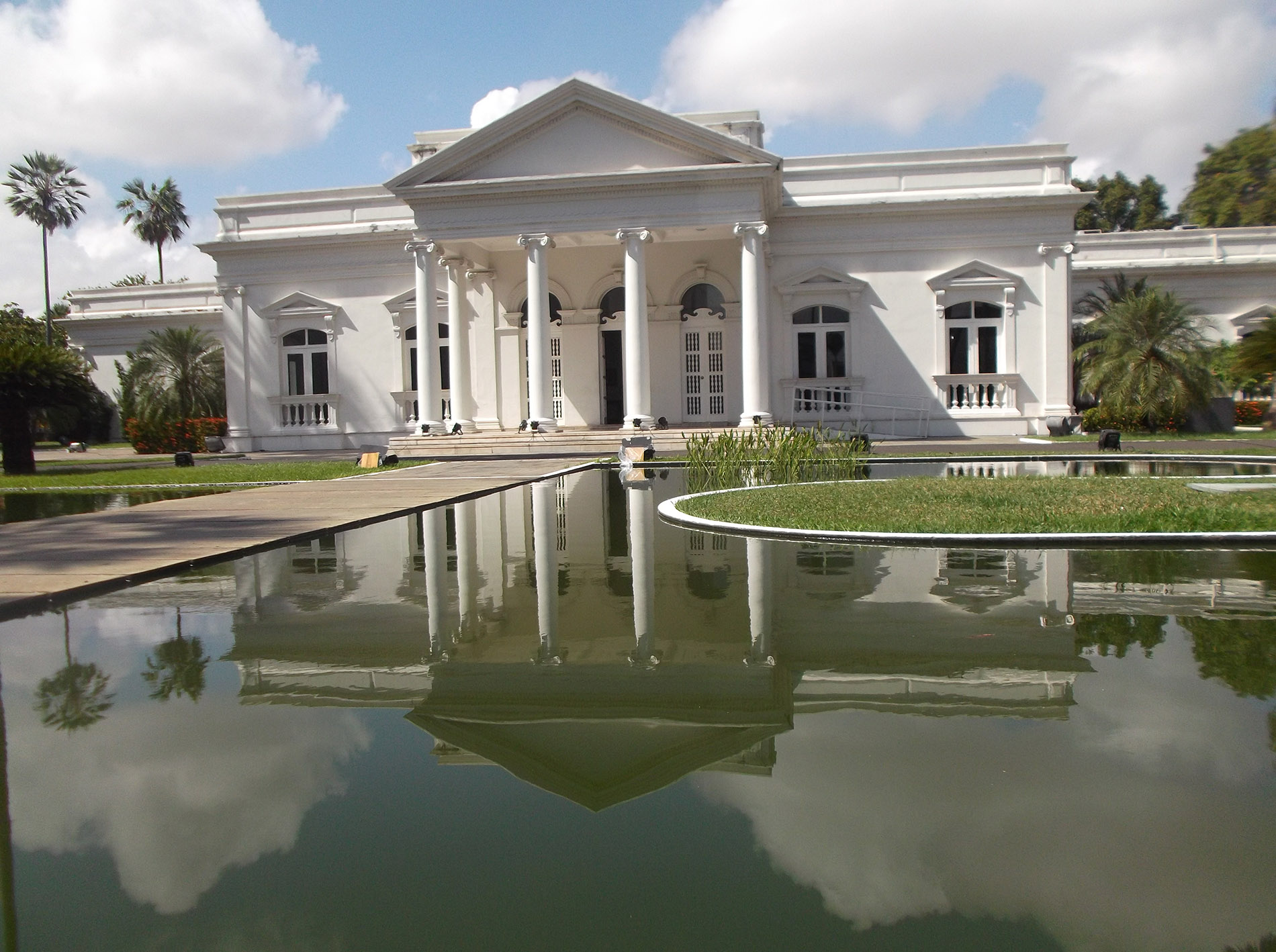 São Benedito Church. Igreja São Benedito is a Catholic church located in central Teresina. It is the third most important Catholic temple built in Teresina, next to the Metropolitan Cathedral of Nossa Senhora das Dores and the Church of Nossa Senhora do Amparo (Teresina) – Igreja Matriz.
Founded on top of a cemetery where blacks, lepers, suicides and indigents were buried, the unspoken story of the São Benedito Church reveals much of what Teresina society was like in the 19th century. It was naugurated in 1886 after 12 years of construction. To bury their dead, the main churches had the São José cemetery, but blacks weren’t welcome and the church was built, with the money, the sweat and enthusiasm of black slaves.
Built of masonry, with a ceramic industrial cane roof, vaulted ceiling, full-arch lintels and an external floor in ceramic tile, the Church of São Benedito is an imposing building, in Tuscan style like an Italian church, with pyramidal towers that rise more than forty meters high, a cruciform plan. In February 2-22, it was presently being renovated with the facade newly painted but the back still crumbling paint. 
I caught the 11 am bus (Real Maia 15 BR, 480 km, 10 1/2 hours) to Fortalezia.
M@P:
Litoral Piauiense (Coastal northernmost)
Piaui extreme southwest (Alto Médio Gurgueia and Chapadas do Extremo Sul Piauiense)
World Heritage Sites: Serra da Capivara National Park
Tentative WHS: Serra da Capivara National Park and Permanent Preservation Areas (16/09/1998)
World of Nature
Morro do Gritador
Parnaiba River Delta
Serra da Capivara NP
Serra das Confusões NP
Sete Cidades NP
Rivers: Parnaiba River
Beaches: Praia Barra Grande (Piauí)
Villages and Small Towns: Barra Grande
Cities of the Americas
PARNAIBA
