
BRAZIL – GOIAS (Goiania) Jan 26-28, 2022
This was my fifth major bus ride in as many days without getting accommodation, but I am very much enjoying it. Brazilian buses are quite unlike Canadian Greyhound buses as they have almost completely reclining and comfortable seats. It is necessary to have a blanket or sleeping bag as the air conditioning makes them uncomfortably cold. I also have a pillowcase I stuff with my down jacket. Most have USB plugs to keep electronics charged. Except at night with no view, it is lovely to sit, read, nap, read, nap……….. The view on almost every bus has been virtually identical – flat and either in the Amazon rainforest or on its fringes. In the south, deforestation is marked with agriculture as the main economy. The fields are either pasture with cattle or especially around Sinop fields of soybeans or peas.
After looking at the map, I realized that Goias was about 2 hours before Goiania so I asked the bus driver if he could drop me off. Goias is not a usual bus stop. I was left off on the highway, saw the neighbourhood of Goias Velho, and went down a street in that direction. It was very uninspiring so I stopped at what I thought was a municipal building and asked if I could talk to someone. My TIM data was not available for some reason (it turned out to be one company with no service in Goias). The building was the courthouse, but a lovely young guy who spoke good English came down and gave me a tourist tour of the town, telling me where the Historic Center was, the church, the bus depot, and suggestions for hotels and restaurants. I used his wife to mark everything in and walked a sweaty 20 minutes down to the Historic Centre, stopping off at Pousada Vovo Du Hotel (50 BR, fan only, a perfectly adequate place). It then proceeded to rain torrentially.
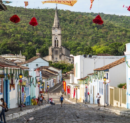
Historic Centre of the Town of Goiás WHS
Goiás testifies to the occupation and colonization of the lands of central Brazil in the 18th and 19th centuries. Although modest, both public and private architecture form a harmonious whole, thanks to the coherent use of local materials and vernacular techniques.
The Historic Centre of the Town of Goiás is built between two series of hills, along a small river, the Rio Vermelho. The area on the right bank is tight up against the north-western hills and has the church of Rosario, which was traditionally reserved for slaves. The areas on the left bank, limited by the hills to the south-east, are reserved for the more representative groups of buildings, including the parish church (today the cathedral) of Santana, the Governor’s Palace, the barracks, the Casa de Fundição (foundry), extending to the Praça do Chafariz and climbing towards the hill of Chapeu do Padre. Here are also to be found the historic residential quarter and a characteristic marketplace. The urban layout is an example of the organic development of a mining town, adapted to the conditions of the site.
The origins of the town of Goiás are closely related to the history of the official expeditions (bandeiras), which left São Paulo to explore the interior of the Brazilian territory. It was the first officially recognized urban core, the first borough to be planned West of the demarcation line of the Treaty of Tordesillas that defined the boundaries of the Portuguese possessions.
It is the last remaining example of the occupation of the interior of Brazil, as it was practiced in the 18th and 19th centuries. The Historic Center went through a long period of stagnation from the 19th century until recent times. Its townscape has therefore not been subject to any major changes in modern times. It has a rich social and cultural life. The relatively modest development of tourism reinforces the genuineness and authenticity of these cultural manifestations. For that reason, the Historic Center of the Town of Goiás is considered to have well preserved its historical authenticity.
The Historic Centre is lovely with streets of the roughest, large-stone cobble, all sunken and uneven. The mostly one-story homes and businesses are freshly painted in bold pastels. The church is a huge 3-nave church with frescoes depicting indigenous people and miners and nice pink/yellow stained glass in a geometric design. The church and Governor’s Palace surround a nice, leafy square. Cross the muddy river and Cora Coralina’s house is immediately to the left. I walked up to the other church.

Cora Coralina House, In the NM House and Biographical Museums series, this house was originally built in the 1770s. Born Ana Lins do Guimaraes Petsoto (1889-1985), she used the pseudonym Cora Coralina and moved into this house in 1956. She was a famous Brazilian poet who received many medals and awards. The house is just as she left it with its original appliances, furniture, photographs, and her clothing. The backyard is a verdant garden. 10 BR
Festivals: Goiás: Fogaréu. Early December to mid-January.
The bus schedule for Goiania at 10:30 with buses leaving at 10:40 and 3 pm. So I killed time and walked the 1.1 km up to the bus station.
The bus took a long 2 1/2 hours to reach Goiania. Don’t get off at the small stop on the west side of the city but wait for the Rodoviaria to disembark. It has a huge number of bus companies and adjoins a large mall. I ate a great burger at Burger King and walked the 1 km to my hostel, Zampollo (60 BR for a private room). We had another torrential downpour in the evening. This is the rainy season in Brazil.
GOIANIA (pop 1.536 million, metro area 2/65 million) is the capital and largest city of the Brazilian state of Goiás. It has a continuous geography with few hills and lowlands, with flatlands in most of its territory, especially the Meia Ponte River, Botafogo and Capim Puba streams.
Goiânia was a planned city, founded in 1933, to serve as the new state capital and administrative center. Brasília is 200 kilometres away. The city is an important economic hub of the region for industry, medicine, fashion, and agriculture. Goiânia has previously been described as having the largest green area per inhabitant in Brazil and the second-most in the world, after Edmonton, Alberta, Canada. With rapid population growth and urban expansion, satellite imagery shows the majority of the green area is now at the periphery of its sprawling city limits, and the per-capita green area claim may need to be reviewed.
The first state capital, Vila Boa (today City of Goiás), had been chosen when the economy was based on gold extraction. Later, when cattle-raising and agriculture came to dominate the state’s development, the old capital was considered remote.
Art deco. The first buildings were inspired by Art Deco. The collection of buildings is still representative, with 22 of them listed as National Heritage in the original center of Goiânia,
Climate. The city has a tropical wet and dry climate with an average temperature of 23.2 °C (73.8 °F). It has a wet season, from October to April, and a dry one, from May to September. Annual rainfall is around 1,300 mm (51 in).
The “cerrado” landscape is characterized by extensive savanna formations crossed by gallery forests and stream valleys. Cerrado includes various types of vegetation. Humid fields and “buriti” palm paths are found where the water table is near the surface. Alpine pastures occur at higher altitudes and mesophytic forests on more fertile soils.
Economy. The roots are agricultural for agricultural equipment, tools, fertilizer, and other products. Second are vehicle sales and vehicle service – repairs, sales and reconditioning. Third is government with many federal and state government agencies
The population of Goiânia is composed is white (47.95%), Multiracial (44.51%), Black (5.68%), Asian (1.68%) and Amerindian (0.16%).
Airports: Goiania (GYN)
As the check-out time at my hostel was 10 am, I left at 07:30 for a walkabout to see four museums. It was probably a fast 8+ km to see them all.
University Anthropology Museum. Pottery, tools, and ethnographic items emphasize the Amerindian culture of Goias. Free
Natural History Museum. Focuses on the ecosystem and how humans interact with it. A Historical town has been recreated, complete with schoolrooms and traditional homes. Two types of Indigenous villages.
Zoroastrian Museum Artiaga. With art-deco architecture, a style that marked the construction of his time, Professor (Teacher) Zoroastro Artiaga was founded in 1946 with a collection consisting of historical documents, old utensils, objects related to the Indians of Central Brazil, and artwork. Its name pays homage to the first director, Professor Zoroastro Artiaga, who remained in office until 1957 and then from 1964 to 1971.
Goiania Art Museum. In a lovely park with several ponds, this modern art museum has a little bit of everything – sculpture, prints, fibre art, but little that I liked. Free
I then walked the 1 km to the Rodoviaria to get a bus to Uberlandia in Minas Gerais West. This is a great bus station with every bus line in Brazil represented, a mall, and a great food court with a Burger King that has been my main meal for the last 2 days. The bus was Express (4.5 hours, 141 BR). I had a front seat with a great view.
==============================================================
MINAS GERAIS WEST (Uberlândia, Uberaba, Patos de Minas)
Is a state in Southeastern Brazil. It ranks as the second most populous, the third by gross domestic product (GDP), and the fourth largest by area in the country. The state’s capital and largest city, Belo Horizonte, is a major urban and finance center in Latin America, and the sixth-largest municipality in Brazil, metropolitan area is the third-largest in Brazil with just over 5,800,000 inhabitants.
With an area of 586,528 square kilometres (226,460 sq mi)—larger than Metropolitan France—it is the main producer of coffee and milk in the country, Minas Gerais is known for its heritage of architecture and colonial art in historical cities such as São João del Rei, Congonhas, Ouro Preto, Diamantina, Tiradentes, and Mariana. In the south, the tourist points are the hydro mineral spas, such as Caxambu, Lambari, São Lourenço, Poços de Caldas, São Thomé das Letras, Monte Verde and the national parks of Caparaó and Canastra. The landscape of the state is marked by mountains, valleys, and large areas of fertile land. In the Serra do Cipó, Sete Lagoas, Cordisburgo, and Lagoa Santa, the caves and waterfalls are the attractions.
History.
Indigenous inhabitation. The region where Minas Gerais is today was inhabited by more than 100 indigenous peoples as long ago as 11,400 to 12,000 years ago. They became targets of enslavement, and there are currently five groups:
The Brazilian gold rush (started 1693), gems, and later diamonds and enslaved African labor built the Estrada Real, the “royal road,” that connected Rio de Janeiro and Paraty to the mineral-rich regions of Ouro Preto, Serro, and, at the northernmost point, Diamantina. As the gold mines were exhausted over the 19th century, Ouro Preto remained the state capital until the construction of the all-new, planned city of Belo Horizonte at the turn of the 20th century. The people developed their own style of art, Barroco Mineiro, best shown in the richly decorated churches in the colonial cities.
During the 18th century, mining exploration was strongly controlled by the Portuguese Crown, which imposed heavy taxes on everything extracted (one fifth of all gold would go to the Crown). Several rebellions including the Inconfidência, started in 1789 by group of middle-class colonists, but it failed and the rebels were arrested. The most famous of them, Joaquim José da Silva Xavier (known as Tiradentes), was hanged becoming a local hero and a national martyr of Brazil.
Minas Gerais plays a pivotal role in shifting the economic axis from the Brazilian northeast (based on sugarcane, that starts declining in the 18th century) to the southeast of the country, which still remains the major economic center.
Demographics. In 2008, there were 19,765,000 people – White (46%), Brown (Multiracial) (45%), Black (9%), Asian (0.2%), 37,000 Amerindian people (0.2%). Córrego do Bom Jesus, in the extreme south, White people make up 98.7%. Setubinha, in the northeast, 71.8% are mixed-race and 14.7% Black. Southern Minas Gerais, had larger numbers of Portuguese farmers in colonial times. In the late 19th century, Italian immigrants also arrived. The north region, close to Bahia, was a place to the arrival of many African slaves since the 18th century. The central part of the state, where the capital Belo Horizonte is, has a more balanced ratio between White, Black and mixed people.
Religion. Catholic Church (70.4%), Protestantism (20.2%)
Economy. Minas Gerais is the second-largest consumer market, behind São Paulo – service sector 47.1%, industrial 44.1%. agriculture 8.8%. Main exports: mineral products 44.4%, metals 15.8%, vegetable products 13%, precious metals 5.5%, food 4.9%, transportation 3.5% metals. It is a major producer of milk, coffee and other agricultural commodities, Tourism is also important: historical cities like Ouro Preto, Mariana, Sabará, Congonhas, Diamantina, Tiradentes, and Sao João del Rey, are major attractions for visitors interested in their colonial architecture. Other cities, like Araxá, Poços de Caldas, Lambari, Caxambu, Lavras, and others, attract visitors interested in their mineral waterspring.
The state has the largest production of various precious and semi-precious stones in the country. In aquamarine, Minas Gerais produces the most valuable stones in the world. In diamond, Brazil was the largest diamond producer in the world from 1730 to 1870, mining occurred for the first time in the Serra da Canastra, region of Diamantina. It is the world’s leading producer of topaz. and tourmaline.
UBERLANDIA (pop 699,097 is located on the Brazilian Highlands 2,802 feet (854 m) above sea level. It is an important logistic hub between São Paulo and Brasília. It is one of the richest agricultural regions of Brazil. 580 km from São Paulo, and 560 km from Belo Horizonte
Municipal Market of Uberlândia
Municipal Museum of Uberlândia.
Sabiá Park is a park/zoo with vegetation of the Brazilian cerrado – trees with leathery leaves, twisted trunks, colourful flowers, and many fruits.
Rondon Pacheco Avenue: the “gastronomic corridor”, and the nightlife has many bars, restaurants, cachaçarias, pizzerias, cafes, ice cream parlours, and sweet shops.
Airports: Uberlandia (UDI)
I arrived in Uberlandia in the early evening, had a few hours and then caught a bus to Brazilia, arriving in the middle of the night.
==============================================================
BRAZIL – BRASILIA (Distrito Federal do Brasilia)
I took a bus with a nice bed seat and slept well. I arrived in the middle of the night and tried to sleep at the bus station. Laying on the floor is not allowed. I gathered my stuff and sat at an outside coffee shop for at least 3 hours reading. I then caught an Uber to my hostel arrived quite early, had a 3-hour nap, left my luggage, and started seeing the sites in the morning.
BRASILIA (pop 2,469,489) is the federal capital of Brazil. It is located at the top of the Brazilian highlands in the country’s Central-West region. It was founded by President Juscelino Kubitschek on 21 April 1960, to serve as the new national capital. Brasília is estimated to be Brazil’s third-most populous city. Among major Latin American cities, it has the highest GDP per capita.
Brasília was a planned city developed by Lúcio Costa, Oscar Niemeyer and Joaquim Cardozo in 1956 in a scheme to move the capital from Rio de Janeiro to a more central location. The city’s design divides it into numbered blocks as well as sectors for specified activities, such as the Hotel Sector, the Banking Sector, and the Embassy Sector. Brasília was inscribed as a UNESCO World Heritage Site in 1987 due to its modernist architecture and uniquely artistic urban planning.
All three branches of Brazil’s federal government are centred in the city: executive, legislative, and judiciary. Brasília also hosts 124 foreign embassies. The city’s international airport connects it to all other major Brazilian cities and some international destinations, and it is the third-busiest airport in Brazil.
History. Brazil’s first capital was Salvador; in 1763 Rio de Janeiro became Brazil’s capital until 1960. During this period, resources tended to be centred in Brazil’s southeastern region, and most of the country’s population was concentrated near its Atlantic coast. Brasilia’s geographically central location fostered a more regionally neutral federal capital.
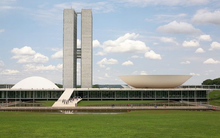
The Monumental Axis was assigned political and administrative activities and is considered the body of the city with the style and simplicity of its buildings, oversized scales, and broad vistas and heights. This axis includes the various ministries, national congress, presidential palace, supreme court building, and the television and radio tower.
The Residential Axis was intended to contain areas with intimate character and is considered the most important achievement of the plan; it was designed for housing and associated functions such as local commerce, schooling, recreation and churches, constituted of 96 superblocks limited to six stories buildings and 12 additional superblocks limited to three stories buildings; Costa’s intention with superblocks was to have small self-contained and self-sufficient neighborhoods and uniform buildings with apartments of two or three different categories, where he envisioned the integration of upper and middle classes sharing the same residential area. But at that time he did not foresee the growing population in the city. The capacity limit in his plan later caused the formation of many favelas, poorer, more densely populated satellite cities around Brasilia, peopled by migrants from other places in the country.
He also designed housing for the working classes that was separated from the upper- and middle-class housing and was visually different, to avoid slums (favelas) in the urban periphery.
One of the main objectives of the plan was to allow the free flow of automobile traffic, the plan included lanes of traffic in a north-south direction (seven for each direction) for the Monumental Axis and three arterials (the W3, the Eixo and the L2) for the residential Axis; the cul-de-sac access roads of the superblocks were planned to be the end of the main flow of traffic. The emphasis on automobiles caused the lengthening of distances between centers and it attended only the necessities of a small segment of the population who owned cars. But one can not ignore the bus transportation system in the city. The buses routes inside the city operate heavily on W3 and L2. Almost anywhere, including satellite cities, can be reached just by taking the bus and most of the Plano Piloto can be reached without transferring to other buses.
Later when overpopulation turned Brasilia into a dystopia, the transportation system also played an important role in mediating the relationship between the Pilot plan and the satellite cities. Because of overpopulation, the monument axis now has to have traffic lights on it, which violates the concept of modernity and advancement the architect first employed. Additionally, the metro system in Brasilia was mainly built for inhabitants of satellite cities. Though the overpopulation has made Brasilia no longer a pure utopia with incomparable modernity, the later development of traffic lights, buses routes to satellite cities, and the metro system all served as a remedy to the dystopia.
Paranoá Lake, a large artificial lake, was built to increase the amount of water available and to maintain the region’s humidity. It has a marina and hosts wakeboarders and windsurfers. Diving can also be practiced and one of the main attractions is Vila Amaury, an old village submerged in the lake.
Climate. Brasilia has a tropical savanna climate milder due to the elevation and with two distinct seasons: the rainy season, from October to April, and the dry season, from May to September. Average temperatures from September through March are a consistent 22 °. With 241.5 mm (9.5 in), December is the month with the highest rainfall of the year, while June is the lowest, with only 4.9 mm (0.2 in). During the dry season, the city can have very low relative humidity levels, often below 30%.
Demographics. (Multiracial) (48.2%), 1,084,418 White (42.2%), 198,072 Black (7.7%), 41,522 Asian (1.6%), and 6,128 Amerindian (0.2%).
In the city of Brasilia proper, the plano piloto was planned for about 500,000 inhabitants, a figure the plano piloto never surpassed, with a current population of only 214,529. From the beginning, the growth of Brasilia was greater than the original estimates. According to the original plans, Brasilia would be a city for government authorities and staff. However, during its construction, Brazilians from all over the country migrated to the satellite cities of Brasilia, seeking public and private employment.
Economy. Public Administration 54.8%, Services 28.7%, Industry 10.2%, Commerce 6.1%, Agrobusiness 0.2%.
Brasilia ranks 45th among the most expensive cities in the world in 2012, up from the 70th position in 2010, ranking behind São Paulo (12th) and Rio de Janeiro (13th).
The Federal District has the largest GDP per capita income of Brazil US$25,062, slightly higher than Belarus.
Architecture and urbanism. Even these positive features have sparked controversy, expressed in the nickname “ilha da fantasia” (“fantasy island”), indicating the sharp contrast between the city and surrounding regions, marked by poverty and disorganization in the cities of the states of Goiás and Minas Gerais, around Brasilia.
Critics of Brasilia’s grand scale have characterized it as a modernist Bauhaus platonic fantasy about the future: Nothing dates faster than people’s fantasies about the future. This is what you get when perfectly decent, intelligent, and talented men start thinking in terms of space rather than place; and single rather than multiple meanings. It’s what you get when you design for political aspirations rather than real human needs. You get miles of jerry-built platonic nowhere infested with Volkswagens. This, one may fervently hope, is the last experiment of its kind. The utopian buck stops here. — Robert Hughes, The Shock of the New.
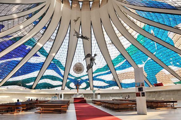
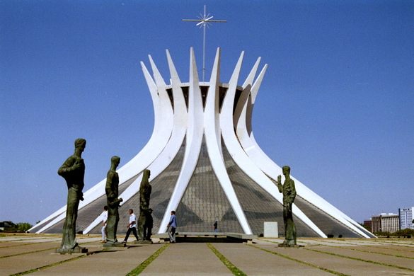
The Cathedral of Brasilia by Oscar Niemeyer is a concrete-framed hyperboloid structure, with its glass roof reaching up, open, to the heavens. Finished in 1970, the hyperboloid structure itself is a result of 16 identical assembled concrete columns.
Esplanada dos Ministérios (“Ministries Esplanade”), an open area in downtown Brasilia. The rectangular lawn is surrounded by two eight-lane avenues where many government buildings, monuments and memorials are located. On Sundays and holidays, the Eixo Monumental is closed to cars so that locals may use it as a place to walk, bike, and have picnics under the trees.
Praça dos Três Poderes (Portuguese for Square of the Three Powers) has the Palácio do Planalto (presidential office); the National Congress (Congresso Nacional); and the Supreme Federal Court
The Palácio da Alvorada is the official residence of the president of Brazil and designed by Oscar Niemeyer. It lies on a peninsula at the shore of Lake Paranoá.
The Palácio do Planalto is the official workplace of the president of Brazil and is the seat of government
Transportation. The Brasilia Metro has 24 stations on two lines, the Orange and Green lines, along 42 km (26 mi), covering some of the metropolitan area and is not comprehensive so buses may provide better access to the center. The metro leaves the Rodoviária (bus station) and goes south, avoiding most of the political and tourist areas. The main purpose of the metro is to serve cities, such as Samambaia, Taguatinga and Ceilândia, as well as Guará and Águas Claras.
Buses. The main bus hub in Brasilia is the Central Bus Station, located in the crossing of the Eixo Monumental and the Eixão, about 2 km (1.2 mi) from the Three Powers Plaza. The original plan was to have a bus station as near as possible to every corner of Brasilia. Today, the bus station is the hub of urban buses only, some running within Brasilia and others connecting Brasilia to the satellite cities.
In the original city plan, the interstate buses would also stop at the Central Station. Because of the growth of Brasilia (and corresponding growth in the bus fleet), today the interstate buses leave from the older interstate station (called Rodoferroviária) located at the western end of the Eixo Monumental. The Central Bus Station also contains a main metro station. A new bus station was opened in July 2010. It is on Saída Sul (South Exit) near Park Shopping Mall with its metro station, and is also an inter-state bus station, used only to leave the Federal District.
Rail. There is no passenger rail service in Brasilia, but the Expresso Pequi rail line is planned to link Brasilia and Goiânia.
Brazilia is a big spread-out city. The metro goes few places. The buses are hard to figure out, so I walked everywhere below up to the BBCC.
Dom Bosco Sanctuary. The Don Bosco is a work of light. An ultramodern reinforced concrete church, a perfect square with walls of high blue stained glass, and a huge central chandelier. Its walls are formed by 80 columns over 15 m high with high Gothic arches. The structures are 2,200 square feet of stained glass. The glass combines 12 shades of blue dotted with white. Inside, the feeling is of being under a starry sky. The architect Claudio Naves complemented the composition with columns rose-colored corners.
National Postal Museum. Lots of postal paraphernalia and of course, many stamps. Free
Caixa Cultural. Built in 1980, it has five galleries of quite interesting modern art, the Caixa Theater, and a Sculpture Garden. It tells the history of the bank and promotes theater, dance, music, literature, photography, and plastic arts with 5000 items such as typewriters and old safes, among other things related to Caixa Econômica Federal.
Cláudio Santoro National Theater is a multi-theatre building designed by Oscar Niemeyer in the Modern architectural style. Construction was completed in 1966. Built in the shape of a truncated pyramid, it is the largest building in Brasilia designed by Niemeyer specifically for the arts. It has three venues; the 60-seat Alberto Nepomuceno theater, the 407-seat Martins Pena theater, and the 1,407 seat Villa-Lobos theater. The complex also includes an exhibition gallery that is accessible to the public. The Theater was renovated beginning in 2014.

Cultural Complex of the Republic is a cultural center located along the Eixo Monumental formed by the National Library of Brasília and the National Museum of the Republic. Both buildings were designed by Pritzker Prize-winning Brazilian architect Oscar Niemeyer and inaugurated in 2006.
The National Library of Brasília is 14,000 square metres and consists of reading and study rooms, an auditorium, and a collection of over 500,000 items.
The National Museum of the Republic consists of a 14,500 square metres (156,000 sq ft) exhibit area, two 780-seat auditoriums, and a laboratory. The space is covered with a dome with ramps leading to the entrance. The building is mainly used to display temporary art exhibits. The mezzanine had a photography exhibit with interesting pictures of political protests that occurred in 1968. The huge bottom space had sculptures made from waste material, mostly metal, and was not very interesting. Free
Cathedral of Brasilia. Finished in 1970, the cathedral is a hyperboloid structure constructed from 16 concrete columns, weighing 90 tons each. In the square outside the cathedral, are four 3-meter (9.8 ft) tall bronze sculptures representing the four Evangelists. A 20-meter (66 ft) tall bell tower containing four large bells stands outside. A 12-meter wide reflecting pool surrounds the cathedral roof, helping to cool the cathedral. Visitors pass under this pool when entering the cathedral.
It holds up to 4,000 people and visitors enter it through a dark tunnel and emerge into a bright space with a glass roof. The outer roof of the cathedral is composed of sixteen pieces of fiberglass, each 10 meters (33 ft) wide at the base and 30 meters (98 ft) long inserted between the concrete pillars. Hanging over the nave are sculptures of three angels, suspended by steel cables.
The original stained glass used hand made glass and thus varied widely in thickness was replaced by uniform glass cut and assembled in Brazil from plates manufactured in Germany.
Itamaraty (Palace of the Arches) is the headquarters of the Ministry of Foreign Affairs of Brazil and was designed by architect Oscar Niemeyer and inaugurated on April 21, 1970.
National Congress building is the legislative body of Brazil’s federal government and is bicameral, composed of the Senate and the Chamber of Deputies. The Senate represents the 26 states with 3 senators each elected for eight-year terms. The Chamber of Deputies represents the people of each state, and its members are elected for a four-year term by a system of proportional representation proportionally according to each state’s population, with each state eligible for a minimum of 8 seats and a maximum of 70 seats.
Espaço Lúcio Costae. Under the centre of the large plaza, is this giant scale model of Brasilia, a braille model, and copies of his original plans. Free
Tancredo Neves Pantheon. In the NM Architectural Delights and Monuments series is a cenotaph dedicated to the honour of national heroes. It was conceived during the national shock following the death in 1985 of Tancredo Neves, the first elected civilian president after twenty years of military rule. Unlike other national pantheons, it is not a mausoleum and does not contain any tombs.
It is located in the Praça dos Três Poderes designed by Oscar Niemeyer as a modernist building symbolizing a dove. It has three floors: the exhibition area, has copies of documents, films by Silvio Tendler and interactive technologies.
The names of those honoured can be found in the Livro de Aço (‘Book of Steel’), between a sculpture in honour of the martyrs of the eighteenth-century uprising in Minas Gerais and the stained glass by Marianne Peretti.

Palácio do Planalto. Inaugurated in 1960, was the center of the celebrations for the inauguration of Brasília and marks Brazilian history by symbolizing the transfer of the Federal Capital to the center of the country, promoted in the Government of President Juscelino Kubitschek de Oliveira. It holds major events and also on special occasions such as the visit of foreign dignitaries.
Centro Cultural Banco do Brasil has two main galleries showing paintings and sculptures. Free
It was a long walk here. I could not figure out the buses.
Lake Paranoá is an artificial lake formed by damming the Paranoá River. Its circumference is 80 km. On its shores are embassies and consulates, sports clubs, restaurants, the residential areas of Lago Sul and Lago Norte, the University of Brasília, the Olympic Center, and the Palácio da Alvorada, the official residence of the President of Brazil.
Brasilia Botanical Gardens. This unusual garden is not meant to be walked but instead driven around the 4.7 km road. It is 80% natural cerrado forest with a Japanese garden and a visitor’s centre. Free
It was a 25 BR Uber ride, a real waste of money. I ended up taking the bus (5.6 BR, the 16 km back to the Rodoviaria about 2 km from my hostel and walked back.
The next morning, I saw the following sites, all relatively close to my hostel.
Memorial of Indigenous Peoples.
Opened in 1999 in another Oscar Niedermeyer building, this has an excellent display – feathered headdresses, photos, jewelry, baskets, pots, ceremonial cloaks, and rattles. The museum is round with a large gallery surrounding a central open area of many wood poles stuck in the ground (significance?). I was the only one in this museum. Free
This was a fairly long 5 km walk part through a large urban park with an amusement park, walking/jogging path, volleyball, a paddle game and lots of people watching on a Sunday morning. On the way back, I watched a drum troop for a while.
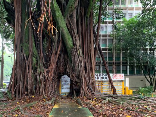
Wish Tree (Arvore dos Desejos, Banca da Arvore). At the first newsstand in Brasila, the owner planted a pair of rubber fig trees in 1963 alongside his newsstand, that with careful pruning grew together as a single trunk framing a perfectly formed doorway. Even better, the tree grants wishes. He kisses the tree three times a day thanking it for his business, 50-year marriage, 9 children, and 18 grandchildren.
Temple Of Legiao Da Boa Vontade. Opened in1989, In the shape of a pyramid, the Temple of Good Will draws a lot of attention from pilgrims and tourists from all over the world. There are seven sides, covered in white marble, in the heart of the capital of Brazil. However, the interior of the monument is what most fascinates: the place provides self-reflection and peace.
The Legion of Good Will (LGW) was founded by Alziro Zarur (1914-79), is in 7 countries, and has 80 churches in Brazil. It does social things like running schools for the poor. The church was built by Pavia Netto. At the top of the pyramid is a large crystal. The pews are around the sides of the temple with the centre clear and a meditative walk that arrives at the centre. There is a whole complex to the side and under the temple – awards from countries (including a menorah and a koran), an Egyptian room, a wall of 100 portraits of famous people, an art gallery, a gift store highlighted by several large crystals, an office and the tomb of Mr Zarur.
On January 30, I caught the bus from Brazilia to Palmas, Tocantins State at 19:30 and arrived 14 hours later.
