
Cyprus – Southern (Nicosia, Limassol, Paphos, Larnaca, Agia Napa) October 12-24, 2021
Day 1
I flew from Santorini via Athens on Aegean Airlines (online check-in mandatory + need to have filled out the Cyprus Flight Pass to board the plane, need vaccination but no Covid test).
I had not been able to find a good rental car online (all over 400 for 7 days) so I arrived at the Larnaca Airport needing one. I stopped first at a local agency, Astra Cars and they had a small Kia for 220 + 49 for premium insurance. It has turned out to be a lovely little car to drive. I had initially rented if for Oct 12-19, but on the 13th extended the rental till my departure day on Oct 24.
Hostelworld had no hostels and I mistakenly booked an expensive hotel on the site. Then I tried Booking.com and they listed the Past or Tail Hostel in Larnaca. It turned out fine and met a very nice Russian and an English guy. I miss hostels for those connections. I canceled the hotel.
Church of Panagia Aggeloktisti Tentative WHS (09/02/2015). I saw this Greek Orthodox church on my way into Larnaca from the airport. It is an old stone building. The pulpit, pressius, bishop’s throne, and iconostasis are all intricately carved.
Day 2
Larnaca Salt Lake. Drive beside this large dry lake bed from the airport into town. The Tekke is on the western edge.
Hala Sultan Tekke and the Larnaka Salt Lake Complex (08/02/2016). The tekke consists of the mosque, the tomb, guest house, and kitchens. Hala Sultan arrived in Cyprus in 648 AD, the first Islamic woman to take a sea voyage. Shortly after her arrival, she fell from a horse and died. Her husband, the first governor of Palestine, built the original complex. Her tomb sits in an adjoining building attached to the back of the mosque. It can’t be entered and is disguised behind heavy green curtains,
so one sees no details but the white marble side. A small graveyard sits beside the mosque. Mosque of Unim Haram. Built in 1700, the stone building has a narthex and a square prayer area under a large plain white dome. The mihrab is stone and the minbar and windows green. Free. Shorts not allowed.
LARNACA
Larnaca Fort (Medieval Fort). This was founded by the Byzantines in the 12th century. On the shore in the middle of town. It has several canons and a museum. Not very interesting. 2.50
Pierides Museum. The Pierides family moved from Venice to Cyprus in 1750. Demtrios was beheaded by the Ottomans in 1851 as he would not renounce Christianity. Virtually every generation has been a collector of ancient Cypriot artifacts so that today, the collection amounts to 2500 pieces, 650 of which are folk art. This is an outstanding collection dating to Neolithic times (the “screaming man”) through the ages. It must be the largest collection of Roman glass I have ever seen. The 14th century painted bowls are also very good. 2.50
Oroklini Lake. About 7 km north of Larnaca, this small lake appears over half dry with a large “beach” of the exposed lake bed. It is a designated protected area, part of the EU Natura 2000 network. Two threatened species nest here, the spur-winged lapwing and the black-winged stilt.
The lake is hidden from view everywhere by reeds and dense thickets of Russian and can only be seen from a tiny area with parking on the NW corner. There were flamingos in the water
Pyla is a village in Larnaca District. It is one of only four villages located within the United Nations Buffer Zone, the other three being Athienou, Troulloi and Deneia. Pyla is located in the eastern part of the island, adjacent to the British Sovereign Base Area of Dhekelia. From a legal point of view, it is administered as all other areas controlled by the government of the Republic of Cyprus, but policed by UN peacekeepers.
The village is special in the respect that it is the only settlement in Cyprus still inhabited by both its original Greek Cypriot and Turkish Cypriot inhabitants.[3] 850 of the inhabitants are Greek Cypriots and 487 are Turkish Cypriots.[4] The village has three churches and one mosque.
Pyla is among the oldest villages in Cyprus. The village was first inhabited during the Middle Ages. On several old maps, it is marked with the names Pila or Pilla.
Pyla Tourist Area is the area that neighbours the sea and belongs to the administrative division of the village of Pyla.
Several of the most luxurious hotels in Cyprus are located in the tourist area of Pyla, such as: Golden Bay, Lordos Beach and Sandy Beach. This strip is lined with a mix of taverns and restaurants, as well as tourist shops and boutiques, which all run parallel to the beachside which offers organized facilities, as well as kiosks and ice-cream stands. Pyla Tourist Area continues through the new Larnaca-Dhekelia sea road, onwards to the C.T.O. (Cyprus Tourist Organisation) beach.
CYPRUS REPUBLIC EXCLAVES within BBA Dhekelia Cyprus Republic (also the Power Station)
Xylotymvou. A very ordinary town with nothing to see that I could find.
Ormydeia. Ditto
Cyherbia Botanical Park and Labyrinth, Avgorou. Cypress trees are planted in the shape of Cyprus to form the “Walk Around Cypress” to see indigenous trees of the island planted in rather orderly roads. Also a herb garden, a few flowers, and a tea room/garden. The grounds and the maze are formed by a dense growing evergreen bush that is well manicured to form the boundaries. 5€including a cup of herbal tea.
AYIA NAPA
Ayia Napa Beaches (Makronissos Beach). A small beach that is very busy with lounge chairs and umbrellas 11-deep. Has a nice snack bar and picnic tables to sit at and have lunch.
Sculpture Park. This huge park has more than 100 large sculptures, most from a yellow stone, some marble and some metal. Most are Eastern European artists – Russia, Ukraine, Bulgaria but a few from around the world – China, Taiwan, Chile, Peru, Italy and of course Cyprus. They were all made from 2015-2018 and seem to be part of a yearly festival. A neat bridge made of metal resembling a boat has many metal knights. Free.
CAPE GRECO
Cape Greco Lighthouse. Unfortunately, this has a large razor wire fence so it is not possible to even see the lighthouse. There are 4 large and two small communication towers.
Cape Greco National Forest Park. There is not much forest here, just low desert bushes on limestone
rock.
Cape Greco Nature Reserve. Encompasses the lighthouse area. Limestone rock terraces above low
cliffs
Cyclops Cave. Park before a gated community, walk down the road, and turn right onto the Konnos Nature Trail. It eventually turns left to follow along the edge of the low cliffs. Finally, reach the cave on top of the cliffs. It is rather underwhelming – small and varying from 3-6 feet high with two natural rock
supports for the roof. The only value in coming here is for the walk and the pretty coast.
Church Of Profitis Elias, Protaras. Greek Orthodox church on top of a hill looking over the town and sea. It was built in 1984, in the place of an older chapel. They used stones locally found so as to fit in with its surroundings and complement nature around it.
Climb stairs to the small stone chapel with a tree behind it. This tree has ribbons and strips of cloth tied to its branches in remembrance of a loved one.
The inside of the church is adorned with frescos from wall to ceiling and the outside of the chapel is all lit up at night.

Ocean Aquarium, Protaras. Fish, 2 penguins, a raccoon, monkeys, alligators, and birds. These places are for kids. 14, 10% reduction if over 65
On October 12, I left South Cyprus and crossed into North Cyprus, the Turkish north of the country.
Crossing the Cyprus-Northern Cyprus border was the usual Turkish nightmare. First stop and they scan your passport and check your vaccination status. Then stop at a second kiosk. If you have been on the Greek side for less than 10 days, you must return to a pharmacy on the Greek side and get a rapid Covid test. I turned around – the first 3 pharmacies close on Wednesday afternoon, so I kept going. The fourth pharmacy was open and I had a negative test (6 ), returned, and then had to purchase Turkish car insurance – 3 days for 20 (actually 2 days and 18 hours as it starts at noon and I was there at 6 pm).
Day 4
On October 15, I returned to South Cyprus.
Archaeological Museum of Marion-Arsinoe, Polis. Has the usual collection of antiquities from the Neolithic to Medieval times and also from the ancient necropolis.
Marion was an important commercial centre in the Classical and Hellenistic periods, with close ties with Athens. During the Hellenistic-Roman period, Marion was renamed Arsinoe and is now the small town of Polis Chrysochous, commonly known as simply ‘Polis’.
Day 5
Akamas Peninsula area (extreme northwest) M@P
Akamas Peninsula NP. This is a rugged place with roads suitable only for high-clearance vehicles, preferably 4WDs.
Anyone who tries in their family sedan soon turns around on the nightmarish roads.
I then went to nearby Peristeronas to see the Tentative WHS 5-domed churches and after an hour, found out there is another Peristeronas, about 23 km west of Nicosia.
Adonis Baths Waterfall. Google Maps persisted in taking me on a dead-end road but I eventually overroad her and found the waterfall. Persistent signs said the awful road was “good for any vehicle” and it turned out to be a tourist trap.
There are 4 bad statues but a nice little museum about the original mill owner and the wood bed on which he sired 20 children. The water wheel is also interesting – the water was channelled to a tower and was directed to the novel wheel.
The waterfall and pool are lovely but there are no upper falls and no gorge. I went for a swim in the cold water and washed my hair and had a bath, despite it probably is not permitted. There were many people here but few in the cold water. 9€

Agios Neophytos Monastery. There are 3 parts: 1. the 4 small cells dug into the cliff have nice frescoes mostly intact. 2. The old church is a typical Greek Orthodox but with nice frescoes in the dome behind the altar. The museum has some nice silver-covered gospels, typical religious artifacts, pottery, and several ancient maps. 2
Lempa. The Chalcolithic site dates from 3000 BC. They worshipped a god who protected children and infants. Besides the low ruined walls are reconstructed round structures – 4 small and one large with abstract red designs outside and in.
Kato Paphos Archaeological Park. Founded in 320 BC by Nicolos, the last king of Paleophaphos, it was the capital of Cyprus under the Ptolemies and Romans
PAPHOS
Tomb of the Kings. Used primarily during the Ptolemaic and Hellenistic periods, these burial structures were not used by kings, but by rich and higher officials of the Ptolemaic state. There are 7 magnificent burial chambers cut into the limestone. All have several loculi for single burials and most have aisles supported by columns hewn from the rock. 2.50
Paphos Lighthouse. This lovely white round lighthouse sits adjacent to the WHS. Access is difficult to find.
Paphos Castle. Sitting in the sea, this small square castle has no courtyard but nice arched rooms. There was a display of art made from marine debris and an extensive series of photographs and explanations about the Akamas Peninsula. The only other thing to do is climb onto the roof for good views. 1.25 reduced
Nea Paphos Archaeological Site. A World Heritage Site, this large site’s only nice things are the wonderful mosaics. Several are housed under a large roof and some remain in the ruins. Typically there is little interest outside of these. 2.50 reduced
Byzantine Museum
Temple of Aphrodite (Sanctuary of Aphrodite at Palaepafos), Kouklia. Dating to 1300 BC, typically the ruins are not inspiring except for some gigantic rocks used in the construction. Don’t miss the museum, housed in a sugar factory headquarters. The best is a 5th-century BC sarcophagus with carved scenes and relatively vivid colours. There are also three very nice bathtubs.
Petra Tou Romisu. This large rock half in the water is the birthplace of Aphrodite in Greek mythology. On both sides is a rock beach that was busy even late in the day. Swimming around the rock guarantees everlasting love.
Biceria St Ileuon. This small Greek Orthodox church sits high above the valley. It is relatively modern-looking, all white, and has a nice bell outside. Despite the hours being listed as open till 6 pm, it wasn’t. The drive here was up a switchbacking road with some of the tightest hairpin turns that required backing up. Photos of the inside show a modern church with a carved wood iconoclast.
On the drive to Fyti, the road followed a high ridgeline with long views to the south. I passed a very high-end housing development called Mithris with a golf course and lovely architecture in the homes.
Fyti. A NM small town, this is where I ended my day. I ate at the Fiyt Taverna, a hangout place for the locals. Two old men drank beer, one guy did nothing and another down-and-outer drank beer, all the while watching an insipid Greek soap opera on the TV. I had souvlakia and chips. My computer recharged. The local parish church had a service attended by 4 old women.
Day 6
Chrysoroyatissa Monastery, Pano Panagia. Tentative WHS (extension to “Painted Churches in the Troodos Region”) (04/02/2002). A three-aisled church of the steep-pitched roof type with flat hooked tiles. The aisles of the church are divided from the nave by wooden arcades. The church retains a considerable number of paintings from the early 16th century. They are of an Italo-Byzantine style and iconography. Its wood-carved gilded iconostasis is a fine example of early 16th-century work with a contemporary series of icons in the same style.
I entered during the 7 am mass – 3 in the congregation, 3 priests with their long grey beards and long black frocks and hats, the monotone chant, a guy walking
around swinging a set of bells, lots of bowing and crossing. The iconostasis here is a wonder of gilt and carving.
Pano Panagia. A NM small town, it is the birthplace of Archbishop Makarios.
The drive to Kykkos was 35 km and took an hour along a very good road without a straight piece longer
than 100m, but maintaining an almost constant elevation. It passed through the Paphos Farhan Forest, with wonderful mature pine trees. It was a rainy, cold, and windy day. I didn’t meet another vehicle, making cutting corners safe, but there was a lot of rock on the road.
Kykkos Monastery, Pedoulas. Wow, don’t miss this monastery, probably the most spectacular in Cyprus. The courtyard had many lovely mosaics. The inside with 2 aisles is completely covered in frescoes, all freshly painted, a mammoth gold iconostasis, hundreds of hanging candaleria (candles burning oil) and at least 30 tall brass candle stands. I entered mass with at least 40 in the congregation and not all ancient. Chandeliers hang everywhere.
TROODOS Troodos is spectacular all year round. During the summer months, it is a fantastic escape from the hot and humid temperatures. During autumn and spring when greenery is at its peak and blossoming, the forest park is great for activities and short breaks. In the winter season, the slopes are dressed in white and offer majestic and scenic views; perfect for relaxation, excursions, and skiing under the usually clear and sunny sky.
Troodos Mountains is an enthralling area offering beautiful agrotourism resorts, picturesque villages, UNESCO World Heritage Byzantine churches and monasteries, wine-making villages, pine forests, amazing fauna and flora, natural beauty and traditional cuisine. Furthermore, it is ideal for activity fans including hiking, climbing, skiing, rambling, mountain biking, nature study, photography, and pictures.
Painted Churches in the Troodos Region WHS. The complex comprises ten Byzantine churches and monasteries richly decorated with Byzantine and post-Byzantine murals:
1. Church of Agios Nikolaos (St. Nicholas) tis Stegis in Kakopetria: An 11th-century monastery and the oldest surviving katholikon in Cyprus
2. Agios Ioannis (St. John) Lampadistis Monastery in Kalopanagiotis: A 13th-century monastery
3. Church of Panagia (The Virgin) Phorviotissa (Asinou) in Nikitari: A 12th-century church
4. Church of Panagia (The Virgin) tou Arakou in Lagoudhera: A 12th-century church
5. Church of Panagia (The Virgin) in Moutoullas: A 13th-century chapel and the earliest example of steep-pitched wooden roofs
6. Church of Archangelos Michael (Archangel Michael) in Pedoulas: A late 15th-century church
7. Church of Timios Stavros (Holy Cross) in Pelendri: A church containing unique 14th-century wall paintings
8. Church of Panagia (The Virgin) Podithou in Galata: An early-16th-century church
9. Church of Stavros (Holy Cross) Agiasmati in Platanistasa: A 14th-century church
10. Church of Agia Sotira (of the Transfiguration of the Savior) tou Soteros in Palaichori Oreinis: A 16th-century church.
Initially, nine of these churches were designated by UNESCO in 1985 with the church in Palaichori added to the list in 2001. The Church of *Panagia Chrysokourdaliotissa in Kourdali, Spilia, was submitted as a potential further extension in 2002 and currently resides on the Tentative List.
In 965 AD, Cyprus was annexed by the Byzantine Empire in the Arab-Byzantine wars. Over 500 years until the 16th century, many Byzantine churches were constructed in the Troödos Region. This region holds one of the greatest concentrations of monasteries and churches in the former Byzantine Empire. The World Heritage Site includes a variety of churches, ranging from small chapels to grand monasteries. These sites demonstrate the range of architectural and artistic influences affecting Cyprus over the entire Byzantine reign. However, all sites display some architectural elements that are unique to Cyprus, including steep-pitched wooden roofs with tiling.
Agios Ioannis (St. John) Lampadistis Monastery in Kalopanagiotis: Painted Churches in the Troodos Region WHS. A 13th-century monastery. Once totally frescoed inside, some have disappeared and are now painted white. A painting of Mary
has many offerings of wrist bracelets and wax dolls (and a red heart), asking for favours like pregnancy.
The church has an odd shape as if added onto many times. People kiss the icons.
Church of Panagia (The Virgin) in Moutoullas. Painted Churches in the Troodos Region WHS. A 13th-century chapel and the earliest example of a steep-pitched wooden roof. It is not easy to find. Walk up the road, then turn left on some stairs. It was supposed to be open until 3 pm but wasn’t.
Church of Archangel Michael in Pedoulas. Painted Churches in the Troodos Region WHS. A late 15th-century church built in 1474 where the frescoes are actually signed by the artist and use a lot of red scenes from both the Old and New Testament. It was not open.
Church of Timios Stavros (Holy Cross) in Pelendri: This imposing modern church was built in 1935 but a post-Byzantine iconostasis and many frescoes.
Kakopetria. A NM small town.
Agios Nikolaos tis Stegis. The only 2-story painted church, it is a wonder inside with frescoes covering every surface.
Trooditisa Monastery, Troödos. Is situated on the southern slopes of the Troodos Mountains. It is an Orthodox monastery dedicated to the Virgin Mary founded in 990, but the current church and buildings date back to 1731. It is built at an altitude of 1,500m (4566 feet) and the closest village is Platres.
The Holy Monastery of Trooditissa is estimated to have been founded after the period of iconoclasm. The earlier buildings, which were of the middle Byzantine period (12th century) are not saved.
The most important relic of the monastery is the thaumaturgist icon of the Virgin Mary, originally from Asia Minor and is known for its wonders to childless married couples who wish to have a child. The church celebrates on 15 August, during the feast of the Assumption.
It is lovely inside with a wood ceiling, frescoed walls, a nice carved vespin and iconoclast, and many candelaria and brass candle holders.
Pano Platres. A NM small town.
Hotel Helvetia, Platres. In the NM Hospitality Legends series, it in a 1929 stone building, and is one of the oldest hotels in Cyprus. It is run by the 4th generation of owners. A 250-year-old pine tree growing through the roof is the centrepiece of the lobby, which also features an ancient brick fireplace.
Caledonia Waterfalls. Park on the road outside the fish farm and walk approximately 2.5km on initially a cement path and then a rocky path that follows the creek. The waterfall was out of season but is about 15 m high falling into a small pool. It took me 25 minutes to walk down.
Mt Olympus. At 1,952 metres (6,404 ft), it is the highest point in Cyprus. A British long-range radar currently operates at Mount Olympus’ peak. You can drive almost to the top until the fence and razor wire stop you – it is a forbidden military zone.
Writing in the late first century BC or first century AD, the geographer Strabo reported that on one of its promontories was a temple to Aphrodite Acraea (Aphrodite of the Heights), which women were forbidden to enter.
The Mount Olympus Ski resort consists of the Sun Valley and North Face areas. Each area has its own ski lifts and runs, operated by the Cyprus Ski Club:
Giant Black Pine. Near the top is a 300 m trail to this 500-year-old tree. There are reportedly some 1000-year-old trees in the area.
Troodos National Forest Park. Troodos National Forest Park spreads out across the southwestern side of the island and forms the green heart of Cyprus. Its highest peak is Mount Olympos and is a short drive from Troodos Square. Cyprus is probably the only place where one can water-ski in the clear blue sea and after 1,5 hour’s drive enjoy winter-ski on the Troodos slopes!
The picnic sites have toilet facilities and drinking water and most of them have amenities for barbecues.
There is one wheelchair-accessible trail at Kampos tou Leivadiou, which is a 1.5 km circular trail. It starts and ends at the Kampos tou Leivadiou picnic area. There are also three places for camping. Kampi tou Kalogyrou is 4 km from Trooditissa and 3 km from Prodromos and the other at Platania (Kakopetria Troodos road) 5 km from Kakopetria left to the road, for short stays. The third site, 500 m east of Troodos square, just next to the main road, is suitable for longer stays since it includes upgraded facilities.
Day 7
Troodos Botanical Garden, Pano Amiantos. A nice little garden with mostly endemics but also exotics like sequoia, redwood, poplar, and birch. Few flowers at this time of year. Unusually the labels have common names – and in English! Free
Church of Panagia (The Virgin) Podithou in Galata: An early-16th century church. Established in 1502, it is dedicated to the Virgin of Benevolence. The decoration was never completed but has frescoes on the east wall, and part of the north and south wall using vivid colours and good 3-dimensional treatment. The wood-carved iconostasis was re-gilded in the 1780s.
Call +357 99671776 to open the church Tuesday to a 9-4.
Panagia Chrysokourdaliotissa in Kourdali, Spilia, was submitted as a potential further extension in 2002 and currently resides on the Tentative List. It appeared closed but I heard chanting, and knocked on the door and it was open. Three women were in the congregation. There is only a small area of fresco on the left wall. The nicest thing was the unusual pews – 7 rows per side of 4 across and an animal on the sides.
Khandria (04/02/2002) Chandria. (pop 214, 1,275m) It demonstrates the magmatic processes of the earth’s crust with small magma chambers at spreading and ridges.
Google Maps took me to a rural village and the sign said it was 4.5 km further, but then there were no other signs. The surrounding ridges are composed of a different layer of rock.
Most people in the village are retired. Workers work in the small orchards. Groups of EOKA guerillas operated within the village during 1955-59. It is an anti-colonial organization fighting for the expulsion of British troops from the island.
Church of Panagia (The Virgin) tou Arakou in Lagoudhera: The 12th-century part is entirely painted (dome, walls, and ceiling), and the 17th-century part is white. Small iconostasis.
Klirou Bridge (04/02/2002). Located close to the Malounta dyke intrusion between lava screens.
This bridge was hard to find as it was not on Google Maps. I went to the town of Klirou first and asked where the bridge was. Not speaking English, he waved down a passing motorist who took me to the head of a small canyon that had a sign mentioning a bridge along the nature trail that follows the creek. The trail climbs out of the canyon and follows a road – and no sign of any bridge. I then drove 4 km south to find the Malounta Bridge and figured it out. I then returned to the road bridge that crossed the stream beside the head of the canyon and behind the trees was a sign that read “Venetian Bridges” and it was the road bridge – a two-arch old stone bridge that had been heavily rehabilitated. Large metal arches support each arch and cement buttresses had been added.
Malounta Bridge (04/02/2002) Three Bridge.
The village of Malounta is situated about 30 kilometres from the capital. Built on the northern slopes of the Troodos mountain range, at an altitude of 415 meters.
Three bridges” has three arches and was built because for decades it was the only road leading to the other villages of the region. It is an old stone bridge that crosses the same stream as the Klirou Bridge but downstream. Cement has been added on both sides but appears to be one of the Venetian bridges.
This site has to be considered as part of the Troodos ophiolite, a 90 million-year-old fragment of extremely well-preserved oceanic crust. Rock outcrops along the Akaki Canyon walls and its tributary give excellent examples of both the lavas and structures at the top of the oceanic crust.
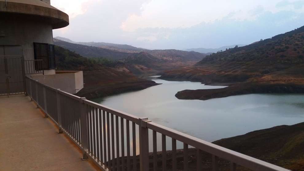
The dam Akaki-Malounta is another attraction of the area, offering uninterrupted views of the surrounding landscape with its deep ravines and the lake it creates.
The rural settlement of Fikardou (04/02/2002) Phicardou. A traditional rural settlement in a mountain environment with architecture preserved from the 18th and 19th centuries.
This tiny village church is called the Church of the Apostles, St Peter and St Paul. I ate at a small restaurant and had delicious dolmades.
Machairas Monastery Nikitari. This lovely church has great wood columns, beams and ceilings, frescoes on the upper walls, a lovely bright iconostasis with gild, reds, and greens, carved pews, a great bishop’s chair, and mosaics on the outside walls.
At another entrance is a small park with a large statue of a man holding binoculars and a gun beside a large eagle.
Macheras National Forest Park. A pine forest surrounds the monastery.
Kionia (04/02/2002) Makheras is the secondary peak below a large radar dome on the real peak. I had a nap below it and a short trail leads to the top with a cross. It is an example of a sheeted dyke complex that allows studies of the spreading hydrothermal alteration of the oceanic crust.
There are many viewpoints here to see the entire west and south of the island – from Nicosia to Limossa.
Pano Lefkara. A NM small town.
Dipotamos Reservoir. The Dipotamos dam was built in 1985 providing a water storage volume of 15,500,000 cubic metres. Two rivers connect at the Dipotamos area, east of the village of Skarinou, and form the river Pentaschoinos. At the point of junction of the two rivers, the dam was built to irrigate the valley of Pentaschoinos with 2800 plots of agricultural land.
The best route to reach the dam is from the Limassol – Nicosia motorway taking the exit to Skarinou village. Watch for the second right turn using a GPS location. The road becomes a dirt road after the Golden Donkeys Farm.
 The river is home to 8 species of fish, Kounoupieris, Loussippera, Kokkinopetra, Lavraki, Catfish, Carp, Helicopter, and Tilapia but fishing is not allowed! Penalties are huge – €8500.
Day 8
Gouverneur Beach. A small dark sand beach below a couple of hotels. It is also very narrow accommodating only about 30 lounge chairs.
Choirokoitia WHS is an archaeological site dating from the Neolithic age known as one of the most important and best-preserved prehistoric sites of the eastern Mediterranean. Much of its importance lies in the evidence of an organized functional society in the form of a collective settlement, with surrounding fortifications for communal protection. The Neolithic aceramic period is represented by this settlement and around 20 other similar settlements spread throughout the island.
The settlement of Khirokitia is situated on the slope of a hill in the valley of the Maroni River, towards the southern coast of the island about 6 km from the sea. Subsistence methods practiced by its Neolithic inhabitants included farming crops, herding sheep and goats, and raising pigs. It is a closed village, cut off from the outside world, apart from by the river, by a strong wall of stones 2.5 m thick and 3 m at its highest preserved level. Access into the village was probably via several entry points through the wall. The buildings within this wall consist of round structures huddled close together. The lower parts of these buildings are often of stone and attain massive proportions by constant additions of further skins of stones. Their external diameter varies between 2.3 m and 9.20 m while the internal diameter is only between 1.4 m and 4.80 m. A collapsed flat roof of one building found recently indicates that not all roofs were dome-shaped as was originally believed.
It is believed that the huts were like rooms several of which were grouped around an open courtyard and together formed the home. The population of the village at any one time is thought not to have exceeded 300 to 600 inhabitants. The people were rather short – the men about 5′ 3″ on average and the women about 4′ 11″. Infant mortality was very high. On average adult men reached 35 years of age and women 33. The dead were buried in crouched positions just under the floors of the houses. In some instances provision was made for offerings, possibly indicating a form of Ancestor cult within the households. This, the earliest known culture in Cyprus, consisted of a well-organized, developed society mainly engaged in farming, hunting, and herding. Farming was mainly of cereal crops. They also picked the fruit of trees growing wild in the surrounding area such as pistachio nuts, figs, olives, and prunes. The four main species of animals whose remains were found on the site were deer, sheep, goats, and pigs.
The village of Choirokoitia was suddenly abandoned for reasons unknown at around 6000 BC and it seems that the island remained uninhabited for about 1500 years until the next recorded entity, the Sotira group. More recent discoveries, however, including several sites in the vicinity of the ancient acropolis of Amathus on the eastern edge of modern Limassol, have filled this chronological gap considerably, revealing that the island was probably occupied continuously at least from the ninth millennium BC. Early communities were small and widely dispersed, so not every region would have been as heavily exploited as later in prehistory.
Klimonas archaeological site. This is a Neolithic site dating from 11,000 to 10,500 years ago. It had houses, 3-6 m across surrounding a 10 m wide central building built using wood beams. It was one of the sites of the earliest agriculture in the world cereals. They had dogs and cats.
This was impossible to find and I searched the supposed area for half an hour. At the Archaeological Museum in Lamossa, there were 11 tiny artifacts including some fling arrowheads. The archaeologist stated that the site could not be visited and was unwilling to give me the location.
LIMASSOL
The Oval. In the NM Architectural Delights series, this is a unique skyscraper, completely oval with brushed aluminum sides. Each floor has a balcony and there is a garden wall on the bottom.
It is a commercial-use high-rise building that opened in 2017. With 16 stories, it is 75 metres (246 ft) tall and the tallest office building in Cyprus.
Due to its complex geometrical shape, the project was realized through an advanced computational framework that was purposely built to support multiple levels and disciplines of design, construction, and digital fabrication. The Doubly Curved Shell is constructed of a Reinforced Concrete structure in combination with a steel frame and it is clad with around 10,000 different CNC fabricated aluminum panels.

Limassol Archaeology Museum. This is a great museum starting in the Neolithic period and ending in Roman times. Cyprus had great pottery in complex shapes and designs. A large exhibit is about Amathious. Free
The rest of the day was business. I had a free haircut (a trim of the fuzz around my neck), sorted out problems with my computer, and went out for dinner with Dani, a friend from Vancouver.
Day 9
Kollssi Castle is a former Crusader stronghold on the southwest edge of Kolossi village 14 kilometres (9 mi) west of Limassol on the island of Cyprus. It held great strategic importance in the Middle Ages and contained large facilities for the production of sugar from the local sugarcane, one of Cyprus’s main exports in the period. The original castle was possibly built in 1210 by the Frankish military when the land of Kolossi was given by King Hugh I to the Knights of the Order of St John of Jerusalem (Hospitallers).
The present castle was built in 1454 by the Hospitallers. Owing to rivalry among the factions in the Crusader Kingdom of Cyprus, the castle was taken by the Knights Templar in 1306 but returned to the Hospitallers in 1313 following the abolition of the Templars.
The castle today consists of a single three-story keep with an attached rectangular enclosure or bailey about 30 by 40 metres (98 by 131 ft).
As well as for its sugar, the area is also known for its sweet wine, Commandaria. At the wedding banquet after King Richard the Lionheart’s marriage to Berengaria of Navarre at nearby Limassol, he allegedly declared it to be the “wine of kings and the king of wines.” It has been produced in the region for millennia and is thought to be the oldest co
My Mall. This is a large 3-story mall in west Limassol. It has all the usual stores but a rather small food court. I ate at a fish restaurant.
CYPRUS – SOVEREIGN BBA (UK) – Akrotiri and Dhekelia
Day 9
Two separate areas in Cyprus are British. The first is on the east end and is crossed to get to Xylotymvou and Ormydeia and then (without knowing you are even there on the way to Ayia Napa).
The second lies to the west of the city of Limassol and again there are no visible boundaries or markers that one is even entering a different area.
Episkopi Beach. Drive down a rough 400 m road and park at the top of the cliffs. Follow a long descending road to two beaches that don’t look like they are used much.
Ancient Kourion was an important ancient city-state on the southwestern coast of Cyprus. In the twelfth century BCE, after the collapse of the Mycenaean palaces, Greek settlers from Argos arrived on this site. In the seventeenth century, Kourion suffered from five heavy earthquakes, but the city was partly rebuilt. The acropolis of Kourion, located 1.3 km southwest of Episkopi and 13 km west of Limassol, is located atop a limestone promontory nearly 100 metres high along the coast of Episkopi Bay. The Kourion archaeological area lies within the British Overseas Territory of Akrotiri and Dhekelia and is managed by the Cyprus Department of Antiquity.
There were signs on the highway but no ruins could be found. Kourion Beach is backed by several restaurants.
Limassol Salt Lake is the largest inland body of water in Cyprus, in Akrotiri and Dhekelia, United Kingdom, an overseas territory. It lies due south-west of the sprawling city of Limassol and measures 10.65 km2. Its lowest point is 2.7 meters below sea level and at its deepest point, the water depth measures about one meter. Geologists hypothesize the lake was formed over the gradual joining of an offshore islet off the southern coast of Cyprus.
The lake itself is considered to be one of the eastern Mediterranean region’s most important wetlands. The shallowness of the lake (more than half of the lake is less than 30 centimetres (12 in) deep) attracts thousands of wading birds to use it as a stopover during the migration seasons between Africa and Europe. BirdLife International estimates that between 2,000 and 20,000 greater flamingos (Phoenicopterus roseus) spend the winter months on the lake.
In 2003 the British Ministry of Defence caused some controversy by constructing two gigantic antennas as part of its radio listening post network in the Middle East.
On Thursday. Oct 21, I left the Lemongrass Hostel and drove to Nicosia.
Day 10
Stavrovouni Monastery is a Greek Orthodox monastery that stands on the top of a hill called Stavrovouni. The monastery is one of the few places where one can see a piece of the Holy Cross. Stavrovouni Monastery was founded by Saint Helena (Saint Constantine’s mother) in around 327–329 AD and therefore it is one of the oldest monasteries in the world. Stavrovouni, as the name already indicates, is dedicated to the Holy Cross; According to religious tradition, the monastery was founded by St. Helena, the mother of the Byzantine Emperor Constantine I, the Great. Helena went on a pilgrimage to the Holy Land when she discovered the three crosses on which Jesus and the two thieves had been crucified. She had them excavated and wanted to bring them to Constantinople, but she is said to have left one of these crosses in Cyprus during an involuntary visit caused by a shipwreck. Religious history says that the Holy Cross was transferred by a miracle to the peak of a high hill overnight and that a strong light was coming out of that peak. After several unsuccessful attempts to get the Holy Cross out of that mountain, Helena decided to leave a piece there and built a small chapel to accompany it.
Stavrovouni is therefore considered to be one of the oldest monasteries in the world; other ancient monasteries are Saint Athanasius (344), Saint Anthony (356), Saint Macarius (360), Saint Gabriel (Mor Gabriel) (397), Saint Euthymius (460), Saint Sabbas (Mar Saba) (483) and Saint Catherine, Sinai (565).
In its long history, Stavrovouni went through times of great poverty and hardship caused by the numerous invasions by foreigners on the island. Nowadays, the Holy Cross is no longer there and nobody knows what has happened to it. The walls, the church, the iconostasis, and the monks’ cells in Stavrovouni were almost completely destroyed during a great fire in 1888. The only relic which has been preserved down to the present is a silver cross in which a minute piece of the Holy Cross is inserted, the only major reliquary which is still kept in Stavrovouni.
The monastery had no monks for a period roughly between the 16th and the 19th centuries, a time when the Turks ruled the island. At the end of the 19th century, Elder Dionysios A’ moved to Stavrovouni from Mount Athos in 1889, and the monastery was in operation again.
The monastery grew larger and larger and soon became the spiritual center of the island of Cyprus.
High on a hill, it gives commanding views of the entire east side of the island from
Larnaca to Nicosia. The monastery is basically closed and has high security with razor wire to prevent access.
There are many interesting signs on the outside door: They are protesting two quarries and an asphalt plant nearby. Nothing is allowed inside: from phones to waist packs – and even women.
Mathiatis South (04/02/2002). A 90-million-year-old exposed fragment of the oceanic crust that has been exceptionally well preserved. It was an important mining site indicated by galleries and adits from Roman times.
Like the several Tentative WHS in Cyprus related to this same geological feature, none are marked so, and it is always difficult to know what they mean. South of Mathiatis is a rocky hill with exposed green-tinged rock. It comes down in the mountain in rows of thin sedimentary ridges. Nothing seems to grow on it.
Akincilar. Google Maps tried to take me there from S Cyprus but it is on the other side of the Buffer
A zone in a narrow peninsula of land enclosed by a buffer zone. It can only be accessed from this side by the UN. I met a UN truck on the tiny potholed road. Both soldiers were from Slovakia. They said that about 100 people (mostly old) live there.
It was a long drive around to the east side of the “peninsula”.
NICOSIA/LEFKOSA
Stelios Ioannou Learning Resource Center. In the NM Architectural Delights series, this building is on the university campus. From the outside, it is covered with an opaque green screen with a white dome projecting up. The dome is the center of the 3-story library and a white cone that tapers to a spike projects up into it. It is surrounded by 3-stories of classrooms, multimedia rooms and production studios, and several cafeterias on the bottom floor. All is reinforced concrete.
Day 11
NICOSIA/LEFKOSA
Liberty Monument. Erected in 1973 to honour those who fought in the 1955-50 struggle to liberate Cyprus. In 1987, EOKA fighters were added. It is a large marble platform with 14 bronze figures exiting a jail, 2 men pulling on chains to raise the cell door and a woman representing liberty on the top.
Makarios statue. Fronting the new (1960s) Archbishop Palace, this is an 8’ tall white marble statue of Archbishop Makarios
Ethnological Museum (The Hakjigeorgakis Kornesios Mansion). He lived from 1779-1807 and was killed (throat cut) as he had amassed too much power as the dragoman (tax collector). It is a wonderful house dating to the 18th century. The highlights are the reception room (great ceiling) a 1750 grandfather clock and more decorative ceilings. Free
Cyprus Folk Art Museum. In the old Archbishops Palace dating to the 15th century, it has mostly Turkish items: weaving, pottery, embroidery, leather, painting and agricultural items. 2€
National Struggle Museum. Since the 14th century, Cyprus has been Greek but has been dominated by the Ottomans 1571-1878 and then the British (who fought on the Allied side in both World Wars). 78% wanted to be independent (14% Turkish and 4% others) but then had to fight the war from 1955-59 to become independent. Pyla Concentration camp is well shown. Free
Byzantine Museum. Has about 230 icons dating from the 9th to the 19th centuries, as well as other typical examples of the Byzantine art of Cyprus, such as sacred vessels, vestments, and books. The collection includes many icons dating from the 12th century when iconography was at its height. The highlight is the famous 6th-century mosaics torn from the church of Kanakaria in the occupied area, sold abroad, and later repatriated.
Zanettos Tavern. In the NM Hospitality Legends series, this has been serving traditional Cypriot meze since 1938. Still relatively small, the restaurant has doubled in size since then. In the evening the terrace at the back is best. Photos of the owner with famous artists decorate the walls. This is a typical meze place, you order drinks and the food is a surprise coming little by little – starters, mains, side dishes and finally desserts.
The Cyprus Museum. A huge archaeological collection from Neolithic to Roman. Many pots and statues. Free
Leventis Gallery. An art gallery divided into Greek, Paris and Cyprus collections.
Leventis Municipal Museum of Nicosia. An ethnographic museum with a wide range of typical Cyprus clothing, jewelry and art. An exhibit on the Leda Palace Hotel Free
Tower 25. In the NM Architectural Delights series, it is 63m high, has 18 floors and was built in 2013 when it was the tallest in Nicosia (replaced by Tower 360). It is pure white with mostly small square windows and a long balcony across the front.
Day 12
Nicosia Flea Market (Saturday). Google Maps did not help me find this and I wonder if it still exists? Nobody in the area knew of it and I came on a Saturday.
Wargaming HQ. A 13-story skyscraper of black glass with an oval front.
Wargaming is a Belarusian video game company headquartered in Nicosia, Cyprus. The group operates across more than 20 offices globally and development studios, the largest of which is located in Minsk, where the company originated from. Initially focused on turn-based strategy and real-time strategy games, Wargaming switched to developing free-to-play online action games in 2009, including the military-themed team-based game World of Tanks, and later World of Warships and World of Warplanes.
In 2011, Wargaming relocated its headquarters from Minsk to Nicosia, Cyprus. Since 17 August 2015, these headquarters are located in the Wargaming HQ building, formerly known as the President building,
In 2012, Wargaming’s revenue was declared to be 217.9 million euros, with a net profit of 6.1 million Euros. In November 2020, the Cypriot government announced an investigation into possible passport fraud, where Wargaming employees were granted “Golden Passports” (faster Cypriot citizenship in exchange for monetary investments in the country) on fraudulent grounds. 27 of them were found to be not compliant with the program’s criteria, including having filled in fake addresses assigned to parking lots, and empty land.

Melios Zoo. Hundreds of very pretty birds in the Pet Centre. An array of single animals from camels to emus. Not so interesting. 5€
Agioi Varnavas and Ilarion at Peristerona (Five-domed churches) Tentative WHS (02/02/2004). Along with the church of Agia Paraskevi of Geroskipou, they constitute the only five-domed churches of Cyprus. The church of Agios Varnavas and Ilarionas, is dated to the end of the 11th – beginning of the 12th century. It is quite possible that it replaced an earlier church, which probably belonged to the type of the three-aisled, barrel-vaulted basilica. In 1959, during the course of restricted excavation work in the church’s interior, a semi-circular synthronon was found within the apse, along with the base of a templon screen. Part of the original church’s north wall still survives, incorporated in the western part of the wall of the existing church.
The church belongs to the type of three-aisled, barrel-vaulted basilica. The nave has three domes. In the centre of the side aisles, the semi-cylindrical vault is interrupted by a smaller dome, which touches upon the sides of the central dome of the nave. Thus, seen from above, a cross-shaped plan on the roof of the church is formed.
The narthex is a later addition with contemporary repairs. The church’s belfry was built in the 19th century. The oldest wall-painting samples belong to the 15th and 16th century. The 16th-century altar-doors of the iconostasis also survive. The plaster fragments of the templon screen belonging to the church’s first architectural phase, dated to the Middle Byzantine period, are on display in the narthex.
Saints Barnabas and Hilarion lived between 408-450BC and were from Cappadoccia in the Byzantine army. When they learned of Christ, they adopted the Orhtodox religion, sold all their belongings, became ascetics and died in old age. Their relics mysteriously appeared in Cyprus, were found and brought to Peristeronas and a church was built. The relics are now kept in a silver case and are visited with a celebration day on October 21.
The church was renovated in 2005 with all the plaster removed to show the ancient stonework and it appeared that the inside was entirely painted.
There are phone numbers to call to open the church and the man in the coffee shop next door called. The old man came promptly and opened the church just for me.
The iconostasis is ancient carved wood with a blue background and embroidered cloths hanging along the bottom. Unusually there are over 200 chairs in addition to the tall chairs on the sides. Two great chandeliers, 4 tall brass candle holders and many candelaria complete the inside.
