
France – Poitou-Charentes (Poitiers, La Rochelle, Niort) September 13, 2021
ROCHEFORT
Rochefort-Martrou Transporter Bridge was built between 1898 and 1900. It connects the towns of Rochefort and Échillais without hindering the navigation of shipping serving the ports of Rochefort and Tonnay-Charente. It is the last transporter bridge in operation in France. Crossing the Charente River, it has a maximum height of 66.5 metres (218 ft) and a total length of 175.5 metres (576 ft). It is a technical invention accomplished by the French engineer Ferdinand Arnodin. It was abandoned in 1967 in favour of a vertical lift bridge, (through its classification as a historical monument, it avoided destruction) which was in turn demolished in 1991 a few months after the opening of a new dual-carriageway road bridge, the Martrou viaduct. However, the transporter bridge was refurbished by 1994 and is now a historical monument (1976) Crossing on foot or by bicycle or moped is still possible today from April to the end of October. Crossings last 75 seconds, excluding boarding and disembarking time.
Arsenal de Rochefort et fortifications de l’estuaire de la Charente Tentative WHS (01/02/2002), Rochefort. Created in 1666 by Louis XIV on the advice of Colbert, to provide the Atlantic coast of France with a secure maritime base, the arsenal of Rochefort, which has monuments as prestigious as the royal rope factory (designed by Blondel), or the refit basins, is located 24 km away from the sea, following the course of the Charente, in order to protect itself from an enemy landing. The city which was built according to a regular grid plan, near and without ever merging with the arsenal, was in turn included in an enclosure completed in 1690. The defense of the arsenal was to be ensured by the fortification of the arsenal. Pertuis and in particular the Ile d’Aix, the only point to be able to guarantee the defense of the harbor.
It all started with Vauban, who was to initiate a “ring of fire” to defend the mouth of the Charente and the Arsenal de Rochefort. This “ Route des Forts ” will be made up of the “stone soldiers” of Rochefort Océan: Fort Vauban, Fort Liédot, Fort Boyard …
Each fort has its own history and role: Fort Lupine protects the Royal Lupine Fountain and the ships coming from the Rochefort Arsenal and those going up the Charente river, Fort Vauban monitors the mouth of the river between Fouras-les -Bains and Port-des-Barques, Fort de la Rade and Fort Liédot defend the island of Aix. The Fort Enet plays the role of sentinel between Fouras-les-Bains and the island of Aix and the Fort of the island Madame gendarme the harbor of the island.
At the end of 360 km of meanders, the Charente flows into the Atlantic Ocean, between Fouras and Port-des-Barques. At high tide, one has the impression of seeing the freighters sailing through fields. As in the song, they come from the end of the world to reach the commercial ports of Rochefort and Tonnay-Charente. Until the 19th century, the Charente was one of the main commercial axes of the Pays Rochefortais. The transport of wine and spirits, in particular to Northern Europe, is the basis of a flourishing economy. From the 17th century, the presence of the Charente proved to be a determining element in the choice of Louis XIV, who decided to build in Rochefort “the most beautiful and the largest Arsenal” of his kingdom. The Corderie Royale stretches 374 m in length along the river. The threats of invasion gave rise to a whole system of fortifications, spread over the whole country, still visible today.
Musée National de la Marine. Inside the fort, it is a typical marine museum.
OLERON ISLAND is an island off the Atlantic on the southern side of the Pertuis d’Antioche strait. It is the second-largest island of Metropolitan France, after Corsica, with a length of 30 km and a width of 8 km. It has an area of 174 km2 and more than 21,000 permanent inhabitants.
During the Second World War, the island was occupied by German forces and fortified. It was liberated by Free French Forces in an amphibious assault code-named Operation Jupiter on 29 April 1945. The French cruiser Duquesne fired 550 heavy shells at the German artillery batteries. The garrison surrendered on the following day.
It is a fertile and well-cultivated island on the Atlantic coast of France, that is on the Bay of Biscay. The climate is generally mild (maritime temperate) with sufficient but not excessive rainfall.
Since 1966, the island has been connected to the mainland by a road bridge. With a length of 2,862 m (9,390 ft) between abutments, it was the longest bridge in France at the time of construction. It is now the third one, after the Saint-Nazaire bridge and the Île de Ré bridge. It has been toll-free since 1991. The port towns are frequently visited by tourists, especially the village of La Cotiniere.
This very flat island has extensive unattractive mudflats surrounding most of it at low tide.
Phare de Chassiron, Saint-Denis-d’Oléron. On the NW end of Oleron, this black and white LH was built in 1836 and has ornamental gardens and a museum. The lighthouse allows sailors to enter the waters of the Antioch sluice, a place strewn with reefs and famous for its many shipwrecks. It is the oldest lighthouse in France still active after that of Cordouan. Height: 43 meters. Range of approximately 52 km (28 nautical miles), Number of steps: 224
Fort Louvois, Bourcefranc-le-Chapus. Between the mainland and Oleron Island, this 17th-centurydd island fortress had a lighthouse on the top of the keep. Built between 1691 and 1694, during the reign of Louis XIV, on the Chapus islet, and is about 400 metres (1,300 ft) offshore in the town of Bourcefranc-le-Chapus and sits opposite the citadel of Château d’Oléron on the island of Oléron. The fort was positioned so that a crossfire from the château and the fort would control the Pertuis de Maumusson (Passage of Maumusson) and impede access to the Rochefort roads from the south. Fort Louvois only saw action towards the end of World War II when bombardment greatly damaged the fort, necessitating later restoration.
Since 1972 the fort has been the site of a museum of oyster farming, and there are oyster beds next to the causeway that joins the fort to the shore. The fort also houses a permanent exhibition that describes the history of the fort and that contains models of fortifications on the Charente coast. During the summer a shuttle boat that operates during high tide takes visitors to the fort; at low tide, the fort is accessible via a causeway.
LA ROCHELLE
Le Bunker is a museum on the Second World War, which deals with the occupation of the city of La Rochelle and its surroundings between 1939 and 1945. This museum is an original former bunker built during the war of 39-45 to house the commanders of the U-Boote whose submarines were stationed in the La Rochelle submarine base.
It is 280 m ² with protective walls of 2m reinforced concrete. It has two large rooms for a total of 62 officers and six individual rooms, notably for two admirals, a large bar, an office, a technical room, and toilets.
The city of La Rochelle will know about 350 air alerts from until , the shelter was therefore used a lot.
Plage De la Concurrence. A small beach between two breakwaters.
Lantern Tower is one of the three medieval historic towers in La Rochelle which guarded the port at Aunis. The Lantern tower served as a Lighthouse and prison throughout its history. 8E
ÎLE DE RE is an island off the west coast near La Rochelle, on the northern side of the Pertuis d’Antioche strait. Its highest point has an elevation of 20 metres (66 feet). It is 30 kilometres (19 miles) long and five kilometres (3 miles) wide.
The 2.9 km (1.8 mi) Île de Ré bridge, completed in 1988, connects it to La Rochelle on the mainland. Since then, tourism on the island has developed considerably, with real estate prices reaching high levels. The easier transportation system has stimulated the purchase of holiday homes by people from as far as Paris, who can visit for weekends, mostly in spring and summer. Using the bridge requires the payment of a toll (either €8 or €16 return for a normal car and makes it the most expensive road to use per kilometre in France.
Fort de la Pree, La Flotte was built in 1625, is located near the eastern end of the Île de Ré.
The Duke of Buckingham ignored Fort de La Prée during his three-month siege of Saint-Martin-de-Ré in 1627. This neglect fatally weakened his position on the island. Toiras managed to land troops there, and from there force the English to give up their siege and withdraw in defeat.
Phares des Baleines, Saint-Clément-des-Baleines is located at the western tip of the island. The lighthouse owes its name to the fact that a relatively large number of whales washed up at this place on the Ile de Ré in the past. It succeeds the old Baleines lighthouse built by Vauban.
It was built, in 1849 to replace the old 29-meter lighthouse built-in 1682 on the instructions of Vauban and which still exists today north of the lighthouse. The lighthouse is 57 meters high and access to the summit is via a spiral staircase of 257 steps. The great lighthouse from 1854 is still active and its light has a range of about 50 kilometers. It is visited by 160,000 visitors each year.
Since 2007, a museum dedicated to lighthouses and beacons has been created in this former building of the school of lighthouse keepers at the foot of the old tower.
France – Pays-de-la-Loire (Nantes, Angers, Le Mans, Saint-Nazaire) Sept 14, 2021
PAYS-DE-LOIRE
I only made one stop in this province to see a Bizzarium Series site.
Machines of the Isle of Nantes, Nantes is an artistic, touristic, and cultural project constructed in 2007 in the old covered buildings of the former shipyards in Nantes. They were created by two artists.
The Great Elephant is a mechanical elephant, 12m high and 8m wide, made from 45 tons of wood and steel. It can take up to 49 passengers for a 45-minute walk. It is an inexact replica of The Sultan’s Elephant from Royal de Luxe, which toured the world from 2005 to 2007; the main difference being that this elephant is designed to carry spectators.

The Marine Worlds Carousel made in 2012 is a huge carousel, rising nearly 25m high and measuring 20m in diameter. It features 35 moving underwater creatures on three levels: the ocean floor, the depths, and the sea and boats. Visitors will be able to move about amidst a ballet of aquatic animals and sea carriages, as well as climb aboard and guide the movements of the Machines.

The Heron Tree (2014) is a steel structure 45 meters in diameter and 28 meters in height, topped with two herons. The project plans to allow visitors to climb either onto the back or onto the wings of the birds for a circular flight over the hanging gardens of the tree.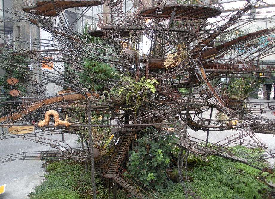 The Workshop is the site of fabrication for people to observe the ongoing building process. Today, the construction of the Marine Worlds occupies one part of the workshop.
———————————————————————————————————-
France – Bretagne (Rennes, Brest, Quimper) September 14-15, 2021
BRETAGNE
I drove through Bretagne via Nantes and Rennes to stay on the large freeways, on my way to St Malo to catch the Condor ferry to Jersey.
I had wanted to go to Musee Memoires 39-45 in Plougonvelin in the NM series The Dark Side and to Huelgoat Magical Forest in the NM series Bizzarium (my two favorites), but they were a long drive. I spent a long time at a rest stop outside of Nantes, drove in the dark to St Malo with the main freeway closed so all on slow secondary roads, and slept in St Malo to get the ferry at 07:30.
