
Madagascar June 7-15, 2023
Madagascar is the world’s fourth largest island, the second-largest island country and the 46th largest country in the world. Its capital and largest city is Antananarivo.
Madagascar consists of an eponymous main island and numerous smaller peripheral islands. Following the prehistoric breakup of the supercontinent Gondwana, Madagascar split from Africa during the Early Jurassic, around 180 million years ago, and split from the Indian subcontinent around 90 million years ago, allowing native plants and animals to evolve in relative isolation; consequently, it is a biodiversity hotspot and one of the world’s 17 megadiverse countries, with over 90% of wildlife being endemic. Madagascar’s varied plants and animals are endangered by human activity, as one-third of its native vegetation has disappeared since the 1970s and since the arrival of humans 2,000 years ago, Madagascar has lost more than 90% of its original forest. Most lemurs are listed as endangered or threatened species. The island has a subtropical to tropical maritime climate.
Madagascar was first settled during or before the mid first millennium AD by Austronesian peoples, presumably arriving on outrigger canoes from present-day Indonesia. These were joined around the ninth century AD by Bantu migrants crossing the Mozambique Channel from East Africa. Other groups continued to settle on Madagascar over time, each one making lasting contributions to Malagasy cultural life. Subsequently, the Malagasy ethnic group is often divided into 18 or more subgroups, of which the largest are the Merina of the central highlands.
Until the late 18th century, the island of Madagascar was ruled by a fragmented assortment of shifting sociopolitical alliances. Beginning in the early 19th century, most of it was united and ruled as the Kingdom of Madagascar by a series of Merina nobles. The Monarchy was ended in 1897 by the annexation by France, from which Madagascar gained independence in 1960. The country has since undergone four major constitutional periods, termed republics, and has been governed as a constitutional democracy since 1992. Following a political crisis and military coup in 2009, Madagascar underwent a protracted transition towards its fourth and current republic, with constitutional governance being restored in January 2014.
Madagascar is classified as a least developed country by the UN. Ecotourism and agriculture, paired with greater investments in education, health and private enterprise, are key elements of its development strategy. Despite substantial economic growth since the early 2000s, income disparities have widened, and quality of life remains low for the majority of the population. Madagascar is experiencing an ongoing famine, which experts argue is the first to be caused entirely by climate change.
The eastern, or windward side of the island is home to tropical rainforests, while the western and southern sides, which lie in the rain shadow of the central highlands, are home to tropical dry forests, thorn forests, and deserts and xeric shrub lands. Madagascar’s dry deciduous rainforest has been preserved generally better than the eastern rainforests or the high central plateau, presumably due to historically low population densities.
Capital. Antananarivo. 18°55′S 47°31′E
Official languages. Malagasy, French
Ethnic groups. 26% Merina, 15% Betsimisaraka, 12% Betsileo, 7% Tsimihety, 6% Sakalava, 5% Antaisaka, 5% Antandroy, 24% Others
Religions. 84.7% Christianity —45.8% Protestantism, —38.1% Catholicism, —0.8% Other Christian
7.3% No religion, 4.7% Traditional faiths, 3.1% Islam, 0.3% Others
Area. 587,041 km2 (226,658 sq mi) (46th). Water 5,501 km2 (2,124 sq mi) .9%
Population. 28,812,195 (52nd). Density 47.7/km2 (123.5/sq mi)
GDP (PPP). $51.8 billion (117th). Per capita. $1,790 (182nd)
GDP (Noominal). $15.10 billion (139th). Per capita. $522[9] (188th).
Gini. 42.6 medium
HDI. 0.501 low · 173rd
Currency. Ariary (MGA)
Driving Side. Right
Calling code. +261
Visa on Arrival – 15 days $10 cash, 35€ for more than 15 days. Visit the Visa counters on the right-hand side in the entry hall first. Fill out the online disembarkation card ahead of time to jump ahead in the queue.
Money. MAG (Malagasy Ariary). 1US$ = 4,416 MAG. 1€ = 4,730 MAG June 23
ATM in the airport. ATMs the best way to go but have cues. Euros necessary for car hire. Smaller places (e.g. Isalo, Andasibe) don’t have banks. Always bad rate (up to 8% worse) for Euros. Few take credit cards. MCB bank ATM have no withdrawal fee in Madagascar
SIM. Three companies in the airport. I bought Orange. Telma recommended with best coverage. Top up with scratchcards sold everywhere and dial #322*73# to activate. 4G good in Tana and Morondava and better than wifi.
Climate. The climate is tropical along the coast, temperate inland, and arid in the south. Madagascar has two seasons: a very hot, rainy season from November to April, and a cooler, dry season from May to October.
Transport.
Get There: From Addis, Joburg, Nairobi, and Paris (Air France). Reunion with Air Austral, Mayotte with Ewa Air to Mahajanga. Air-link from Johannesburg cheapest.
Get Around:
National road 7 (RN7) connects the city to Antananarivo in the north and to Fianarantsoa and Toliara to the south. Antsirabe is connected with Morondava on the west coast through RN34/35.
Driving is hectic, some roads are very bad, dusty and more pot-holes than road. Many roads are impassable (incl. to Tsingy) during the Nov-Apr rainy season.
Taxi Brousse. (9 seater Taxis) leave Antananarivo from the main bus station in the north of the city at 7am in a convoy for Fianarantsoa and other destinations from Tana. Very comfortable.
Cotisse Transport sells out quick, so book in advance – 18.891724918463805, 47.529060411643336 [email protected] or visit their office in Tana. Take to Antsirabe, Morondava (14-16 hours), so the 1 hour twice-weekly internal flight may be worth it.
Soa Trans is equally good (VIP buses).
Taxis. Try to overcharge bit check for the base price to get a realistic price. VTC taxi +261446940291 VTC taxi 51 000 MA from airport to Tana centre.
Small buses and rickshaws: pulled rickshaws (“pousse-pousse”), cycle rickshaw (“cyclo-pousse”), auto-rickshaw (“touktouks”)
Walking in Tana easy.
Motorbike in Antsirabe to Lake Tritriva and Morondava. $23 a day for the bike.
Plane: Tsaradia, a new domestic airline affiliate of Air Madagascar. Foreign credit cards are still not accepted for booking on the official Tsaradia website but can book on kiwi.com. Kiwi charges a 10%-ish markup. Thur, Sun for around $150. The Tsaradia hotline is easy to access (in three languages: Malagasy, French, and English) and can provide current flight information.
Recommend Tana to Nosy be and Morondava to Toliara (great). Reducing road travel is sensible. Internal flights aren’t bargains but they felt like one after 16 hours in a bus between Tana and Morondava.
Ramatours book Taxi brousse and flights on Tsaradia Airlines [email protected]– WhatsApp +261 34 20 254 97 or Francia on WhatsApp +261 32 55 047 18.
Cost: Inexpensive compared to central and western Africa. Nice hotels under 50 EUR. Food is inexpensive. A lot of rice + a small serving of vegetables or meat. Upmarket restaurants the food is delicious.
Safety. The people are very friendly and not aggressive. It is very easy to travel.
Wildlife Tour, +1 206.669.9272, Lemurs, Tortoise, Geckos, Chameleons and unusual flora. Roads are dismal and the minimal infrastructure makes it challenging for independent travellers. Apex Expeditions runs a pretty comprehensive wildlife safari.
Potential Itinerary for Madagascar. May 2022 (after the rainy season)
Tana (Region Antananarivo Center)
Morondava (Region Toliara West South). 16-17 hour bus from Tana, Avenue of the Baobabs, 12-hour bus to Tsingy (Region Mahajanga and Antsiranana West North). Return Morondava (MOQ)
Fly Isle St Marie (Region Toamsina)
Fly Fianarantsoa (Region Fianarantsoa).
Return Tana.
Fly Comoros
Day 1 Wed June 7
Flight. Johannesburg to Tana Air link @10:00-14:10
VOA very fast – simply paid €10 (with a dated 50 bill and given change). Get a half-page sticker. No requirements for an exit flight.
Used an ATB and withdrew 800,000. Orange SIM 2000 + 5 GB data for 15 days 43,000
Taxi from airport – metered taxis 70,000, bargained for 55,000. Stopped at the mosque on the way into town so gave him 60,000.
CENTER – REGION ANTANANARIVO (Antsirabe)
ANTANANARIVO (pop 1,275,207 2018, elevation 1,280m). Known by its colonial shorthand form Tana, is the capital and largest city of Madagascar. In the center of the island, it is the highest national capital by elevation among the island countries.
History. Historically the capital of the Merina people, who continue to form the majority. All eighteen Malagasy ethnic groups. It was founded circa 1610 when the Merina King Andrianjaka (1612–1630) expelled the Vazimba inhabitants of the village of Analamanga. Declaring it the site of his capital, Andrianjaka built a rova (fortified royal dwelling) that expanded to become the royal palaces of the Kingdom of Imerina. The city retained the name Analamanga until the reign of King Andriamasinavalona (1675–1710), who renamed it Antananarivo (“City of the Thousand”) in honour of Andrianjaka’s soldiers.
Antananarivo remained the island’s capital after Madagascar was colonized by the French in 1897, and after independence in 1960.
Limited funds and mismanagement have hampered consecutive CUA efforts to manage overcrowding and traffic, waste management, pollution, security, public water and electricity, and other challenges linked to explosive population growth.
There’s no point being kind about this – there is no tourist infrastructure to speak of in Antananarivo – for some that is part of the attraction!
Antananarivo Airport (TNR)
Food: Sakamanga is nice, Le Petite Brasserie has nicer dining.
Khoja Shia Ithnaashri Mosque. A wonderful mosque with a stunning facade of tiles and Koranic writing in a mihrab-shaped alcove. Two minarets with gold domes. Large central dome. The lower prayer hall was open but the upper one was closed. Saw on the way in from the airport.
ON Madagascar Underground. Dorm $10 Restaurant, bar for locals, great daily lunch sets for 7K. Average with hot shower.
Day 2 Thur June 8
Get around Tana. The traffic in town is terrible, mostly because there are so many van taxis that park anywhere, and go slowly as they are looking for passengers.
Taxis are expensive. Minivans cheapest but don’t leave till full and stop very frequently, hard to figure out routes. Moto taxis are my favourite, cheap, best to get through the bad traffic, and offer the ability to go to many destinations. Some are very small scooters so look for the larger bikes.
I used a moto taxi to go to the 27 km to Ambohimanga and stopped at two places. It was a tiny scooter and not so comfortable. Communication was difficult so used Google Translate a lot. 80,000 there and back to Cotisse.
Rova Antsahadinta. In the NM Vestiges of the Past, this is another palace, of King Radama II. It is a 2-story black plank building with many artifacts – game boards, household artifacts, and jewelry. It is a steep drive to the top of the hill.
Royal Hill of Ambohimanga WHS Ambohimanga is one of the twelve sacred hills 24 km NE of Antananarivo. It is the most significant monument of the precolonial Merina Kingdom. The walled historic village includes residences and burial sites of several key monarchs. It remains a place of worship to which pilgrims come from Madagascar and elsewhere.
King Andriamasinavalona (1675–1710) divided the Kingdom of Imerina into four quadrants which led to 77 years of civil war until 1793. The court was moved back to Antananarivo with Ambohimanga as the kingdom’s spiritual capital. Until French colonization of the kingdom and the exile of the royal family in 1897.
The royal compound on the hilltop is surrounded by a complex system of defensive ditches and stone walls and is accessed by 14 gateways, of which many were sealed by stone disc barriers.
Arrive at the base of the hill. Buy your ticket (10,000 MA). Walk approximately 500 up the paved road, pass several knick-knack shops and a restaurant, and climb more stairs at the end to arrive on a large flat courtyard. This is where the king received tributes. There is a heart-shaped stone where sacrifices were made.
Enter the palace compound surrounded by a white concrete wall topped by a black picket fence. Pass through a two-corner passage and pass the cattle pen. There is a black building made of huge planks and one center post. Displays of artifacts. What I supposed was the Queen’s residence is a two-story building with a bedroom and nice furniture on top with a passage to a lovely windowed viewing deck and panoramic views.
There are five small wood buildings, the tombs of several of the kings and above that the sacred pools, two water pools.
I walked back the 500 m to the entrance and returned to Tana. The cost of a moto taxi 80,000 MA.
Cotisse Transport. They are the most reliable bus line to get around Tana. Use MB Sprinter vans. I was let off from my long moto-taxi at Cotisse. The only way to book trips is in person – don’t answer the phone, the email address doesn’t work and the online website totally dysfunctional. Note that there is a booking office for Cotisse outside the Hotel Tripolitsa that is much more convenient than going all the way to the Cotisse main office.
Tana to Morondava. I was able to get the front window seat. Departs at 06:30, check-in at 06:00. 59,500 MA. 12-14 hours.
Soarano Train Station. A gorgeous colonial-style train station that hasn’t had passenger trains for years. The inside has been all renovated and ready for stores. Now only an optician is present. The outside lot is full of a market of tents selling food, clothes and knick-knacks.
Pirates Museum. On the fourth floor of the building, small, all writing in French, all about Ile St. Marie, the main pirate haven in Madagascar. 10,000 MA
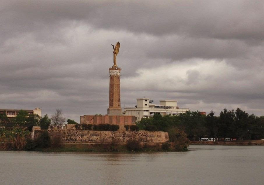
Monument to the Dead (Statue Madagascar). In the middle of Anosy Lake on the lower level of town. Connected by a good causeway whose entrance is blocked so can’t be accessed directly. Commemorates WWI soldiers.
Museum of Art and Archaeology. A small museum with more ethnography than archaeology. Not much of interest and all in French so I learned very little. Good that it was free!
All the following NM sites are up on the hill and involve a long climb. I took a moto taxi to the top and walked down.
Haute Ville d’Antananarivo. Tentative WHS (02/02/2016). In 1610, the palace built on the highest hill in the city – with a garrison of 1000 men. It is a fortified village, protected by circular ditches and accessed by seven megalithic gates. The city gradually developed to extend over the entire hill by the Merina ethnic group.
English Protestants and French Catholics struggled against the Merina monarchy and installed a diplomat in the city in 1885. Ten years later, French troops took possession of the island and drained the marshes and rice fields to create a new district – Avenue de l’Indépendance, grand staircases, many buildings (including the Soarano station), a sewer network, fountains, and electricity. The city had 140,000 inhabitants in 1940.
The Upper Town is home to the Rova (a set of palaces and royal buildings from different eras) with different styles of architecture – verandah or multi-storey dwellings, wooden, baked-brick or stone houses.
The site has kept several of its original squares, stairs, streets, and Rova de Antananarivo – the enclosure of the Royal Palace and the Queen’s Palace – visible from several kilometres around, and remains a major visual and architectural element defining the urban landscape of the city. Palace of the Prime Minister, Palace of Justice, Razafindrahety College, Vohipiraisana College,), its historic squares (Andohalo Square, Rasalama Square), its paths, streets and stairs (Rasalama corridor, canine street, etc.), its religious buildings (Protestant temple, Catholic church), the upper town constitutes a true testimony of the influence and the role played by royal architecture in the urban development of the city. Various Asian influences in Africa: square-type houses, Indonesian-type roofs, the important role of directions and orientation of buildings.Botanical and Zoological Garden of Tsimbazaza
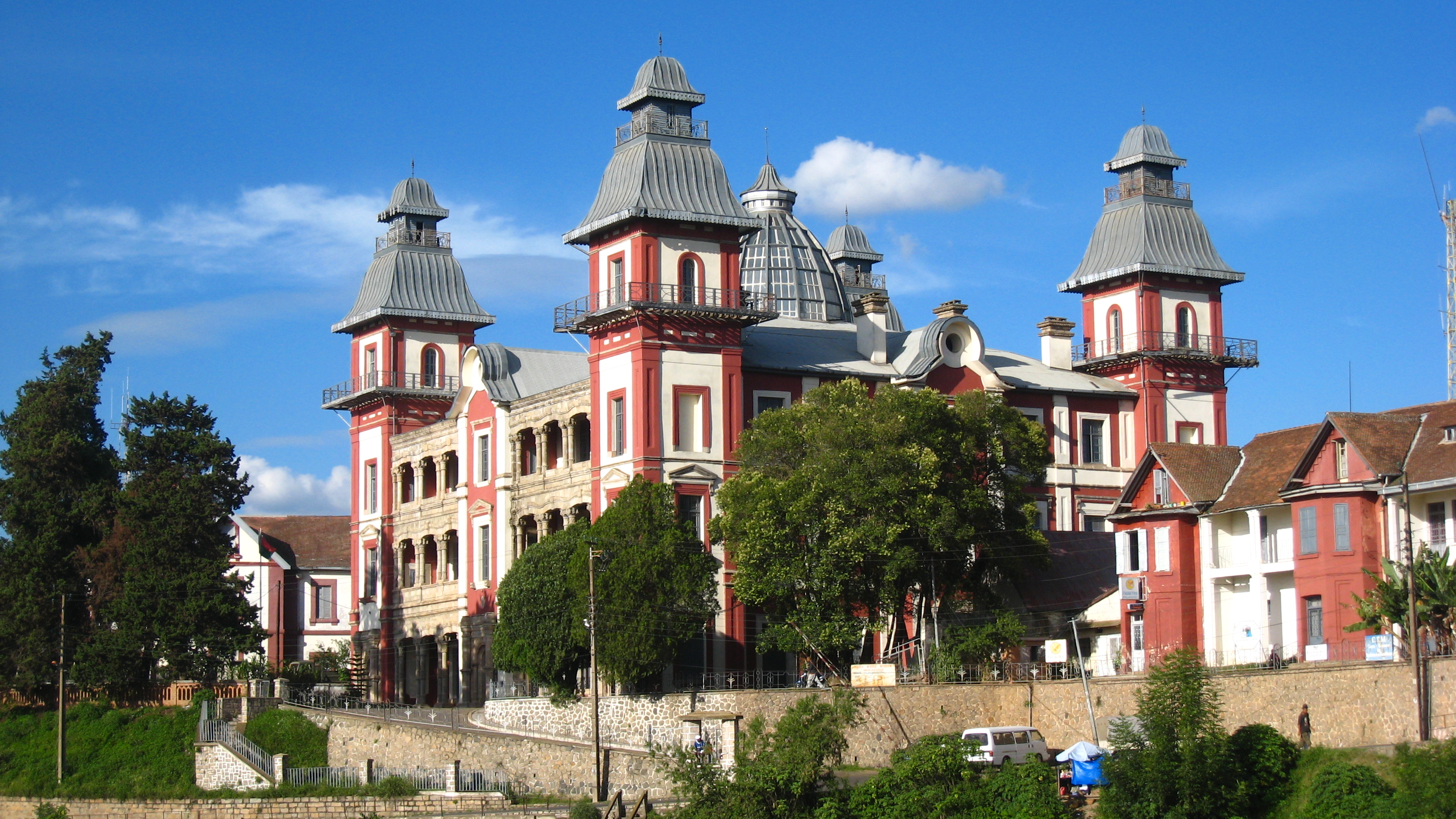
Rova of Antananarivo is a royal palace complex (rova) that served as the home of the sovereigns of the Kingdom of Imerina in the 17th and 18th centuries, as well as of the rulers of the Kingdom of Madagascar in the 19th century. Its counterpart is the nearby fortified village of Ambohimanga, which served as the spiritual seat of the kingdom in contrast to the political significance of the Rova in the capital. The Rova occupies the highest point on Analamanga, formerly the highest of Antananarivo’s many hills. Merina king Andrianjaka, who ruled Imerina from around 1610 until 1630, is believed to have captured Analamanga from a Vazimba king around 1610 or 1625 and erected the site’s first fortified royal structure. Successive Merina kings continued to rule from the site until the fall of the monarchy in 1896, frequently restoring, modifying or adding royal structures within the compound to suit their needs.
Over time, the number of buildings within the site varied. Andrianjaka founded the Rova with three buildings and a dedicated tomb site in the early 17th century. The number of structures rose to approximately twenty during the late 18th-century reign of King Andrianampoinimerina. By the late 20th century, the Rova’s structures had been reduced to eleven, representing various architectural styles and historical periods. The largest and most prominent of these was Manjakamiadana, also known as the “Queen’s Palace” after Queen Ranavalona I, for whom the original wooden palace was built between 1839 and 1841 by Frenchman Jean Laborde. In 1867 the palace was encased in stone for Queen Ranavalona II by Scotsman James Cameron, an artisan missionary of the London Missionary Society. The neighbouring Tranovola, a smaller wooden palace constructed in 1819 by Creole trader Louis Gros for King Radama I, was the first multi-story building with verandas in the Rova. The model offered by Tranovola transformed architecture throughout the highlands for the 19th century, inspiring a widespread shift toward two-storey houses with verandas. The Rova grounds also contained a cross-shaped wooden house (Manampisoa) built as the private residence of Queen Rasoherina, a stone Protestant chapel (Fiangonana), nine royal tombs, and several named wooden houses built in the traditional style reserved for the andriana (nobles) in Imerina. Among the most significant of these were Besakana, erected in the early 17th century by Andrianjaka and considered the throne of the kingdom, and Mahitsielafanjaka, a later building which came to represent the seat of ancestral spiritual authority at the Rova.
A fire on the night of 6 November 1995 destroyed or damaged all the structures within the Rova complex shortly before it was due to be inscribed on the list of UNESCO World Heritage Sites. Although officially declared an accident, rumours persist that politically motivated arson may have been the actual cause of the fire. The chapel and tombs, as well as Besakana and Mahitsielafanjaka, have since been fully restored. Completion of the reconstruction of the Manjakamiadana exterior was estimated for 2012, but was still no complete when I was there in 2023. The Queen’s palace cannot be entered. The only way to see much is to walk around the north, east and west sides (the south side is a cliff) and has great views of all of Tana. A new concrete “Colosseum” was built at the Queen’s Palace and is visible from below along with the lovely church.

Andafiavaratra Palace. Also closed for renovations, this was the residence of Prime Minister Rainilaiarivony of Madagascar, who governed the island kingdom in the late 19th century. The building currently serves as a museum and the estimated 1,466 objects of historical importance to the Kingdom of Madagascar that were rescued from the 1995 fire at the Rova of Antananarivo are housed here.
Musée De La Photographie De Madagascar. Contains digitalized and original photos from 1860m to 1960. Many cameras are on the walls at the entrance. There are three film rooms, each showing two films in three languages. The main gallery on the 2nd floor was all about the lamba, a large silk or cotton “shawl” thrown generally around the shoulders like a blanket. Different styles indicate gender or social category. Of importance, they must never be dirty. 20,000 MA
Getting here was an interesting series of stairs and tiny lanes.
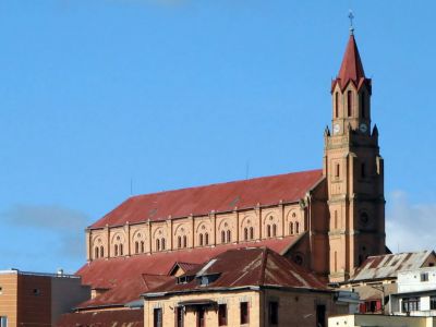
Cathédrale d’Andohalo (Cathedral of the Immaculate Conception of Antananarivo) is a Catholic cathedral in the upper town. Built on the site of a modest chapel, construction was from 1873, then declared a “classified historical monument” in January 1964. It was closed but the security guard at the front gate opened it up for me. It is a lovely grey stone with 5 pointed arches on each side. The Ways of the Cross are oil painting.
Faravohitra Church (FJKM Tranovato Faravohitra) is a Roman Catholic Church built in 1870 by architect Cameron. The building was dedicated to John the Baptist. It is located in the Haut-Ville. Built-in terracotta brick, the church bears Romanesque features, especially noting the arched windows, and it is remarkable from a distance for its high-gabled bell tower, decorated by clocks on either side of it. It is another significant climb up stairs and then streets.
Pavillion Analakely. This is a large market complex of long narrow buildings with hip roofs and red tiles. Each side has about 15 shops, mostly clothes, but also electronics and knick-knacks.
I ate at a small restaurant on the way down from the cathedral having a great Cordon Bleu with mashed potatoes (18,000 ~$4).
ON Madagascar Underground for a second night.
Day 3 Tue June 9
I was up at 4 am, shower was cold so skipped, had BF and caught an arranged moto taxi (25,000, a very high price but the kid was on time and efficient) to Cotisse Bus station for the long drive to Morondava (Check-in 6 am, depart 06:30, 59,500 MA, 17 hours, 698 km). The buses are Mercedes Benz Sprinters with 18 passengers. Luggage is well secured on the roof. I have the right front seat, the best in the house, but also unfortunately in the sun the whole way.
On our way out of Tana, the van followed a rough dirt road beside a canal lined on one side with decrepit corrugated/wood pole shacks. I have never seen a worse body of water – heaps of old garbage floating in rafts, a blue colour, bubbles of gas percolating up.
The first 9 hours were on narrow 2-lane pavement with moderate potholes. Bullock carts, human-powered freight carts, bicycles, bicycle freight (charcoal, fodder), large trucks and the many van taxis all make driving slow – in addition to all the potholes. The countryside is hilly with rice paddies at the bottom of the valleys, terraces extending to the top of the hills and frequent small villages. This is a hard life as all the agriculture is labour intensive – everyone seems to have a shovel – digging up the rice paddies. Produce selling on the side of the road is common – carrots, potatoes, cabbage. The typical house is tall narrow 2-story brick homes. Deforestation is extreme.
ANTSIRABE (pop 238,478 2013). The third largest city in Madagascar, cool climate, industry and many pulled rickshaws or pousse-pousse. Altitude of 1,500 m (4,900 ft), with a subtropical highland climate. In winter the temperature can fall below 0 °C (32 °F) at night.
Originally a farming region, the city was founded by Norwegian missionary T.G. Rosaas in 1872 as a hill station and in 1886 the leper hospital of Ambohipiantrana with 950 people in 1904.
Buildings include the thermal bath centre (1917), Hôtel des Thermes (1922), the railway station (1923), and the residence for French retirees (1934). Other sights are the Stele of Independence) on Independence Avenue and the two public markets: Antsenakely (“The Small Market”) and the bigger Asabotsy.
We stopped in Antsirabe for 10 minutes at about 11:20 and it seemed forever to finally leave it.
I didn’t see
The Ankaratra volcanic field covers an area about 100 km long from Antsirabe northwards to Arivonimamo where the highest peak reaches 2,644 m (8,675 ft). Several water-filled craters include Lake Tritriva to the southwest. There are hot springs at Ranomafana
4-7h drive from Tana, visit Lemur Island (before closure at 17), night Safari walk.
Antsirabe Cathedral. (Our Lady of La Salette Cathedral) Catholic built in 1908 and replaced in 1925-31 – 60m long, 16.77 wide, 14 high, bell tower 45m high. Fahaleovantena Tribes Monument.
The last half of the 17-hour drive was through a quite different country – much drier, more wide open vistas and higher but treeless hills. The road was good in places but then deteriorated to a mess of potholes. The villages were very poor with no electricity at night. We finally arrived at Morondava at 23:30 for a 17-hour drive.
TOLIARA (West South)
The only place I went to in this region of Madagascar was Morondava and the Avenue of the Baobabs.
Morondava. Chill out town that could be used as a base to unwind for a day or two. Nice beaches, colourful markets, and some cool street art. Belo sur Mer is a lovely coastal village nearby. Airport Morondava MOQ (Tsaradia to/from Morondava Thur, Sun for around $150)
16 hour drive from Antananarivo
I slept in till 7:30 missing the 7 am meeting and the convoy necessary to join to go to the Tzingy. So I spent a welcome day of rest and a chance to make arrangements to see the rest of Madagascar, specifically to figure out the flights on the Air Madagascar domestic airline Tsaradia.
All the flights out of Morondava are booked out till June 25! so I guess I will be taking Cotisse back.
Day 5 Sun June 11
I was not able to get to sleep (I never have insomnia) so simply didn’t go to sleep as I was scared that I would miss my trip for 2 days in a row. I was picked up by my guide at 06:30.
At 6:20, there was a guy from Argentina who was looking to go to the Tsingy, and I was happy to oblige him. He phoned Tsiky Tours and joined. Their response was unusual in that he was to pay me (despite possibly staying in separate hotel rooms), so my trip price was just cut in half.
Ariel is a nice, smart guy, an engineer who lives in Ushaia and runs a family business bottling Patagonian water from a natural spring. We talked a lot about the desperate situation of the Argentinian economy (the official rate to the US$ is 270 and the black market rate is 560, inflation is over 100%). He finds travel expensive but has two bank accounts, one for pesos and one for dollars.
Along a 260 m (850 ft) stretch of the road is a grove of 20–25 Adansonia grandidieri baobabs. An additional 25 or so trees of this species are found growing over nearby rice paddies and meadows within 9.9 acres (4 ha) of land. The trees, which are endemic to Madagascar, are about 30 m (98 ft) in height.
The baobab trees, known locally as renala or reniala (from Malagasy reny ala “mother of the forest”), are up to 2,800 years old. They are a legacy of the dense tropical forests that once thrived in Madagascar. The trees did not originally tower in isolation over the sere landscape of scrub but stood in dense forest. Over the years, as the country’s population grew, the forests were cleared for agriculture, leaving only the baobab trees, which the locals preserved as much for their own sake as for their value as a food source and building material.

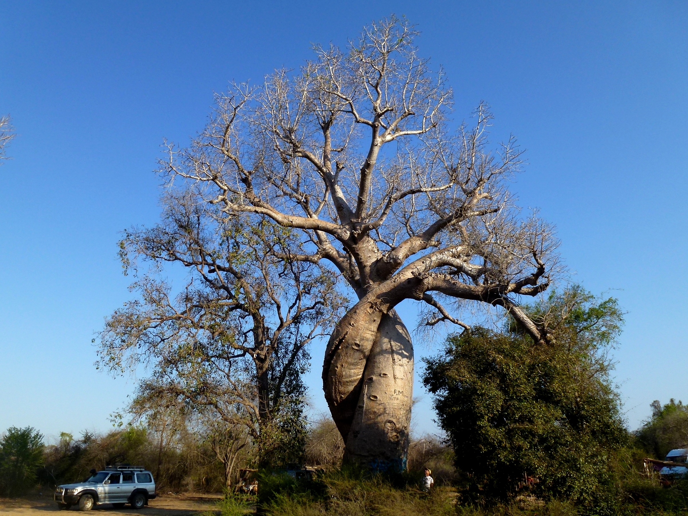
Baobab Amoureux. Some 7 km (4.3 mi) to the northwest are the Baobab Amoureux, which are two notable Adansonia za trees—also an endemic baobab species—that have become twisted to each other as they grew.
The area has been a natural monument under conservation since July 2015, but the trees are still threatened by further deforestation, effluents from encroaching paddy fields, bushfires, and forest fires. Despite its popularity as a tourist destination, the area has no visitor center or gate fees, and residents receive little income from tourism.
Truly a photographer’s paradise and especially beautiful at sunset and sunrise. The day is very different than the night. The unique lemurs that come out at night along with seeing the giant jumping rat.
Located 45 minutes north of Morondava.
Note that Morondava and the Avenue of the Baobabs is in WEST South and Tsingy de Bemaraha is in the WEST North
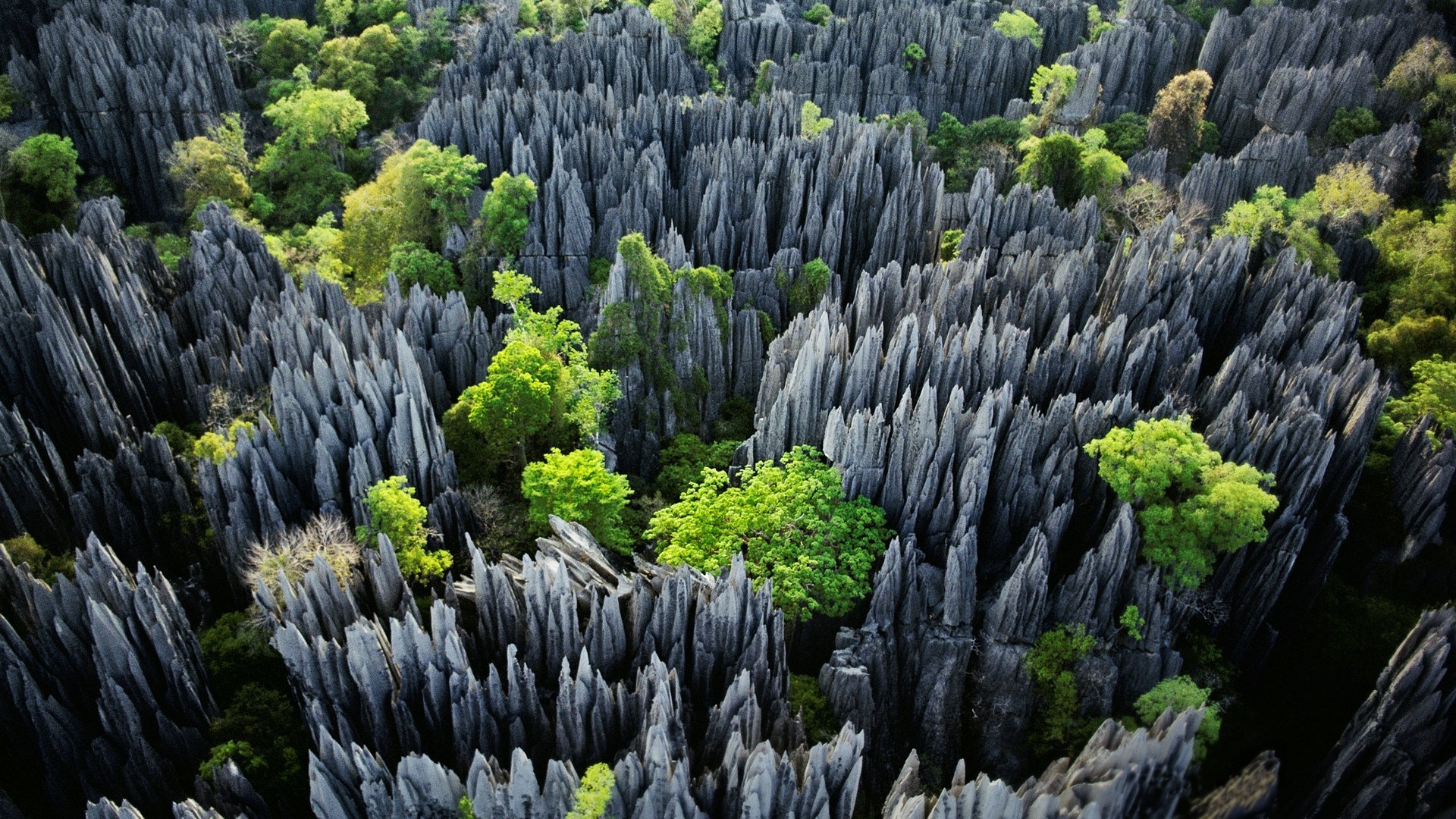
TSINGY de BEMARAHA World Heritage Site Near the western coast of Madagascar, it has a unique geography, preserved mangrove forests, and wild bird and lemur populations. The fascinating raised limestone plateau is decorated with a frail, chaotic razor-sharp collection of pinnacles, the “Tsingy”, also called the Labyrinth of Stone. The word “Tsingy” is derived from a local word meaning “the place where one cannot walk barefoot”. In the deciduous forest see 7 species of lemurs (including the all-white Deckens sifaka), 50 species of birds. the rare stump-tailed chameleon. Flora includes: aloes, orchids, numerous pachypodium and baobabs Access is restricted. Located approximately 180 km and a 12-hour drive north of Morondava. An armed transport is required.
Itinerary for Tsingy de Bemaraha / Avenue of the Baobabs
Tour Operators. It is difficult to find simple 3-day trips out of Morondava as most companies offer long 8-15-day tours with the Tsingy in the middle. Madagascar Tours (the one first in Google search offered a tour for $760).
a. Tsiky Tour. They were recommended by one of the companies I had emailed and offered a tour starting immediately for $560, a price much less than anyone else. [email protected], WA +261340289812.
The financial arrangement was very unusual. Instead of us each paying a reduced amount, Ariel simply paid half of my tour fee to me (it was my vehicle and trip I guess). What a great deal for me as I only ended up paying $230 for the entire three days including two in a nice hotel with breakfast included.
b. Herman. He was used by a group of Germans with a very cheap price who gave me his number and he replied. +261320200632
Day 1: Morondova – Bekopaka. Morning depart for Bekopaka.
We drove through the Avenue de Baobabs (30 minutes north), an astonishing collection of huge baobab trees. We walked the entire avenue, took many photos and were picked up the end. We drove another 7 km to the Baobab Amoureux. There was then a large “forest” of hundreds of smaller baobabs spread over a large area.
Ferry to Belo sur Tsiribihina. We took the great ferry over the Tsirbihina River. It was a flat-decked ferry carrying four vehicles and powered by two ancient 20-horsepower engines. A belt drove the propellers and the two drivers poured gallons of water into the reservoir on top to cool the engines. The ferry went upstream about 3 km to the takeout.
The 11.5 hour drive was on dirt roads, some smooth, other washboard and a lot washed out ruts. In every village, there were tons of little kids. They all held out their hands asking for bottles (for which they get money?). Some pointed to my red stud earring. Just before Bekopaka, we crossed the Tsibirinha River on another ferry.
We had dinner at 7 and went to bed early. Ariel had arrived in a delayed van at 5 am and had only slept for 1 hour (1 hour more than me) so we both very knackered.
ON Orchidee Hotel, Bekopaka. Ariel shared a big king size bed.
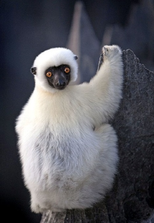
Day 2 (6) Mon June 12. Bekopaka. Tsingy de Bemaraha National Park. Tsingy is the Malagasy word for “walking on tiptoes”. The site is famously home to a jagged, pointed limestone formations, hence the reason to “walk on tiptoes”. Large number of endemic fauna and flora.
We had BF at 6 and were off early for the 50min drive on a bad water eroded road with some water and mud holes. A large portion is relatively impenetrable. We were met by our guide who gave us climbing harnesses with two locking carabiners. Walk through the forest first – we saw some “brown” lemurs. Then start on a constructed loop trail with ladders, limestone rocks “nailed” into the stone as steps, boardwalks and a nice cable bridge above an abyss. There were many cables bolted into the rocks to attach our carabiners, but I thought it all unnecessary and in fact cumbersome as we were always transferring carabiners to the next cable. There are two great viewpoints and never used the carabiners after the first view point. We had lunch of a bunch of bananas in the “cathedral” and area at the bottom of the tsingy in the shade. We also saw a rat, a gorgeous mongoose with a long brown/black striped tail and three lovely Deckens sifaka as they leapt between branches in the canopy of the trees. The entire tour took about four hours.
One of the things that had fascinated me about the tsingy when I first saw an article in National Geographic was the Deckens sifaka climbing on the needle sharp tsingy. Our guide in his five years of guiding had never seen the lemur on the tsingy. They must have baited them with food to get them there.
We were back at 13:30 for an afternoon off.
ON Orchidee Hotel, Bekopaka.
Day 3 (7) Tue June 13. Bekopaka – Morondava. Up at 5, we had BF at 6 and departed back at 06:30 to Belo sur Tsiribihin and the ferry to Tsimafana. Small Tsingy (about 1 – 1.5 hours). We went to the “real” Baobab Amoureux” another two big trees twisted around each other and maybe better than the one most commonly seen. There were hundreds of nice w00d carvings of baobabs for sale here. I should have bought one but didn’t. Sunset at the Avenue of the Baobabs. Everyone congregates on the east side of the avenue behind a pond full of lilies for sunset silhouettes. But most leave well before the best colour that happened at least 30 minutes after sundown. The best photos were back at the road with the side of the tree lit.
Our driver was able to get tickets with Cotisse to leave at 05:00 the next morning.
ON Havana Hotel Morondava. 60,000 MA Back in this nice hotel sharing a room with Ariel.
Day 8 Wed June 14
I had tried to book a flight with Air Madagascar (Tsardaria, their domestic airline) but the website didn’t work and I had been too lazy to drive out to the Air Madagascar office in Morondava. The incredibly bad road trip from Morondava back to Tana. 17 hours, 60,000 MA. Check-in at Cotisse at 4:30 am with a 5:00 departure. This trip is a real character builder almost guaranteed to start PTSD.
We arrived back in Tana at 9 pm, 1/2 hour faster than the first time.
ON Madagascar Underground.
Day 9 Thur June 15
I had a big decision to make – either continue in Madagascar and deal with all the transportation issues to see 1 or 2 WHS and regions or just give up. I gave up and booked my flights to Comoros and then China leaving on the 15th instead of the 16th.
Flight TNR-Moroni (HAH). Kenya Airlines TNR-NBO @16:25-19:45 KQ257 3’20”. 14’25” layover. June 16 NBO-HAH@10:30-13:00 KQ264 2’30” US$470.
========================================================
I didn’t see any of the rest of Madagascar (from here down).
TOAMASINA (East North). EAST North
NOSY BORAHA (ILE ST. MARIE) (pop 26,500 2013) Previously known as Île Sainte-Marie (and still popularly known by travellers as such), is an island off the east coast of Madagascar. The main town is Ambodifotatra. This island is 60 km long and less than 10 km wide.
.png)
Whales. The channel between Nosy Boraha and Madagascar has substantial groups of humpback whales that migrate from the Antarctic to this breeding ground favourable both for courtship and the growth of their young before their annual migration to colder water. Although scarce, southern right whales, as a part of the recolonization of their former ranges, are known to appear along the coast from time to time.
Pirates. The island became a popular base for pirates, starting with Adam Baldridge in 1691 and ending with John Pro in 1719, it was not far from the maritime routes between the East Indies with holds overflowing with wealth; bays and inlets protected from storms; and finally, it had abundant fruit and was situated in quiet waters. Legendary pirates including William Kidd, Robert Culliford, Olivier Levasseur, Henry Every, Abraham Samuel and Thomas Tew lived in the île aux Forbans, an island located in the bay of Sainte Marie’s main town, Ambodifotatra. Many of them would find a family line.
Diving. Free from sharks, the lagoon of the island is endowed with significant coral.
Rich fauna and flora. Sainte-Marie has several species of lemur as well as numerous orchid species, among which is the “Queen of Madagascar”.
Eglise catholique d’Ambodifotatra de Sainte Marie Tentative WHS. The Catholic Church of Ambodifotatra is the crowning of ten years of evangelization missions (1837 to 1847) of Father Pierre Dalmond in Madagascar, mainly in Sainte Marie, Nosy-Be, Tuléar as well as in the Comoros, in Mayotte.
It is the first Catholic church in Madagascar. Oh a hill overlooking the bay, it is 35m long, 10m wide and 12m high and built of freestone, granite rubble using laterite mixed with gravel and sand as a binder. Later, the stone walls were reinforced and kept fixed by a heavy iron frame. With six arched and glazed windows on either side, the altar is made of cast iron plates cast in the arsenals of the French navy and features rosette motifs separating bas-reliefs of saints in medallion frames surmounted by crosses. At the back, a staircase of 19 steps leads to the balustraded gallery above the main door. The church has retained its original use and function, a place of worship for Catholics.
Without the support of the Kingdom of Madagascar, especially under the reign of Queen Ranavalona III (1883-1896), this Catholic evangelization mission had to be confined to the French islands, Sainte Marie and Nosy-Be. Father Dalmond also taught the natives to write and read.
Sainte Marie Airport (SMS)
Other destinations:
TOAMASINA (pop 300,813 2014). The capital of the Atsinanana region, it is the chief seaport of the country, situated 215 km (134 mi) northeast of Antananarivo. A coral reef which forms a spacious harbour, is entered by two openings. The city center is built on a sandy peninsula.
The town is the railhead for the line to the capital. Pousse-pousse (bicycle rickshaws), tuk-tuk (motorized rickshaws), and taxis are available throughout Toamasina to get around the city. Ambalamanasy Airport has limited domestic and international services. The city is the country’s main seaport for international shipping.
Toamasina Airport (TMM)
++++++++++++++++++++++++++++++++++++++++++++++++++++++++++++++
CENTER – Region Antananarivo (Antsirabe)
ANTANIFOTSY
Villages and Small Towns: Tsiroanomandidy
Ancien site industriel de Mantasoa. Tentative WHS. An artisanal industrial city built by Jean Laborde (1800 -1878), a French in the service of Queen Ranavalona I (1828-1861). It was the first in Madagascar to produce iron, cast iron, powder various articles, glass, soap and terracotta pots.
The site is made up of several stone, brick and wood constructions: Jean Laborde’s residence, workshops and stone furnaces (blast furnace, cementing furnace) used in the manufacture of guns and cannons, powder, pottery, paper, and furniture manufacturing.
Tomb of Jean Laborde. Hindu style with 10 rounded pillars supporting 72 balusters, facing 12 rows of cut stones for each side. This tomb is surrounded by several tombs belonging to members of his family. The last element is the swimming pool of Queen Ranavalona I (1828 – 1861), a landscaped basin using dry stones and lime mortar.
The property marked the 19th century of the period of European expansion of conquest, trade and transfer of industrial technology (Industrial Revolution) on the route to India. The industrial city functioned with chores, and compulsory work of able-bodied men from the surrounding villages by order of the Queen. These slavery-like chores marked the entire royal period in Imerina for the construction of large buildings including the five-storey Queen’s Palace built entirely in wood by Jean Laborde (1839).
History, Culture, National and City Museums: Ilafy: Ethnographic Museum
Rivers: Mahajilo River
Zoos: Ivato: Croc Farm
Waterfalls: Les Chutes de la Lily. Two large waterfalls, the highest twenty meters.
 ===========================================================================
Kirindy Mitea NP is 70 km south of Morondava on the coast of the Mozambique Channel, The 72,200 hectares (178,000 acres) park contains many endemic animals and plants and claims to have the greatest density of primates in the world. It also includes a marine area with seven small islands. It is surrounded by the Maharivo River and Lampaolo River. During the warm, dry season from March to November, much of the wildlife is hibernating, the vegetation is brown and the trees are leafless. Animals and plants come to life in the rainy season when the temperature can reach 40 °C (104 °F).
There is a wide range of ecosystems due to the reserve being in an area where southern and western biotypes meet. Within the park are the largest remaining area of dry deciduous forest, tropical dry forest, spiny forest, beaches and sand dunes, mangroves and coral reefs. One hundred and eighty-five species of plants have been recorded, among them three species of baobab, as well as seven species of mangrove trees.
In this park are found eleven species of mammals of which ten are endemic. Among them are Madame Berthe’s mouse lemur, the smallest primate in the world, which is only known from this park. Also the fossa, Madagascar’s largest living predator, and the lemur’s only predator (apart from people). Other mammals endemic to the Menabe region include the giant jumping rat and the narrow-striped mongoose. There are also forty-seven species of birds (thirty-three endemic) and twenty-three species of reptiles.
Other lemurs include the red-fronted brown lemur, Pale fork-marked lemur, Grey mouse lemur, Coquerel’s dwarf lemur, Fat-tailed dwarf lemur, Red-tailed sportive lemur, and Verreaux’s sifaka.
TOLIARA (pop 168,758 2018). The capital of the Atsimo-Andrefana region is located 936 km southwest of Antananarivo. As a port town, it acts as a major import/export hub for commodities such as sisal, soap, hemp, cotton, rice and peanuts.
The Vezo, nomadic fishermen, are the indigenous ethnic group. Today they are being dominated by migrants from the South (Mahafale, Masikoro, Antandroy) which make up more than half of the urban population.
Toliara’s cathedral is the archiepiscopal seat of the Roman Catholic Archdiocese of Toliara, The Ifaty beach near Tulear is famous for its water and sands.
The Bay of Toliara houses one of Madagascar’s oil exploration sites. The sea floor is rich in minerals gemstones and ground salt. More recently, Canadian companies have begun operation of the ilmenite.
Tourism is a promising sector, thanks to the climate and natural assets of the hinterland (Ifaty Anakao, St Augustine). Calm shallow seas and shallow support scuba diving.
Toliara is located on a broad coastal plain, surrounded by dunes and mangroves, near the Tropic of Capricorn in the Mozambique Channel. The colonial legacy is still visible in the architecture and the urban landscape.
Arboretum d’Antsokay. Established in 1980 at the initiative of the Swiss amateur botanist Petignat Hermann (1923-2000). This arboretum covers an area of 52 hectares, with more than 920 plant species, lemurs, radiated tortoises, snakes and chameleons.
============================================================
MAHAJANGA and ANTSIRANANA (Nosy Be)
NOSY BE. (pop 109,465 2018) Island off the NW coast, it is Madagascar’s largest and busiest tourist resort. Area of 320.02 km2.
The French colonized the island in 1840. In 1849, slavery was abolished by the French, though the slaves were owned by Malagasies. They founded a plantation colony in Nosy Be, mainly producing sugar and cash crops.
Lynching of tourists, 2013. Rumours quickly turn into accusations in Madagascar, and lynchings are common, even for allegations related to traffic accidents or theft. In 2013, the body of an 8-year-old boy was discovered at the beach. French tourists: Roberto Gianfalla and Sébastien Judalet were found and dragged from their hotel to the beach of Ambatoloaka, where the large mob repeatedly hit them with sticks and stones. After three hours of torture and humiliation, the naked and bleeding tourists were put into car tires and thrown alive into a bonfire on the beach. Uncle Zaidou and a mob of several hundred quickly lynched him by burning him alive on a public street.
Most lynchings concern locals, but expatriates are frequently subject to kidnapping and extortion.
Nosy Be is 8kms from the coast in the Mozambique Channel; near several smaller islands. The island’s main town is Andoany. The volcanic island has Mont Lokobe at 450 metres (1,480 feet). There are eleven volcanic crater lakes on the island.
Nosy Be has a tropical monsoon climate. The island’s main activities are now the plantation of ylang-ylang (for the production of essential oils) and tourism. This is the only place in Madagascar where all-inclusive large resorts can be found.
Fascene Airport is serviced by commercial flights with Air Madagascar, Air Austral, Ewa, and Ethiopian Airlines, and has direct flights from Europe on Neos. Its main city and harbour, Hell-Ville, can be reached by boat from Ankify.
Reefs pristine.
Nosy Be Airport (NOS)
Urban Legends: Mahatsingo Sacred Tree
Zoos: Lemuria Land
M@P: Nosy Be and Nosy Komba


Other Destinations
Tsingy de Ankarana is a small version of the Tsingy de Bemaraha. This park in the north is on the national road to Antisirana and is thus easily accessible. The park also is home to three types of lemurs, chameleons,…
Antsiranana. (pop 115,000 2013) in the far north. Antsiranana Bay is one of the largest deep-water harbours in the Indian Ocean, but the remote location, and, until recently, a bad road to the south, rendered it unimportant for freight traffic.
In the 1880s, the bay was coveted by France as a coaling station for steamships and in 1885 granted to France, as well as the islands of Nosy-Be and Ste. Marie de Madagascar. France operated a military base following Malagasy independence in 1960 until 1975.
Antsiranana has a tropical savannah climate with long, hot summers and a wet season from December to March.
Among the places of worship, they are predominantly Christian and some mosques.
Antsiranana and northern cape. XL
Antsiranana Airport (DIE)
Mahajanga. Seaport, favourite tourist destination – beaches, a coconut-lined boardwalk (“Le Bord”, and eight months of hot, virtually rain-free weather.
There is an international airport with regional flights to the Comoros and Mayotte.
The city has a sizable Muslim population. In 1977, ethnic unrest forced the evacuation of the Comorian minority living there.
The African baobab tree near the coast is the largest specimen in Madagascar, having a circumference of 21 metres (69 ft), and is the symbol of the city. Its age is unknown, but it is usually said to be 700–800 years old.
Since the tenth century, ports in the north of Madagascar, home to an Islamized population, had attracted Muslim traders from India, merchants and migrants from East Africa, the Middle East, and even the Far East. In 1911, 4,480 Indians lived in the country (21% of the total foreign population and second to the French). Following the nationalization of private businesses in the 1970s, many left; those who remained built their businesses and by 2000 controlled 50-60% of the country’s economy, making them the target of demonstrators during periods of unrest.
Mahajanga Airport (MJN)
Mary Immaculate Heart Church
Akiba Museum, Majunga.
Tanjona Masoala Lighthouse. Amboditaitry.
Beaches: Anjajavy Beach, Mitsio Islands Beaches, Tsarabanjina island
M@P: Andranovondronina municipality (extreme north)
RAINFORESTS of the ATSINANANA. World Heritage Site (2007). Consists of six national parks in eastern Madagascar. These relict forests are important for unique biodiversity, which reflects the island’s geological history. Having separated more than 60 million years ago, Madagascar’s plant and animal life evolved in isolation especially lemurs and other primates.
These two National Parks are in the far northeast.
1. Marojejy National Park. In northeastern Madagascar, 214 sq mi centred on the Marojejy Massif, a mountain chain to 2,132 m (6,995 ft). Unique in the world with dense, jungly rainforests, sheer high cliffs, and plants and animals found nowhere else on earth. Have implemented community-based initiatives to mitigate poaching and selective logging, by encouraging local communities to engage in reforestation and silviculture initiatives to promote a sustainable alternative to mining, slash-and-burn agriculture, and wood collection.
The wide range of elevations and rugged topography: warm, dense rainforest lower elevations, shorter forests at higher elevations, followed by cloud forest, and topped with scrub. The eastern side receives more rain, 118 birds, 148 reptiles and amphibians, and 11 species of lemur. The silky sifaka is listed among “The World’s 25 Most Endangered Primates”. The helmet vanga is considered the iconic bird species of the park.
One path leads from the entrance of the park to the summit with three camps: Camp Mantella at 450 m (1,480 ft), Camp Marojejia at 775 m (2,543 ft) and Camp Simpona at 1,250 m (4,100 ft) in the middle of the montane rainforest, the base camp for the 2km, 4-5 hour trek to the summit.
2. Masoala National Park. XL: Masoala peninsula. In NE, has 2,300kms2 of tropical rainforest, coastal forest, flooded forest, marsh, and mangrove and 100km2 in three marine parks: Tampolo in the West, Ambodilaitry in the South, and Ifaho in the East.
From July to early September, humpback whales visit Antongil Bay during their long migration. The warm protected waters of the bay provide an ideal breeding and calving ground, with coral reefs and a dazzling array of marine life.
There are ten lemur species, including the flamboyant red ruffed lemur, which is native to the peninsula. The island reserve of Nosy Mangabe has the elusive nocturnal aye-aye.
Others include the Madagascar day gecko, leaf-tailed gecko, chameleons of all sizes, spectacular birds such as the helmet vanga, and rare species such as the red owl and tomato frog, the spectacular day-flying sunset moth.
Transportation: The park can be accessed from the towns of Maroantsetra (motor boat) or Antalaha (road to Cap Est using daily bush taxis or by mountain bike as far as the village of Masoala). Antalaha and Maroantsetra both offer a wide array of accommodations, guides (all visits to the park must be accompanied by an official park-approved guide with guide offices in Maroantsetra and Antalaha. This is an exceptionally wet area driest in September to December. As the park is accessible only by a three-hour boat journey, the cyclone season (January to March) is best avoided. In 2009-10, it was invaded by thousands of illegal loggers looking for rosewood.
There are several lodges and six park-maintained campsites (Nosy Mangabe, Cap Est, Ambatolaidama, and each of the three marine parks). The main trails for visitors are at Nosy Mangabe, Tampolo/Ambodiforaha, Cap Est, and a several-day hike is possible across the peninsula. Many villages have inexpensive bungalows or basic guest rooms.
Tentative WHS
Nosy Lonjo d’Antsiranana. Located in the bay of Diego-Suarez (Antsiranana), it is a 4.5-hectare conical volcanic islet 122 meters high. Has typical baobabs and mangroves and fruit bats. Burial place for the late Sakalava sovereigns, and therefore sacred.
NOSYnakà (Sahamalaza, Nosy Hara, Nosy Tanikely, Lokobe, Ambodivahibe, Ankarea, Ankivonjy). In the northern part of Madagascar, this includes the continental shelf, volcanic, karst (eroded reef structures) and sedimentary rock, deep and narrow bays with coral reefs, mangroves and seagrass beds and islands.
The south-equatorial Agulhas Current off South Africa and Northern Mozambique has 7 marine protected areas. 1. Nosy Hara Marine National Park, 2. Sahamalaza National Park Radama Islands, 3. Lokobe National Park, 4. Nosy Tanikely National Park, 5. Marine Protected Area of Ambodivahibe, 6. Marine Protected Area Ankivonjy, and Protected Marine Area Ankarea.
Réserve Spéciale d’Anjanaharibe-Sud (14/03/2008). The tropical humid forests are scattered over the Central High Plateau and the north. The climate is tropical and humid, characterized by abundant precipitation. From north to south, there are several types of ecosystems representative of the humid forests of Madagascar: transition forests, altitude meadows, natural savannah and coral reefs. These ecosystems contain a unique biodiversity of which most animal and plant species are endemic.
Includes he national parks of Marojejy, Masoala, Zahamena, Ranomafana, Andringitra and Andohahela.
An extension of the property of Anjanaharibe-Sud Special Reserve is a forest corridor named Betaolana to Marojejy NP, which is almost an isolated islet with a diversity for amphibians, reptiles, ferns and palms (211 species of ferns including the fossil plant Takhtajania perrieri Baranova rediscovered n 1994, after 85 years. It is a reliquary representative of a Gondwanian distribution.
World of Nature
Ambatovaky Reserve..A remote dense deciduous dry forest in the north-east only accessible by canoe along the Marimbona River that forms the southern border. The reserve headquarters are in Soanierana Ivongo. The last place for the critically endangered lemur, Perrier’s sifaka plus five other species of lemurs, four endangered. 55 endemic birds.
Amber Mountain NP. An isolated basaltic volcanic massif, known for its endemic flora and fauna, waterfalls and crater lakes. Has 75 birds, 25 mammals, and 59 reptiles. The park is a water catchment area for Antsiranana with 141.1 in or rain compared with 39 in around the town. Most are montane rainforests with trees up to 40 metres (130 ft) tall covered in lianas, orchids and ferns. Surrounded by dry, sparse forests and semi-desert. Amber is one of the most accessible parks in northern Madagascar. Bush taxis travel 45 minutes to Joffreville daily from Antsiranana.
Analamerana Reserve. 347 km2 wildlife reserve in the north to protect the critically endangered Perrier’s sifaka. Altitude is between sea level to 648m as a karstic eroding limestone plateau, between the Indian Ocean and the Ankarana-Analamerana massif. Due to the lack of infrastructure, the reserve is difficult to access, with the best time to visit, from May to September. The nearest town is Anivorano Nord. The roads around the reserve are poor and Diego Suarez provides the easiest access point.
Ankarana Reserve. 2,000mm (79 in), karst with caves and underground rivers, and a rugged relief with dense vegetation have helped protect the region from human intrusion.
On the west, it ends abruptly in the 280m high “Wall of Ankarana”, a sheer cliff that extends 25 kilometres (16 mi) north to south. To the south, the limestone mass breaks up into separate spires known as tower karst. In the center are deep gorges, and sometimes redeposited it in ribbons of flowstone. In places where the calcific upper layers have been completely eroded, the harder base rock has been etched into channels and ridges known as tsingy.
The largest sinkhole, the Mangily sinkhole, measures 700m across and 140m deep. A total of about 100 km of cave passages have been mapped.

Ankarafantsika NP. Tropical patches of thick dry tropical forest, savannah, scrub and sandy eroded rock areas. The closest city is Majunga 115kms north of the park. The Sakalava people live and farm here.
Tsingy de Namoroka NP. In the northwest 50 km south of Soalala. The park is known for its tsingy walls, caves, canyons, and natural swimming pools.
Baie de Baly NP. 150kms to Mahajanga. The Tsingy de Namoroka National Park borders this park. Vegetation consists of dry forests, scrub-shrub or bamboo shrubs, mangroves, lakes and swamps mixed with savanna. The only known natural habitat of the critically endangered ploughshare tortoise. Other rare animals are the Madagascan side neck turtle and the Madagascar fish eagle.
Bemarivo Reserve. In the NW coastal plateau about 12 km from the town of Besalampy, and 5 km from the Mozambique Channel coast, The dense, dry deciduous forest has 75 birds, 22 reptiles and 15 mammals (including 6 lemurs), 24 reptiles and 194 plants.
Bora Reserve. A wildlife reserve in the Sofia Region between the villages of Antsohihy and Bealalana in a transition zone between eastern humid forests and western dry forests. Has six lemur species, 20 birds and 150 endemic plants.
35 km from Antsohihy. In the north, the park is accessible by the tarmacked road, RN31.
Tsaratanana Nature Reserve. Located at a high altitude and is the source of many rivers. two waterfalls and thermal baths. Closed to the public.. Maromokotro peak is the highest mountain of Madagascar at 2,876 m (9,436 ft). The forests in the park are threatened with illegal logging due to obtaining areas for illegal cultivation of marijuana, vanilla and rice. It is located 57 km (35 mi) north of Bealanana.
==============================================================
EAST South FIANARANTSOA
FIANARANTSOA
History. It was built in the early 19th century by the Merina as the administrative capital for the newly conquered Betsileo kingdoms.
Fianarantsoa means “Good education” in Malagasy. It is a cultural and intellectual center for the whole island. It is home to some of the oldest Protestant and Lutheran cathedrals on the island, the oldest theological seminary (also Lutheran), as well as the Roman Catholic Archdiocese of Fianarantsoa (seated in the Cathedral of the Holy Name of Jesus). The city of “good education” also boasts a university named after it and built in 1972. Fianarantsoa is considered to be the capital of wine in Madagascar, because of the presence of many wine industries in the city.
Fianarantsoa has been known for its political activism and was one of the “hot spots” during the political crisis in 2002. Students of the University of Fianarantsoa have a reputation for sympathizing with radical leftist groups.
Fianarantsoa was placed by the World Monuments Fund on its 2008 Watch List of the 100 Most Endangered Sites because many of the buildings in the old town are in dire need of repair.
Fianarantsoa-Côte-Est railway
Ambozontany Cathedral
Transport Tana to Fianarantsoa.
Bus from Tana to Fort Dauphin every day at 11pm via Fianarantsoa at 11pm every night.
Le Cotisse – 7am. 4 of them all leave the station at the same time.
RN7 going south 400k in 12 hours. Last 3 hours there are some big trees. Tsara Guest House in Fianarantosoa nice.
Fianarantsoa to Tuléar. (wanted to go to Toalognaro). Taxi brousse costs 30 000 ariary 12 hours.
Tana-Antsirabe (day 1) to Ambositra- Ranomafana (day 2)
Day 3 Ranomafana NP
Day 4 Ranomafana -Fianarantsoa-Ambalavao: visit of the wine factory and paper Antemoro fabrikand continuouing to Ranohira with stop at the reserve of Anja to see the ringtailed lemurs
Day 5-6 Andringitra NP and/or Tsaranoro reserve by Camp Catta with the Chameleon rock
Day 7-8: Isalo NP
The national parks are an off-road drive away from RN7, making for challenging access without a car
*Ranomafana National Park. In the southeast with 161 square miles of tropical rainforest, it is home to several rare species of flora and fauna including the golden bamboo lemur, the greater bamboo lemur, black and white ruffed lemur and Milne-Edwards sifaka, and over 130 species of frogs. Bird species include ground rollers, blue vangas, short-legged ground rollers and brown mesites.
The park is 65 km NE of Fianarantsoa and 139 km W of Mananjary. National Roads nos. 45 and 25 cross the park. The park office is at the entrance in the village of Ambodiamontana, at 6.5km from Ranomafana.
The park is an important example of cloud forest, with very high levels of biodiversity.
A local guide is required for visitors entering the park arranged at the park office. See lemur, gecko, chameleons, and bird species in the Talatakely forest with well-defined paths and stairs. Kayaking or canoeing can be arranged and a hot springs pool is located in Ranomafana.
There are a lodge and an ecolodge of a private tourist operator at the entrance of the national park. There are also several hotels in Ranomafana village available for lodging. Additionally, it is possible to camp at the campsite near the main road through the park or to find lodging at Centre ValBio, where most of the scientific research is based.
Cathedral of the Immaculate Heart of Mary, Ambositra:
World of Nature
*Andringitra NP. Hike to view the mountain. 3 days to climb
*Isalo NP. One day hike. Ring-tailed lemurs
Kalambatritra Reserve
Manombo Reserve
Midongy du Sud NP
Ranomafana NP
Ranomafana Arboretum, Ranomafana
Riandahy and Rianbavy Falls. Situated on the Zomandao River in the Andringitra Massif near the Andringitra National Park. At a distance of less than one km from these falls, there are also the Rianbavy Falls
Sakaleona Falls. The highest waterfalls of Madagascar, with a height of 200 metres (660 ft). They are situated on the Sakaleona River in the Vatovavy-Fitovinany region, some 18 kilometres (11 mi) from the village of Ampasinambo and about 107 kilometres (66 mi) from Nosy Varika.
World Heritage Site
RAINFORESTS of the ATSINANANA. World Heritage Site (2007). Consists of 13 specific areas in six national parks in the eastern part of Madagascar. These relict forests are critically important for maintaining ongoing ecological processes necessary for the survival of Madagascar’s unique biodiversity, which reflects the island’s geological history. Having completed its separation from all other land masses more than 60 million years ago, Madagascar’s plant and animal life evolved in isolation especially lemurs and other primates.
1. Zahamena National Park. At 423kms2, the park has 112 birds, 46 reptiles, 62 amphibians and 48 mammals, including 13 species of lemurs. The ethnic groups inhabiting the area are mostly Betsimisaraka and Sihanak. The most prominent faunal species in the park are: Indri indri (babakoto), a black lemur with white patches; the Madagascar red owl, the katsatsaka, a small gecko; the Madagascar serpent eagle, a threatened species; and the red-tailed newtonia, a very common bird species in the park. The park is 40kms NE of Ambatondrazaka, 4 kilometres (2.5 mi) from Manakambahiny-East, 70 kilometres (43 mi) to the northwest of Tamatave and about 25 kilometres (16 mi) east of Lake Alaotra. It is considered to be difficult to reach, so doesn’t attract many tourists. It is located in rugged, undulating topography with an elevation range of 254–1,560 metres. Rain 180–200 cm; the average temperature is 15-28C.
The threat faced by the park is generally from the poor farmers who reside on the boundary of the park with “slash-and-burn cultivation and hunting, fires, poaching, cutting of precious trees such as rosewood and ebony, and gem mining.
2. *Andringitra National Park. 47kms S of Ambalavao, it has 31,160 hectares covering much of the granite massif of the Andringitra mountains which rise above plains. The altitude varies from 700m (2,300 ft) to the second-highest mountain in the country, Imarivolanitra (Pic Boby) at 2,658 metres (8,720 ft). The mean annual rainfall is 1,500–2,500 millimetres (59–98 in) and snowfall occurs in some years. Madagascar’s lowest temperature, −8 °C (18 °F) has been recorded here.
Three groups live within the park: Bara people in the SW graze cattle on the savannah and in the valleys and on the ridges; Bara Haronga in the E grow rice, and the Betsileo people have developed an irrigation system on the mountain flanks of the north for rice cultivation.
The park is one of the most biologically diverse places in Madagascar, with many endemic species. The eastern flank of the massif is covered with humid forest, and humid grassland and scrub in the higher areas. On the western flank there is relatively dry forest. There are over 1,000 plants, 100 birds, and 55 frogs, 50 mammals, including thirteen species of lemur. Andringitra’s ring-tailed lemur population has notably thicker fur than the rest of the island’s population. This is likely an adaptation to the colder climate at high altitudes.
3. Andohahela National Park. In the SE, it has extremes of habitats in 760 km2 of the Anosy mountain range, the southernmost spur of the Malagasy Highlands and contains the last humid rainforests in the southern part of Madagascar.
It is 40 km NW of Tôlanaro and is divided into three zones: Malio – ranges from 100m to the summit of Pic d’ Andohahela at 1,956 metres (6,417 ft), and has dense rainforest with more than two hundred species of tree ferns, orchids, wild vanilla, lemurs and many birds. The second, Ihazofotsy-Mangatsiaka, contains dry spiny forest with rare birds and reptiles in altitudes ranging from 100 to 1,005m at the summit of Pic de Vohidagoro. The third zone, Tsimelahy, is mainly at an altitude of 125 metres (410 ft), and contains the unique Ranopiso transitional forest. Rainfall of 59–79 in per year that supports one of the few rainforests south of the Tropic of Capricorn. The western edge has 24–28 in per year resulting in a dry spiny forest characteristic of southern Madagascar.
Several circuits within each of the habitat types of the park can be accessed by road from the town of Tolagnaro.
The park is the richest place in Madagascar for lemurs with 15 species, including two of Madagascar’s most emblematic species, the ring-tailed lemur and Verreaux’s sifaka. Some rare species of geckos, turtles and snakes are among the 67 species of reptiles found in the park, 130 species of birds and fifty species of amphibians.
