
NILE VALLEY – MIDDLE EGYPT (Luxor, Aswan, Sohag, Asyut, Qena)
Observations
1. People. Generally very nice and helpful. The touts can get to you – mainly taxi drivers, horse and carriage drivers and feluccas in Aswan. My way of dealing with them is generally to ignore them as that makes for the shortest interactions. Even saying “No thank you” tends to not stop them. Then they say “Tomorrow?”.
The universal greeting is “Welcome” and then “Country?”. To Canada, they universally say “Canada Dry”. It gets to you as we never drink or see Canada Dry in Canada.
2. Prices. Egypt is very cheap. Hotels are 200-400 EP ($8-16). Dinner is rarely more than 100 EP. Use Uber in Cairo and InDrive in Aswan for taxis. A SIM card /10 GB data is $10 and top up $4 (Vodafone).
Tours however are expensive. I paid $250 for the long one-day drive to Kharga from Luxor (no bus) and $250 for the car/driver to Valley of the Kings, Luxor to Kom Ombo and then a felucca for 2 days/1 night. And then there is always a tip expected. My driver was exceptionally good and it would have been hard getting public transport to all the places I visited.
North of Luxor – sites listed from south to north from Luxor. I should have come south from Fayoum and seen Minya, these towns and 2 Tentative WHS instead of going to Hurghada via the Red Sea. To see them from Luxor is a 2-day trip that is expensive.
Qena – village on the other side of the river from Dendera
Dendera Temple complex. Vestiges of the Past. Located about 2.5 km southeast of Dendera (north of Luxor), inhabited in prehistory and is a useful oasis on the banks of the Nile. It is one of the best-preserved temple complexes in Egypt. Pepi I (ca. 2250 BC) built the first and the earliest extant building the mammisi raised by Nectanebo II – the last of the native pharaohs (360–343 BC).
Nearby is the Dendera necropolis, a series of mastaba tombs. The necropolis dates from the Early Dynastic Period of the Old Kingdom to the First Intermediate Period of Egypt.
Temple of Hator Built by Ramses III (01/11/1994). The Temple of Hator is part of the Dendera temple complex. It was built by Ptolemy XII (so not by Ramses III despite the title). The existing structure began construction in the late Ptolemaic period at the time of Ptolemy Auletes in July 54 BCE. and the hypostyle hall was built in the Roman period under Tiberius. The temple is among the best preserved in Egypt with fine decorations and original colours. It has 12 underground crypts. It continued to be used til the era of the Roman emperor Trajan. This site is also part of a later TWHS: Pharaonic temples in Upper Egypt from the Ptolemaic and Roman periods.
The sculptured Dendera zodiac (or Denderah zodiac) is a widely known relief found in a late Greco-Roman temple, containing images of Taurus (the bull) and the Libra (the balance).
The Roman mammisi is a subsidiary building dating to the reigns of Trajan and Marcus Aurelius. Numerous reliefs of Trajan making offerings to Egyptian deities can be seen.
Abydos, the city of pilgrimage of the Pharaohs. Tentative WHS (28/07/2003). One of the oldest cities of ancient Egypt, it is 11 kilometres west of the Nile. It was a sacred city and the site of many ancient temples, including Umm el-Qa’ab, a royal necropolis where early pharaohs were entombed. These tombs began to be seen as extremely significant burials and in later times it became desirable to be buried in the area, leading to the growth of the town’s importance as a cult site.
Today, Abydos is notable for the memorial temple of Seti I, which contains an inscription from the Nineteenth Dynasty known to the modern world as the Abydos King List. It is a chronological list showing cartouches of most dynastic pharaohs of Egypt from Menes until Seti I’s father, Ramesses I. It is also notable for the Abydos graffiti, ancient Phoenician and Aramaic graffiti found on the walls of the Temple of Seti I.
The Great Temple and most of the ancient town are buried under the modern buildings to the north of the Seti temple. Many of the original structures and the artifacts within them are considered irretrievable and lost; many may have been destroyed by the new construction.
Sohag – small town
Asuit – small town with Alexa Pasha Palace
Day 6 Dec 11. I took the bus from Hurghada to Luxor (320 EP, 3.5 hours), and crossed the Nile to the West Bank to my hotel. I rested for the rest of the day
Day 7 Dec 12. I had arranged a 5-day package to see The Valley of the Kings, Kharga Oasis and then a road trip down the Nile to Kom Umbo where I had booked a felucca for a 2-day/1 night Nile cruise.
ON Pyramids Luxor Hotel. On the West Bank, this is a lovely hotel hidden amongst several buildings. Private rooms with ensuites for 300 EP/night. Great breakfast.
LUXOR (pop 127,994 (2020), is among the oldest inhabited cities in the world. The modern city includes the site of the Ancient Egyptian city of Waset, also known as Nut and to the Greeks as Thebes or Diospolis. Luxor has frequently been characterized as the “world’s greatest open-air museum”, as the ruins of the temple complexes at Karnak and Luxor stand within the modern city. Immediately opposite, across the River Nile, lie the monuments, temples and tombs of the west bank Necropolis, which includes the Valley of the Kings and Valley of the Queens.
Luxor was the ancient city of Thebes, the great capital of Upper Egypt during the New Kingdom, and the glorious city of Amun, later to become the god Amun-Ra.
The economy is heavily dependent upon tourism with agriculture, particularly sugarcane. Industries include pottery. The local economy was hit by the Luxor massacre in 1997, where 64 people (including 59 visiting tourists) were killed, at the time the worst terrorist attack in Egypt (before the Sharm el-Sheikh terrorist attacks). The massacre reduced tourist numbers for several years. Following the 2011 Arab Spring, tourism to Egypt dropped significantly, again affecting local tourist markets.
A controversial tourism development plan aims to transform Luxor into the biggest vast open-air museum: new roads, five-star hotels, glitzy shops, and an IMAX theatre. The main attraction is to restore the 2.7 kilometres long Avenue of Sphinxes that once linked Luxor and Karnak temples. The ancient processional road was built by the pharaoh Amenhotep III and has over a thousand sphinx statues
2013 hot air balloon crash. Nineteen Asian and European tourists died when a hot air balloon crashed following a mid-air gas explosion.
Luxor Airport (LXR)
ANCIENT THEBES with its NECROPOLIS. World Heritage Site.
An ancient Egyptian city on the Nile about 800kms south of the Mediterranean. Its ruins lie within the modern Egyptian city of Luxor. Thebes was the capital of Egypt for long periods during the Middle Kingdom (c.2055–1650 BC) onwards. The vast majority of the ancient Egyptian monuments that can still be visited there today were built during the New Kingdom (c.1550–1069 BC), Egypt’s age of empire.
It was close to Nubia and the Eastern Desert, with its valuable mineral resources and trade routes. It was a cult centre and the most venerated city during many periods of ancient Egyptian history. The site of Thebes includes areas on both the eastern bank of the Nile, where the temples of Karnak and Luxor stand and where the city proper was situated; and the western bank, where a necropolis of large private and royal cemeteries and funerary complexes can be found.
Populations: 2000 BC – 40,000 (60,000 in Memphis, the largest city in the world at the time. By 1800 BC, Memphis was down to 30,000, making Thebes the largest.
1500 BC – 75,000 and the largest city in the world, a position held until 900 BC, when it was surpassed by Nimrud.
WESTERN THEBES
VALLEY of the KINGS. For 500 years from the 16th to 11th century BC, rock-cut tombs were excavated for the pharaohs and powerful nobles of the New Kingdom (the Eighteenth to the Twentieth Dynasties of Ancient Egypt).
The valley stands on the west bank of the Nile, opposite Thebes (modern Luxor), within the heart of the Theban Necropolis. The wadi consists of two valleys: the East Valley (where the majority of the royal tombs are situated) and the West Valley (Valley of the Monkeys).
With the 2005 discovery of a new chamber and the 2008 discovery of two further tomb entrances, the valley is known to contain 63 tombs and chambers (ranging in size from a simple pit, to a complex tomb with over 120 chambers). It was the principal burial place of the major royal figures of the Egyptian New Kingdom, as well as a number of privileged nobles. The royal tombs are decorated with scenes from Egyptian mythology and give clues as to the beliefs and funerary practices of the period. Almost all of the tombs seem to have been opened and robbed in antiquity, but they still give an idea of the opulence and power of the pharaohs.
In modern times the tomb of Tutankhamun (with its rumours of the curse of the pharaohs) is one of the most famous archaeological sites in the world. In 1979, it became a World Heritage Site, along with the rest of the Theban Necropolis.
How to see the Valley of the Kings.
Watch what you pay for as the touts are everywhere
Guide books. I foolishly purchased a guidebook to the Valley of the Kings and Valley of the Queens for 300 EP. Both are unnecessary.
Guides. They quoted prices from $5-20 but are probably unnecessary. Do your own research. There are storyboards outside many of the tombs. They are not allowed to enter the tombs so use the above picture books to explain outside the tombs.
All the tombs are virtually identical – long descending corridors and tomb rooms with a stone sarcophagus, all covered in hieroglyphics, most well painted. The ceilings were more elaborate.
Tickets
General Admission. Nine tombs can be visited but this ticket pays for three of them – your choice. Your ticket is punched for each so don’t just enter any tomb. A tout at the entry suggested the three best and then wanted money, so I foolishly gave him 20 EP. Most visitors were going to the same ones.
Tombs that require an extra admission. There are five on this list and I bought tickets for two of them Tutankamen 300 EP and Rameses V & VI 100 EP. Seti was 1000 EP as it had virtually intact paintings still vivid.
Cart. Large golf carts take from the entrance to the start of the valley, about 500m. 10 EP
Ramses #2.
Tutankhamen* #62. One of the smallest and simplest. Has his mummy. Painted with scenes and not hieroglyphics.
Ramses V & VI* #9
Tansat #14
Ramses II & III
After Valley of the Kings, turn west on a road and pass the following ruins.
DEIR EL BAHARI. The first monument built at the site was the mortuary temple of Mentuhotep II of the Eleventh Dynasty. It was constructed during the 21st century BC. During the Eighteenth Dynasty, Amenhotep I and Hatshepsut also built extensively at the site.
Mortuary Temple of Hatshepsut. This is the focal point of the Deir el-Bahari complex Djeser-Djeseru sits atop a series of colonnaded terraces, reached by long ramps that once were graced with gardens. It is built into a cliff face that rises sharply above it, and is largely considered to be one of the “incomparable monuments of ancient Egypt”.
The pillared galleries at either side of the central ramp of the Djeser Djeseru correspond to the pillar positions on two successive levels of the Temple of Mentuhotep. Most of the statue ornaments are missing – the statues of Osiris in front of the pillars of the upper colonnade, the sphinx avenues in front of the court, and the standing, sitting, and kneeling figures of Hatshepsut; these were destroyed in a posthumous condemnation of this pharaoh. 160 EP
Tomb of Ansaf 60 EP
Tomb of Pabasa 40 EP
Ramesseum
Tombs of the Nobles
Village of Deir el-Medina Is an ancient Egyptian workmen’s village which was home to the artisans who worked on the tombs in the Valley of the Kings during the 18th to 20th Dynasties of the New Kingdom of Egypt (ca. 1550–1080 BCE). During the Christian era, the temple of Hathor was converted into a church from which the Egyptian Arabic name Deir el-Medina (“Monastery of the City”) is derived.
It is one of the most thoroughly documented accounts of community life in the ancient world that spans almost four hundred years. There is no comparable site in which the organization, social interactions, working and living conditions of a community can be studied in such detail.
The village is laid out in a small natural amphitheatre, within easy walking distance of the Valley of the Kings to the north, funerary temples to the east and southeast, with the Valley of the Queens to the west. The village may have been built apart from the wider population to preserve secrecy given the sensitive nature of the work carried out in the tombs.
Malkata Palace Complex. is the site of an Ancient Egyptian palace complex built during the New Kingdom, by the 18th Dynasty pharaoh Amenhotep III. The site also included a temple dedicated to Amenhotep III’s Great Royal Wife, Tiy, which honors Sobek, the crocodile deity.
Today this is ruin down a dirt 1.3 km road that nobody visits as there is nothing to see, only low walls of stone.
VALLEY of the QUEENS
EASTERN THEBES
Great Temple of Amun at Karnak (Ancient Egyptian Ta-opet). Still, the second largest religious building ever built, it is the main house of worship for Amun, Thebes’ patron deity, and the residence of the powerful Amun priesthood. What differentiated it from the many temples of Egypt is the length of time it was built (more than 2,000 years, starting in the Middle Kingdom). The main features of this temple are its ten large pylons, the Great Hypostyle Hall with 134 columns, a sacred lake, sub-temples, numerous shrines and multiple obelisks, one 15 m tall. It was the most important temple for the majority of Ancient Egyptian history. It is about 4 km north of the Luxor Temple. 160 EP
Luxor Temple. Unlike the other temples in Thebes, it is not dedicated to a cult god or a deified version of the king in death. Instead, it is dedicated to the rejuvenation of kingship; it may have been where many of the pharaohs of Egypt were crowned. It is a centrepiece of the “Opet Festival”, where the sacred barque of the Theban Triad travels from Karnak to Luxor temple highlighting the godly significance of the pharaoh’s re-coronation.
It is a mass of large columns supporting large blocks of stone, all decorated with bas-relief carvings.
Abou al-Haggag Mosque. Surrounded on three sides by the Luxor Temple, this ancient mosque has two minarets, one very old. There are also two mihrabs, one very old. I was given a tour by a nice policeman.
Mummification Museum. All about mummification, quite interesting especially the surgical instruments used. Note the hours 9-1 and 5-8. 100 EP
Luxor Museum. Many great artifacts, are well displayed in a beautiful museum. 140 EP
Old Winter Palace Hotel. Hospitality Legends. (Sofitel Winter Palace Hotel). A historic British colonial-era 5-star luxury resort hotel located on the Nile in Luxor just south of Luxor Temple, with 86 rooms and 6 suites.
The hotel was built in collaboration with Thomas Cook and inaugurated in 1907, with a picnic at the Valley of the Kings followed by dinner at the hotel and speeches.
A regular guest was Lord Carnarvon, patron of Egyptologist Howard Carter, who in 1922 discovered the intact tomb of Tutankhamun.
In 1975 the complex was expanded with the construction of the New Winter Palace. The addition, classified as a 3-star hotel, was joined by corridors to the original. It was demolished in 2008. In 1996, the Pavillon, a 4-star annex with 116 rooms, was built in the rear garden of the Winter Palace, close to the swimming pool. The Winter Palace has 5 restaurants.
The original Old building is gorgeous with a large, high ceiling lobby, wrought iron banisters, a small bar.
Day 8 Tue Dec 13. I had a day trip to Kharga Oasis ($250). See the description on the New Valley Region below.
Day 9. Wed Dec 14. I drove with the same driver (Rageb) south down the Nile. We crossed to the east side over a bridge. You pass a verdant landscape of sugar cane, banana plantations, vegetable crops, palm trees and canals seeing several of the Pharaonic Temples below. At Kom Ombo, I boarded a felucca for a 2 day/1 night Nile Cruise to Aswan.
El-Tod Site. Vestiges of the Past. An ancient Egyptian town and a temple to the Egyptian god Monthu. It is located 20kms SW of Luxor, Egypt, near Hermonthis.
Four chests (inscribed with the name of Pharaoh Amenemhat I) were made of copper. Claims of Asiatic – Iranian or Anatolian origin. The total weight of all gold items was 6.98 kg, and of the silver items 8.87 kg. After discovery, the Treasure was divided between the Louvre Museum and the Egyptian Museum.
Requires a ticket that can only be purchased at the Luxor Temple, 100 EP
Pharaonic temples in Upper Egypt from the Ptolemaic and Roman periods. Tentative WHS (28/07/2003). The Ptolemies ruled over Egypt from 304 to 30 BC. They were descendants of Macedonian Greeks, whose leader Alexander the Great had conquered the pharaonic lands and set up his capital in Alexandria, The Ptolemies (all their kings were named Ptolemy) did however contribute their own set of temples to the already existing landscape of sacred sites upstream along the Nile. Four of these temples are combined on the Tentative List under the name Pharaonic temples in Upper Egypt from the Ptolemaic and Roman periods. They are located in Dendera, Esna, Edfu and Kom Ombo. I visited the latter two as side trips from a dahabiya cruise along the Nile.
• Edfu is a mid-size commercial town without any charm. The temple at Edfu is dedicated to the falcon-headed warrior god Horus. His image is the trademark of this temple, and the various granite sculptures of his face that stand guard at the site are especially picturesque. Due to the intact roof, the temple itself feels more like a complete building than most in Egypt. Inside are dozens of separate storage rooms and chapels. All of its walls are decorated with bas-reliefs. They have lost most of their colours, and ceilings are badly damaged by smoke. Many of the faces have been defaced. The tour guides endlessly describe the hieroglyphics. I think most of the info is superfluous.
The crowds of the tour boats are huge. They take horse-drawn carriages from the boats and clog up the streets. 200 EP
The next two sites are between Edfu and Kom Ombo but are not part of the Tentative WHS.
Dababiya. Tentative WHS (24/07/2008). Dababiya Quarry Beds occur in the lower part of the Esna Shale, a well-known formation that outcrops extensively throughout Egypt and is unique as the best world representative of the Palaeocene/Eocene transition 55-50 million years ago. Located on the eastern bank of the Nile, 35 km South of Luxor, the beds are 3.5 m thick. N25 30 17,80 E32 31 41,44
Edfu is on the west side of the river and easily accessed by a large bridge. Normally Ragab would have crossed back to the east side on the better highway and continued to Kom Ombo. To continue to Silsila, stay on the west side on a much worse, narrow paved road with endless speed bumps. Pass a line of single homes, mostly stone butting up against a rock face. Then it is only rock and desert. About 15 km away, the road left all housing and became much better, then a narrow dirt track along a canal to good pavement to the turnoff to Silsila. The Google Maps location is accurate but the route ignores this road that follows the river and took a very roundabout way to the wrong other side of the river (dumb move!) 38 km long. Follow a very narrow rocky road to the entrance.
Gebel el-Silsila Templeit Temple for Horus (falcon god) and Sobeck (crocodile god). Some interesting carvings on walls including depictions of ancient medical instruments. Crocodile museum is also on site with mummified crocodiles. Also shows how the Ancient Egyptians cut the sandstone rocks they needed for building. Also 7000 year old petroglyphs of giraffes.
The above is a description from Wikipedia and bears little resemblance to what is here. There certainly is no museum with crocodiles. It is primarily a rock quarry, one of a hundred along the Nile that supplied sandstone for temples from Aswan to Cairo.
Stop at the office and pay the ticket 40EP. Two guys accompanied me and opened the gate to enter the first shrine. Walk a long way along the sandy trail just above the river and at the base of the cliffs. Pass many small sections (sometimes only one block large) of quarries used to cut rock to the end of the trail where there are two large quarry sites. At one place are some partially cut large blocks – the cut line is about 3″ wide.
Shrine of Horemheb. The only significant structure is an elaborate cave cut into the rock. Five large portals enter a long corridor with a round ceiling. A small side room exits off the back. All surfaces are covered with hieroglyphics especially good in the small room. One niche has a defaced statue. It is quite lovely.
Royal Stelae. Three 10-foot tall base relief carvings in the face of the cliff.
Shrines of the Officials and of the Nile. There are many small “caves” cut into the side and these may be two of them but none are signed, as two are elaborately painted. At the end, we climbed down a steep break in the cliff to another small shrine, also well-painted.
The quarries here are very large extending up the cliff in steps. These were cut out from above down. The stone is rough from the chisel marks and would have been dressed smooth. It was very intensive work.
To get to Kom Ombo, take the good road south, cross to the west side of the Nile over a large bridge and pass-through this unattractive big city to the Temple on the river.
• Kom Ombo lies a few hours upstream from Edfu, also near a sizeable town with the temple directly on the eastern bank resembling a Greek temple with many columns. A double-temple, it is dedicated to two gods: Horus (like in Edfu) and Sobek, the crocodile god (one of the few places in Egypt where a cult around crocodiles developed). A live specimen used to live inside, and when it died it was mummified and replaced by another living crocodile. A number of the crocodile mummies can be seen at the on site museum.
Kom Ombo has a fine example of a Nilometer (that measured the height of the river’s water level), and numerous interesting bas-reliefs in good condition. The display of surgical equipment is possibly the best-known of them. After 3.30 p.m. large cruise ships arrive. 160 EP
The felucca captain met me in the parking lot of the temple and I said goodbye to Rageb. He was the best driver I have ever had. He drove fast, navigated all the speed bumps at more than a bare crawl and was happy to accommodate all my wishes. I gave him 600 EP tip.
I saw the temple and we went down to the river to a speed boat that carried us about 5 km upstream to the felucca.
Felucca cruise up the Nile to Aswan. I frankly had no idea what was to happen. A felucca is a small sailboat about 15m long with one huge triangular sail. Akmed (the captain) and Bamab (the helper) pulled the sail completely to the top of the very long mast and unfurled the sail. There was a light breeze, but with Bamab on the large tiller, we made reasonable time. Akmed said if there was no wind, it could take more than two days to get to Aswan.
This is Akmed’s first trip in 3 months – he has been at home repairing his boat, sewing a new sail, painting everything and cleaning the bottom. The boat is beautiful, all freshly painted yellow with a large covered area filled completely with mattresses. It is wonderfully quiet with only some creaking from the tiller and the motor noise from all the cruise ships going both ways. Something with a loud motor passes every 15 minutes. Most look not very busy. Several trains pass in one day. The passenger train (probably the common way for low-end tourists to travel on) has 14 cars. It runs from Cairo to Aswan.
We sail close to shore to avoid the current. Running the tiller requires constant attention adjusting both the sail and rudder to achieve maximum speed (with no wind, we will never get to Aswan).
Bamab has a sore back when working. After a history and physical, he has a muscle strain/overuse issue. When Akmed is on the tiller, he sails completely differently. He sits with the tiller under his arm. A rope used to move the sail is tied around the end of the tiller. If knotted, then he doesn’t have to use his body to keep the tiller at the right angle. Even though Bamab has been sailing with Akmed for 20 years, it appears he still doesn’t do his job right to protect his back.
Akmed speaks very good English and we converse easily. He is 45 and missing half his teeth, but is a smart guy. It is not long before we are smoking hashish. He is happy that I have no time frame as it might take us three days to get to Aswan. With good wind, we will overnight in his village where a wedding was going on.
The bank is lined with a sloping rock wall and a big pile of loose rock before the water. Without the boat wash would cause a lot of erosion. The bank is about 10m high and covered in long flowering grass with palm trees on the land.
A late lunch was a pita with beans, chopped salad, cold French fries, felafel, and shakshuka, which all made it better.
At dusk, we became becalmed, Bamab poled for a while, and we pulled into a tiny sheltered bay and pulled in the sail. Mosquitoes. At 9, the wind returned and we sailed by starlight. I had a mosquito net (and had not used it in 3 months), but just used repellant. By ten we were parked again for the night.
Day 10 Thur Dec 15
I was up at 3 and 7 and the boys slept in till almost 9. Akmed went to get groceries for BF and we were finally off in a good wind by 10. I feel weird with nothing to do but read. It seems I must be doing something to be complete. Akmed walks to a little village to buy BF stuff and cigarettes. The wind is up and we miss a good hour of it, but they are in no rush. Finally, we are off at almost 10.
When I ask if we are going to get to Aswan today, they answer Inshallah. like they answer most questions. “Depends on the wind”! They had to lower the mast to get under the large modern bridge (The main mast is 40% the length of the sail mast which is hinged to the top of it. They lower the sail mast till horizontal to get under the bridge). We were in Aswan by 1 pm. Akmed pled for a larger tip (I gave him 400 EP, all my cash) and wanted to go to the bank. They don’t own the felucca and just work on it for small wages. I was alone and the trip lasted 23 hours.
I just finished reading “The Meaning of Life” by Edward O Wilson, a must-read for everyone. Very scientifically based, he examines all aspects. I especially liked his chapter on life on other planets. The human brain is the greatest evolutionary achievement ever and took 100 million years to get here, a series of chance mutations and luck. We separated from our ape ancestors about 6 million years ago and the human brain more than doubled in size from 600 ml to 1400 ml by about 300,000 years ago due to social pressures on a changing genetic base.
Another civilization could have occurred somewhere in the last 100 million years but the chance of someone with human intelligence was remote and at least 10 light years away. There is no chance we will ever encounter them.
The tribal effects of religion have done little but hold up progress. Creation myths are just that, myths that resist all criticism.
ASWAN (pop 1,530,000). Aswan is a busy market and tourist centre just north of the Aswan Dam on the east bank of the Nile at the first cataract. The modern city has expanded and includes the island of Elephantine.
The stone quarries located here were celebrated especially for the granitic rock called Syenite. They furnished the colossal statues, obelisks, and monolith shrines that are found throughout Egypt, including the pyramids. It was equally important as a military station and in every dynasty, it was a garrison town; and here tolls and customs were levied on all boats passing southwards and northwards.
The Nile is nearly 650 m wide above Aswan. To the delta, the river flows for more than 1,200 km (750 mi) without bar or cataract. The voyage from Aswan to Alexandria usually took 21 to 28 days in favourable weather.
Aswan has a hot desert climate like the rest of Egypt. Aswan and Luxor have the hottest summer days of any city in Egypt. Aswan is one of the hottest, sunniest and driest cities in the world. Average high temperatures are consistently above 40 °C (104.0 °F) during summer.
Old Cataract Hotel. Hospitality Legends. (Sofitel Legend Old Cataract Hotel). A historic British colonial-era 5-star luxury resort hotel located on the Nile in Aswan. The hotel was built in 1899 by Thomas Cook to house European travellers. Its guests have included Tsar Nicholas II, Winston Churchill, Howard Carter, Margaret Thatcher, Jimmy Carter, François Mitterrand, Princess Diana, Queen Noor and Agatha Christie, who set portions of her novel Death on the Nile at the hotel. The 1978 film of the novel was shot at the hotel.
The Old Cataract Dining Room was added in 1902. A new modern tower wing was built in 1961, it operated as a budget wing of the hotel for many years, known as the New Cataract Hotel. The hotel was closed from 2008 to 2011 for a complete restoration, during which the tower was combined with the historic Old Cataract wing into one hotel. The Old Cataract wing, which had 131 rooms and eight suites, was renamed the Palace Wing, with 76 rooms and 45 suites. The New Cataract Wing, which had 144 rooms, was turned into the Nile Wing, with 62 rooms including 37 suites, all with a balcony with a river view.
It was not possible to enter without buying a 300 EP voucher to be used in restaurants and gift shops.
Aswan Souq. The north side is open with a trellis. The inside is a modern-looking strip mall with some short side aisles heading east. The usual clothes, jewelry stores, spices, one butcher, but no produce.
Cathedral of the Archangel Michael Coptic Orthodox. Not as historic as the ones in Cairo and Alexandria (this one was built in 1995 and consecrated in 2006), with more simple, streamlined architecture and decor, but impressive size with very high “minarets” with Coptic crosses on the top. Great wood doors.
ON Go-Inn Backpackers. 200 EP/night. A great deal in a dorm room. Quite out of the way.
Day 11 Fri Dec 16
Sanctuary of Isis at Philae is an island-based temple complex in the reservoir of the Aswan Low Dam, downstream of the Aswan Dam and Lake Nasser.
Until the International Campaign to Save the Monuments of Nubia, the temple complex was located on Philae Island, near the expansive First Cataract of the Nile in Upper Egypt. These rapids and the surrounding area have been variously flooded since the initial construction of the Aswan Low Dam in 1902. The temple complex was dismantled and moved to nearby Agilkia Island as part of the UNESCO Nubia Campaign project, protecting this and other complexes before the 1970 completion of the Aswan High Dam.
Since Philae was said to be one of the burying places of Osiris, it was held in high reverence both by the Egyptians to the north and the Nubians (often referred to as “Ethiopians” in Greek) to the south.
Philae was also the centre of commerce between Meroë and Memphis. For the rapids of the cataracts were at most seasons impracticable, and the commodities exchanged between Egypt and Nubia were reciprocally landed and re-embarked at Syene and Philae.
Buildings: The most ancient was a temple for Isis, built in the reign of Nectanebo I during 380-362 BC, the founding pharaoh of the Thirtieth and last native dynasty when he deposed and killed Nepherites II.
For the most part, the other ruins date from the Ptolemaic Kingdom with many traces of Roman work in Philae dedicated to Ammon-Osiris.
Beyond the entrance into the principal court are small temples, one of which, dedicated to Isis, Hathor, and a wide range of deities related to midwifery, is covered with sculptures representing the birth of Ptolemy Philometor, under the figure of the god Horus. The story of Osiris is everywhere represented on the walls of this temple, and two of its inner chambers are particularly rich in symbolic imagery.
Great pains have been taken to mutilate the sculptures of this temple. The work of demolition is attributable, in the first instance, to the zeal of the early Christians, and afterward, to the policy of the Iconoclasts, who curried favour for themselves with the Byzantine court by the destruction of heathen images as well as Christian ones. It’s notable that images/icons of Horus are often less mutilated than the other carvings. In some wall scenes, every figure and hieroglyphic text
At the southern extremity of the dromos of the Great Temple was a smaller temple, apparently dedicated to Hathor; Several Roman emperors made artistic and architectural contributions. During the Roman era, Philae was the site of the last known inscription in Egyptian hieroglyphs, written in AD 394, and the last known Demotic inscription, written in 452. Many Coptic crosses and graffiti were originating from the mid-1800s.
Christianity built multiple churches on the island functioning alongside the pagan temples. Philae retained significance as a Christian center even after its closure as a pagan site. Five of its temples were converted into churches (including the Temple of Isis, which was dedicated to Saint Stephen), and two purpose-built churches were constructed on the north side of the island.
By the 1960s the island was submerged up to a third of the buildings all year round. A large coffer dam was built, constructed of two rows of steel plates between which a 1 million cubic metres (35 million cubic feet) of sand was tipped. Any water that seeped through was pumped away. Next, the monuments were cleaned and measured, Then every building was dismantled into about 40,000 units from 2 to 25 tons, and then transported to the nearby Island of Agilkia, situated on higher ground some 500 metres (1,600 ft) away. The transfer itself took place between 1977 and 1980.
Today, I travelled with a young woman from Seattle. We took a shared van most of the way and then walked about a kilometre crossing the Aswan Low Dam and a village to the boat pier. The boatmen keep the passengers to as few as possible and as most were privately booked by tour companies, we finally found the smallest boat who charged only 200 EP for the trip to Philae and back. We wanted to share with a young Egyptian couple but that was not allowed.
We walked back the same way and parted ways at the Nubian Museum;
Nubian Museum. A modern very nice and well-laid-out museum. Temp exhibit on Elephantine. Good exhibits on the dams and moving the sites of Philae and Abu Simbel. 140 EP
I took a ferry across to Elephantine. 5 EP
Aswan Museum. Nothing in the building and only a large archaeological site with little interest. 100 EP
I crossed Elephantine through a maze of tiny lanes thinking that there would be a speed boat to Agha Kan Mausoleum, but there were none. I ended up getting a ride across with an old man in a rowboat going to visit his garden. 50 EP
Aswan Botanical Garden. Quite nice with many exotic plants especially palms. Occupies in the entire island. 30 EP
I arranged a “deal” to go to Agha Kan Mausoleum and then to Aswan for 150 EP in a tiny speedboat (there are no public boats in this area). He rolled a big spliff and shared it and then charged me 50 EP for that. The two guys were sort of dodgy and I felt lucky to have safely made it and not get robbed.
Agha Kan Mausoleum. On the top of a hill, this is an impressive pink granite building with a large dome. Unfortunately, it was closed. You can only buy tickets in London!!
Aswan High Dam. Built between 1960-71 by 35,000 workers and displacing 40,000 Nubians. It is 3.6 km long, 111 m high, 182 m above sea level and produces 12 billion kWh of electricity. Lake Nasser is 510 km long, one-third in Sudan.
105 temples were moved – Abu Simble 210 m inland and 55 m higher.
========================================================
Day 12 Dec 17
Up at 6, I left at 06:30 to get the bus (almost 7 km to the bus station) to Abu Simbel, 279 km away 90 EP 08:00 – 12:00. The bus was crowded, and had one seat. The terrain was barren rocky desert, except for a small area with centre-pivot irrigation in the middle of nowhere.
NILE VALLEY – LOWER NUBIA (Abu Simbel)
NUBIAN MONUMENTS from ABU SIMBEL to PHILAE. World Heritage Site. This outstanding archaeological area contains such magnificent monuments as the Temples of Ramses II at Abu Simbel and the Sanctuary of Isis at Philae, which were saved from the rising waters of the Nile thanks to the International Campaign launched by UNESCO, in 1960 to 1980.
Abu Simbel temples are two massive rock-cut temples at Abu Simbel, a village in Aswan, near the border with Sudan. On the west bank of Lake Nasser, about 230 km southwest of Aswan (about 300 km (190 mi) by road).
The twin temples were originally carved out of the mountainside in the 13th century BC, during the 19th Dynasty reign of the Pharaoh Ramesses II. This commemorates his victory at the Battle of Kadesh. Their huge external rock relief figures have become iconic.
The complex was relocated in its entirety in 1968 to an artificial hill made from a domed structure, high above the Aswan High Dam reservoir, necessary or they would have been submerged during the creation of Lake Nasser.
Construction. Nubia was very important to the Egyptians as a source of gold and other precious trade goods. Ramesses II built the temples to impress the Nubians with Egypt’s might and Egyptianize the people of Nubia. The most prominent us near the modern village of Abu Simbel, at the Second Nile Cataract, the border between Lower Nubia and Upper Nubia.
Construction occurred from 1264 to 1244 BC, as the “Temple of Ramesses, beloved by Amun”. Covered in sand, it was forgotten until 1813.
The complex consists of two temples. The larger one is dedicated to Ra-Harakhty, Ptah and Amun, Egypt’s three state deities of the time, and features four large statues of Ramesses II in the facade. The smaller temple is dedicated to the goddess Hathor, personified by Nefertari, Ramesses’s most beloved of his many wives.
The Great Temple at Abu Simbel, The single entrance is flanked by four colossal, 20 m (66 ft) statues, each representing Ramesses II seated on a throne and wearing the double crown of Upper and Lower Egypt. Next to Ramesses’s legs are several other, smaller statues, none higher than the knees of the pharaoh, depicting: his chief wife, Nefertari Meritmut; his queen mother Mut-Tuy; his first two sons, Amun-her-khepeshef and Ramesses B; and his first six daughters: Bintanath, Baketmut, Nefertari, Meritamen, Nebettawy and Isetnofret.
The façade behind the colossi is 33 m high and 38 m wide with a frieze of 22 baboons worshipping the rising sun with upraised arms and a stele recording the marriage of Ramesses to a daughter of king Ḫattušili III, which sealed the peace between Egypt and the Hittites. The bas-reliefs on the walls show the Battle of Kadesh, on the Orontes river in present-day Syria, in which the Egyptian king fought against the Hittites. The most famous relief shows the king on his chariot shooting arrows against his fleeing enemies, who are being taken prisoner. Other scenes show Egyptian victories in Libya and Nubia.
The axis of the temple was positioned so that on October 22 and February 22, the sun would penetrate the sanctuary and illuminate the sculptures on the back wall, except for the statue of Ptah, a god connected with the realm of the dead, who always remained in the dark. These dates are allegedly the king’s birthday and coronation day, respectively. There is no direct evidence to support this. Because of the accumulated drift of the Tropic of Cancer due to Earth’s axial precession over the past 3 millennia, the event’s date must have been different when the temple was built. This is compounded by the fact that the temple was relocated from its original setting, so the current alignment may not be as precise as the original one.
Small Temple. The temple to the goddess Hathor and Ramesses II’s chief consort, Nefertari was built 100 m from the temple of Ramesses II. The rock-cut facade is decorated with two groups of 10 m (33 ft) high statues of the king and his queen. On either side of the portal are two statues of the king, wearing the white crown of Upper Egypt (south colossus) and the double crown (north colossus); these are flanked by statues of the queen. One of the very few instances in Egyptian art where the statues of the king and his consort have equal size.
With 3 other tourists, we took a tuk-tuk to the temples and saw them 275 EP. The ferry that crosses Lake Nasser to the road to Wadi Halfa is just around the corner left from the end of the shops for the temple. I saw trucks starting to move, walked down and the ferry left at 14:00. Luckily, as there were no vehicles on the other side of the lake to get to the border, I got a ride onto the free ferry in a bus (16 seats but mostly freight) for 100 EP that was going the 39 km to Wadi Halfa.
DESERT WADIS. Tentative WHS (12/06/2003).
• Wadi Qena, together with Wadi Allaqi, flows east to west from the Sudanese Red Sea mountains into Egypt. In the formation of the Great Rift Valley, an uplift realigned the drainage. They are old features predating Man. After the retreat of the water occupying most of the present-day Nile Valley, trapped Ethiopian and equatorial African waters captured many side rivers as they poured through Egypt, to become the real Nile. Modern desertification started approximately 7800 years ago
• Wadi Gemal Unpolluted on the Red Sea coast, south of Mersa Alam: palm groves, coral reefs, mangroves, and rich in biodiversity, especially in the highest of its mountains, Gebel Hamata. Seagrass beds harbour sea cows, fish and marine invertebrates. Wadi Gemal Island in the delta is a breeding haven for breeding and migratory birds and sea turtles in the Egyptian Red Sea coasts.
Prehistoric, Ptolemaic and Roman vestiges abound, ancient emerald quarries and the Indigenous people
• Wadi Allaqi Largest, extensive drainage system, 250 km long, 200 in Egypt and 50 in Sudan. Width from 2 km to 10 km. Catchment area: the coastal mountains of the Red Sea , to the wadi’s outlet into the Nile Valley in Lake Nasser. Following the construction of the Aswan High Dam and Lake Nasser in the 1960’s, rising lake water penetrated into the downstream reach of the Wadi and inundated one-third. Endangered animals include the Sand Cat, the Nubian Ibex, the Nile Crocodile, the Greater Spotted Eagle, and the Eagle Owl.
Petroglyphs, a Fifth Dynasty caravan route, stone for sarcophagi was quarried here, a place of contact with tribes of the Nubian Desert. The ass and the cat were domesticated here. Mining gold – Umm Gerayat mine. Wadi Gabgaba in Sudan has an extensive Neolithic occupation.
Wadi Allaqi for centuries was a route for camel caravans from the eastern Sudan to be sold in Egyptian markets in Cairo. These caravans, called dabouka, had 1000 to 1500 camels each, several traversed the desert each year; hundreds of camels die on the way from thirst and exhaustion, and these become food for the Egyptian vultures, Neophron, perching on Acacia trees waiting for their luck. Ababda Arabs of the Wadi helped these caravans with guidance, water, and food.
=============================================================
NEW VALLEY (Kharga, Dakhla, Baris, Farafra)
Day 7 Tue Dec 13. Rageb picked me at 05:00 am to miss the traffic coming out of Luxor (there was none, I think he likes to get up early). There is no public transportation to Kharga, and you can only reach it by private car. I paid $250 for the day – a huge expense, but maybe justified by getting a new Nomad Mania region, two Tentative WHS and two NM sites in the Vestiges of the Past series.
It didn’t take long to leave the green strip near the Nile and enter the desert – without one plant until we reached Kharga. Initially, there were low rocky outcrops but then pancake flat rocky desert. There are no sand dunes in this part of the Sahara. After a lot of big trucks coming from Aswan on their way to Cairo, we virtually didn’t see a car. Fortunately, Regeb likes to drive fast and we averaged over 120km/hr. The road was excellent except for a few areas of broken pavement.
The hotel was great as the cook was up at 04:30 to make a packed breakfast.
We stopped at a bus stop (even though there were no buses!) in the middle of nowhere to have breakfast.
The road crosses three railway lines, all abandoned. We then waited for an hour at the major highway intersection south of Kharga for a police escort with 3 cops in the car. I think they have nothing else to do and I was an excuse to get out of their remote, fly-infested police station. They drove at high speed, up to 140km/hr, so having an escort is more dangerous than not. We reached Kharga at 10 am making it 5 hours. In Kharga, we had the same car plus a policeman inside the car to go to the sites.
Kharga Oasis and the Small Southern Oases. Tentative WHS (03/09/2015). The Kharga Oasis depression acted as a crossroad for long-running caravan routes. Its distinctive geological features represent the natural habitat of a variety of desert flora and fauna, distinctive geological and environmental features and antiquities: Palaeolithic and Neolithic distribution reflects the environmental changes that occurred around 10-12,000 years BP: Palaeolithic sites were located at the edges of the oasis, around a large lake that covered most of the depression. When the lake started to shrink, the population moved down with a significantly different environment: petroglyphs of various periods illustrate giraffes (running free and held with ropes), ostriches, crocodiles and gazelles.
Pharaonic period agricultural, wine that Kharga is known to have exported in that period. The Persian Period: the earliest core of the Hibis Temple, later enlarged by the Ptolemies and the Romans. Persians introduced the water system consisting of subterranean aqueducts It was on the ‘Oasis Route’ used to bypass a problematic portion of the Nile Valley – a network of desert tracks including the small southern Oases of Nabta Playa, Kurkur and Dungul,
Late Roman Period (3rd to 5th century AD). The majority of the archaeological remains currently visible date to this period – an articulated chain of forts and fortified settlements, endowed with large-scale agricultural systems, subterranean aqueducts and cultivations extending for several kilometres.
In the north, the large legionary fortress at al-Deir and its extensive cemeteries, the checkpoint of Qasr al-Gib and its small twin Qasr al-Sumayra, that represented the first/last water station for incoming and outgoing travellers; Mohammed Tuleib, that swallowed the local Late Period Temple; and the two sturdy forts at Ain al-Lebekha and Umm al-Dabadib. Rectangular pigeon towers common with the best example at Ain al-Dabashiya.
In the centre, gridded settlements were built around central buildings at Qasr al-Nessim (about to be swallowed by palm trees) and Qasr al-Baramoudy (a spectacular flower-shaped pigeon tower).
In the south, the older fortified magazines of Dush linked to the Nile Valley.
Emperor Diocletian, as the southern limes of the Roman Empire, built an impressive chain of fortified settlements along the Kharga crossroad, consisting of elaborate settlements and sturdy buildings with a strong military flavour. Although all the Western Desert oases yielded evidence of having flourished at the very beginning of the fourth century, none sports the presence of a similar chain of fortified settlements, thus suggesting that the function of this oasis as major desert crossroad was taken very seriously – controlling the caravan routes meant controlling regional trade and potential invaders, as well as marking the southern boundary of the empire and stating the influence of the Roman empire on the vast expanse of the Western Desert and territories further south.
Christian activities (4th to 5th century). The large 5th-century AD cemetery of Bagawat, the slopes of Gebel al-Teir behind the monastery of Mustapha Kashef are covered by thoroughly documented Coptic graffiti.
Ottoman Period. Until the 19th century, it functioned as a major trade route for import and export between Egypt and the Sultanate of Darfur, and further into the heart of Africa.
In spite of almost rainlessness, these two Oases are rich in biodiversity. Palm groves and extensive Acacia groves. Kharga Oasis are the very last refuges of viable populations of the highly threatened dorcas gazelle Gazella dorcas, and maybe also the highly vulnerable and extremely rare Sand Cat Felis margarita, thought to be the ancestor of the domestic cat.
El Bagawat is an ancient Christian cemetery, one of the oldest in the world, which functioned at the Kharga Oasis in southern-central Egypt from the 3rd to the 7th century AD. Early Christians supported the Fifth Century Bishop Nestorius who fled Roman persecution to settle in the Western Desert in Bagawat (The Romans ruled in Egypt from 30 BCE to 640 CE). It is one of the earliest and best-preserved Christian cemeteries from the ancient world. Kharga is one of the largest oases in Egypt and is 34 m below sea level.
The El Bagawat cemetery is reported to be pre-historic. Before Christianity was introduced into Egypt, it was a burial ground used by the non-Christians and later by the Christians. The chapels here are said to belong to both the eras.
There are 263 funerary tombs in the form of chapel domes built of mud bricks with Coptic frescoes – etchings of biblical stories – the ark of Noah in the form of an “Egyptian barque”, carved representations of Old Testament scriptures, including Adam and Eve, Daniel in the lion’s den, the sacrifice of Abraham, Jonah swallowed by a fish and of saints and “personifications of virtues”. The Chapel of the Exodus (first half of the 4th century) is one of the smallest, a tiny square tomb. The pictures are very rustic and have a depiction of the martyrdom of Isiah, Tekla postured with raised hands, in front of a fire being doused by rain, and a building with 7 steps (there are at least three) that may represent Jerusalem. The Chapel of Peace (5th or 6th century) has the illustrative fresco of Thekla and Paul and a central well. These are the best preserved frescoes but fresco fragments can also be seen in Chapels.25, 172, 173, 175, and 210 (none but the above two are signed and there are no numbers so I’m not sure how these others could be found). One that is unmarked has the best preserved with 4 doves.
The largest building is a 3-nave church with no roof. Other features are wood lintels, white-painted walls covered in modern graffiti, and wall niches on all four sides. Several are filled with sand.


Temple of Hibis is the largest and best preserved ancient Egyptian temple in the Kharga Oasis, as well as the only structure in Egypt dating to the Saite-Persian period (664–404 BCE) which has come down to modern times in relatively good condition. Located about 2 km north of Kharga, it was devoted to a syncretism of two local forms of the deity Amun: “Amun of Hibis” and “Amun-Ra of Karnak who dwells in Hibis”. It is alternatively believed to be dedicated to Amun and Osiris, its sanctuary contains depictions of hundreds of Egyptian deities.
The temple of Hibis was once surrounded by the city of Hibis which nowadays lies under the crops. Construction of the temple started during the 26th Dynasty, most likely under Pharaoh Psamtik II, or possibly earlier, during the 25th Dynasty. Archaeological evidence suggests that an older temple, dating back to the New Kingdom, was already present in the same place.[2] Several decades after Psamtik II, during the 27th Dynasty, the Achaemenid pharaoh Darius I took a particularly active part in its building, being credited with the decoration of the walls.[1][6] Later, several other rulers made additions or decorations here, such as Hakor of the 29th Dynasty, notably Nectanebo I and Nectanebo II of the 30th Dynasty, possibly Ptolemy IV (Ptolemaic Dynasty), and at least one Roman emperor.

Plan of the Temple of Hibis
The temple bears a close resemblance – both architecturally and regarding inscribed texts – to Theban temples of the New Kingdom and also of the Ptolemaic period, yet it differs from both because of some peculiarities, such as the rather bold style of the decorations.
A long hallway, lined with sphinxes, crosses a series of pylons and arrives to the proper temple. This was originally surrounded by a lake, now long-gone. The hypostyle hall has walls shaped like huge papyrus rolls, bearing various decorations and several hymns dedicated to the deity Amun, many of which are known since earlier times. Among the decorations, notable is a depiction of Seth defeating Apep, a theme believed by some art historians to be a foreshadowing of Saint George and the Dragon.
The walls and the roof are dedicated to the Theban theology and to Osiris respectively, while the naos are subdivided into nine registers, fully decorated with a pantheon of Egyptian deities and royal figures, for a total of almost 700 figures. At the beginning of each register, the king is depicted while performing a ritual; the Egyptian nomoi are also present, each one represented in an Osirian form. In stark contrast with the richness of these representations, the accompanying inscriptions are brief, when not absent at all.
The relatively good preservation of the Temple of Hibis may be attributed to its seclusion. However, for several decades the building has been endangered by a rise of ground water damaging its foundations.

OTHER DESTINATIONS
Southern and Smaller Oases, the Western Desert (12/06/2003)
1. Kharga Oasis occupies a depression in the southern part of the Western Desert of Egypt, extending for some 180 x 15-30 km in a north-south direction, 200 km west of the Nile.
2. Dakhla Oasis is about 120 km west of Kharga Oasis, extending for some 55 x 10-20 km The date palm is the main cash crop of the two Oases, besides olive and other fruit trees. The date palm does not provide only dates, but also fibres, leaves, and trunks, used locally or exported, for making baskets, ropes, mats, sandals, furniture, building materials, agricultural tools, and numerous other items. It is a culture based on and supported by the date palm.
3. Kurkur and Dungul Oases are small uninhabited oases about 60km apart in the southern part of the Western Desert. Both Oases receive their water as a result of the blockage of drainage lines of an artesian aquifer. Despite almost rainlessness, these two Oases are rich in biodiversity. Palm groves (three species) and extensive growth of Acacia groves
4. Moghra Oasis Moghra Oasis is a small uninhabited oasis, situated on the north-eastern edge of the Qattara Depression, bordered by by a brackish-water lake,
5. Wadi El-Natroun Depression in the Western Desert approximately 110 km northwest of Cairo and 90 km south of Alexandria. It is an oasis rather than a “wadi”. 23 m below sea level. It is fed by water reaching it by seepage from the Nile Delta. Except for Lake Al-Gaar, the lakes are known for their hypersaline water, Natron was at the basis of the soap industry in Europe till the middle of the 19th century. About 20 lakes are found in the central part of the Depression. These lakes differ in size as well as in seasonal permanence.
Dakhla Oasis. XL. (inner oasis) One of the seven oases of Egypt’s Western Desert, it is 350 km (220 mi.) from the Nile and between the oases of Farafra and Kharga. It measures approximately 80 km (50 mi) from east to west and 25 km (16 mi) from north to south.
Nomadic hunter-gatherers began to settle about 12,000 years ago, during new, but rare episodes of wetter times. The south of the Libyan Desert has the Nubian Aquifer.
Five hundred cuneiform tablets have been discovered in the governor’s palace at Ayn Asil (Balat) in the Dakhla Oasis, located far from centers of papyrus production. These tablets record inventories, name lists, accounts, and approximately fifty letters.
Deir el-Hagar is a Roman sandstone temple on the western edge of Dakhla Oasis erected during the reign of the Roman Emperor Nero,
Qasr ad-Dachla. A fortified Islamic town was built in the 12th century on the remains of a Roman fort in the NW of the Dakhla Oasis by the Ayyubid kings. Many of the up to four-storey mud brick Ottoman and Mamluk buildings contain blocks of stone with hieroglyphics from the ancient Thoth temple of the nearby site of Amheida. The three-storey, 21-meter-high minaret is dated 924 CE. Dakhla Oasis consists of several communities, along a string of sub-oases. The main settlements are Mut, El-Masara, Al-Qasr and several smaller villages.
Petroglyphs. In the eastern part of the oasis are more than 1,300 panels of rock art from prehistory to the Islamic period including images of animals and people (often pregnant women), hieroglyphs, and Beduin markings.
Two ancient tombs at the Ber El-Shaghala archaeological site date to Roman Egypt.
Farafra Depression XL (pop 5000 2002). A 980 km2 geological depression in the western desert midway between Dakhla and Bahariya oases. Mostly Bedouins in the town of Farafra with traditional architecture – simple, smooth, unadorned, all in mud colour. Included in Farafra are the hot springs at Bir Sitta (the sixth well) and El-Mufid Lake.
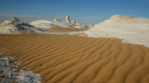
A main geographic attraction of Farafra is its White Desert a national park and 45 km north of Farafra, rock coloured snow-white to cream, massive chalk rock formations (ventifact) created by sandstorms.
More than 100 wells spread over Farafra, many natural and used to irrigate cultivated land. Bir Sitta, (well 6), Bir Sab’a (well 7) and Bir Ithnian wa ishrin (well 22) are the most important as they are warm and with a slight sulphur smell, good for swimming and relaxation. Abu Nus – a large touristic well 15 km north of the edge of the Farafra.
Gebel Babein southwestern corner XL. There are 149 named mountains in the New Valley Governorate. The highest and the most prominent mountain is Gebel Babein – 3563 feet
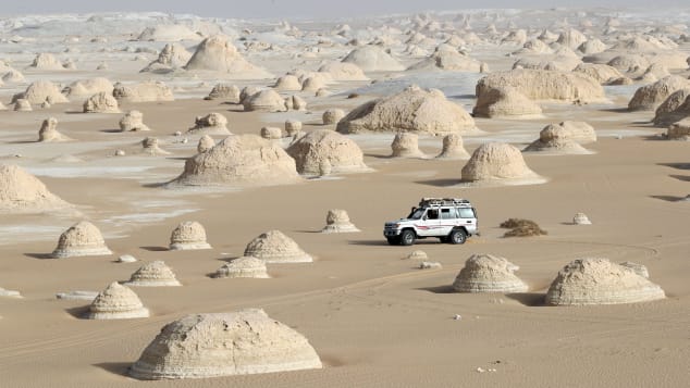
White Desert. 300-sq-km national park 20km northeast of Farafra, on the east side of the road, blinding-white chalk rock spires sprout from the ground, with unfamiliar shapes formed by the dry desert winds. These sculptural formations are best viewed at sunrise or sunset or under a full moon. The sand around the outcroppings is littered with quartz, deep-black iron pyrites and small fossils. On the west side of the Farafra–Bahariya highway, chalk towers called inselbergs burst from the desert floor into a spectacular white canyon. Between them run wide areas of sand.
About 50km north are two flat-topped mountains known as the Twin Peaks, a key navigation point for travellers. A favourite destination of local tour operators, the view from the top of the surrounding symmetrical hills, all shaped like giant ant hills, is spectacular. Just beyond here, the road climbs a steep escarpment known as Naqb As Sillim (Pass of the Stairs); this is the main pass that leads into and out of the Farafra depression and marks the end of the White Desert.
A few kilometres further along, the desert floor changes again and becomes littered with quartz crystals. If you look at the rock formations in this area you’ll see that they are also largely made of crystal. The most famous of the formations is the Crystal Mountain, actually a large rock made entirely of quartz. It sits right beside the main road some 24km north of Naqb As Sillim and is easily recognizable by the large hole through its middle.
At the time of writing, foreigners were officially no longer allowed to camp overnight in the desert, but in reality, many people do. The tourist police turn a blind eye, but it pays to do the trip with an experienced safari outfit. As well as the national park entry fee, you pay a LE20 fee for each night you sleep here. If you come as part of a group, the fees are included in your tour. You can usually buy tickets at the entrance to the park, but don’t worry about going in without one; you can just pay the rangers when they find you. Sleeping anywhere in the park, surrounded by the white formations and visited by friendly fennecs, is an unforgettable experience.
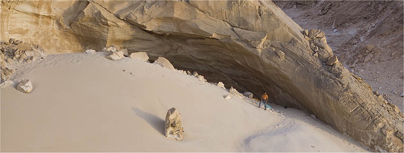
Cave of Swimmers. A cave with ancient rock art in the mountainous Gilf Kebir plateau of the Libyan Desert section of the Sahara. It is located in the New Valley of southwest Egypt, near the border with Libya.
The cave and rock art was discovered in 1933 and contains Neolithic pictographs and is named due to the depictions of people with their limbs bent as if they were swimming. The drawings include those of a giraffe and a hippopotamus. They are estimated to have been created as early as 10,000 years ago with the beginning of the African Humid Period when the Sahara was significantly greener and wetter than it is today. The cause of the climate change 10,000 years ago was due to changes in summer solar insolation and vegetation and dust feedback.
In 2007, an ancient mega-lake (30,750 km²) was discovered buried beneath the sand of the Great Sahara in the Northern Darfur region, Sudan.
It is questioned whether the figures are swimming or not and possibly symbolic…with an unknown meaning. The figures are deceased souls floating in the waters of Nun. Similar artwork is found in the nearby Cave of Beasts. The continuous line that the figures create extending across the cave’s interior has led researchers to believe that the cave art may display developing concepts later adapted to the configuration of the Nile valley.
Substantial portions of the cave have been irreversibly damaged by visitors over the years, especially since the film was released in 1996. Fragments of the paintings have been removed as souvenirs and some surfaces have cracked after water was applied to ‘enhance’ their contrast for photographs. Modern graffiti has been inscribed upon the wall and tourist littering is a problem.
Cave of Beasts is a huge natural rock shelter in the Western Desert featuring Neolithic rock paintings, more than 7,000 years old, with about 5,000 figures. The shelter is located in the Wadi Sura at the south-western foot of the Gilf Kebir Mountains in the remote south-western corner of Egypt’s New Valley near the border of Libya and Sudan. The area, abandoned in the present day, is one of the most arid locations of the Sahara.
 |
The shelter was discovered in 2002, some 10 km (6.2 mi) further west of the Cave of Swimmers (Wadi Sura I).
7,000 years ago, the Sahara’s climate was humid. In the Holocene period there was a lake at the foot of the shelter. At the end of the Holocene climatic optimum 6000 years ago, the climate pattern changed to arid and the area was depopulated.
The shelter is 17 m (56 ft) wide and almost 7 m (23 ft) high and contains over 5,000 well-preserved figures painted with red, yellow, white and black pigments. Hundreds of hand and foot stencil are over-painted with groups of human creatures and therianthropic and acephalic (headless) mythological creatures. Whereas the hand stencils can be found in many cave paintings all over the world, the beasts are unique. The shelter is upwardly topped off by rock engravings.
In 2016 a report concluded that the 13 small stencil hands were more likely made by humans using the hand of a monitor lizard as a stencil.
Many of the beasts were intentionally disfigured in prehistoric times. Always surrounded by human creatures, the beasts catch the eye due to their body size and shape: Long-tailed, bull-like body, frequently three-footed with human-like legs. Even headless they appear either to spit or to swallow human creatures.
The shelter is covered with groups of dancing, floating or swimming human creatures. On the lower left edge of the shelter appear two groups of human creatures separated from each other by a rock crack. The ones above the rock crack are holding a sling over his head, while the ones below the crack have a hand above their heads and are all looking to the left.
Scattered throughout the shelter appear wild animals: an elephant, ostriches, gazelles, and giraffes. Along with the beasts, the figures of the shelter represent a mythological world whose symbolism has not been deciphered yet.
