

ARUNACHAL PRADESH (Itanagar)
Apatani Cultural Landscape. Tentative WHS (15/04/2014). Ziro Valley is inhabited by the Apatani tribe one of the major ethnic groups of the lower ranges of the eastern Himalayas. It consists of 32 km2 of cultivable areas out of 1058 km2 of plateau, undulated by small hillocks (1525m) to mountains ranging from 1830 to 2900m.
The hallmark of the valley is judicious utilization of limited land area. The relatively flat land in the valley is used for wet-rice and fish cultivation. Millet reared on elevated areas between the rice plots. Efficient conservation of crucial watersheds ensures perennial streams. Soil fertility is sustained year after year by recycling crop residues and use of organic wastes of the villages.
The tribe is known for their colorful culture with various festivals, intricate handloom designs, skills in cane and bamboo crafts, and vibrant traditional village councils called bulyañ. Still many of the Apatani older men and women do have a tattoo on their face and beautiful nose plug. The real rituals and festivals occur in January and March. This has made Ziro Valley a good example of a living cultural landscape.
The Apatanis are among the few tribes in the world who continue to worship nature.
The traditional relations with other villages and neighboring tribes are unique and duties towards such relations are considered sacred.
Namdapha National Park. Tentative WHS (15/03/2006) is a 1,985 km2 park with more than 1,000 floral and about 1,400 faunal species, it is a biodiversity hotspot in the Eastern Himalayas.[1] The national park harbours the northernmost lowland evergreen rainforests in the world at 27°N latitude.[2] It also harbours extensive dipterocarp forests.
Thembang Fortified Village. Tentative WHS (15/04/2014). Monpas village within a fortified area of 3.2 Acres. The fortified Dzong is constructed using traditional technology. Dzongs, a type of fortress architecture that is found in Bhutan and Tibet.
55km north-east of Bomdila at 2169 m. The Dzong has two gates, composite stone masonry and wood architecture. Ornamental features include carved stone blocks, mani walls (stone walls with prayers engraved on them), traditional wood carvings, paintings and manuscripts, etched as murals and graffiti along the houses and ancient ruins.
There are 42 households in the village with a population of 250.
The predominant religion is Buddhism and ownership of properties is not individual but community ownership. The area adjacent to Thembang is rich with biodiversity and a wide variety of wild animals, including rare species such as Red Panda, are found in these forests.
Jawaharlal Nehru State Museum, Itanagar
World of Nature
Mouling NP
Pakke Tiger Reserve
Sonai Rupai Wildlife Sanctuary
Jung falls (Nuranang falls). 100 metres high, 2kms from Jang on the road connecting Tawang and Bomdila, The Nuranang river originates from the Northern slopes of the Sela Pass. Just below the waterfall it falls into the Tawang river.
Komsing Hanging Bridge, West Siang. Over the Kameng River, this bridge is made of cane and bamboo and 60 to 70 meters long. With some metal cable, the floor creaks and squeaks, the entire structures swings and balances under your steps. Below, between the bamboo weaving of the floor, some 30 meters down, the rivers flows loudly, leaving you breathless.
Indigenous Peoples:
Apatanis
Mishmis
Monpas
Nyshis
Singphos
TAWANG. At 3,048 metres, the area is part of the wider dispute between India and China concerning Arunachal Pradesh and is claimed by China as a part of the Tibet Autonomous Region.
Permit. Foreign Tourists in a group of 2 or more persons need to obtain 30-day PAP (Protected Area Permit) Govt. of India, Ministry of Home Affairs, New Delhi. The Resident Commissioner, Govt. of Arunachal Pradesh, Kautilya Marg, Chanakyapuri, New Delhi. Phone: 011-230113915/23013956/26880901; The Commissioner (Home), Govt. of Arunachal Pradesh, Itanagar- 791111.; Commissioner and Secretary (Tourism), Govt. of Arunachal Pradesh, Itanagar- 791111. USD 50
Application for PAP are to be applied through local approved tour operators only.
Tawang is 326 kms from Tezpur, 447 kms from Itanagar and 488 kms from Guwahati.
Tawang Monastery. A Tibetan Buddhist Monastery of the Gelugpa sect – constructed in 1681. It was the birth place of the celebrated 6th Dalai Lama, and is home to more than 500 lamas.
Tawang War Memorial was built in memory of soldiers of the Indian Army who gave up their life in the 1962 Indo-Sino War. Do not miss the evening Light and Sound show by Indian Army.
Bum La – The Bum La Pass is 37 km away at the Indo-China border above 16,500 ft above sea level. This is an old traders road went from Tawang via Milakatong La Pass (La in Tibetan is pass) to Bum La Pass and finally to Tsona Dzong in Tibet province of China. This area is heavily guarded by Indian Army and one need to obtain Protected Area Permit (PAP) to visit this place. PAP can easily be obtained from the local DC office with the help of travel agents in Tawang.
Jang Falls – A spectacular waterfall a km away from Jang.
P.T.Tso Lake – Above Tawang, frozen for 4-5 months of a year. Good views.
Sangetsar Lake – Above Tawang formed as a result of earthquake in 1971. One can see the remaining branches of pine forest on the lake. Also known as Madhuri lake, because Madhuri Dixit (a Bollywood actress) danced in this lake during the shooting of the movie Koila.
OTHER DESTINATIONS
M@P: Vijaynagar Telshil (Arunachal Pradesh extreme southeast)
XL: Arunachal Pradesh extreme east (Tezu)
DO
Trekking. Bomdila is a great option for adventure sports especially trekking. Best time to for trekking October to February.
Rafting Brahmaputra is one of the best rivers for rafting The Tsang Po River flows in the east side of Tibet, passing through great Himalayan. This river also passes through the Namche Barwa, highest unclimbed mountain and then reaches to Arunachal Pradesh. Brahmaputra river rafting is a challenging activity in which one can experience the “ Zebra ock” and “ Roaring Rikor”. Tourists can also set their camp on beaches in the night time.
Subansari River (“Gold River”) is the biggest tributary of the Brahmaputra and flows through rainforest 170 km in Tibet, 250 km in the east Himalaya and 86 km in Assam before it joins the great Brahmaputra River.
Kameng River flows on the India-Tibet border, one of most challenging rivers
++++++++++++++++++
NAGALAND (Kohima, Dimapur, Mon, Wokha)
KOHIMA (pop 100,000). The state capital was founded in 1878 when the British established its headquarters. Kohima was the site of one of the bloodiest battles of World War II, referred to as the ‘Stalingrad of the East’. Kohima lies on the foothills of Japfü range at 1,261 metres (4137 feet). It has the largest crucifix in India.
Nagaland State Museum.
Langpangkong Caves. Located near the towns of Tuli and Changtongya. Take cabs from Mokokchung town. Mokokchung is connected by many Nagaland state transport services buses to the nearby towns and cities; you can take a jeep from the bus stand or trek up to the caves.
Longwa Village. One of the largest villages of Mon district, the Angh’s house lies half in India half in Myanmar. Even though the village lies in two countries, the entire village is ruled by the chief. Four rivers flow through the village, two in India and two in Myanmar.
Khonoma Eco Village. A town belonging to the ‘Angami Naga’ ethnic group of Nagaland, Khonoma Village is located about 20 km from Kohima, Khonoma village is a Green Village, where all forms of hunting have been abolished, protect and conserve their natural habitat. The resident Naga tribes here are traditionally dependent on nature for their food and have strong hunting practices. However, they have given up on their centuries old heritage for a more sustainable way of life with nature.
Naga Heritage Village. Thatched roofs on traditionally built houses, its wooden walls and delicately and neatly done carvings of different designs. This village comprises of Morungs or 16 different houses that symbolize the 16 communities residing here. These communities have restored the artifacts of World War II, its food courts, traditionally bamboo made halls and a stadium which is famous for its Hornbill Festival.
Every year in the first week of December, this village celebrates the biggest festival of Northeast, The Hornbill Festival.
Hornbill Festival- (Naga Heritage Village – Kisama). Held in the first week of December. Each tribal Hoho (the leading body of each tribe) constructs a Morung (boys dormitory), where the values of life are traditionally imparted. Although they don’t have the original totem poles or carvings, the ceremony still serves to give an authentic idea of the traditions of the tribes. Traditional arts include paintings, wood carvings and sculptures . Naga troupes sing folk songs, perform traditional dances and play indigenous games and sports. Evening music concerts.
Ntangki NP
OTHER DESTINATIONS
Touphema Tourist Village. Tells the history, tradition and ancient myths of the Naga people. 41 km north of Kohima, the resort offer all the modern comforts with an ethnic setting. Guided walks to nearby peaks or rice fields, hunting trips, cultural expeditions and visits to local homes. Local dishes made with home made rice beer.
Museum ethnographic collection including wood carvings, musical instruments, textiles, handicrafts traditional artifacts, jewelry and archaeology.
Dzükou Valley. At 2438.4m behind Japfu Peak, 30km south of Kohima, the entire valley is overshadowed with a type of tough bamboo brush and a serpentine stream. Wild herbs sprout along the river banks.
From June to September, the entire valley is covered with a carpet of wild flowers. The valley is surrounded by hills, natural caves & rocks and is thus, ideal for camping. This is one of the best trekking spots in the North-Eastern Region.
Indigenous Peoples
Angamis
Aos
Khasis
Konyaks
DO. Visit the tribes, See the handicrafts and shawls, Go trekking and hiking, Try angling, River rafting. Rock climbing.
++++++++++++++++++
MANIPUR
Permit. There is no permit required for foreigners coming to Manipur, they only need to register themselves in the established check points i.e. Imphal Airport and (Mao and Jiribam) for those coming by road.
IMPHAL. is the capital city of Manipur. The metropolitan centre contains the ruins of Kangla Palace (Kangla Fort), the royal seat of the former Kingdom of Manipur, surrounded by a moat. Imphal West contains the majority of the city’s area and population.
Imphal Airport (IMF)
Manipur State Museum
Khwairamband Bazar
Shaheed Minar. Monument
Sadu Chiru waterfalls, Imphal West.
Keibul Lamjao National Park. Tentative WHS (11/03/2016). 40 km2 in area and the only floating park in the world, it is an integral part of Loktak Lake. It was created in 1966 as a wildlife sanctuary to preserve the natural habitat of the endangered Eld’s deer
The park is a swamp with floating mass of vegetation created by accrual of organic garbage and biomass with soil particles that has been thickened into a solid form called phumdis, at the south–eastern side of the Loktak Lake, which has been declared a Ramsar site. Two thirds to three fourths of the total park area is formed by phumdis. A waterway through the park provides year-round access by boats plying through the Loktak Lake, to the Pabot Hill in the north. The swamp encompasses three hills, namely, Pabot, Toya and Chingjao that provide a refuge for the large mammals during the monsoon season. The distinctive nature of the park is that it is “too deep to be marsh, too shallow to be a lake”. The monsoon drips 46.6 in with July and August as the wettest months and February and March as the driest.
The park is 53 km (32.9 mi) from Imphal and 522 km (324.4 mi) from Guwahati. Basic accommodation of a forest rest house without boarding facilities is available at Phubala and Sendra islands inside the park and at Moirang town 10 km (6.2 mi) away from the park. Staying at Imphal which has better hotel facilities is a preferred option.
A boat trip along the labyrinthine boat routes passing through colourful water plants is a good way to see the park. An adventurous trip would be to take a walk through the park but the phumdi is not a firm ground.
Lokchao Wildlife Reserve
Shirui NP
Khangkhui Khullen Mangsor Cave. A natural limestone cave with artefacts dating back to the Palaeolithic culture. It is about 15 km from the eastern side of Ukhrul town. The cave was used as a shelter by the local people during World War II.
Tangkhul Naga. Indigenous Peoples:
++++++++++++++++++++++
MIZORAM
Mizoram is full of beautiful and pristine places. Tourism is not promoted, there is no help reserving government accommodation and there are very few tour operators (Serow Tours). Mizoram does not have famous places/spots but come here to enjoy the weather, the raw nature around, the thick and unending forests, winding roads and overall scenic beauty.
AIZAWL (pop 300,000). This 112-year-old citadel-like city, with its timber houses and profusion of flowers is set on a ridge 4000 ft above sea level. Aizawl is a religious and cultural center of the Mizos. It has cloudless blue skies, dewy mornings, sunlit days, practically all year round.
Aizawl Airport (AJL)
Mizoram State Museum
Southern Mizoram (Lunglei). XL:
ReiekVillage is a model Mizo Village. There is a small trek through forest up the mountain with a cliff and view.
Murlen NP
Phawngpui Blue Mountain NP. Manipur, Assam and Tripura bind the northern end of the Blue Mountains with neighbouring countries Myanmar and Bangladesh. Evergreen ranges of Mizoram hills with blooms of exotic flora and dense bamboo jungles rise sharply from the plains of Assam in a north south direction. These hills and plunging gorges are criss-crossed by rivers and waterfalls. Highest among its several peaks is the Phawngpui (Blue Mountain) – extremely popular with trekkers and adventure enthusiasts. The Blue Mountain is 300 km from Aizawl and close to the Myanmar border.
Vantawng Falls. In thick bamboo forests close to Thenzawl hill station is Mizoram’s highest waterfall at 750 ft high. Located 152 km from Aizawl.
OTHER DESTINATIONS |
Tamdil (Tam Lake). Natural lake reputed for its fish and prawns. 85 km drive from Aizawl. Jungles, resort village of Saituai is just 10 km away.
Champhai. Fertile plains about 200 km from Aizawl with emerald rice fields bordered by the smoky hills of Myanmar, the biggest stretch of plains. 8 hours by SUMO.
Rihdl. Lake situated in Myanmar very near to the Indo-Myanmar border reached from Champhai. Catch an auto from Govt lodge to Champhai, then a shared SUV for Zokhawthar on the Indo-Burma border. Permit (10 rupees) from the Burmese outpost to enter Burma. The lake is a 1.5 km walk.
Lunglei. A popular hill station in the south.
Dampa Wildlife Sanctuary. A tiger reserve located in West Phaileng district and is 127 km from Aizawl. It is better to book the government lodge well in advance. You need the permit from forest officer staying in West Phaileng to enter Dampa forest. This can be done also from forest department in Aizawl. You should be careful while visiting the forest on a rainy day as it is infested with leeches. This Sanctuary has different types of birds and animals, like tigers and elephants.
Do. If you are an early bird, get up early in the morning and see the lakes of cloud all around the cities and towns as most of them are built on the mountain tops.
+++++++++++++++++++++++
TRIPURA (Agartala, Ambasa, Kailashahar)
ARGATALA
Agartala Airport (IXA)
Ujjayanta Palace.
Maharaja Bir Bikram College, Agartala (Main City)
Malanchya Nivas, Agartala (Main City)
Temple of Fourteen Gods, Old Agartala (Approx 15 km)
Rose Valley Park, Agartala (Outskirt of the city)
Akhaura Border, Agartala (Main City)
Pilak Historical Palace (Shyam Sundar Ashram). Vestiges of the Past. An archaeological site where many images and structures, belonging to Buddhist and Hindu sects, have been discovered here since 1927. The antiquities found here are dated to 8th to 12th centuries. Sandstone sculptures of the Pilak site, which represent a heterodox culture of Hinduism and Buddhism of 9th to 13th century, are on display at the Tripura Government Museum.
Pilak site is at Jolaibari, and is spread over an area of about 10 square kilometres (3.9 sq mi). It is 100 kilometres (62 mi) away from Agartala, 51 kilometres (32 mi) from Udaipur, Santibazar is 18 kilometres (11 mi) away, and 3 kilometres (1.9 mi) from Jolaibari.
It used to be a part of Samatata kingdom in historical Bengal. The earliest dates of Hindu and Buddhist sculptures, terracotta plaques and seals are between 8th and 9th centuries. Stupas built with bricks were found.
Unakoti. Vestiges of the Past. An ancient Shaivite place of worship with huge rock reliefs celebrating Shiva. in NE Tripura. It is Shiva pilgrimage and dates back to 7th – 9th centuries.


Shiva with the waters of Ganga flowing from his locks.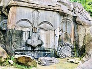
Close up of the sculpture of Shiva.
The images found at Unakoti are of two types: rock-carved figures and stone images. Among the rock-cut carvings, the central Shiva head and gigantic Ganesha figures deserve special mention. The central Shiva head known as Unakotiswara Kal Bhairava is about 30 feet high including an embroidered head-dress which itself is 10 feet high. On each side of the head-dress of the central Shiva, there are two full-size female figures – one of Durga standing on a lion and another female figure on the other side. In addition, three enormous images of Nandi Bull are found half-buried in the ground. There are various other stone as well as rock-cut images at Unakoti.
According to Hindu mythology, Lord Shiva once spent a night here en route to Kashi. 99,99,999 gods and goddesses followed him. He had asked his followers to wake up before sunrise and make their way towards Kashi. Unfortunately, none awoke, except Lord Shiva himself. Before he set out for Kashi alone, he put a curse on the others, turning them to stone. And that is how the site got its name. However, there are not that many sculptures found now. The place is peaceful & surrounded by lush greenery.
A big fair Ashokastami Mela is held in April.
Unakoti lies 178 km to the northeast of Agartala, the closest airport, 8 km to the east from Kailashahar, 148 km to the south-east from Silchar. The nearest railway station is 19.6 km away at Dharmanagar, then 30–40 minutes by car. The morning train from Agartala reaches Dharmanagar before 10 am and the afternoon train at 8 PM
OTHER DESTINATIONS
Tripura southwestern Panhandle. XL
Rajbari NP (Trishna Wildlife Sanctuary)
Neermahal Palace, Melagarh (Approx 50 km)
Maata Bari temple, Udaipur (Approx 60 km)
Bhubaneswari Temple, Udaipur (Approx 60 km)
Jampui Hills, North Tripura (Approx 200 km)
Pilak, South Tripura (Approx 100 km)
Kamalasagar, Kashba (Approx 40 km)
Tripura Sundari Temple (Matabari). Its one of the sakthi peeda.