
Sardinia August 10-12, 2021
I came to Sardinia primarily to get one of my last Nomad Regions in Europe and to see the WHS of Su Nuraxi. Sardinia itself has little interest to me. The Sardinia tourist map lists 68 beaches and nothing else. Interestingly the videos broadcast in the airport show no beaches but things most tourists never see. The other NM sites were also not interesting and I saw none.
I had wanted to take my van and a ferry but most ferries were booked out, almost impossible to navigate (many ports and companies, most a long drive from Turin) and very expensive (178E one way for the 5 ½ trip). I then got a last-minute flight from Turin on Volotea (120E return). I had not filled in the online check-in form and it cost a whopping 40E to do the one-minute form. I made sure to do it on the return.
After all the disasters in Spain, the Cagliari Airport is very functional and nicely airconditioned. Landside has a full market with good prices and a selection of reasonable restaurants including a McDonalds (I never eat at McDonalds at home and use them in Europe as a wifi source and toilet).
The only way into Cagliari is via the train, a short ride. Don’t follow the signs but exit arrivals and follow the curve of the road right past the parkade. There are ticket dispensers at arrivals and below the station. The train and bus stations are next to each other.
The heat and humidity were oppressive.
I had forgotten the Europe adapter for my computer and went by public bus to the Apple dealer in NE Cagliari. I think Apple is built for obsolescence as they had none. The fellow gave me an ancient adapter attached to a cord for free. I had not bought a return ride and it is not possible to buy tickets except at the central bus depot. This bus even had a “conductor” to check tickets. I offered cash but he didn’t even wait for the next stop to kick me off instantly cussing me. I had a walk in the heat. This part of Cagliari is depressing with worn architecture and peeling paint. There were more dog turds than people. I took a few wrong turns and ended up in the nice, tourist zone centred for a few blocks around the square and just a few blocks north of the station. The multitude of sidewalk cafes were busy and packed with tourists and locals. Cagliari appears to have a reputation as a food destination beside the beaches. The architecture is nice typical European.
I then returned by train to the airport to eat and sleep, finding a great quiet, dark place. McDonalds was closed but the nice lady took pity on me and gave me a large fries for free, my second free thing of the day!
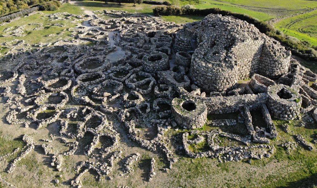
Su Nuraxi di Barumini. This WHS archaeological site is located in central Sardinia, one of about 30 nuraghi in Sardinia and the best example. It sits on a hill overlooking a vast and fertile plain, and represents the most famous example of the Bronze Age defensive complexes characteristic of the island known as nuraghi. Built in the second millennium BC and occupied until the third century AD, the Barumini nuraghe consists of the characteristic massive central truncated cone tower, originally more than 18 meters high, made with very large stones arranged dry in overlapping concentric circles that tighten towards the top. The building was intended for a single family but subsequently, following the political and social evolution of the island, the tower was incorporated into a structure consisting of four towers joined by a stone wall and with the courtyard covered by a roof.
The Nuragic civilization played an important role in the diffusion of the Mycenaean culture and, later, of the Phoenician one, even if some of its peculiarities, perhaps because they are foreign to classical Greek culture, remain shrouded in mystery.
To get here cheaply is very limited. Trains don’t go. One bus leaves at 14:30 (Laconi), transfers at Sanluri after 1’13’, arrives at Barumini with about 1.5 hours to see the site and leaves Barumini at 17:30. Same buses on return 4.90€ each way.
After returning, I had a pizza in a restaurant around the square, took the train back to the airport and went to sleep early to catch my 6 am flight back to Turin.
My next destination is the long drive through south France, Spain, Portugal, France, Belgium and finally Amsterdam to sell my VW California at My California where I had purchased it. Using it is much more limited than expected – the specific butane tanks cannot be purchased in Scandinavia or Eastern Europe. My original plan was to drive it from Cairo to Cape Town but that is impossible because of the butane issues, high sulphur diesel (instantly plugs the diesel particulate filter, 3,500 E to replace) and would require I fill the van with Ad Blue, not available in all of Africa until South Africa.
I have travelled extensively through all countries (most my third trip) and this trip was only orientated to visiting all the WHS I had previously missed. I have unlimited time and insurance on the van till October 30 but hope to complete it all in 3-4 weeks. After driving it 180,000 km to see every country in Europe and western Asia, it felt like home.
ROUGH GUIDE
Sardinia. An autonomous region of Italy, with its quintessential Mediterranean beauty, is mainly loved for swimming, boating, windsurfing, hiking, climbing, and camping. Coastal areas are over visited, especially in August. The inner island sees far fewer tourists. The ancient Nuragic civilization of Sardinia of ca. 1500 BC, whose stone monuments still dot the land, predates even the Etruscan civilization in mainland Italy by several hundred years.
In the 2010s, hiking and archaeological tourism with a low environmental impact has developed considerably: Giants of Mont’e Pramma.
Population is small – 1,650,000 inhabitants in 2010 and heavily concentrated in Cagliari (one-third of the total population) and Sassari (one-fifth). Olbia also has 50,000 inhabitants.
Climate. Mediterranean climate – dry, hot summers, autumn warm till late November, winter mild but cool at higher elevations and snow is generally limited to the Gennargentu range. The east is drier (but has the worst rainstorms). The western coast is rainy.
Can be very windy from September to April (northwest winds called locally Maestrale); southeast winds (Scirocco) are frequent during summer and bring invariably hot weather.
Terrain. The island is aseismic and non-volcanic. The second largest island in the Mediterranean (24,090 km² [9300 sq mi]), with spectacular beaches and mountain vistas.
The island’s interior is dominated by the Gennargentu Range, culminating at Punta La Marmora, 1834 m [6017 ft], Monte Limbara, Monte di Ala’, and Monte Rasu (all below 1500 m [4900 ft]). The Sulcis-Iglesiente stretches across southwestern Sardinia, peaks at 1236 m [4055 ft], and once had significant mining.
Plains are rare and small except for The Campidano Plain (the largest flat area from Oristano to Cagliari. Coasts are generally rocky with many cliffs, especially along the east.
History. Nuragic civilization (ca 1500 BC) whose cylindrical towers (called Nuraghes, sing. Nuraghe) dot the Sardinian landscape. One of the largest of these Nuraghe is near Olbia and the Costa Smeralda. Other fortified villages can still be found, a great example of which is Barumini (Medio Campidano province).
The Phoenicians arrived around 1000 BC and founded Cagliari (Karalis, ca 800 BC), Tharros (near Oristano), Nora (near Pula, Cagliari province), and others. First Punic War between Carthage and Rome, but went eventually to the latter. Rome had often trouble dealing with the rebellious locals but managed quite a large income out of grain and metal mining.
With the fall of the Roman Empire, heavy raiding of the coastal areas by Barbary pirates forced the population to the hinterland; Sassari for instance was founded by refugees from Porto Torres. Colonized (except for the Kingdom of Arborea) by Pisa and Genoa. From the early 1400s to the early 1700s, the island was Spanish. Sardinia was ceded to the House of Savoy in 1720. After the Savoys left, the only exploitation was ancient woodland and large mineral resources. In 1948 granted a limited degree of administrative autonomy that retains to the present day. Sardinia is slowly converting itself into a popular tourist destination even though traditional stock-herding, especially of sheep, is still a frequent sight.
Language. Italian (Italiano), Sardinian (Sardu) is the indigenous language and one of the most Latin-like Romance languages. It is not a dialect.
Get In. By plane. Flights to Milan and Rome on Jet2.com, Wizz Air, Ryanair, Easyjet and Eurowings. By boat. Ferry to Cagliari, Porto Torres (north coast), Olbia, Golfo Aranci and Arbatax (east coast).
Get Around. SardegnaMobilità, a public transportation portal with a travel planner.
By bus. Regular, cheap buses between the main centres.
By train. Regular between Sassari, Olbia and Cagliari.
By car. To visit some of the more remote areas. There are no toll highways in the island. Besides the main axes, other roads of great interest for tourists are the SS133 (Tempio Pausania-Palau) or the Chia-Teulada ‘panoramica’.
Many roads are narrow and wind through hilly terrain so use your car horn to signal your presence. Many villages have installed speed traps at the entrances and fines are heavy.
DO
Sardinia appeals more to nature lovers than to clubbers except the Costa Smeralda area, one of the ‘hot spots’ of the Italian show-business jet set.
Sea: sailing is popular in the Costa Smeralda area.
Islands: Asinara National Park (famous for its Albino Donkeys). Maddalena archipelago, Sant’Antioco (connected to the mainland since Roman times) and San Pietro (a community of Genoese fishermen) in the south.
Beaches and coasts. North and northeast (from Stintino to Budoni) have many beautiful beaches. The east: Cala Gonone, Arbatax, Muravera and Villasimius. The deep south (Chia, Pula). The west coast is very different with large beaches kilometres long (Porto Pino, Marina di Gonnesa, Marina di Arbus). Piscinas (Marina di Arbus) has 60-m-tall sand dunes. Alghero area is renowned for its underwater caves and grottoes for divers.
Hills and ‘mountains’: the terrain is steep, snow falls in winter, and there are 4 ski resorts in the Gennargentu area. Hills are everywhere in Sardinia, from the northeastern Monte Limbara Range to the Iglesiente area in the southwest, even on the outskirts of Cagliari. Everyone generally fills the beaches leaving the rest nearly deserted. Climbers like the Domusnovas area (close to Iglesias), with its nice vertical walls of limestone. Caves (Dorgali, Oliena, Santadi, Domusnovas, Fluminimaggiore, Alghero). Many hiking trails.
Festivals. Even small centres have local celebrations where people dress in rich traditional costumes. The major venues include Sant’Efisio (Cagliari, 1 May, actually lasts several days), Sagra del Redentore (Nuoro, last Sunday of August), Cavalcata sarda (Sassari, penultimate Sunday of May, horse parade and races), Faradda di li candareri (Sassari, 14 August), Sa Sartiglia (Oristano, Carnival period, horse races), S’ardia (Sedilo, 6 July, horse races) and everywhere the celebrations during Carnival and the Holy Week.
Food. Restaurants are closed between 16:00 and 19:00. Culurgiones (raviolis made with typical pasta, potatoes, ‘Pecorino’ cheese, egg, onion, mint and garlic. Malloreddus (gnocchi served al dente with a tomato, meat or cheese sauce. Porcheddu (young pig roasted over a wood fire with an aromatic local shrub called mirto). Salsiccia di cinghiale (wild boar sausage). Stufato di Capretto (casserole of kid goat, artichokes, wine and egg.
Pecorino (sheep cheese with all degrees of ripeness. Fainé (chickpea flour pancakes.
Seada (ravioli like dessert with fresh cheese and lemon rind, fried and served with honey. Sardinian bread and pastries. Carasau (a type of thin crispy bread), sponge biscuits and almond pastries. Sardinian pastry uses pig lard for fat and honey for sugar.
Torrone (nougat with honey, almonds, hazelnuts, and walnuts).
SEE
Su Nuraxi di Barumini. World Heritage Sites. During the late 2nd millennium B.C. in the Bronze Age, a special type of defensive structure known as nuraghi (for which no parallel exists anywhere else in the world) developed on the island of Sardinia. The complex consists of circular defensive towers in the form of truncated cones built of dressed stone, with corbel-vaulted internal chambers. The complex at Barumini, which was extended and reinforced in the first half of the 1st millennium under Carthaginian pressure, is the finest and most complete example of this remarkable form of prehistoric architecture.
The archaeological site of Su Nuraxi di Barumini in Sardinia is the best-known example of the unique form of Bronze Age defensive complexes known as nuraghi. The elevated position of Su Nuraxi dominates a vast and fertile plain. The site was occupied from the time of construction of nuraghe in the 2nd millennium BCE until 3rd century CE.
Megalithic defensive structures known as nuraghi date from the Middle to Late Bronze Age (c. 1600-1200 BCE), and are unique to Sardinia. Nuraghi are characterised by circular defensive towers in the form of truncated cones built of dressed stone with corbel-vaulted internal chambers. Nuraghi are considered to have initially been built by single families or clans. As Sardinian society evolved in a more complex and hierarchical fashion, there was a tendency for the isolated towers to attract additional structures, for social and defensive reasons.
The Su Nuraxi nuraghe consisted of a massive central tower of three chambers connected by a spiral staircase, originally over 18.5 metres high. The uppermost chamber is no longer standing. The central tower was enclosed within a quadrilobate structure consisting of four subsidiary towers linked by a massive stone curtain wall. The courtyard created by this wall was later sealed with a roof thereby restricting access to the central tower. Surrounding this are the remains of the second outer wall and a settlement of circular huts.
Su Nuraxi was abandoned in the 6th century BCE although intermittent occupation took place in subsequent centuries. New houses were constructed in a different form from their predecessors, consisting of several small rooms and constructed using small stones. Following the Roman conquest of Sardinia in the 2nd century BCE most nuraghi went out of use although excavations at Su Nuraxi indicate that people continued to live on the site until the 3rd century CE.
Nuragic Sanctuary of Santa Vittoria. Vestiges of the Past
Sulcis Iglesiente. Tentative WHS (01/06/2006). A geographic area located in the extreme southwest of Sardinia and is famous for its ancient origins and traditions. Already inhabited 5,000 years ago, the zone was favoured by the Phoenicians and Carthaginians, the first to discover and extract its rich mineral deposits. Largely abandoned in the successive centuries, these deposits constitute a significant testimony to industrial archaeology.
Untamed and pristine landscapes characterize this Sardinian territory from the Natural Park of Sulcis to the famed Pan di Zucchero (near Iglesias), from the Porto Pino pinewood forest to the Gulf of Palmas, from the salt mines of Sant’Antioco to the Island of San Pietro (called the “green island” for its lush and thriving plant life).
Water and nature lovers can swim, stroll along the Gulf of Gonnesa, the beach at Portixeddu, surf, kitesurfing, windsurfing, diving, and sailing – all in an area so rich in winds.
Archaeological finds from the Nuragic, Phoenician, Roman and Byzantine civilizations In Villaperuccio is the necropoli, Domus de Janas – the so-called “House of the Fairies (or Witches)” – of southern Sardinia: tombs dug into the rock here date back approximately 5,000 years. Many are the sites that contain evidence of Punic settlement in the region, like the Phoenician fort of Pani Loriga near Santadi and, first among them, the city of Sant’Antioco (formerly Sulcis), which holds a collection of several finds from the successive eras.
Monte Siraiis a Punic, fortified center constructed atop an ancient Nuragic settlement. Antas has many temples especially the majestic Punic-Roman Temple, built on the ruins of a Carthaginian place of worship.
Walk through a mineral park, a boat ride and a swim in the sea, and taste tuna, oil, pecorino or sheeps’ cheese, artichokes and honey, accompanied, of course, by a nice glass of Carignano DOC from Sulcis.
SAN PIETRO
SANT’ ANTIOCO
ASINARA
Island of Asinara. Tentative WHS (01/06/2006) XL. In northwest Sardinia has the National Park of Asinara. Area 51,9 square kilometres, length of 17,4 km and a width of 290 meters of Cala di Sgombro to 6.4 km of the northern part; 110 km long coast: highest point 408 metres (Punta della Scomunica).
The marine area is protected. Rare black anfiboliti erciniche that are 950 million years old, being the oldest rocks in Italy.
Look for “domus de ianas” (sprites’ houses) built inside soft limestone, unique in the island, by Campu Perdu. Asinara visited by Phoenicians, Greeks and Romans; in the middle age monks from Camaldoli settled in there devoting themselves to agriculture.
In late ‘700, shepherds from Sardinia and Liguria colonized the island till 1885 when all the 500 inhabitants had to move away to let the isle becoming a penal colony and a quarantine station (as decided by King Umberto di Savoia). During the great War it was a concentration camp for thousands of Austro-Hungaric soldiers, and 5000 soldiers died on the island and were buried in a dedicated charnel house. In the 70’s it become a high security prison for convicts for organized crimes, also imprisoning the most dangerous criminals of red brigades, Sardinia anonymous and mafia.
Asinara NP
MADDALENA ARCHIPELAGO
Archipelago of La Maddalena and Islands of Bocche di Bonifacio. Tentative WHS: (01/06/2006). The national park of the archipelago of La Maddalena is located on the strait of Bonifacio, between the islands of Sardinia and Corsica. The seven main islands – Maddalena, Caprera and Santo Stefano in the South East, while Spargi, Budelli, Razzoli and Santa Maria are in the Northwestern area – and 55 little islets. Each islet is surrounded by a 300 to 500-meter protected marine area with 180 km of coastal area.
The area was included within the Cetacean Sanctuary, due to frequent sightings of cetaceans in autumn and springtime.
The flora has 750 different species. The benthic marine community is relatively untouched – the Mediterranean limpet, indicator of highly oxygenated and clean water is quite common over the archipelago’s coasts. On an important trans-Sahara transmigration route, a resting and breeding place for marine birds.
Ponds in the Bay of Oristano and the Sinis Peninsula island of Mal di Ventre. Tentative WHS (01/06/2006). On the west coast, it includes the entire coastal area of the bay of Oristano from the ponds of Pauli Maiori, the town of Arborea and the ponds of Corru s’Ittiri, S. Marceddi and S. Giovanni, and the overlooking island of Mal di Ventre (8 km from the coast, 80 hectares; flat with the highest 18 m.
It includes Tharros with evidence of long-lasting human settlements: The eneolithic culture of Bonuighinu in the IV millennium, the Nuragic culture, the Punic and Roman age and the Byzantine period.
Arborea was essentially intact and created between 1920 and 1930 as a service centre of the land.
Accommodation. Better are local hotels, a bed and breakfast or a holiday apartment. Rent a small cabin in a camping village or a room in an ‘agriturismo’ farm or rural cottage. Stay safe. Summer is hot and the sun strong so watch for heatstroke and sunburns. From May to September, water scarcity is serious. Winter and spring have pleasantly mild weather. The west is very windy from September to April. Some open-sea beaches have strong underwater currents and large waves.
Respect. Sardinians are generally quiet and reserved, different from the archetype of the outgoing and talkative Mediterranean.
