
SLOCAN VALLEY RAIL TRAIL 49.70km
Following the Columbia & Kootenay Railway line between South Slocan and Slocan City, this multipurpose trail allows only non-motorized traffic: walking/hiking, horse riding, cross-country skiing, mountain biking, and snowshoeing.
HISTORY
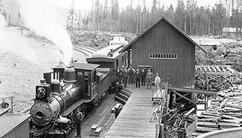
Massive railroad development flourished in the Slocan Valley region through the 1880s and 1890s as the drive to access huge deposits of gold, silver, lead and copper drove competing rail companies to jockey for the prime positions. Rivalries persisted along the rail routes and American Daniel Corbin – who built the Spokane Falls and Northern (SF&N) Railway in 1890, just 24 kilometres south of the Canada/US border at the Columbia River- intensified competition by building his railroad further north into Canada. In 1893, Corbin’s trail was completed with the Nelson and Fort Sheppard (N&FS) Railway, which created an uninterrupted rail line from Nelson to Spokane and allowed American interests to take the rich ore out of British Columbia.
The Canadian Pacific Railway (CPR) reacted swiftly by obtaining charters for several railways, to enable ore to be taken out of the Kootenays to the main line of the CPR which lay to the north. One of these charters established the Columbia & Kootenay Railway which was designed to take the rich ore north from Nelson to Slocan City where it would be barged to Rosebery. From there, the Nakusp & Slocan Railway would carry the ore to a smelter in Revelstoke. Unfortunately, the smelter could not be maintained and was eventually closed. This made the railway ineffective in reversing the flow of ore to the United States and resulted in the CPR’s building the Columbia and Western Railway from Castlegar to Midway to connect to the famed Kettle Valley Railway and eventually the CPR Main Line. The Columbia and Kootenay Railway soon became known as “a railroad from nowhere to nowhere”. The last train travelled the Slocan Valley rail line on September 14, 1993.
The Slocan Valley Heritage Trail Society (SVHTS) was formed in 1994 to create this Rail Trail as a non-motorized recreational corridor. The CPR right-of-way was gifted to the TCT in 1999, who turned it over the following year to the Province of British Columbia and the Ministry of Tourism. In 2002, our organization entered a 10-year stewardship agreement with Tourism, to act as managers of the rail trail on their behalf.
When the CPR abandoned the line, they had to remove the rails and ties, as well as dismantle bridges. The trail had to be built from the bottom up. Over the next several years, with the help of the province and federal funding, the rail trail began to take shape – which included rebuilding 4 bridges, grading the trail, putting down hundreds of truckloads of surface material, building trailheads, parking lots, kiosk signage etc. In 2017, the southernmost 4 km of the Rail Trail was developed into a paved community “Greenway”.
SLOCAN VALLEY to CRESCENT VALLEY – 5 km
This southernmost terminus section of the trail is the South Slocan Community Greenway with a paved 4 km surface. It is accessible to all fitness levels and links the communities of South Slocan and Crescent Valley, a connection to the Trans Canada Trail (TCT) and to Crescent Valley Beach Park.
Trailhead: at the end of South Slocan Station Road below the Dam Inn off Hwy 3A adjacent to the Dam Inn Restaurant. The new 50 m-long Greenway tunnel allows safe passage under the highway. The CPR mainline is still south of the trailhead, so be aware trains may be passing by.
About 1.5 km along the trail emerges from the forest in the vicinity of Mount Sentinel Secondary School into a residential area. After another kilometre, pass above Brent Kennedy Elementary School.
Pass through dry fir and pine forests and open views overlooking the lower Slocan Valley. Immediately below a gas station, outdoor adventure store, organic food store, cafe and restaurants and Crescent Valley Beach Park. This park was once an active sawmill in 1907. It was run by the Patrick Brothers, who went on to fame in the NHL.
From here the trail crosses the highway just north of the Crescent Valley bridge and arrives at the Crescent Valley trailhead.
CRESCENT VALLEY to PASSMORE – 16.5 km
The Crescent Valley section of the trail is very popular, particularly in the winter ski season. The main reasons for this popularity are ease of access; great scenery and access to some beautiful secluded beaches and shorelines.
Long forested sections that are very peaceful and quiet with frequent glimpses of the river. At km 7, the trail hugs the river in one of the most scenic, secluded stretches of the trail as it passes below the historic Kosiancic farm with views, river channels and islands.
At the south end of Slocan Park, the trail diverges away from the river and the valley opens up Slocan Park has a store, coffee shop, garage, and artisan studios. There is a small parking lot for trail users located at each end of the Slocan Park stretch.
Reconnects with the river again, the trail takes a more direct route and then hugs the steep shoreline to the Passmore Slide. The slide occurred in April of 2000 when a large unstable area crashed across the highway temporarily blocking the Slocan River and destroying a popular community beach. It destroyed the rail grade and created what is now the only “hill” on the Slocan Valley Rail Trail. Two benches here.
North of the slide, the river makes another great swing across the valley. The trail continues through mature forest and then open flats next to the river. This clearing is the site of the old Passmore sawmill but the area is now developing into a pleasant riverside residential neighbourhood. Less than a kilometre north the trail crosses Passmore Upper Road to reach the Passmore trailhead.
PASSMORE to WINLAW – 10.1 km
Shortly after starting out you’ll arrive at the confluence of the Slocan and Little Slocan Rivers. Docile most of the year, the Little Slocan can turn into a raging torrent in the spring. Looking beyond the Little Slocan you look up at what the locals call Frog Peak.
Continuing north along the river, pass small log jams, pilings from former, and long since forgotten riverside mills, marshlands active with nesting waterfowl, and more hidden beaches.
Paralleling the highway the trail then reconnects with the river. This area was at one time a thick cedar forest which has long since been converted into open fields. About 2 km north of here you’ll pass a variety of fish habitat structures installed by the Columbia Power Corporation. The structures were installed in 2005 to provide a safe haven for the juvenile trout population along the river. “Winlaw Station” was built in the style of the CPR station buildings of the day.
WINLAW to LEMON CREEK – 12.0 km
Winlaw was once a thriving mill community back in the 1920s and 30s and now boasts restaurants, stores, and shops nearby. Winlaw Regional and Nature Park across the river. A delightful location for a picnic or a swim (in season) – but notorious for mosquitoes. Pass below the local golf course.
Perrys Siding trailhead. Local beach 150m west of the road crossing and a bus stop and a bus with a bike rack!
The trail then meanders along a slow-moving portion of the river, opposite another rich waterfowl habitat area known locally as ‘the oxbow’, which can be navigated by kayak or canoe during high water.
Lemon Creek Internment camp – Between 1942 and 1946, at the north end of a pasture and less than 1km south of the Lemon Creek trailhead, a whole ‘town’ of simple wooden shacks with streets and gardens, a school and everyday life. this was the site of the that housed hundreds of Japanese Canadians. The farm on the west side – a dairy and hog farm at the time – was operated by the internees. A commemorative plaque was placed along the Rail Trail in 2012 to recognize this event. The trail then enters a heavily wooded area, ending at our next trailhead.
LEMON CREEK to SLOCAN LAKE – 8.1 km
At Lemon Creek, the old train bridge has been re-decked and railed to handle bicycles, hikers, skiers and horses instead of the trains it once carried. The last train crossed this bridge in 1993.
The ‘pilings’ in the river are wooden posts that were pounded into the river bed about a century ago to guide the logs that were floated down the river to small sawmills.
For several thousand years, native villages dotted the shorelines between here and Lemon Creek, canoes plied these waters harvesting the salmon that spawned here until the early part of the 20th century when dams on the Columbia River system prevented their migrations. Evidence of the pit-house dwellings dot the shoreline. Look for the interpretive display 1.5 km north of Lemon Creek.
After passing through the “Slocan Narrows” you reach the Walter Clough Wildlife area. In the spring and fall, geese, ducks and other waterfowl rest here on their migratory journeys. In winter this area can be the home of hundreds of trumpeter and tundra swans, geese and ducks because of the easily accessible food the river marsh offers. It’s a drawing card to winter skiers who show up by the score.
Pass pastures with grazing horses, then the Popoff Farm Internment Camp on the east side. Between 1942 and 1945. this housed thousands of Japanese Canadians forcibly relocated to the Kootenays in 1942. A commemorative plaque was placed here in 2012, as at Lemon Creek, to recognize this sad part of our history.
Heading north, a wide bay of the Slocan River often has waterfowl, herons, beaver, river otters and deer amongst farms and wetlands against the backdrop of Valhalla Park.
Owl Walk. Habitat for the Western Screech Owl with pathways, signs, covered amenity area and picnic area.
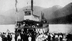
Village of Slocan. End the rail trail at the Gazebo on Slocan Lake. From this lakefront, CPR train cars were once loaded onto barges to connect to the rail line about 25 km north at Rosebery. Until the 1920s, a paddle-wheeler docked here and was the only transportation connection between the communities on Slocan Lake. Huge pilings are all that remain of that era and are a playground for swimmers in the summer.
EXAMPLE TRIPS
Summer Bicycle Trip. The annual KMC bike trip on this trail follows the following route/itinerary: 41 kilometres, 5 hours with 3 stops. This route avoids a shuttle or repeating any section of the route.
• Park at the Slocan Valley Rail Trail Passmore Trailhead,
• Cross the bridge and turn right to go up the paved Back Road (follow this all the way to Perry Siding).
• Winlaw Nature Park: Just north of Winlaw, break here (on the west side of the river).
• Perry’s Back Road crosses back to the east side of the Slocan River and ends at Perry’s Siding
• Rejoin the rail trail heading south.
• Stop for lunch at a convenient river-side location.
• Coffee/snack break at Sleep Is For Sissies.
Winter Cross Country Ski Trip – Swans.
Park at the Lemon Creek trailhead of the rail trail. Cross the old train bridge. Interpretive displays are on the pilings in the river (guided logs floated down the river) and native Canadian heritage. Just after the “Slocan Narrows” reach the Walter Clough Wildlife Area. In the spring and fall, geese, ducks and other waterfowl rest here on their migratory journeys. In winter, it is the home of hundreds of trumpeter and tundra swans, geese and ducks because of the easily accessible food the river marsh offers. It’s a drawing card to winter skiers who show up by the score.
References:
Slocan Valley Heritage Rail Trail Society (www.slocanvalleyrailtrail.ca)