
OHIO
In the East North Central region of the Midwestern United States, it is the 34th largest by area, the seventh most populous, and the tenth most densely populated. The state’s capital and largest city is Columbus. Ohio is bordered by Lake Erie to the north, Pennsylvania to the east, West Virginia to the southeast, Kentucky to the southwest, Indiana to the west, and Michigan to the northwest.
The state takes its name from the Ohio River, which in turn originated from the Seneca word ohiːyo’, meaning “good river,” “great river,” or “large creek. “Partitioned from the Northwest Territory, Ohio was the 17th state admitted to the Union in 1803 and the first under the Northwest Ordinance. Ohio is historically known as the “Buckeye State” after its Ohio buckeye trees, and Ohioans are also known as “Buckeyes. ”
Ohio rose from the wilderness of Ohio Country west of Appalachia in colonial times through the Northwest Indian Wars as part of the Northwest Territory in the early frontier, to become the first non-colonial free state admitted to the union, to an industrial powerhouse in the 20th century before transitioning to a more information and service based economy in the 21st.
Politically, Ohio is known for its status as both a swing state and a bellwether in national elections. Ohio is an industrial state, ranking 8th out of 50 states in GDP (2015). It is the third largest US state for manufacturing and the second largest producer of automobiles behind Michigan.
OHIO SOUTH (Columbus, Cincinnati, Dayton, Athens)
COLUMBUS (pop 893,000, metropolitan 2,106,541)
Columbus is the state capital and the most populous city in Ohio. Named for Christopher Columbus, the city was founded in 1812, at the confluence of the Scioto and Olentangy rivers, and assumed the functions of state capital in 1816.
The city has a diverse economy based on education, government, insurance, banking, defence, aviation, food, clothes, logistics, steel, energy, medical research, health care, hospitality, retail, and technology. The metropolitan area is home to the Battelle Memorial Institute, the world’s largest private research and development foundation; Chemical Abstracts Service, the world’s largest clearinghouse of chemical information; NetJets, the world’s largest fractional ownership jet aircraft fleet; and Ohio State University, one of the largest universities in the United States.
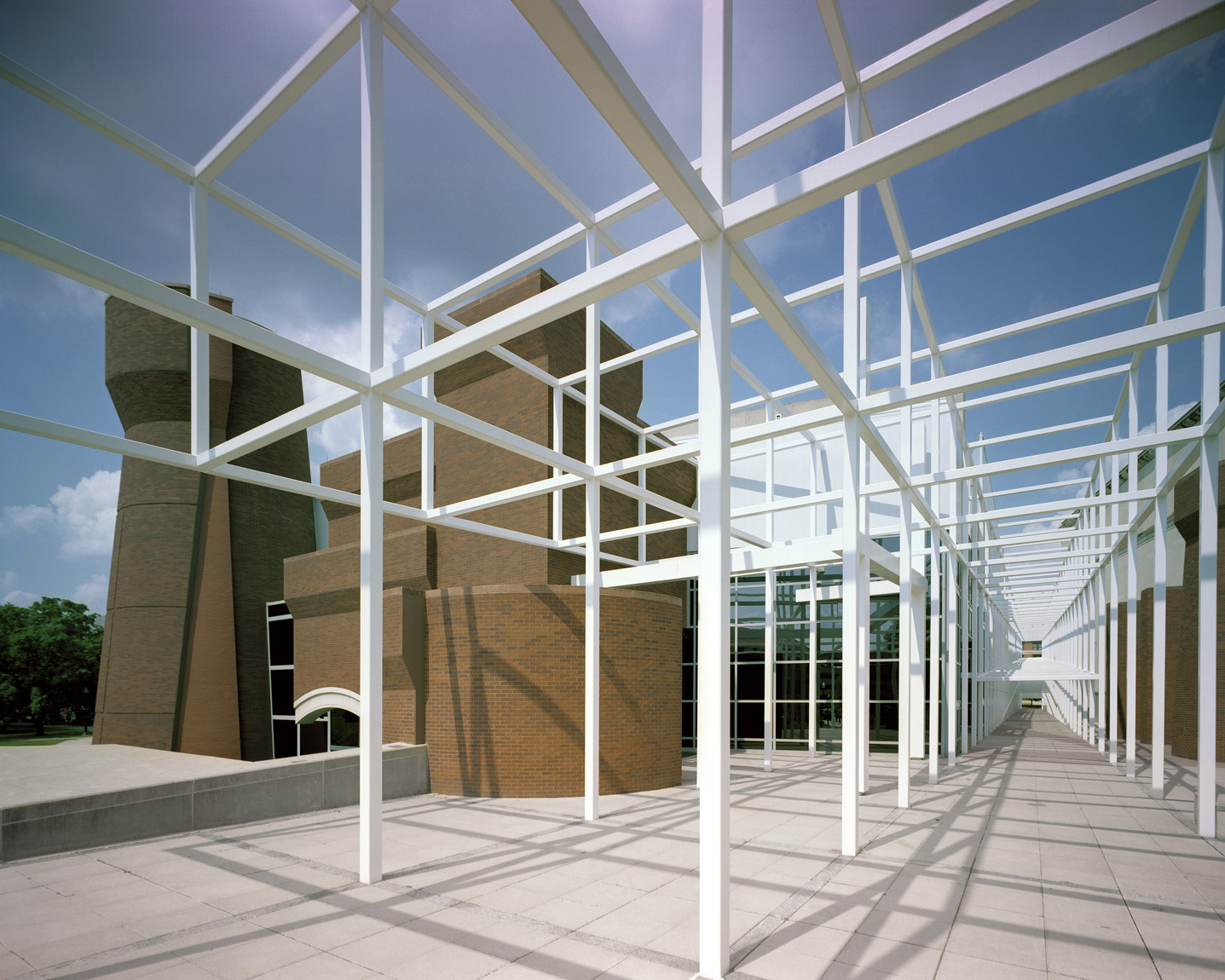
Wexner Center for the Arts. In the NM “Modern Architecture Buildings” series, this is Ohio State University’s “multidisciplinary, international laboratory for the exploration and advancement of contemporary art.” The Wexner Center opened in November 1989 and was named in honour of the father of Limited Brands founder Leslie Wexner, a major donor to the Center.
The Wexner Center is a lab and public gallery, but not an art museum, as it does not collect art. However, when the Center was constructed, it replaced the University Gallery of Fine Arts and assumed possession and stewardship of the University Gallery’s permanent collection of roughly 3,000 artworks. The collection serves a secondary role in the Center’s visual, media and performing arts programs. While it is made available to University students and scholars for study, and occasionally drawn upon for exhibitions at the center or elsewhere, it is essentially dormant.
It’s a 108,000-square-foot (10,000 m2), three-story building. The design includes a large, white metal grid meant to suggest scaffolding, giving the building a sense of incompleteness in tune with the architect’s deconstructivist tastes. The result was a building of sometimes questionable functionality but with admitted architectural interest. The center’s brick turrets refer to the medieval-like armoury building that occupied the site until 1958.
The Wexner Center includes a film and video theatre, a performance space, a film and video post-production studio, a bookstore, a café, and 12,000 square feet (1,100 m²) of galleries.
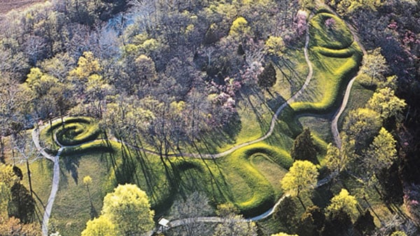
Hopewell Ceremonial Earthworks (30/01/2008). The Mound City Group is the only fully restored Hopewell earthwork complex. This earthwork comprises a 13-acre rectangular earth enclosure with at least 23 mounds. The height of the earth walls of the enclosure is about 3 to 4 feet, with an entrance or gateway on both the east and west sides. All the mounds are dome-shaped except for one that is elliptical. Early explorers described the largest mound of the group as 17.5 feet high and 90 feet in diameter. There are two additional mounds just outside the enclosure. All the walls and mounds have been reconstructed and are visible.
Native Americans constructed it over many centuries between A.D. 1 and 400. There is no evidence that people lived within this enclosure full-time. The Hopewell people did not even live in large villages. No more than three Hopewell homes have ever been discovered in one place. The complex required complicated engineering, likely the gathering place of people who wanted to form a community for religious and social reasons, and many essential ceremonies were conducted here. It functioned as a regionally significant cemetery and ceremonial site, not for ordinary people, but for the most important people in their culture.
The first step in mound-building was constructing a large ceremonial building of poles and bark with a plastered clay floor. Inside, fires burned in clay basins and ceremonies were conducted. When the ceremony was a funeral, the Hopewell cremated the body. The ashes were entombed on the building floor beneath a small mound of clay. About one hundred cremated remains were found at Mound City. At some point, the building would be purposely dismantled. Then, the mound construction probably began over many gatherings because the mounds consisted of alternating clay and sand layers.
Next to each burial, beautiful works of art were placed on the floor of the building. The exotic materials used by the artists indicate an extensive trade and travel network from the Gulf to Canada: shells from the Gulf, mica sheets from North Carolina, copper from Lake Superior and obsidian from Yellowstone. Mound 8 had 200 mostly broken effigy pipes skillfully carved from stone, showing detailed heads (hairstyles, headdresses and facial tattoos) and animals.
During World War I, the Mound City Group site was occupied by a military training center known as Camp Sherman. In the early 1920s, after Camp Sherman was razed, the Ohio Historical Society excavated the site and began reconstructing the Hopewell earthworks and mounds.


The mound contained no artifacts or burials that would help establish the mound’s age. The two leading theories are that the mound was built by either the Adena Culture (800 BC to 100 AD) around 320 BC or the Fort Ancient Culture (1000 to 1750 AD) around 1070 AD. From charcoal samples, it is conjectured that the mound was originally built between 381 BC and 44 BC, with a mean date of 321 BC. The more recent charcoal found in the 1990s is likely the result of a “repair” effort by Indians around 1070 AD.
The Serpent Mound’s coils are aligned with the two solstices and equinoxes yearly.
++++++++++++++++++++++++++++++++++++++++++++++++++++++++++++++
OHIO NORTH (Cleveland, Toledo, Youngstown, Canton, Akron)
I returned to Ohio after southern Michigan to travel along the south side of the Great Lakes.
Toledo (pop 275,000). It is a major Midwestern United States port city and a trade centre for the North Central United States; its port is the fifth busiest in the Great Lakes. The town was founded in 1833 on the west bank of the Maumee River. After the 1845 completion of the Miami and Erie Canal, Toledo grew quickly; it also benefited from its position on the railway line between New York City and Chicago. The first of many glass manufacturers arrived in the 1880s, eventually earning Toledo its nickname: “The Glass City.” It has since become a city with a distinctive and growing art community, auto assembly businesses, education, thriving healthcare, and well-supported local sports teams.
Lake Erie. At 241 miles long, 56 miles at its widest, with an average depth of 62 feet, and a 871-mile long shoreline, it is the fourth largest and smallest by volume of the Great Lakes. It is also the 11th largest in the world by surface area. It is the shallowest, warmest and most biologically active with the best walleye fishery in the world.
95% of its inflow is from the Detroit River (which connects it with the upstream Great Lakes. Downstream of the outlet is Niagara Falls.
Sandusky (pop 26,000). Situated in northern Ohio on the shores of Lake Erie, it is midway between Toledo to the west and Cleveland to the east. In 2011, Sandusky was ranked No. 1 by Forbes as the “Best Place to Live Cheaply” in the United States.
Sandusky is home to the Cedar Point amusement park, with one of the world’s largest collections of roller coasters, 17, and is widely regarded as one of the best amusement parks. The National Arbour Day Foundation has designated Sandusky as a Tree City USA.
Lorain Lighthouse was built in 1917 on Lake Erie by the United States Army Corps of Engineers. It was taken out of service in 1965 when an automated light tower replaced it on a nearby breakwater.
Marblehead Lighthouse is the oldest lighthouse in continuous operation on the United States side of the Great Lakes. It has guided sailors safely along the rocky shores of Marblehead Peninsula since 1822, and is an active aid to navigation. Originally a 50-foot (15 m) tower built of native limestone on the tip of the Marblehead Peninsula, the base of the tower is 25 feet in diameter, with walls 5 feet thick that narrow to 12 feet (3.7 m) at the top, with 2-foot-thick walls. Fifteen feet was added to the top, and a clock-like mechanism was installed to rotate the lantern, which required the lighthouse keeper to crank the weights every three hours through the night. It has been lit by whale oil, kerosene and finally an electric light in 1923,
The lighthouse is now part of the 9-acre Marblehead Lighthouse State Park.

CLEVELAND (pop 386,000, metro 2,057,009). The city is located on the southern shore of Lake Erie, across the U.S. maritime border with Canada and approximately 60 miles west of the Ohio-Pennsylvania state border. It was founded in 1796 near the mouth of the Cuyahoga River by General Moses Cleaveland. It became a manufacturing centre due to its location on the river and the lake shore, and being connected to numerous canals and railroad lines. Cleveland’s economy relies on diversified sectors such as manufacturing, financial services, healthcare, biomedicals, and higher education, and the city ranks 31st in the nation in terms of economic output, with a GDP of $134 billion in 2018.
The city’s major cultural institutions include the Cleveland Museum of Art, the Cleveland Orchestra, Playhouse Square, and the Rock and Roll Hall of Fame. Known as “The Forest City,” among many other nicknames, Cleveland is the center of the Cleveland Metroparks nature reserve system.
West Side Market. Cleveland’s oldest public market is home to 100 vendors offering meats, seafood, fruits, vegetables, baked goods, dairy, flowers, ready-to-eat foods, spices, and nuts. It is open Monday, Wednesday, Saturday, and Sunday.
++++++++++++++++++++++++++++++++++++++++++++++++++++++++++++++
KENTUCKY (Louisville, Lexington, Bowling Green)
Officially, the Commonwealth of Kentucky is the 37th most extensive and the 26th most populous of the 50 United States. The bluegrass region in the central part of the state houses the state’s capital, Frankfort, and its two largest cities, Louisville and Lexington, home to over 20% of the state’s population. Kentucky shares borders with Illinois, Indiana, and Ohio to the north, West Virginia and Virginia to the east, Tennessee to the south, and Missouri to the west.
Kentucky is known as the “Bluegrass State”, a nickname based on Kentucky bluegrass, a species of grass found in many of its pastures. Kentucky is home to the world’s longest cave system, Mammoth Cave National Park, one of the most extraordinary lengths of navigable waterways and streams in the contiguous United States, and the two largest artificial lakes east of the Mississippi River.
In 1792, Kentucky became the 15th state admitted to the Union, splitting from Virginia.
Kentucky is known for horse racing, bourbon, moonshine, coal, “My Old Kentucky Home” historic state park, automobile manufacturing, tobacco, bluegrass music, college basketball, Kentucky Fried Chicken, and the Kentucky colonel.
LEXINGTON (pop 324,000 metropolitan 517,000)
Known as the “Horse Capital of the World,” it is the heart of the state’s Bluegrass region. Notable locations in the city include the Kentucky Horse Park, The Red Mile, Keeneland race courses, Rupp Arena, Transylvania University, the University of Kentucky, and Bluegrass Community and Technical College. Lexington ranks 10th among US cities in college education rate, with 39.5% of residents having at least a bachelor’s degree.
Lexington has one of the nation’s most stable economies. It is “a fortified economy, strong in manufacturing, technology, and entrepreneurial support, benefiting from a diverse, balanced business base.” In 2011, Lexington was ranked as the 4th-best city for “Businesses and Careers” by Forbes magazine, the 5th-best city for Young Professionals in 2008, and the 6th-best “Value City” in 2011 by Kiplinger.
The city’s largest employer, the University of Kentucky, employed 13,563 as of 2017. The university ranks as the 9th-largest economic company in Kentucky, with an annual budget of $1.4 billion.
LOUISVILLE (pop 771,000, metropolitan 1.3 million)
The largest city in the Commonwealth of Kentucky. Named after King Louis XVI of France, Louisville was founded in 1778, making it one of the oldest cities west of the Appalachians. With nearby Falls of the Ohio as the only central obstruction to river traffic between the upper Ohio River and the Gulf of Mexico, the settlement first grew as a portage site.
Today, the city is known as the home of legendary boxer Muhammad Ali, the Kentucky Derby, Kentucky Fried Chicken (KFC), the University of Louisville and its Cardinals, Louisville Slugger baseball bats, and three of Kentucky’s six Fortune 500 companies: Humana, Kindred Healthcare, and Yum! Brands. Muhammad Ali International Airport, Louisville’s primary commercial airport, hosts UPS’s worldwide hub.
The Brown Hotel is a historic 16-story hotel in downtown Louisville. It contains 294 rooms and over 24,000 ft² of meeting space. The hotel, which featured 600 rooms, ballrooms, shops, meeting rooms, and restaurants, opened in 1923 for $4 million. The hotel quickly became a central part of the growing downtown Louisville economy and the social lives of the locals.
The week of the Kentucky Derby was and still is the most successful week of every year. In 1971, after financial shortfalls, Brown closed, and it became the headquarters for the city school system. It was reopened as a Hilton Hotel in 1983 and in 1993 was restored to its former glory. The dividing wall in every other room was removed, doubling the size of each guest room and taking the hotel from 600 rooms to its present 293 guest rooms. The hotel was sold to its present owner, 1859 Historic Hotels LTD, based out of Galveston, Texas, in 2006.
400 West Market. In the NM “Modern Architecture Buildings” series, it is a 35-story, 549-foot (167 m) high skyscraper built for $100 million in 1991. Currently the tallest building in Kentucky, it is constructed of reinforced concrete, as opposed to the steel construction usual for buildings of its height. A distinctive feature of the building is the 80-foot (24 m) high Romanesque dome, which reflects the building’s original name of Capital Holding, which is illuminated from the interior at night.
There is a statue in the plaza of 400 West Market of Alysheba, winner of the 1987 Kentucky Derby and a 1993 U.S. Racing Hall of Fame inductee.

Big Four Bridge is a six-span former railroad truss bridge that crosses the Ohio River, connecting Louisville, Kentucky, and Jeffersonville, Indiana. It was completed in 1895, updated in 1929, taken out of rail service in 1968, and converted to bicycle and pedestrian use in 2014. The longest single span is 547 feet (167 m), with the entire bridge spanning 2,525 feet (770 m). It took its name from the defunct Cleveland, Cincinnati, Chicago and St. Louis Railway, which was nicknamed the “Big Four Railroad”.
Access to the Big Four Bridge is limited to pedestrian and bicycle use, with a pedestrian ramp on the Kentucky side. The deck was replaced and connected to the spiral ramp, which was completed in Waterfront Park.

++++++++++++++++++++++++++++++++++++++++++++++++++++++++++++++
INDIANA (Indianapolis, Evansville, Fort Wayne)
In the Midwestern and Great Lakes regions, Indiana is the 38th-largest by area and the 17th-most populous of the 50 United States. Its capital and largest city is Indianapolis. Indiana was admitted to the United States as the 19th U.S. state in 1816. Indiana borders Lake Michigan to the northwest, Michigan to the north, Ohio to the east, Kentucky to the south and southeast, and Illinois to the west.
Before becoming a territory, various indigenous peoples and Native Americans inhabited Indiana for thousands of years. Since its founding as a territory, settlement patterns in Indiana have reflected regional cultural segmentation present in the Eastern United States; the state’s northernmost tier was settled primarily by people from New England and New York, Central Indiana by migrants from the Mid-Atlantic states and adjacent Ohio, and Southern Indiana by settlers from the Southern states, particularly Kentucky and Tennessee.
Indiana has a diverse economy with a gross state product of $359.12 billion in 2017. It has several metropolitan areas with populations greater than 100,000 and a number of smaller industrial cities and towns. Indiana is home to professional sports teams, including the NFL’s Indianapolis Colts and the NBA’s Indiana Pacers, and hosts several notable athletic events, including the Indianapolis 500.
With a choice of Wi-Fi sources, I parked at a large gas station in Indiana just across the border from Louisville, Kentucky, for 36 hours, playing bridge, reading, and taking some time off. Then it was a long detour west through southern Indiana to Santa Claus (Bizzarium is my favourite mini-series), cross-country to Indianapolis, and west through Illinois West/South to Springfield.
Santa Claus (pop 2,481). In the NM “Bizzarium” series, this town is in the southwestern part of the state between Interstate 64 and the Ohio River. The city was established in 1854 and is known as Santa Fe (pronounced “fee”). In 1856, when the city was working to establish a post office, the Post Office Department refused their first application as there was already a Santa Fe, Indiana, established with the Post Office Department. Several town meetings were held, during which the name Santa Claus was selected.
The town has the world’s only post office to bear the name of the eponymous Christmas figure. Because of this popular name, the post office receives thousands of letters to Santa worldwide each year. A group of volunteers known as Santa’s Elves ensures each child gets a reply from Santa Claus; this tradition has existed since at least 1914. Every year, the post office also creates a special Christmas hand-cancellation pictorial postmark for December, attracting mail worldwide.
Most Santa Claus residents live within the gated community of Christmas Lake Village, which Bill Koch developed in the late 1960s. It comprises 2,500 acres (10 km2) and is designed around three lakes: Christmas Lake, Lake Holly, and Lake Noel. The street names in Christmas Lake Village are all named after the Christmas season. Many residents also live in Holiday Village, a subdivision on the north side of town.
Santa Claus has numerous themed attractions, including Santa’s Candy Castle, Santa Claus Museum, Holiday World & Splashin’ Safari, Frosty’s Fun Center, Christmas Lake Golf Course, and Santa’s Stables. It is also home to Santa’s Lodge and Lake Rudolph Campground & RV Resort.
INDIANAPOLIS(pop 877,000, metropolitan 2.05 million)
Often shortened to Indy, it is the state capital and most populous city of Indiana and the 17th most populous city in the U.S.
Indigenous peoples inhabited the area dating to approximately 2000 BC. In 1818, the Delaware relinquished their tribal lands in the Treaty of St. Mary’s. In 1821, Indianapolis was founded as a planned city for the new seat of Indiana’s state government. The town was platted on a 1-square-mile (2.6 km2) grid beside the White River. Completing the National and Michigan roads and the arrival of rail later solidified the city’s position as a manufacturing and transportation hub. Two of the city’s nicknames reflect its historical ties to transportation—the “Crossroads of America” and “Railroad City”.
Indianapolis anchors the 27th largest economic region in the U.S., based primarily on the sectors of finance and insurance, manufacturing, professional and business services, education and health care, government, and wholesale trade. The city has notable niche markets in amateur sports and auto racing. The Fortune 500 companies of Anthem, Eli Lilly and Company, and Simon Property Group are headquartered in Indianapolis. The city is best known for annually hosting the world’s largest single-day sporting event, the Indianapolis 500.
Indianapolis is home to two major league sports clubs, the Indiana Pacers of the National Basketball Association (NBA) and the Indianapolis Colts of the National Football League (NFL). It is home to several educational institutions, such as the University of Indianapolis, Butler University, Marian University, and Indiana University – Purdue University Indianapolis (IUPUI). The city’s robust philanthropic community has supported several cultural assets, including the world’s largest children’s museum, one of the nation’s largest privately funded zoos, historic buildings and sites, and public art. The city is home to the largest collection of monuments dedicated to veterans and war casualties in the U.S. outside of Washington, D.C.
