
I am continuing my trip through the Midwest of the USA. All museums are closed, and I continue to get new Nomad Mania Regions and add to the few series still open. It has been cold—-8 on one night. A storm blew through, leaving a skiff of snow.
NEBRASKA
Nebraska lies both in the Great Plains and in the Midwestern United States. South Dakota borders it to the north; Iowa to the east; Missouri to the southeast, across the Missouri River; Kansas to the south; Colorado to the southwest; and Wyoming to the west. It is the only triply landlocked U.S. state.
Nebraska’s area is just over 77,220 square miles (200,000 km2), and its population is almost 1.9 million. Its capital is Lincoln, and its largest city is Omaha, on the Missouri River.
Indigenous peoples, including Omaha, Missouria, Ponca, Pawnee, Otoe, and various branches of the Lakota (Sioux) tribes, lived in the region for thousands of years before European exploration. The state is crossed by many historic trails, including that of the Lewis and Clark Expedition.
Nebraska comprises two major land regions: the Dissected Till Plains and the Great Plains. The Dissected Till Plains region consists of gently rolling hills and contains the state’s largest cities, Omaha and Lincoln. The Great Plains region, occupying most of western Nebraska, is characterized by treeless prairie, suitable for cattle-grazing.
Nebraska has two major climatic zones. The eastern half of the state has a humid continental climate, a unique warmer subtype considered “warm-temperate” exists near the southern plains, like Kansas and Oklahoma, which have a predominantly humid subtropical climate. The western half of the state has a primarily semi-arid climate. The state has wide variations between winter and summer temperatures, variations that decrease moving south within the state. Violent thunderstorms and tornadoes occur primarily during spring and summer and sometimes in autumn. Chinook wind tends to warm the state significantly in the winter and early spring.
Lincoln (pop 288,000) is the capital city of Nebraska. The city was founded in 1856 on the wild salt marshes and was renamed after President Abraham Lincoln. It became Nebraska’s state capital in 1869. The Bertram G. Goodhue-designed state capitol building was completed in 1932 and is the second-tallest capitol in the United States. As the city is the state of Nebraska’s government seat, the state and the United States government are major employers. The University of Nebraska was founded in Lincoln in 1869. The university is the largest in Nebraska, with 26,079 students enrolled, and is the city’s third-largest employer.
Designated as a refugee-friendly city by the U.S. Department of State in the 1970s, the city was the twelfth-largest resettlement site per capita in the United States by 2000. Refugee Vietnamese, Karen (Burmese ethnic minority), Sudanese and Yazidi (Iraqi ethnic minority) people, as well as other refugees from Iraq and the Middle East, have been resettled in the city. During the 2018–19 school year, Lincoln Public Schools supported approximately 3,000 students from 150 countries, who spoke 125 languages.
OMAHA (pop 466,000, metropolitan 1.3 million)
Omaha is the largest city in Nebraska on the Missouri River, about 10 miles (15 km) north of the mouth of the Platte River.
Omaha was founded in 1845 by speculators from neighbouring Council Bluffs, Iowa, along the Missouri River, and a crossing called Lone Tree Ferry earned the city its nickname, the “Gateway to the West”. Omaha introduced this new West to the world in 1898, when it hosted the World’s Fair. During the 19th century, Omaha’s central location in the United States spurred the city to become an important national transportation hub. Throughout the rest of the 19th century, the transportation and jobbing sectors, along with their railroads and breweries, were important in the city. In the 20th century, the Omaha Stockyards, once the world’s largest, and its meatpacking plants gained international prominence.
Today, Omaha is the home to the headquarters of four Fortune 500 companies: mega-conglomerate Berkshire Hathaway; one of the world’s largest construction companies, Kiewit Corporation; insurance and financial firm Mutual of Omaha; and the United States’ largest railroad operator, Union Pacific Corporation. Berkshire Hathaway is headed by local investor Warren Buffett, one of the wealthiest people in the world.
Omaha is also the home to five Fortune 1000 headquarters: Green Plains Renewable Energy, TD Ameritrade, Valmont Industries, Werner Enterprises, and West Corporation. Also headquartered in Omaha are the following: First National Bank of Omaha, the largest privately held bank in the United States; three of the nation’s ten largest architecture/engineering firms (DLR Group, HDR, Inc., and Leo A Daly; and the Gallup Organization, of Gallup Poll fame, and its riverfront Gallup University.
Notable modern Omaha inventions include the following: the “pink hair curler” created at Omaha’s Tip Top Products; Butter Brickle Ice Cream, and the Reuben sandwich, conceived by a chef at the then–Blackstone Hotel on 36th and Farnam Streets; cake mix, developed by Duncan Hines, then a division of Omaha’s Nebraska Consolidated Mills, the forerunner to today’s ConAgra Foods; center-pivot irrigation by the Omaha company now known as Valmont Corporation; Raisin Bran, developed by Omaha’s Skinner Macaroni Co.; the first ski lift in the U.S., in 1936, by Omaha’s Union Pacific Corp., the Top 40 radio format, pioneered by Todd Storz, scion of Omaha’s Storz Brewing Co. and head of Storz Broadcasting, and first used in the U.S. at Omaha’s KOWH Radio; and the TV dinner, developed by Omaha’s Carl A. Swanson.
Bob Kerrey Pedestrian Bridge. This 3,000-foot (910 m) footbridge across the Missouri River connects Council Bluffs, Iowa, and Omaha, Nebraska. It opened in 2008. The bridge is named after former Nebraska Senator Bob Kerrey, who secured $18 million of federal funding for the bridge in 2000.
The bridge is a cable-stayed design costing $22 million. It includes two 200-foot (61 m) towers and a clearance of 52 feet (16 m) above the river. The bridge lights include programmable controls that can display multiple colours in the large lights at the top of the towers and alter the brightness and timing of the lights that run the entire length of the bridge.

I visited an old classmate (went to school with from grade 8 to the end of Medical school. Her husband is the head of pediatric cardiac surgery in Omaha.
++++++++++++++++++++++++++++++++++++++++++++++++++++++++++++++
IOWA
Iowa is in the Midwestern US, bordered by the Mississippi River to the east and the Missouri River and Big Sioux River to the west. It is bordered by six states: Wisconsin to the northeast, Illinois to the east and southeast, Missouri to the south, Nebraska to the west, South Dakota to the northwest, and Minnesota to the north.
Iowa has the 26th-most extensive and the 30th-most populous of the 50 U.S. states. Des Moines is the state’s capital, most populous city, and largest metropolitan area. A portion of the larger Omaha, Nebraska, metro area extends into three counties of southwest Iowa. Iowa has been listed as one of the safest states to live in.
In colonial times, Iowa was a part of French Louisiana and Spanish Louisiana; its state flag is patterned after the flag of France. After the Louisiana Purchase, people laid the foundation for an agriculture-based economy in the heart of the Corn Belt.
In the latter half of the 20th century, Iowa’s agricultural economy transitioned to a diversified economy of advanced manufacturing, processing, financial services, information technology, biotechnology, and green energy production.
Driving through south Iowa reminded me of the Jutland part of Denmark – low rolling hills with trees and fields (most here planted in corn.
DES MOINES (pop 217,000, metropolitan 656,000)
Des Moines is the capital and most populous city in Iowa. It was incorporated in 1851 and named after the Des Moines River, which likely was adapted from the early French name Rivière des Moines, meaning “River of the Monks.”
Des Moines is a major centre of the US insurance industry and has a sizeable financial services and publishing business base. The city was credited as the “number one spot for U.S. insurance companies” in a Business Wire article and named the third-largest “insurance capital” of the world. The city is the headquarters for the Principal Financial Group, the Meredith Corporation, Ruan Transportation, TMC Transportation, EMC Insurance Companies, and Wellmark Blue Cross Blue Shield. Other major corporations such as Wells Fargo, Voya Financial, Nationwide Mutual Insurance Company, ACE Limited, Marsh, Monsanto, and DuPont Pioneer have significant operations in or near the metropolitan area. In recent years, Microsoft, Hewlett-Packard, and Facebook have built data-processing and logistical facilities in the Des Moines area. Forbes ranked Des Moines as the “Best Place for Business” in 2010 and 2013. In 2014, NBC ranked Des Moines as the “Wealthiest City in America” according to its criteria.
Des Moines is an important city in U.S. presidential politics; as the state’s capital, it is the site of the first caucuses of the presidential primary cycle. Many presidential candidates set up campaign headquarters in Des Moines. A 2007 article in The New York Times said, “If you have any desire to witness presidential candidates in the most close-up and intimate of settings, there is arguably no better place to go than Des Moines.”
Greater Des Moines Botanical Garden. Dating from 1979, the conservatory (dome has 665 plexiglass panels) has over a 1,200 different taxa from around the world, a new rose garden, entrance garden, nearly 0.5-acre water garden, maple allée, belvedere overlooking the Des Moines River, conifer and gravel garden, a hillside garden, and an annual and bulb parterre. The gardens feature rich annual colour designs conceived around artistic concepts inspired by music, history, art and pop culture, utilizing plants as the ingredients for exhibitions.
From 1986 until the mid-2000s, the Botanical Center was a Do-It-Yourself venue for the Des Moines Underground, Punk, and Hardcore Music scene. Countless national touring acts such as Henry Rollins, Scream, Saint Vitus, and regional and local bands played shows for all ages in the rental halls. These bands and their fans often had no other venue in the area, so the Botanical Center provided a much-needed space for the music scene.
Iowa Women of Achievement Bridge. A focal point of The Principal Riverwalk in Des Moines, this iconic bridge spans the Des Moines River, linking the east and west sides of the city at the northern edge of the riverwalk loop. This single-arch pedestrian bridge opened on June 28, 2010. It features two paths crossing the Des Moines River, one for cyclists and one for pedestrians, with the walkway over the middle of the river having a glass floor. The 434-foot-long bridge is part of a recently completed $70 million Riverwalk project, rejuvenating the city’s downtown area. A large central arch supports the cable-stayed bridge.
Beginning in 2013, notable women from Iowa’s history are honoured at this bridge each year. Local citizens provide the nominations, which are then reviewed by a committee that selects the recipients. Selections include women who have made a positive impact on the lives of others, achieved extraordinary accomplishments, inspired future generations, and been agents of change for the betterment of the state of Iowa, our nation, or the world.
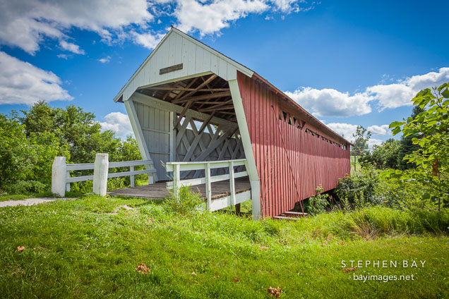
COVERED BRIDGES of MADISON COUNTY
Madison County originally boasted 19 covered bridges, but just six remain today, five of which are listed on the National Register of Historic Places. All are now pedestrian-only bridges. The bridges were covered by the County Board of Supervisors’ order to help preserve the large flooring timbers, which were more expensive to replace than the lumber used to cover the sides and roof. Usually, the bridges were named after the residents who lived closest to them.
The covered bridges are open to the public, and travellers can use a detailed map to self-guide a tour of the structures. Two bridges are accessible by pavement only—the Imes Bridge in St. Charles and the Cutler-Donahoe Bridge at City Park in Winterset. Cedar Bridge (which is currently being rebuilt and should be reopened by fall) is accessible via Cedar Bridge Road, which is mostly paved south of the bridge. You would only be on gravel for a couple of hundred feet.
The final three are on gravel/dirt roads – the Roseman, the Hogback and the Holliwell. Holliwell Bridge is on 1.9 miles of gravel after turning right onto Norwood Ave from E. Court Ave. If you access Hogback Bridge from 195th Street, then Hogback Bridge Road, it’s just over 2 miles of gravel. The Roseman is the furthest on gravel – 4.3 miles if you turn onto Roseman Bridge Road from I-92 to Elderberry. However, if you want to drive on less gravel, keep on I-92 to Elmwood Ave, which is only 2.2 miles of gravel.
Imes Covered Bridge. The oldest of the remaining covered bridges, Imes, was built in 1870 and is 81 feet in length. It was originally located over the Middle River west of Patterson. In 1887, it was moved to a spot over Clinton Creek southwest of Hanley. In 1977, it was moved again to its present location over a natural ravine just east of St. Charles, about 35 miles south of Des Moines. It was renovated in 1997 for $31,807.
Cedar Covered Bridge. Built in 1883, Cedar Bridge was 76 feet long and was the last bridge open to vehicles. It was built over Cedar Creek north of Winterset on US Highway 169. It was moved to its present location over the same creek in 1921. In Robert James Waller’s novel, The Bridges of Madison County, Cedar Bridge is where Francesca Johnson meets Robert Kincaid to help him take photographs. Cedar is also the bridge on the novel’s cover. The bridge was renovated in 1998 for $128,073. After being nearly destroyed by arson, Cedar Bridge was rebuilt and reopened to the public on Covered Bridge Festival weekend in 2019.
Cutler-Donahue Covered Bridge. Built in 1870, it is 79 feet long and features a pitched roof. Originally located over the North River near Bevington, it was moved to its present site in Winterset’s City Park in 1970. Cutler-Donahoe was renovated in 1997 for $35,538.

Hogback Covered Bridge. Built in 1884, it measures 97 feet and is in its original location in a valley north of Winterset. Hogback’s name comes from the limestone ridge that forms the valley’s west end. It was renovated in 1992 for $118,810.
Holliwell Covered Bridge. Built in 1880, Holliwell is the longest covered bridge, measuring 122 feet. It remains at its original site over the Middle River, southeast of Winterset. Holliwell was renovated in 1995 for $225,000. It is featured in the movie “The Bridges of Madison County.
Roseman Covered Bridge. Built in 1883, it is 107 feet long and sits in its original location. It was renovated in 1992 for $152,515. In Robert James Waller’s novel, The Bridges of Madison County, and the movie of the same name, Roseman is the bridge that Robert Kincaid seeks when he stops at Francesca Johnson’s home for directions. It is also where Francesca leaves her note inviting him to dinner.
Also known as the “haunted” bridge, Roseman is where two sheriffs’ posse trapped a county jail escapee in 1892. The man rose straight through the bridge’s roof, uttering a wild cry, and disappeared. He was never found, and it was decided that anyone capable of such a feat must be innocent.
++++++++++++++++++++++++++++++++++++++++++++++++++++++++++++++
MISSOURI
In the Midwestern United States, Missouri is bordered by eight states (tied for the most with Tennessee): Iowa to the north, Illinois, Kentucky and Tennessee (via the Mississippi River) to the east, Arkansas to the south and Oklahoma, Kansas and Nebraska to the west. With more than six million residents, it is the 18th-most populous state in the country. The largest urban areas are St. Louis, Kansas City, Springfield and Columbia; the capital is Jefferson City. The state is the 21st-most extensive in area. In the south are the Ozarks, a forested highland that provides timber, minerals, and recreation. The Missouri River, after which the state is named, flows through the state’s center into the Mississippi River, which makes up Missouri’s eastern border.
Humans have inhabited the land now known as Missouri for at least 12,000 years. The Mississippian culture built cities and mounds before declining in the 14th century. When European explorers arrived in the 17th century, they encountered the Osage and Missouri nations. The French established Louisiana, a part of New France, founding Ste. Genevieve in 1735 and St. Louis in 1764. After a brief Spanish rule, the United States acquired the Louisiana Purchase in 1803. Americans from the Upland South, including enslaved African Americans, rushed into the new Missouri Territory. Missouri was admitted as a slave state as part of the Missouri Compromise. Many from Virginia, Kentucky and Tennessee settled in the Boonslick area of Mid-Missouri. Soon after, heavy German immigration formed the Missouri Rhineland.
Missouri played a central role in the United States’ westward expansion, as memorialized by the Gateway Arch. The Pony Express, Oregon Trail, Santa Fe Trail and California Trail all began in Missouri. Missouri’s role in the American Civil War was complex as a border state, and there were many conflicts within. After the war, Greater St. Louis and the Kansas City metropolitan area became centres of industrialization and business.
Missouri’s culture blends elements from the Midwestern and Southern United States. The musical styles of ragtime, Kansas City jazz and St. Louis blues developed in Missouri. The well-known Kansas City-style barbecue and lesser-known St. Louis-style barbecue can be found across the state and beyond. Missouri is also a major centre of beer brewing; Anheuser-Busch is the largest producer in the world. Missouri wine is produced in the Missouri Rhineland and Ozarks. Missouri’s alcohol laws are among the most permissive in the United States. Popular tourist destinations outside the state’s major cities include the Lake of the Ozarks, Table Rock Lake and Branson.
Well-known Missourians include Chuck Berry, Sheryl Crow, Walt Disney, Edwin Hubble, Nelly, Randy Orton, Brad Pitt, Harry S. Truman, and Mark Twain. Some of the largest companies based in the state include Cerner, Express Scripts, Monsanto, Emerson Electric, Edward Jones, H&R Block, Wells Fargo Advisors, and O’Reilly Auto Parts. Universities in Missouri include the University of Missouri and the top-ranked Washington University in St. Louis. Missouri has been called the “Mother of the West” and the “Cave State”, but its most famous nickname is the “Show Me State”.
KANSAS CITY/INDEPENDENCE (MO/KS)
Kansas City (abbreviated KC or KCMO) (pop 492,000) is the largest city in Missouri by population and area. It is the 38th most populous city in the United States. It is the most populated municipality and historic core city of the Kansas City metropolitan area, which straddles the Kansas–Missouri state line and has a CSA population of 2,487,053.
Kansas City was founded in the 1830s as a Missouri River port at its confluence with the Kansas River coming in from the west. On June 1, 1850, the town of Kansas was incorporated; shortly after, the establishment of the Kansas Territory came. Confusion between the two ensued, and the name Kansas City was assigned to distinguish them soon after.
The city comprises several neighbourhoods, including the River Market District in the north, the 18th and Vine District in the east, and the Country Club Plaza in the south. Kansas City is known for its long jazz music and culture tradition, especially theatre – it was the center of the Vaudevillian Orpheum circuit in the 1920s. It is also noted for its cuisine, distinctive Kansas City-style barbecue, and craft breweries.
Independence (pop 117,000, 2010) is the fifth-largest city in Missouri. Independence is a satellite city of Kansas City, Missouri, and is part of the Kansas City metropolitan area.
Independence is known as the “Queen City of the Trails” because it was a point of departure for the California, Oregon, and Santa Fe Trails. It was also the hometown of U.S. President Harry S. Truman; the Truman Presidential Library and Museum is in the city, and Truman and First Lady Bess Truman are buried here. The city is also sacred to many Latter-day Saints, with Joseph Smith’s 1831 Temple Lot located here, as well as the headquarters of several Latter-day Saint factions.
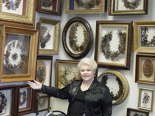
Leila’s Hair Museum, Independence. In the NM “Bizzarium” series, Liela Cohoon’s Hair Museum displays 400+ wreaths and more than 2,000 pieces of jewelry made out of human hair. Though turning hair into wreaths was a Victorian obsession, hair art dates back to the 1400s. Some of the displays in Cohoon’s collection come from as far back as the 17th century. In an age before photography, collecting hair was a way of capturing the essence of a person at a point in time, and keeping the memory of a deceased loved one near. “That is the only part of that human body that’s still here,” says Cohoon.


Kansas City Library. After remodelling the former First National Bank, the Central Library moved into this building in 2004.
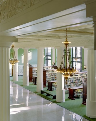
The restored 1906 historic bank lobby is one of the most magnificent spaces.
The Grand Reading Room on the third floor has a distinctive, 34-foot ceiling with a skylight.
The old bank Vault, part of the 1925 bank addition, is one of the building’s most distinctive features. It has walls of steel and reinforced concrete and a 35-ton steel door.
The NM “Modern Architecture Buildings” has a marble façade with six grand columns and decorative brass doors.
Kauffman Center for the Performing Arts. Located in the NM “Modern Architecture Buildings,” this performing arts center in downtown Kansas City, Missouri, was a major part of the ongoing redevelopment of downtown Kansas City. No taxpayer funds went into its construction.
The center’s exterior consists of two symmetrical half shells of vertical, concentric arches that open toward the south. Each shell houses one acoustically independent performance venue, the Muriel Kauffman Theatre and Helzberg Hall, although the backstage area is shared. The south façade of the Center is made entirely of glass. The lobby is an expansive glazed porch with a glass tent-like structure. For those on the outside, the Kauffman Center becomes like a terrarium, revealing the thousands of attendees backlit against the white interior.
It is the home to the Kansas City Symphony, the Lyric Opera of Kansas City, and the Kansas City Ballet. The Kauffman Center houses two unique performance venues:


Parkville (pop 5,600). In the NM “small towns series, it is a part of the Kansas City Metropolitan Area about 10 km NW of Kansas City. Parkville is known for its antique shops, art galleries, and historic downtown. The city is home to Park University, English Landing Park and National Golf Club of Kansas City and has a private reservoir with houses around it named Riss Lake.
++++++++++++++++++++++++++++++++++++++++++++++++++++++++++++++
KANSAS
Kansas is in the Midwestern United States. Its capital is Topeka , and its largest city is Wichita. KNebraska borders Kansas o the north; Missouri on the east; Oklahoma on the south; and Colorado on the west. Kansas is named after the Kansas River, which ias named ater the Kansa Native Americans who lived along its banks. For thousands of years, it was home to numerous and diverse Native American tribes. Tribes in the eastern part of the state generally lived in villages along the river valleys. Tribes in the western part of the state were semi-nomadic and hunted large herds of bison.
Americans first settled Kansas in 1827 with the establishment of Fort Leavenworth. The settlement accelerated in the 1850s, amid political wars over the slavery debate. When it was officially opened to settlement by the U.S. government in 1854 with the Kansas–Nebraska Act, abolitionist Free-Staters from New England and pro-slavery settlers from neighbouring Missouri rushed to the territory to determine whether Kansas would become a free state or a slave state. Thus, the area was a hotbed of violence and chaos in its early days as these forces collided, and it was known as Bleeding Kansas. The abolitionists prevailed, and on January 29, 1861, Kansas entered the Union as a free state, hence the unofficial nickname “The Free State”.
By 2015, Kansas was one of the most productive agricultural states, producing high wheat, corn, sorghum, and soybean yields.[21] Kansas, which has an area of 82,278 square miles (213,100 km²), is the 15th-largest state by area and is the 34th most populous of the 50 states, with a population of 2,913,314. Residents of Kansas are called Kansans. Mount Sunflower is Kansas’s highest point at 4,039 feet (1,231 meters).
Lawrence (pop 98,000). About 42 miles west of Kansas City, it is the sixth-largest city in Kansas. Astride Interstate 70, Lawrence is a college town home to the University of Kansas and Haskell Indian Nations University.
Lawrence was founded by the New England Emigrant Aid Company (NEEAC) and named for Amos Adams Lawrence, a Republican abolitionist originally from Massachusetts who offered financial aid and support for the settlement.[12] Lawrence was central to the “Bleeding Kansas” period (1854–61) and the site of the Wakarusa War (1855) and the Sacking of Lawrence (1856). During the American Civil War, it was also the site of the Lawrence massacre (1863).
Lawrence began as a center of free-state politics. Its economy diversified into many industries, including agriculture, manufacturing, and education, beginning with the founding of the University of Kansas in 1865 and Haskell Indian Nations University in 1884.
Stull Cemetery, Stull. In the NM “Dark Side” series, Stull is an unincorporated community in Douglas County, Kansas. Founded in 1857, the settlement was initially known as Deer Creek until it was renamed after its only postmaster, Sylvester Stull. As of 2018, only a handful of structures remain in the area.
Since the 1970s, the town has become infamous due to an apocryphal legend that claims demonic forces possess the nearby Stull Cemetery. Despite its falsity, this legend has also become a facet of American popular culture and has been referenced in numerous forms of media. This legend has also led to controversies with current residents of Stull.
Legend of Stull Cemetery. The tiny town of Stull is far removed from the horrible story of The Exorcist or the bizarre black masses recently discovered in Los Angeles, and tucked away on a rough county road between Topeka and Lawrence. Unlike the town of Sleepy Hollow, described by Washington Irving in his famous tale, Stull is one of those towns motorists can miss by blinking. Stull and Sleepy Hollow have another thing in common. Legends of diabolical, supernatural happenings haunt both.
The Stull Cemetery has gained an ominous reputation due to urban legends involving Satan, the occult, and a purported “gateway to Hell”. The rumours about the cemetery were popularized by a November 1974 issue of The University Daily Kansan (the University of Kansas student newspaper), which claimed that the Devil appeared in Stull twice a year: once on Halloween and once on the spring equinox. People soon said that the cemetery was the location of one of the seven gates to Hell and that the nearby Evangelical Emmanuel Church ruin was “possessed” by the Devil. Others claimed (erroneously) that the legend was engendered by the killing of Stull’s mayor back in the 1850s (of note, Stull was never organized as a town, so it never had a mayor). It is also said that during a trip to Colorado in the 1990s, the Pope redirected the flight path of his private plane to avoid flying over the unholy ground of Stull (although there is no evidence that this happened). Most academics, historians, and residents agree that the legend has no basis in historical fact and was created and spread by students.
In the years that followed the publication of the University Daily Kansan article, the legend persuaded thrill seekers to visit the cemetery, and they would claim that weird and creepy events, such as noises and memory lapses, happened to them, leading to further speculation that witches and the devil haunted the town. It became popular for young folks (especially high school and college students from Lawrence or Topeka) to journey to the cemetery on Halloween or the equinox to “see the Devil”. Many would jump fences or otherwise sneak their way onto the property. Over the decades, as the number of people making excursions to the cemetery grew, the graveyard started to deteriorate; vandals exacerbated this. To combat this, the county’s sheriff’s office patrols the area around the cemetery, especially on Halloween, and will arrest people for trespassing. Those caught inside the cemetery after it is closed could face a maximum fine of $1,000 and up to six months in jail.
Despite its dubious origins, the legend of Stull Cemetery has been referenced numerous times in popular culture. The band Urge Overkill released the Stull EP in 1992, which features the church and a tombstone from the cemetery on the cover. It has been argued that the British band The Cure cancelled their show in Kansas because of Stull’s cemetery, although this is false. Films whose plot is based on the legends include Turbulence 3: Heavy Metal (2001), Nothing Left to Fear (2013), and the unreleased film Sin-Jin Smyth. The cemetery is also the site of the final confrontation between Lucifer and Michael in “Swan Song”, the season five finale of Supernatural and the History Channel documentary. In-universe, Sam and Dean Winchester (the series’ protagonists) are from Lawrence; in a 2006 interview, Eric Kripke (the creator of Supernatural) revealed that he decided to have the two brothers be from Lawrence because of its closeness to Stull. In an interview with Complex Magazine, pop star Ariana Grande talked about her unsuccessful attempt to visit Stull and stated that demons attacked her.
Topeka (128,000, metropolitan 234,000). The capital city of Kansas is along the Kansas River. Topeka is a Kansa-Osage sentence that means “place where we dug potatoes”, or “a good place to dig potatoes”. The city, laid out in 1854, was one of the Free-State towns founded by Eastern antislavery men immediately after the passage of the Kansas–Nebraska Bill.
The city is well known for the landmark U.S. Supreme Court case Brown v. Board of Education of Topeka, which overturned Plessy v. Ferguson and declared racial segregation in public schools unconstitutional. The U.S. Navy has named three ships USS Topeka after the city.
Cottonwood Falls. In the NM “small towns” series, it was established in 1859. The courthouse, built in 1877, is a French Renaissance native limestone building. The Santa Fe Railway bypassed the town in 1871 at Strong City. This resulted in interurban transport starting in 1887 with a horsecar service and 1918 a car service that ceased in 1919. It is a cute, tiny village with a typical US small town downtown, but with a brick street downtown.
WICHITA (pop 390,000, metropolitan 645,000)
Wichita is the largest city in Kansas. Located in south-central Kansas on the Arkansas River, it began as a trading post on the Chisholm Trail in the 1860s and was incorporated as a city in 1870. It became a destination for cattle drives travelling north from Texas to Kansas railroads, earning it the nickname “Cowtown.”
In the 1920s and 1930s, business people and aeronautical engineers established aircraft manufacturing companies in Wichita, including Beechcraft, Cessna, and Stearman Aircraft. The city became an aircraft production hub called “The Air Capital of the World.” Textron Aviation, Learjet, Airbus, and Spirit AeroSystems continue to operate design and manufacturing facilities in Wichita, and the city remains a major center of the American aircraft industry. Wichita is also home to McConnell Air Force Base, and Wichita Dwight D. Eisenhower National Airport, the largest airport in Kansas.
As an industrial hub, Wichita is a regional cultural, media, and trade center. It hosts several universities, large museums, theatres, parks, and entertainment venues, notably Intrust Bank Arena and Century II Performing Arts & Convention Center. The city’s Old Cowtown Museum maintains historical artifacts and exhibits on the city’s early history. Wichita State University is the third-largest post-secondary institution in the state.
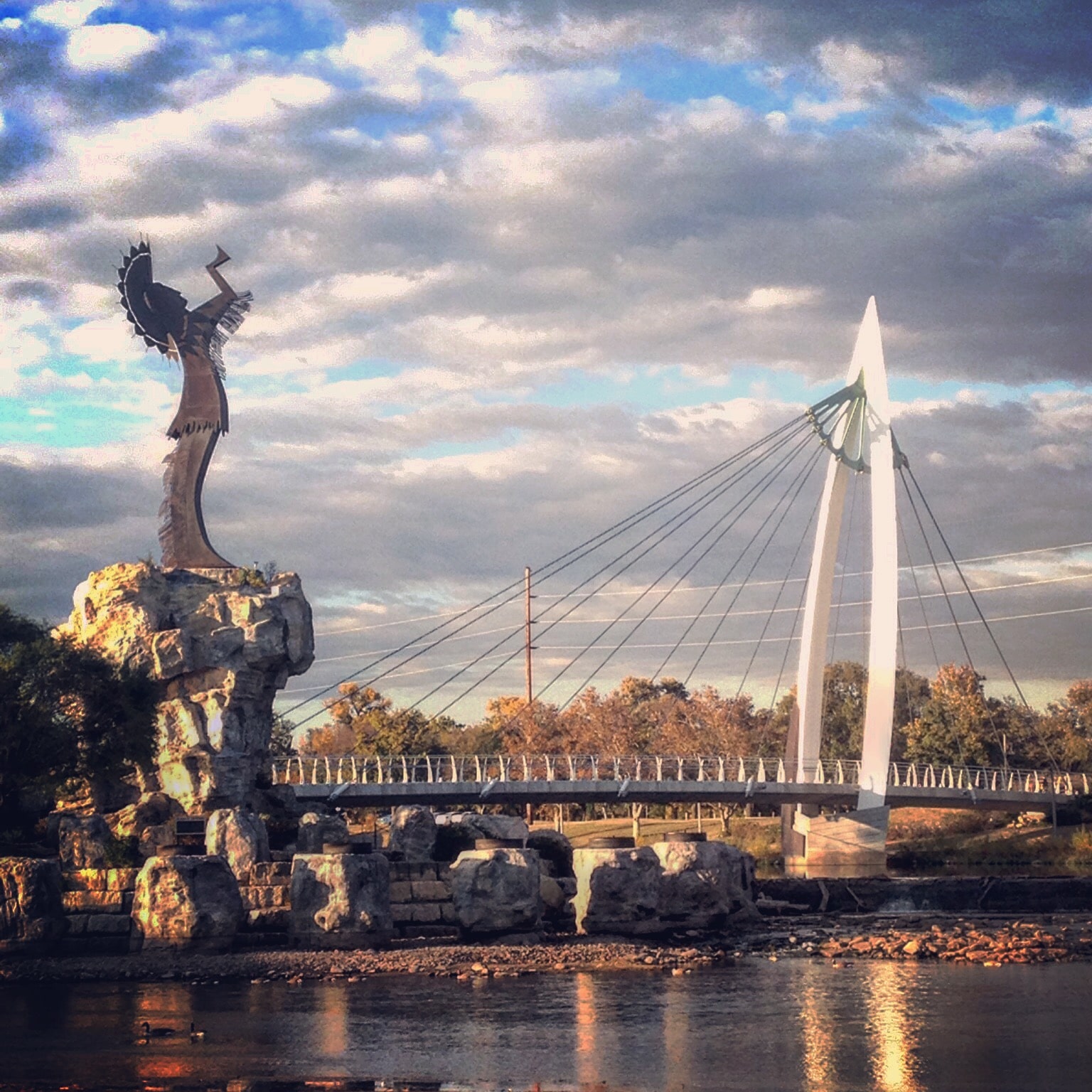
Keeper Of The Plains Bridge. These are two cable-stayed pedestrian bridges crossing the Little and Big Arkansas Rivers at the point where the two rivers meet. On the tiny peninsula in the centre, there is an excellent display on the Plains Indians from southern Canada to Mexico. One of the most iconic images in Wichita, A statue called Keeper of the Plains, stands at the confluence of the Big and Little Arkansas rivers. This 44-foot, 5-ton weathered steel sculpture was donated to Wichita by Native American artist Blackbear Bosin in 1974. It sits atop a 30-foot pedestal overlooking the city.
++++++++++++++++++++++++++++++++++++++++++++++++++++++++++++++
OKLAHOMA is in the South Central US, bordered by Texas on the south and west, Kansas on the north, Missouri on the northeast, Arkansas on the east, New Mexico on the west, and Colorado on the northwest. It is the 20th largest and the 28th-most populous of the 50 United States. Its residents are known as Oklahomans (or colloquially, “Okies”), and its capital and largest city is Oklahoma City.
The state’s name is derived from the Choctaw words okla and humma, meaning “red people”. It is also known informally by its nickname, “The Sooner State”, about the non-Native settlers who staked their claims on land before the official opening date of lands in the western Oklahoma Territory or before the Indian Appropriations Act of 1889,
With ancient mountain ranges, prairie, mesas, and eastern forests, most of Oklahoma lies in the Great Plains, Cross Timbers, and the U.S. Interior Highlands, all regions prone to severe weather. Oklahoma is on a confluence of three major American cultural regions and historically served as a route for cattle drives, a destination for Southern settlers, and a government-sanctioned territory for Native Americans. More than 25 Native American languages are spoken in Oklahoma.
Oklahoma, a major producer of natural gas, oil, and agricultural products, relies on an economic base of aviation, energy, telecommunications, and biotechnology. Oklahoma City and Tulsa are its primary economic anchors, and nearly two-thirds of Oklahomans live within their metropolitan statistical areas.
Edmond Cross at Life.Church, Edmond Campus. In the NM “Religious Monuments” series, it is visible for some distance in both directions on I-35; you’ll crest a hill to see a massive white cross looming over the highway.
Unlike other giant crosses in Groom, Texas, and Effingham, Illinois, this cross is not metal skin on a space frame. It comprises eight-inch-thick prestressed high-strength concrete, 138.5 feet high and 10 feet wide across the diagonals. It is a simple white cross with square components turned 90°. The cross sits on a large concrete base with crosses and doves.
It’s in the parking lot of the main campus of Life Church, a franchised Christian community, with multiple church locations sharing high-tech video via satellites.
OKLAHOMA CITY (pop 649,021, metropolitan area 1,469,124)
Often shortened to OKC, it is the capital and largest city in Oklahoma, the 27th largest city in the United States in terms of population.
Lying in the Great Plains region, Oklahoma City has one of the world’s largest livestock markets. Oil, natural gas, petroleum products, and related industries are the largest sectors of the local economy. The city is in the middle of an active oil field, and oil derricks dot the Capitol grounds. The federal government employs many workers at Tinker Air Force Base and the United States Department of Transportation’s Mike Monroney Aeronautical Center. Oklahoma City is on the I-35 Corridor, one of the primary travel corridors south into neighbouring Texas and Mexico and north towards Wichita and Kansas City.
The city was founded during the Land Run of 1889 and grew to a population of over 10,000 within hours of its founding. The city was the scene of the April 19, 1995, bombing of the Alfred P. Murrah Federal Building, in which 168 people died. It was the deadliest terror attack in the history of the United States until the attacks of September 11, 2001, and remains the deadliest act of domestic terrorism in U.S. history.
Since the time weather records have been kept, Oklahoma City has been struck by thirteen strong tornadoes. Since 2008, Oklahoma City has been home to the National Basketball Association (NBA)’s Oklahoma City Thunder, which plays its home games at the Chesapeake Energy Arena.
The Oklahoma City bombing was a domestic terrorist truck bombing on the Alfred P. Murrah Federal Building in Oklahoma City on April 19, 1995. Perpetrated by Timothy McVeigh and Terry Nichols, the bombing happened at 9:02 am and killed at least 168 people, injured more than 680 others, and destroyed one-third of the building. The blast destroyed or damaged 324 other buildings within a 16-block radius, shattered glass in 258 nearby buildings, and destroyed or burned 86 cars, causing an estimated $652 million worth of damage. Until the September 11, 2001, attacks, the Oklahoma City bombing was the deadliest terrorist attack in the history of the United States, and remains the deadliest incident of domestic terrorism in the country’s history.
Within 90 minutes of the explosion, McVeigh was stopped by Oklahoma Highway Patrolman Charlie Hanger for driving without a license plate and arrested for illegal weapons possession. Forensic evidence quickly linked McVeigh and Nichols to the attack; Nichols was arrested, and within days, both were charged. McVeigh, a veteran of the Gulf War and a U.S. militia movement sympathizer, had detonated a Ryder rental truck full of explosives parked in front of the building. His co-conspirator, Nichols, had assisted with the bomb’s preparation. Motivated by his dislike for the U.S. federal government and unhappy about its handling of the Ruby Ridge incident in 1992 and the Waco siege in 1993, McVeigh timed his attack to coincide with the second anniversary of the deadly fire that ended the siege at the Branch Davidian compound in Waco, Texas. The bombers were tried and convicted in 1997. McVeigh was executed by lethal injection on June 11, 2001, and Nichols was sentenced to life in prison in 2004.
Oklahoma City National Memorial and Museum. In the NM “The Dark Side” series, this was built in 2000 on the site of the Murrah Federal Building, commemorating the victims of the bombing at a total cost of $29.1 million; $10 million for the Outdoor Symbolic Memorial, $7 million for the Memorial Museum, $5 million for the Memorial Institute for the Prevention of Terrorism and the rest for other costs with more than $17 million in private donations.
The Outdoor Symbolic Memorial consists of: The Gates of Time: Monumental twin bronze gates frame the moment of destruction – 9:02 – and mark the formal entrances to the Outdoor Memorial. 9:01, found on the eastern gate, represents the last moments of peace, while its opposite on the western gate, 9:03, represents the first moments of recovery. Both time stamps are inscribed on the monument’s interior, facing each other and the Reflecting Pool. The outside of each gate bears this inscription:
We come here to remember those who were killed, those who survived and those who were changed forever. May all who leave here know the impact of violence. May this memorial offer comfort, strength, peace, hope and serenity.
Reflecting Pool: A thin layer of water flows over polished black granite, allowing visitors to see a mirror image of themselves in the water. Field of Empty Chairs: 168 empty chairs hand-crafted from glass, bronze, and stone represent those who lost their lives, with a name etched in the glass base of each. They sit on the site where the Murrah Building once stood. The chairs are arranged in nine rows to symbolize the nine floors of the building; each person’s chair is on the row (or the floor) on which the person worked or was located when the bomb went off. The chairs are also grouped according to the blast pattern, with the most chairs nearest the most heavily damaged portion of the building. The westernmost column of five chairs represents the five people who died but were not in the Murrah Building (two in the Water Resources Board building, one in the Athenian Building, one outside near the building, and one rescuer). The 19 smaller chairs represent the children killed in the bombing. Three unborn children died along with their mothers, and they are listed on their mothers’ chairs beneath their mothers’ names.
Survivors’ Wall: several panels of granite salvaged from the Murrah Building are inscribed with the names of more than 600 survivors from the building and the surrounding area, many of whom were injured in the blast.
Survivor Tree: An American elm on the north side of the Memorial that was heavily damaged by the bomb, but survived. Hundreds of seeds from the Survivor Tree are planted annually, and the resulting saplings are distributed each year on the anniversary of the bombing. Thousands of Survivor Trees are growing in public and private places all over the U.S.
The Memorial Fence: A 10-foot-tall chain link fence was installed around the area that is now the Reflecting Pool and the Field of Empty Chairs to protect the site from damage and visitors from injury. The Fence stood for more than four years, becoming notable as the place where visitors left stuffed animals, poems, keychains, and other items as tributes. During the construction of the Outdoor Memorial, 210 feet (64 m) of the Fence was moved to the west side of the Memorial. Visitors may still leave small items along and in the Fence; the mementos are periodically collected, cataloged, and stored.
Rescuers’ Orchard: A grove of Oklahoma redbuds (Oklahoma’s state tree), Amur Maple, Chinese Pistache, and Bosque Elm trees are planted on the lawn around the Survivor Tree.
Children’s Area: More than 5,000 hand-painted tiles, from all over the United States and Canada, were made by children and sent to Oklahoma City after the 1995 bombing. Most are stored in the Memorial’s Archives, and a sampling of tiles is on the wall in the Children’s Area. Chalkboards provide a place for children to draw and share their feelings.
Alfred P. Murrah Federal Building Plaza: An original part of the federal building, the plaza had a garden, seating areas, and a playground for the daycare center. Remembrance services are held every year on April 19, at the time of the explosion.
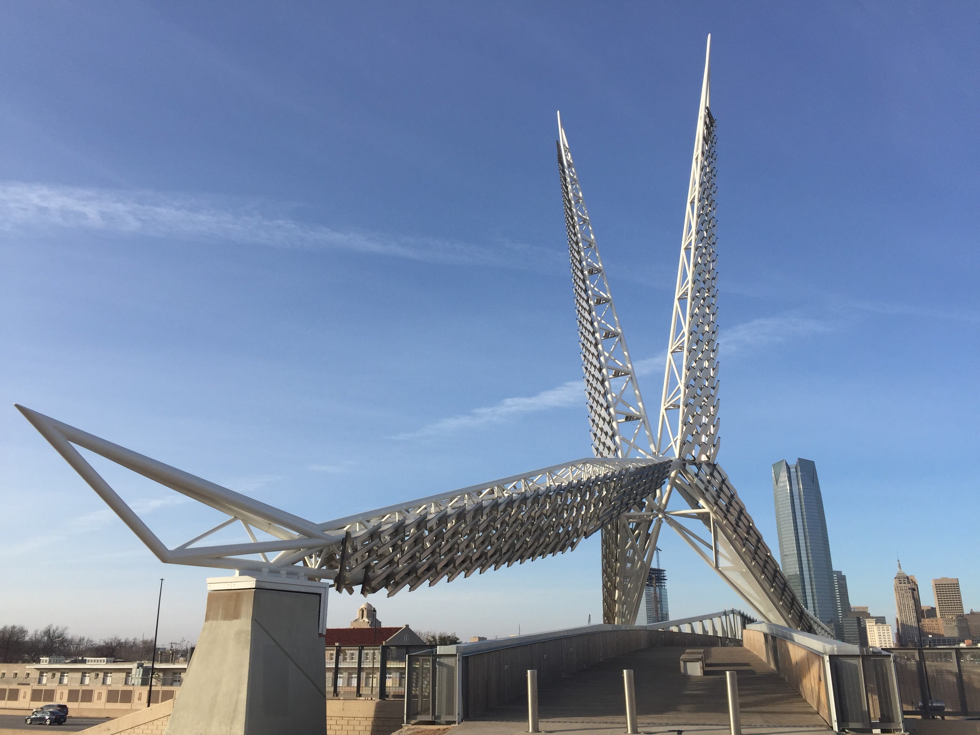
SkyDance Bridge is a pedestrian bridge and public artwork over Interstate I-40, built in 2011 for $12.8 million. It is inspired by the sky dance of the Scissor-tailed flycatcher, the Oklahoma state bird.
It is 380 feet long, 192 feet tall, and 20 feet wide, and it has a bird sculpture on the south side made of steel trusses. In 2020, a $840,000 project replaced the wood deck with a fibreglass deck. The bridge is a stunner to look at, especially at night. When the scissor-tailed flycatcher is courting, it performs a sky dance, including wild acrobatics and a reverse somersault! In the day, the bridge towers over cars as they drive underneath it. By night, it lights up with LED lights in many colours, welcoming visitors warmly to downtown.
In 2012, the structure was named one of the 50 best public art projects in the United States by the Americans for the Arts’ “Public Art Network Year in Review”.
Frank Lloyd Wright Buildings in Oklahoma. The Price Tower is a nineteen-story, 221-foot-high tower in Bartlesville, Oklahoma, built in 1956 to a design by Frank Lloyd Wright. It is the only realized skyscraper by Wright, and is one of only two vertically oriented Wright structures extant (the other is the S.C. Johnson Wax Research Tower in Racine, Wisconsin). Harold C. Price of the H. C. Price Company, a local oil pipeline and chemical firm, commissioned the Price Tower. It opened to the public in February 1956. Harold Price, Jr., is home in Bartlesville. Wright also designed a home in midtown Tulsa, the Richard Lloyd Jones house near 36th and Lewis. It is also called Westhope.
Norman (pop 124,000). Located 20 miles (32 km) south of downtown Oklahoma City, it is the third-largest city in Oklahoma.
Norman was settled during the Land Run of 1889, which opened the former Unassigned Lands of Indian Territory to American pioneer settlement. The city was named in honour of Abner Norman, the area’s initial land surveyor, and was formally incorporated in 1891. Economically, the city has prominent higher education and related research industries, as it is home to the University of Oklahoma, the largest university in the state, with nearly 32,000 students enrolled. The university is well known for its sporting events by teams under the nickname “Sooners” banner, with over 85,000 people routinely attending football games. The university is home to several museums, including the Fred Jones Jr. Museum of Art, which contains the most extensive collection of French Impressionist art ever given to an American university, and the Sam Noble Oklahoma Museum of Natural History.
The National Weather Center, located in Norman, houses a unique collection of university, state, federal, and private sector organizations that work together to improve the understanding of events related to the Earth’s atmosphere. Norman lies within Tornado Alley, where tornado activity is particularly frequent and intense. The Oklahoma City metropolitan area, including Norman, is the most tornado-prone in the world. The Storm Prediction Center (SPC), a National Oceanic and Atmospheric Administration (NOAA) branch, is located at the NWC. SPC forecasts severe storms and tornado outbreaks nationwide.
Paul’s Valley (pop 6,187 in 2010) was settled by and named for Smith Paul, a North Carolina native who married a Chickasaw woman and became a citizen of the Chickasaw Nation before the Civil War. The town economy is largely based on agriculture and oil production.
The area that eventually became the city of Pauls Valley was one of the earliest European-American settlements in what was then known as Indian Territory. Smith Paul, born in 1809 in North Carolina, discovered the fertile bottom land now known as Pauls Valley while a wagon train member travelling to California. Paul described the land as “a section where the bottom land was rich and blue stem grass grew so high that a man on horseback was almost hidden in its foliage.”
The Tri-Party Treaty of January 1, 1837, ceded this part of the State of Oklahoma to the Chickasaw Nation. When the Chickasaw people were relocated to Indian Territory that year, Smith Paul moved with them and married Ela-Teecha, a Chickasaw woman. In 1847, the Pauls established a plantation on the rich Garvin County bottom land, where Rush Creek joined the Washita River, which became known to locals as “Smith Paul’s Valley”. Mail to the Pauls was often addressed to “Smith Paul’s Large Farm”.” By 1871, the postal service was established in the area. However, the post office was designated “Paul’s Valley, Arkansas” because the Indian Territory was being administered out of Arkansas at the ime.
The Atchison, Topeka and Santa Fe Railway (a.k.a. Santa Fe Railway) shortened the name to “Paul’s Valley” when it built a track through the community in 1887, completing its connection between Kansas and the Gulf Coast. The railroad brought growth and prosperity to Smith Paul’s Valley. The first newspaper was published in 1887, a U.S. courthouse was built in 1895, the first white school in Indian Territory was established, and brick buildings were built downtown. In 1909, the streets were paved. Today, Pauls Valley has more brick streets—17,986 square yards (15,039 m2)—than any other town in the United States.
When the Santa Fe Railway discontinued its Lone Star route in 1979, the 1905 building was converted into a museum. In 1999, Amtrak began its Heartland Flyer service between Oklahoma City and Fort Worth, passing through Pauls Valley.
