
Niger (pronounced: nee-ZHAIR) is an arid, landlocked country of the Sahel. Niger is a former French colony that was granted independence in 1960. The land is mostly desert plains and dunes, with rolling savanna in the southeast with nothing much to see.
Capital: Niamey
Currency: West Africa Franc XOF CFA. 1US$=643; 1€=655 (xe.com (July 2022)
Population: 17.1 million
People. Hausa (Zarma and Songhai) are the largest ethnic groups in Niger.
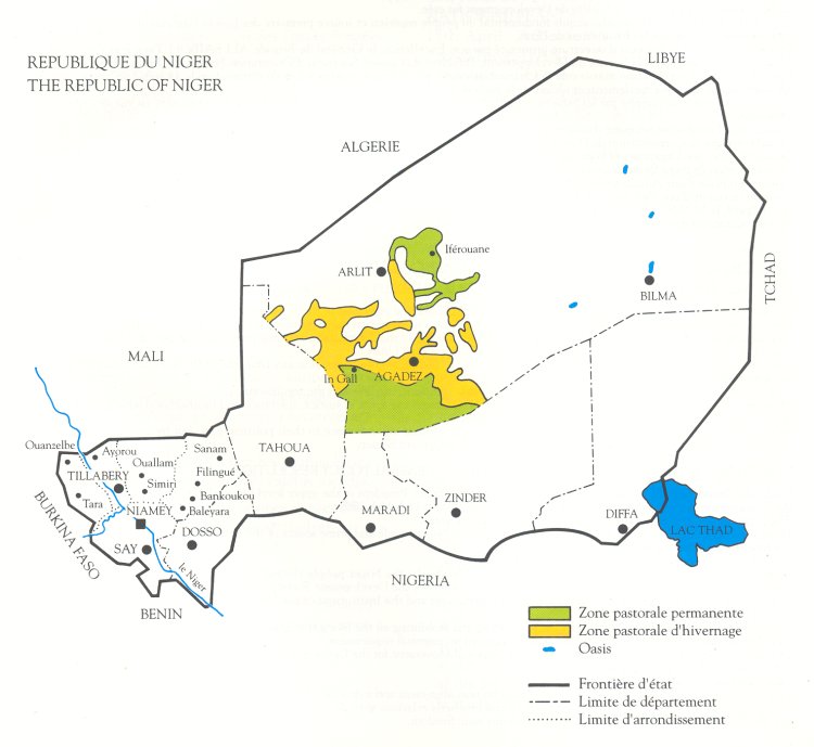
Over 20% of Nigeriens are nomadic and livestock-raising tribes, including Fulani, Tuareg, Wodaabe, Kanuri, Arabs, and Toubou.
44% live on less than $1.90/day. 87% work in the agriculture sector.
Language. The official language is French, although very few people speak it outside Niamey and even there do not expect a high-level conversation with the traders at the markets. The local languages include Djerma (spoken mainly in Niamey and the bordering Tillaberi and Dosso regions), Hausa, Fulfulde, and Tamashek (spoken by Tuaregs in the north), and Kanuri (spoken by Beri Beri). English speakers are in border towns along the Nigerian border, such as Birni N Konni and Maradi. These people are usually from Nigeria to the south and want something from you.
Country Code +227
Visa. Canada has no embassy. We must arrive before 1 pm on Sept 28 to get visas. Given the potentially long immigration queue and traffic to reach the passport office (which closes at 4 or 5 pm), it is to arrive earlier. LOIs prepared by guide.
Cost: US$2450 (8) + 5 D, 1 L, 1 BF + hotel day 9 80€. Price includes (a domestic flight (Niamey-Agadaz, $290), breakfast at hotels, single rooms, Gerewol fees $25, full board at campsites, guide, driver, transfer (3 pax per vehicle), fuel, entrance fees, administrative formalities and visit of the sites, military security) + the last night hotel $80. Need a light sleeping bag.
Adamou Issa Ibrahim. Western Union deposit USD300.+22796847279 Email: [email protected]. Address: Yantala Y-N yantala Haut. Rue Y-N/92 Commune 1, Niamey, Niger // Banque Agricole Du Niger –NE164-11001-020797660009
Swift BANENENLXXX
Currency: West Africa Franc XOF CFA. 1US$=643; 1€=655 (xe.com (July 2022)
Our guide was very inefficient. I had asked for an accounting of my payments three times but never received it (although he was constantly demanding money), he didn’t pick up any of the groups as they arrived at the airport and our passports were not processed after 3 days. He bought us SIMs and tossed three chips on a table but as they were never activated so of no use. The drivers spoke no English and were so non-intuitive that there was zero communication. On our morning flight to Agadez, he was to pick us up at 06:40 but never appeared until 07:50 with a 9 am flight. As we didn’t have our passports, getting the flight to Agadez was difficult.
In Agadez, he had not organized any of the security that we had paid 2400 € for and then wanted $3000 more. It was nothing but a shit show and broken promises.
NIGER Sept 28-Oct 7, 2022
Flight Ndjamena – Niamey NDI-NIM @23:30 – 01:45+1 (Turkish Air TK633 2’15” $759.08)
Day 1 (Wed Sept 28).
We arrived in the middle of the night with little idea how things would work as we only had a LOI but not a visa. Our passports were retained, we were given a letter and we left the airport. Lorne G from Vancouver had come on the same flight from Istanbul.
We took a taxi (10 € x3) to the Tenere Hotel, a dump for 45,000 CFA/night.
Day 2 (Thur Sept 29). Niamey City tour. River (hippos, fishing villages). No meals
NIAMEY (pop 1,026,848 2012) is the administrative capital, commercial centre, and largest city of Niger. It is possibly the least crowded and hectic capital in West Africa. Niamey lies on the Niger River, primarily on the east bank. Niger has the world’s highest fertility rate. The city is located in a pearl millet growing region while manufacturing industries include bricks, ceramic goods, cement, and weaving.
History. The French developed it as a colonial center in the late 1890s and its capital since 1926 (when it was moved from Zinder). A series of devastating droughts prompted significant population growth and by 1960 the population had grown to around 30,000. From 1970 to 1988, the economy of Niger boomed, driven by revenue from the uranium mines at Arlit. Migration for work and during droughts, as well as high population growth results in the majority of the city’s citizens being young.
Niamey sits atop two plateaux reaching 218 m (715 ft) in altitude, bisected by the Niger River.
The vast majority of the population, government, and commercial buildings are on the eastern bank with wide boulevards linking roundabouts. Two bridges connect the two sides – the Kennedy Bridge and the Friendship Bridge. The western bank area consists mainly of residential areas. Large informal settlements surround the city. In the centre are groups of poor, young, or handicapped beggars that form a well-regulated hierarchical system.
Climate – hot semi-arid with 20 to 30 inches of rain per year from June to early September, Niamey is remarkably hot throughout the year – average 32-38 °C.
See
A trip on the Niger River to Boubon (pottery production)
Musee National Boubou Hama (Niger National Museum) has a zoo, vernacular architecture, a craft centre, and exhibits including dinosaur skeletons and the Tree of Ténéré.
Niamey Grand Mosque. Niger is predominantly Muslim so mosques are the most common places of worship. This mosque was built by Gaddafi in 1977. It is lovely inside and out with lovely tiles on the columns, a nice carved wood minbar and a single minaret.
Our Lady of Perpetual Help Cathedral. Built in 1931, it is an unattractive, flat-roofed rectangle. Inside the only highlight were the black/grey, bas reliefs.
Prince Sultan Mosque. Plain outside, the large prayer hall had a nice big blue dome and one of the nicest mihrabs of nice red tile.
Grand Marche. A collection of street stalls encompassing several blocks. Caters only to the locals. We also went to a lovely artisanal shop with many things to buy. I liked the leather pillowcases adorned with designs and stitching.
Ferme Youyou. In the National Museum complex, this was as depressing as it gets, a collection of small cages – birds and a large lizard, two lions, 2 hippos in the smallest pool and more.
National Museum. A collection of white/blue buildings, one has ethnography (mostly national dress), and oil and uranium buildings.
Kennedy Bridge. We crossed, drove north and crossed Duexieme Bridge built by the Chinese.
We drove by all the huge embassy complexes.
Other places of interest include the American, French and Nigerien cultural centres, seven major market centres (including the large Niamey Grand Market), a traditional wrestling arena, and a horse racing track.
Niger River Cruise. On the way to boarding the boat, we passed through a depressing shanty town of dome tents covered with tarps and plastic. There were tons of great kids who just wanted their picture taken. It was evident that they had seen few tourists as not one said cadeaux. A kid walked beside me and with many gestures, we laughed on the water.
We sailed a long way down steam starting just at sunset. With minimal light, I saw a large “square” object. Lorne thought it was a boat but was a hippo. We ended up in a riverside restaurant and everyone had a great, tasty, cheap meal.
Day 3 (Fri Sept 30). Niamey/Agadez. Domestic flight on Niger Airlines to Agadez. 2′
With the flight at 9 am, we were told to be ready at 06:40. There was an incredibly heavy rainstorm and wind that finally lessened by 8. The drivers didn’t arrive till 08:10. I got fairly upset. The airport was ridiculous. At the security scanner, I had to unpack most of my carry-on and they removed my tweezers and two small scissors that I had gone through 100 securities with. The plane didn’t depart till 10:30 so all turned out well.
It was neat to look out the window at the Sahel unfolding beneath us. Watercourses had a line of green trees and faint areas of grass covered the land. But the rest was desert.
Telmar Hotel – pleasant enough with good A/C, the toilets require you to add the water, no lights in the BR and no wifi outside the lobby. We drove all over, had lunch at a gorgeous mud brick building with high arches and dinner at another Italian restaurant with ice cream.
Camel/goat market. This was a treat with what seemed like a thousand goats (all had one leg tied to a rope that disappeared into the ground) and a hundred camels (most young and smaller). There were a thousand pictures and more than half the men didn’t mind their picture being taken. The highlight was unloading 5 camels from a big truck. Their legs were completely trussed and with a rope around their lower jaw, several kids pushed and pulled the camel to the edge. The camel was “screaming” with full force. After the trusses were removed, more pulling got the poor animal off.
Day 4 (Sat Oct 1) (Meals: BLD)
AGADEZ (pop 110,497 2012). In the Sahara desert, the 5th largest city in Niger, the capital of both the Agadez Region and Aïr, one of the traditional Tuareg–Berber federations. The historic centre of the town has been designated a World Heritage Site by UNESCO. A trading hub along trans-Saharan trade routes for over five centuries, home to a magnificent palace and several mosques, and a gateway to the nearby Air Mountains.
Agadez has a hot desert climate.
History. Agadez was founded before the 14th century, and, by growing around trans-Saharan trade, gradually became the most important city of the Tuareg people, supplanting Assodé. (language Hausa, the lingua franca between different ethnic groups in the city)
Songhai Empire until 1591 – population 30,000 people. On route for caravans trading between the West African cities of Kano and Timbuktu, and the North African oases of Ghat, Ghadames, and Tripoli, on the Mediterranean shore. Internal fighting led to the gradual decline and by the mid-19th century, the town was a shadow of its former self.
The city still sees the arrival of caravans, bringing salt from Bilma.
Some contend that Agadez was the furthest extent of the Ottoman Empire on the African continent until the 19th century before being occupied by the French in 1906. After 1916, the French, unable to effectively administer this remote region, ruled semi-indirectly via a restored sultan. Later, Agadez became an important location in the Tuareg Rebellion of the 1990s in central and northern Niger.
In the 2010s Agadez became a major transit town for West African migrants heading to Libya and on to Europe.
AGADEZ Historic Centre World Heritage Site.
Known as the gateway to the desert, Agadez, on the southern edge of the Sahara desert, developed in the 15th and 16th centuries when the Sultanate of Aïr was established here and Touareg tribes were sedentarized in the city. Agadez was an important crossroads of the caravan trade, divided into 11 quarters with irregular shapes. They contain numerous earthen dwellings of mud brick architecture including a large amount of housing and a well-preserved group of palatial and religious buildings including a 27m high minaret made entirely of mud-brick, the highest such structure in the world. The old town is characterized by cultural, commercial, and handicraft traditions and a decorative style specific to the Aïr region.
The traditional sultanate system is still in place, ensuring social unity and economic prosperity. It is a living historic centre inhabited by about 20,000 people.

Today, Agadez flourishes as a market town and as a centre for the transportation of uranium mined in the surrounding area. This city amid the desert is safe. No tourists, but with better infrastructure than Timbuktu or even Mopti.
The old town is justifiably classified as World Heritage and the mud dwellings have been done up in recent years with European funds. Locals are friendly and surprised to see tourists. Notable buildings in the city include the Agadez Grand Mosque (originally dating from 1515 but rebuilt in the same style in 1844), the Kaocen Palace (now a hotel), and the Agadez Sultan’s Palace. The city is also known for its camel market and its silver and leatherwork.
There are inappropriate buildings made of breeze blocks, corrugated iron for roofs, an overhead electricity cable network that is particularly visible and unsightly, and the appearance of large advertisements painted on walls.
The United States is building Nigerien Air Base 201, a dedicated drone airbase in Agadez from which it can more easily monitor terrorist activities in West and North Africa, in addition to extremists coming from the Sahel.
Grand Mosque. This truly imposing structure sits on the roof of a much bigger mosque with several prayer halls. The largest has 36 square columns and a nice carpet. The roof has many air conditioners. We attempted to climb the stairway that winds its way to the top. It has a low ceiling necessitating a full crouch and is very hot with no air circulation. A convoy of bats whizzes by. Richard was the only one who made it to the top – it simply wasn’t worth the discomfort.
Surrounding Agadez. Going out of Agadez into the desert is risky, extremely expensive as well as time-consuming due to the lack of good roads. The Air and Tenere area is a full day’s drive away until the first oasis is reached, but it requires a full security outfit arranged in advance.
L’ensemble des forêts protégées de la région d’Agadez Tentative WHS (26/05/2006). All of the protected forests in the Agadez region have a forest formation of floodable tree steppe whose dominant species are: Hyphaene thebaïca, Acacia ehrembergiana, Acacia raddiana, Acacia nilotica, Balanites aegyptiaca, Calotopis procera, Ziziphus mauritiana etc… .
The Tamazalak forest, one of the main valleys on the western slope of the Aïr, is located about 110 km north of Agadez, and 90 km north of Tchirozérine. The watershed of this valley from Mount Tadgha (1853 m) to the Irhazer plain covers an area of approximately 90,000 ha.
The mineral water source is located in the forest of Tafadek. This set of forests provides wood for daily use and sale. It also serves as a grazing area and protects the breeders from the almost permanent sandstorms in the region.
The Doum Palm is one of the most widely used trees. The fruit is used to make sweet flour (Tawadaft) consumed with milk. The leaves are used for mats and ropes. The stems are cut into slats and used in house roofs.
The population of this area is predominantly Tuareg and practices livestock farming, crafts, and small trade.
We had paid security of $800 per day for 3 days or $2400. Adamou asked for another $6700 in the beginning, then dropped to $3700 and then was able to come up with $3000 of his own!!!!
We learned about the true details on Day 5. The security had increased from CFA 2 million to 3 million to 4.5 million. The price of Guerewol had increased from $600 per person to 1250 per person (and we are only there for one day). Then we learned that the real Guerewol ended yesterday Oct 1 and we are going to a private Guerewol hosted completely for tourists. This is something that E knew and failed to tell us.
As I write this, we also learned that EC has gotten a reduction of $500 privately arranged with the guide, when she reassured me that she was paying the same as everyone else. I don’t begrudge her getting something but we should have been informed. It is a matter of principle.
In the end, to proceed on our trip, we were left with a ton of money increases and costs that we couldn’t confirm. For us to leave Agadez, we had to pay an extra $3000 that the guide reassured us would be repaid when we returned to Niamey. E put in $2000 and the rest of us $200 each. The guide gave E his wedding ring as security. It is unbelievable that a festival could cost $1250 for one day. Who was telling the truth?
GUEREWOL FESTIVAL – is an annual courtship ritual competition among the traditionally nomadic Wodaabe cattle herders at the end of the rainy season in September before dispersing south on their dry season pastures.
Young men dressed in elaborate ornamentation and made up in traditional face painting gather in lines to dance and sing, vying for the attention of marriageable young women. The male beauty ideal of the Wodaabe stresses tallness, white eyes, and teeth; the men will often roll their eyes and show their teeth to emphasize these characteristics. The men’s beauty is judged by young women.
The Guérewol is found wherever Wodaabe gathers: from Niamey to other places the Wodaabe travel in their transhumance cycle, to mine salt and participate at the Cure Salée festival as far afield as northern Cameroon and Nigeria.
The most famous gathering point is In-Gall in northwest Niger, where a large festival, market, and series of clan meetings take place for both the Wodaabe and the pastoral Tuareg people. The actual dance event is called the Yaake, while other less famous elements—bartering over dowry, competitions, or camel races among suitors—make up the week-long Guérewol.
The music and line dancing are typical of Fula traditions – group singing, clapping, stomping, and bells in a style of repeating, hypnotic, and percussive choral traditions. It is accompanied by swaying line dancing called Yaake, where the men interlink arms, and rise and fall on their toes, facing a young marriageable woman. This occurs repeatedly over seven days, and for hours in the desert sun. Suitors come to the encampment of the woman to prove their interest, stamina, and attractiveness. The participants often drink a fermented bark concoction to enable them to dance for long periods, which reputedly has a hallucinogenic effect.
Full board. Tented camping – nighttime temperature 25C – light blanket. (Meals: B L D)
On the night before we were to leave for Gurewol, we met several groups that had just returned from Guerewol. The previous day, at the camp, they had experienced the same storm we had in Niamey the morning of our flight to Agadez. Things started with a tremendous sandstorm. The wind blew over and destroyed a large tent. Then the rain started and the wind blew everyone’s tents out into the desert. Everything got soaked. But they survived.
Many felt that Guerewol was an embarrassment. There were about 100 natives in a circle and 50 tourists in the middle rudely sticking cameras in people’s faces. There were several nationalities (German, Russian, Poles and a large group of 12 EPS people) who often conflicted.
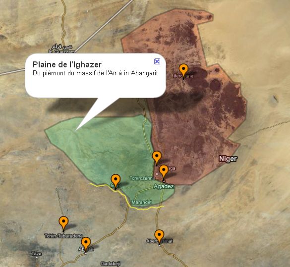
CURE SALÈE. The cure salée is a great transhumance of the herds of nomadic herders in Niger which takes place during and after the rainy season (from July to December). The plain of Ighazer wan Agadez is a clayey zone which extends from the cliffs of Tiguidt towards In Abangarit and on the foothills of Aïr. During the rainy season, it is covered with temporary herbaceous vegetation which attracts all the herds of Niger. Camels, cows, goats, sheep and donkeys set out for these pastures.
By 500 BC the first transhumances imposed by the harshness of the climate, the increasing aridification of which will reveal salty or natron sources, and will lead to the concentration of salt in the surface land, mineralized water, natron soils and grassland rich in protein. Trade increased with the advent of the camel at the beginning of the Christian era – one north-south of the Saharan populations in the dry season and the other east-west of the Sudanese populations in the rainy season.
The artesian springs were never empty, the pastures abundant, and then they return to the home soil for the dry season. This transhumance also coincides with the period of cereal crops further south, in winter the animals are excluded from the fields and then in full production, after the harvest, they return to fertilize the soil.
Three water points concentrate the animals around their wells. In these places natural springs of brackish water flow, a mineral water which will increase the water retention of the animals.
Wintering with its pastures and pools of water does not require so much work to water and graze the herds, since these resources are available almost everywhere. This will leave time for multiple social exchanges. With the large influx of people, the Cure salée became a reunion between friendly tribes. It is the occasion for many weddings and parties organized by the wealthy nomads for their prestige and that of their community.
Transhumance is not without consequence on the vegetation cover of In Gall. The early arrival of the animals hinders the growth of the grass which is immediately grazed. In the year when it has not rained well, the grass becomes insufficient, because the animals in the south graze much of it before returning. Local animals that go nowhere suffer from a lack of grass, especially in the hot season.
From 1976, the political authorities used the traditional chiefs to inform the people. They also distribute chewing tobacco, sugar, and tea to breeders, and animal vaccinations are also on the program.
Currently, everything takes place in In Gall. A site is set up to the north of the town with a stand, shade and supplies. A triumphal arch has even marked this site. Traditional huts are built to accommodate the guests. The Cure salée becomes a national holiday. People come from all over to see and sell their wares. After the official speeches, several events are organized at the site and town at the youth and culture center with other beauty contests, camel races, music contests, etc.
National and international organizations take advantage of these moments to organize training on AIDS, malaria and other diseases of the century. Savings companies show their products.
Two types of transhumance can be specified, those over long distances and those linked to local populations who nomadise on their land.
Tthe Ouelleminden cameleers from the Tahoua-Abalak region took over the area from the end of July from the west. They will also be the first to leave the area at the end of August when the wintering is barely over. They will give way to the Kel Gress coming from Damergou from the southeast, the latter only remaining for September. Finally, the Peulh Bororo lead their herd of long-horned cows to the salty springs. These habitual rhythms of occupation of the plain have also imposed themselves between populations, which through history have often been in conflict.
Thus each season the plain will increase its population by more than 10,000 people, and several thousand camels, cows, goats and other sheep, not to mention the donkeys responsible for the transport of nomadic habitats, will tread the thousand-year-old clays of the Ighazer.
Day 5,6 (Sun/Mon Oct 2-3) – INGALL. We finally left at 11:30 for the 3-hour drive to Ingall. One of the Land Cruisers had no A/C (we had already complained of this), we moved the luggage and five of us were in the one with AC as it had 2 back benches for seats. Our security detail was two Toyota trucks each with 6 soldiers and one with a big machine gun. These guys were incredibly vigilant – we were followed in any town or market.
We passed many groups of nomadic herders, mostly goats, some long-horned cattle and many donkeys. There were random water holes where they concentrated in the acacia forest.
We entered a walled compound and were greeted by a low chant from the 23 participants sitting in one corner. There were several “tents” – sisal mats covering metal frames. Most had beds on wood frames. I had already picked out the communal tent lined with mattresses for seats to sleep in. It also had an AC in the corner.
They started putting on their elaborate facial makeup and “costumes”. The 10 women appeared to be about 14 or 15 and used a simple yellow blush on their faces, Their hair was brought forward in a bouffant style. When finished the 11 young men were in a line flanked by 5 women on each side. They did a simple dance with chanting. Some had animated facial expressions with wide open eyes and blowing motions. The 5 women on each side were detached and looked bored. This carried on with minor variations. Photos were welcome and we didn’t feel intrusive.
After dinner, at 9 pm they started again with girls involved tying knots in their dangling turbans. This ensured that it was authentic.
On Oct 3, we went into Ingall and went to a goat market. The best dudes had a typical turban but also very nice straw hats. Downtown was rather dismal. A short drive out of town was some petrified wood but they were rather fragmented.
When we returned to the compound, the community played music on hand drums. Bass was from a narrow-necked pot hit with a flip flop and a huge round gourd in a water basin, again hit by a flip flop. There was a prelude to Molod, a festival starting in 4 days with the same music and dancing.
On the 4th, we spent all day at the compound in Ingall in 40° heat. That afternoon, the music and dancing from the community started again.
The night was one of the most uncomfortable I have experienced. The heat was extreme and only cooled down at 4 am. Mosquitos were dealt with a sleep sheet and Deet on arms and face.
Day 8 (Tue Oct 4) – This was a huge drive day. We left at 8 am and after a flat tire, repair of a flat tire and the window popping out of one of the vehicles, we finally arrived in Konni at 10 pm. Our only chance for food was some deep-fried sweet potato chips. The few small towns we passed through were all very depressing. The many villages consisted of an encircling wall, some small square mud-brick buildings, and round mud-brick main houses with roofs thatched with canes. There were also several small mud-brick bee-hive structures. While waiting for the vehicle with the popped-out window, the wait was enjoyable as there were many kids and mothers. Most of us tried our hand at pounding millet in the large pestles. We got to see into the thatched home of one compound – a completely bare room except for a bed with a mosquito net.
There were many water holes and herds of goats and well-fed brown, long-horn cattle. Horses and donkeys were also common.
We passed a family moving past with several donkeys loaded with all the family possessions – their home and goods. Dad, mom with a naked infant (with a large umbilical hernia) on her lap, and kids all on their donkeys.
The countryside was verdant pasture land, low rolling hills, acacia trees and light green, foot-tall grass. The road was a disaster – the main road was barely drivable as the shoulder was fragmented and the road full of potholes. 95% of the drive was on one of the multiple braided dirt roads on either side.
We continued with five in one vehicle.
Abalak was a dismal town we drove through. Transhumance zone of the nomads. Woodabe training. Grazing area.
Pond of Tablak. This large lake had lovely pastures full of cattle surrounding it.
Tahoua. We passed through without stopping.
The Earthen Mosques of the Tahoua Region (Les mosquées en terre de la région de Tahoua) Tentative WHS: (26/05/2006) The Tahoua region’s borders are: north by Agadez, west by Mali, east by Maradi and to the south by Nigeria.
The cultural landscape is marked by earthen constructions, mainly mosques made by the “architect-mason” Elhadj Mamoudou dit Falké and his apprentice, the mason Elhadj Habou. One, the Yaama mosque is recognized worldwide and won the Agha Khan Prize in 1986.
The large mosques have four minarets, of an original design (the two on the front have stairs that provide access to the roof). Inside is noted for the 8 rows of pillars that support the central dome, small domes, and the floor. The main facades have sets of reliefs and small openings. Small mosques have two minarets and generally belong to a personality (village chief, etc.).
Great Friday Mosque of Yaama was the first mosque where this new construction technique became widespread in 1962-3. It is simple and modest with only a prayer room and a single annex.
Elhadj Mamoudou dit Falké was a farmer who made several trips to Mecca in 1966. Using new architectural techniques, a renovation was started in 1977. A new roof supported by an arch and a dome required the removal of one of the columns creating free central space. Four corner towers each with two floors were added. The transformation of the mosque was completed in 1982. Other buildings such as palaces, dwellings, shelters, etc. were added by Elhadj Habou who continued the work of “the architect” Elhadj Mamoudou who died in 2002.
The ribbed central vault is compared to that of the Great Mosque of Cordoba.
Great Friday Mosque of Salewa (a village a few kilometres from Yamama) was built in 1989 by the mason Elhadj Habou.
ON KONNI Auberge Tagama. The fellow running the hotel is wonderfully pleasant. Dinner was brought in and the BF was good.
Day 9 Wed Oct 5
Konni. The shit show continues. The broken-down vehicle with everyone’s luggage arrived at 4 am so we finally had access to shampoo etc, I had a shower and a good breakfast and at 11 am there were no signs of our guide.
We went to a drum/dance show in Konni that was quite good. 4 dancers and 4 drummers had incredible energy keeping up the show for over an hour in the heat. There was a large crowd of locals and many cute kids. They all wanted their picture taken and didn’t care if they weren’t shown it. There were no requests for gifts. They seemed fascinated with us. Trying to take a photo of one kid you found interesting was impossible. You immediately had 10 or more kids pushing and shoving to get into the picture. Their enthusiasm was infectious. The show went on forever it seemed and we finally left.
We missed seeing the Sultanate – Adamo’s sister is married to him.
We drove to the Nigerian border to have a look. There were many large trucks surprisingly carrying a lot of new equipment which seemed odd. It was a waste of time.
The one vehicle had to be abandoned as it had so many issues. Adamou rented a Mercedes car to drive around Konni but then took a long time to find one to get back to Niamey. Richard paid for a car and we finally left Konni about 4 pm with Dosso the supposed overnight destination.
The highway was new to accommodate the huge line of trucks carrying gas pipeline for the supposed line to Abidjan, Cote d’Ivoire. Surprisingly the road continued to be of good quality to Niamey. The original plan was to ON in Dosso. When we arrived, apparently our hotel rooms had been given away, so we were now driving the entire 480 km to Niamey but on good roads.
Dosso is typical of all the Niger towns we have passed through since Agadez – all the most depressing places I have ever seen in the world – dirt streets, businesses are basic shacks with unbelievable collections of tires and material meant to keep the roofs from blowing off. One had deep-fried sweet potatoes that were very good.
Stop at Hasani and Fulani villages and a weekly market if coinciding with the day of your visit. Local villages use earthen materials to construct all aspects of town design and architecture. Mud mosques, adobe homes, huts with river-reed fronds, dug wells, and pastoral life. The best onions in the world, sought after by Europe are grown here, as well as peanuts. These are largely the 2 only main crops in Niger. Everything else is imported.
Balleyara Market — Two hours from Niamey, one of West Africa’s largest animal markets, plus a colourful array of other traditional markets and artisan wares (Sundays)
DOSSO (pop 59,000) is a commercial hub for trade between Niamey and the towns of eastern Niger, as well as Benin, 130–140 kilometres southeast of Niamey. Dosso is the seat of the Dosso kingdom, a Zarma chieftaincy that rose to dominate the entire Zarma region in Niger in pre-colonial Niger. The traditional ruler is called Zarmakoy or Djermakoy of Dosso, an autochthonous title meaning “King of Djermas”.
Rail: between 2014 and 2016 a rail link was built between Dosso and Niamey by the French Bolloré conglomerate to connect Niamey to the rail network in Benin and thus to the coast. But competing commercial interests by several parties resulted in endless litigation and the connection to Benin never materialized. So the 145 km Niamey-Dosso stretch now lies orphaned and unused, with the tracks ending in the middle of nowhere some 6 km south of Dosso. After 5 years of neglect, the tracks are already damaged to such an extent in some places, that they have become unusable.
The Palace of the Chief of Province of Dosso Tentative WHS (26/05/2006). was built in 1904 by Zarmakoye Abdou Augusta. The reign of the Zarrmakoye began in the 15th century when Boukar son of Tagur Gana settled in Zigui. From this period, there have been a total of 8 Zarmakoye all buried in a cemetery. The palace is an imposing building in good condition surrounded by a surrounding wall.
There is also an ancient well in the women’s courtyard of the palace.

Day 9 (Thur Oct 6) –Koure National Park and Giraffes
Giraffe Zone Tentative WHS (26/05/2006). Biosphere Reserve in the W Niger National Park containing ” Giraffa camelopardalis Peralta” , the last population of giraffes living in West Africa.
Getting there is complicated. A permit is required and needs to be arranged by your guide at least 24 hours ahead. We organized it at an office in Niamey. With it, you register at the gate. The trip also requires a full security detail of the army in two vehicles. In 2020, 6 French workers and a local were killed by jihadists in Koure, despite feeling it was completely safe.
The giraffe was widely represented in West Africa at the beginning of the 20th century (Senegal, Mauritania, Mali, Nigeria, Niger). The introduction of firearms (resulting in intensive poaching), combined with increasingly strong anthropogenic pressure (expansion of agriculture, clearing, and uncontrolled deforestation) led, from the 1950s to the massive disappearance of giraffes from all West African countries except Niger.
Other mammals include Gazelles, warthogs, and a few small carnivores.
Giraffes move all year round between the Dallol (November to May dry season) and the Kouré plateaus (June to September and until November depending on the rainfall) linked to the annual cycle of vegetation and the availability of drinking water.
The population was 45,000 in 1999. It is sedentary and Zarma, Peulh, Hausa and Tuareg practice agriculture, livestock, fishing, crafts, small trade, and the marketing of wood through markets.
Kouré is a rural community located 60 kilometres east of Niamey. Kouré is best known for West African giraffes (Giraffa camelopardalis peralta), an endemic subspecies of West Africa. The population of giraffes in Niger reached a low of 48 animals in 1984, but there are now 600 of them. The local community makes bore holes, cereal banks, grain mills, seeds, and fertilizer to encourage them to protect the giraffes, which can be destructive to crops. However, the population of giraffes is threatened by the loss of the tiger bush habitat, which is gradually being cleared for agriculture.
Read about giraffes or see the Oct 2019 issue of National Geographic.
Return to Niamey: ON Tenere Hotel 45,000 CFA
Day 10 (Fri Oct 7) – Fly Burkina Fasso. Depart Niamey – Ouagadougou, NIM-OUA @ 8:20-8:25 am Air Burkina (co-share Ethiopian Airlines but higher price) ASKY Airlines KP047 (C$395 direct 1h 5m, one-way)
OTHER DESTINATIONS
Niger River and W Park. Overlook that stretches far into the distance to the frontier of Burkina and Benin. Take to raised lookout platforms to watch elephants come to the waterside to drink and shower themselves.
Dosso Partial Faunal Reserve protects animals of the W Transborder Park complex, most notably African elephants, Hippos, types of gazelles, and the West African Giraffe (Giraffa camelopardalis peralta). This reserve marks the southern end of the migration path of the last sustainable herd of West African Giraffe, who travel north to the region around Kouré (some 80 km southeast of Niamey) in the rainy season. The tiger bush uplands around Kouré are not within a formal park but are a center for tourism and Giraffe conservation, and the herds have protected status in Niger. The Dosso reserve provides forage and homes for the Giraffe in the dry season, and the area has restrictions on woodcutting and habitat damage which would affect Giraffe sustainability. NGOs near Kouré promoted woodcutting businesses in the late 1990s which profoundly altered the habitat and drove some giraffes to raid local gardens for food, making the protections offered by the Dosso reserve crucial.
Maradi. Centre of agriculture (especially peanuts), home to a colourful chief’s palace, and near seasonal rivers/floodplains which have caused interesting land formations to the south. Visit the grand mosque, the Sultan’s palace, the old city market and the artisanal center.
Zinder. Niger’s second-biggest city and the cultural capital of Niger, this Peul-Hausa city has perhaps the most colourful craft markets (pottery & tanning are local specialties) as well as a noteworthy regional museum and sultan’s palace and busy, bustling town. The people are mainly Hausa, culturally very different from the Tuaregs in the Agadez area.
Visit the Grand Mosque, French Fort, Sultan’s Palace (the best view of the city is from atop the palace), regional museum, cattle market and artisanal market, alternative Radio Station and a local village. The old center of Zinder with the Birni and Sultanat quarters are a tentative WHS (La vieille ville de Zinder, quartier de Birni et le Sultanat (26/05/2006) – minarets and mud houses, intricately carved doors, glazed windows, and otherworldly architecture of Zinder Nigerien tradition.
WORLD HERITAGE SITES
W-Arly-Pendjari Complex World Heritage Site. Trinational complex of W Regional Park (shared between Benin, Burkina Faso, and Niger), Arly National Park (Burkina Faso), Pendjari National Park (Benin), and the hunting zones of Koakrana and Kourtiagou (Burkina Faso) and Konkombri and Mékrou (Benin).
Inscribed in 1996 on the World Heritage List, it is located in the transition zone between the savannas of the Sudanese region and the forested Guinean region, with vegetation types including grasslands, shrublands, wooded savannah and extensive gallery forests. It includes the largest and most important continuum of terrestrial, semi-aquatic and aquatic ecosystems in the West African savannah belt. The property is a refuge for wildlife species that have disappeared elsewhere in West Africa or are highly threatened. It is home to the largest population of elephants in West Africa and most of the large mammals typical of the region, such as the African Manatee, cheetah, lion and leopard. It also harbours the only viable population of lions in the region.
The long-term effects of fire linked to human occupation, perhaps dating back some 50,000 years, have shaped the vegetation of the property, and the continued traditional use of fire maintains the diversity of vegetation types, which in turn provide habitat for the property’s characteristic wildlife.
The Complex includes the largest and most ecologically secure elephant population in West Africa, representing 85% of the region’s savanna elephants. It also protects almost the complete assemblage of characteristic flora and fauna, providing crucial habitat for most of the large mammal species typical of West Africa and the only viable population of lion in the area and probably the only population of cheetah in West Africa. The site exhibits particularly high levels of endemism among fish species and is home to seven of the nine endemic fish species reported in the Volta Basin.
An overlook has views that stretch far into the distance to the frontier of Burkina and Benin. Take to raised lookout platforms to watch elephants come to the waterside to drink and shower themselves.
“W” National Park, Archaeological Sites (26/06/2006). Prehistoric sites, in particular Paleolithic, along the Mekrou; the remains of the Kasbah of Koulen and about sixty sites hidden inside the Park. Numerous prehistoric populations succeeded one another along the Mekrou in a long sequence uninterrupted from the Acheulean to the sub-current, passing through the recent Paleolithic, the Neolithic and the appearance of iron metallurgy.
Air and Tenere Natural Reserve World Heritage Site
This is the largest protected area in Africa (twice the size of Switzerland), covering a vast swathe of desert and semi-desert land on the edge of the Sahara. At the time of inscription, it supported a diverse desert fauna and was considered to offer hope for the preservation of viable populations of desert antelopes such as addax, dama and Dorcas gazelles as well ostrich and barbary sheep. Other key desert species disappeared earlier, notably the scimitar-horned oryx, last seen in 1983. Since then, a period of civil strife in northern Niger, and lack of management capacity, has resulted in a catastrophic decline of all the larger species – ostrich, dama gazelle and addax seem to have disappeared completely, and populations of Dorcas gazelle and barbary sheep are now much reduced.
Important habitats for the survival of endangered species. The reserves of Air and Tenere provide the best opportunity for survival of the desert-adapted wildlife species typical of the Sahel-Sahara regions of Niger and the wider Sahara desert. The isolation of the AirMountain massif and the historically low human population has allowed the survival of many species that have been eliminated elsewhere in the Sahara and Sahel. The world heritage site contains important natural habitats for three species of endangered desert antelopes: the Dorcas gazelle (Gazella dorcas dorcas), Rhim’s gazelle (Gazella leptoceros) and Addax (Addax nasomaculatus). In addition, the area supports desert-adapted carnivores such as Fennec (Vulpes zerda), Rüppell’s Fox (Vulpes rueppellii) and Cheetah (Acinonyx jubatus). In total, 40 species of mammals, 165 species of birds, 18 species of reptiles and amphibians have been recorded in the reserves. The Air massif also serves as an important transit area for many Afrotropical and Palearctic migratory birds.
Wide variety of desert and semi-desert habitats. The juxtaposition of the high Air Mountains and extensive dune systems of the Tenere desert has led to the development of a dynamic complex of interdependent habitats. These include vast areas of mobile sand dunes alongside fixed dunes, ergs, valleys, cliffs, canyons, rocky plateaus and occasional water sources. In general, the Air Mountains support a more Sahelian flora and fauna (on account of the slightly cooler and wetter environment in the mountains), with more woody species of vegetation (such as Acacia ehrenbergiana, Acacia raddiana, Balanites egyptiaca, Maerua crassifolia). The major valleys radiating out of the massif (which benefit from underground water) also support a diverse woody plant community including doum and date palms, Acacia nilotica, Acacia raddiana, Boscia senegalensis, Salvadora persica, and a herbaceous layer with grasses such as Stipagrostis vulnerans. Beyond the immediate influence of the mountains, there are vast expanses of sand and some of the highest dunes in the world with the occasional oasis. These habitats provide the key elements essential for the survival of the area’s desert-adapted animals.
Desert landscapes of exceptional natural beauty. The AïrMountains owe their origins to past volcanic events and their course-textured rocks in black and ochre hues contrast vividly with the golden desert sands that pile up in massive dunes against their flanks. Isolated trees, contorted by the rigours of their desert existence and occasional splashes of green in unexpected places draw the eye through a magical landscape that changes with each new vista. In the distance, ridges of blue-and-white marble rise out of the golden sands like the crests of massive waves in this remote sea of sand. Visitors to such a place cannot fail to be moved by its austere beauty.
Tentative WHS
The Niger River, the Islands and the Valley (26/05/2006) Located in the far west of the country and watered by the Niger River, the Tillabéry region covers an area of 91,199 km 2. It is bounded to the north by Mali, to the west and southwest by Burkina Faso, to the south by Benin, to the southeast by the Dosso region, and to the northeast by Tahoua.
The Nigerien part represents 21% of the entire watershed in the middle and stretches from Timbuktu (Mali) to Malanville (Benin) covering vast desert areas, flood plains and marshy areas in large valleys that gradually dry up.
The Niger River and its tributaries have crocodiles, hippos, manatees, antelopes, and carnivores with significant wildlife potential.
The population of the Niger River is estimated at 2,700,000 inhabitants. It a mix of populations: Zarma, Wogo, Haoussa, Peulh, Tuareg and for a good part, Songhaï and Djerma, mainly farmers, fishermen and boatmen who live along the river. This cosmopolitan population also practices agriculture and animal husbandry.
River navigation is an important activity, both for the transport of goods and for the transport of people. However, this is conditioned by the topography and the depth of the river water. It is not possible all along the river and you cannot sail all year round.
From Tillabery to Koutougou are 14 islands. The history dates back to the 1st century of the Christian era. The traditional architecture consists of dwellings painted and decorated by women.
The Yassan mound overlooking the Niger River is a gathering place for hippopotamuses and rock carvings on slabs. In Kourki, there are rock carvings with human and animal representations.
The region of Tillabery is the zone of contact between two great ancient cultures – the fine terracotta beads of Yatakala (IVth century AD) and on the other side, the funerary statuary in terracotta and in stone from the sites of Bura and Lourgou (2nd century AD).
Le site de Lougou (26/05/2006). Located some 350 km east of Niamey, this is the oldest location of the people of Arewa and includes a mythical stone of justice “Tunguma”, the tombs of the various Saraounia Queens, and the battle site of the French column Voulet and Chanoine.
Aldjima Gado is the current queen. One of these queens, the Saraounia Mangu opposed the French column Voulet-Chanoine in 1899. This completely bare and abandoned battlefield is still littered with human bones,
Ounsol or N’Solo Pond (26/05/2006). The Ossolo site is located in the far west of Niger, 30km northwest of the town of Tera. Ossolo is a semi-permanent pond, fed by runoff water and with Acacia nilotica. It covers an area of 9000 ha.
The Dargol River (source in Burkina Faso) crosses the pond. The Ossolo pond lasts 7 to 8 months: December – 80 ha; rainy season – 3 km long and 400 ha.
Mammals include the red-fronted gazelle, hares and squirrels. 20 years ago, there were also Hartebeests, warthogs, lions and Buffalos. Fish farming lasts from November to February due to the drying up of the pond in February/March.
Three distinct communities around the Ossolo massif. Songhaï (6,899 east), Tuareg (1300 southern and northern parts of the massif); Fulani groups (1,700 west to the Burkina Faso border.
Bura Archaeological Site (26/05/2006). In the middle Niger valley 150 km northwest of Niamey. Bura Necropolis was accidentally discovered in 1975. The excavated part is 25 m long by 20 m. The Necropolis part has jar-coffins or anthropomorphic funerary urns surmounted by the heads of statuettes, placed upside down on the ground and containing human skeletons. The religious altar part has large blocks of stones.
The Classified Forest, Lake Madaraunfa and the Tombs of the 99 Saints (26/05/2006). The Madarounfa forest is about 1 km north of the lake. 830ha. Refuge for an abundant and varied birdlife (storks, ducks, teal, knights, camerons, pelicans, etc.). It is characterized by vegetation whose dominant species consist of: Mitragina inermis, Diosperos mesphilimermis, Acacia albida, Haephaene thebaïca, Piliostigma reticulatum.
The tombs are around and in the lake. From the dawn of time to 1990.). The spirit of a Saint who settles on the site by an apparition of visible light at night, particularly on Thursday evening. Following this “announcement”, the population built the tomb in the designated place, which became Saint’s place of life. The number 99 attributed to the Saints also corresponds to that of the rosary used by Muslims.
The area is 800 hectares, but it is not developed despite the regular frequentation. The tombs are rectangular low walls, the largest measuring 15m by 5m and 45cm in height.
Réserve de faune de Galbedji (26/05/2006) The Gadabédji wildlife reserve is located north of Dakoro, at the gateway to the Sahara desert. This zone covers an area of 76,000 ha. The climate is of the Sahelian type with a dry season lasting from October to May. There are several temporary ponds located inside the reserve. 150 cemented wells surround the reserve on either side. Gallery forests (coverage rate of 60%) are concentrated here and there in depressions serving as temporary ponds in the rainy season.
Formerly, composed of several species, the fauna of this region can be summed up in a few relict populations of Dorcas gazelles, patas monkeys, jackals, fennec foxes, various reptiles, etc. The avifauna is made up of the following species: Oricou, ruppel’s gypsum, Nubian bustard, pharaoh’s hen, great Arabian bustard, brown vulture and migratory and sedentary birds. The population is Hausa, Tuareg and Fulani. Livestock is the main socio-economic activity in the area.
Gisements des dinosauriens (26/05/2006) Dinosaur Deposits. The end of the Triassic to the Lower Cretaceous, contains deposits of silicified wood and dinosaurs, the most important of which is that of Gadoufaoua, 150 km southeast of Agadez and the In Gall region.
The northern territory of Niger offers a chance in Africa to follow the evolutionary dynamics of continental vertebrates throughout the Cretaceous period. In Gall deposits corresponds to the period when South America was still attached to Africa; In Abangarit corresponds to when the separation of the two continents was in action; In Becceten deposits corresponds to when Africa had become a mega-island, completely isolated from South America and Eurasia; and finally, the group of Tillia deposits corresponds to the period when bridges were again established between Africa and Eurasia.
The main deposits are in the Tillia region, Abangharit, Gadoufaoua and Gall-Marandet. Currently, five dinosaur and crocodilian skeletons are on display at the National Museum of Niger in Niamey.
Itinéraires Culturels du Désert du Sahara : Route du sel (26/05/2006) Cultural Routes of the Sahara Desert: Salt Route. The Salt Route starts from Air, crosses the Ténéré desert and finally arrives at Bilma where the salt pans are located, a place where the salt essential for transactions is extracted. This route was the subject of a caravan trade for several centuries.
At the heart of the transaction: the exchange of millet for salt and dates. The Tuareg Kel Ewey are the most attached to this activity. Thus the caravans always leave grouped, bringing together between 3,000 and 20,000 camels to face the desert and the looters, but above all to face the raids of the Toubou from Tibesti. The Salt Route is therefore extremely perilous because of 2 elements: the Ténéré desert and attacks and other raids.
During the French penetration, insecurity constantly threatened trans-Saharan trade. Méhariste companies were then created to escort the caravans. At that time the saltworks of Bilma recorded the passage of 7000 to 30000 dromedaries per year.
In December 1916 in Agadez, the revolt of the Senoussists led by Kaocen against the French occupation had temporarily put an end to these caravans. They had not resumed until 1920 and their importance continued to increase. In 1988, 5000 dromedaries reached Bilma.
With improved security, the men dared to face the dreaded desert in small groups. The caravans placed their fate in the hands of a single man, the “Madougou”, who alone knew the way.
The caravan route had to pass through the famous Ténéré tree to the east of Agadèz where the animals drank one last time before the big crossing. The caravan cycle lasted 9 months. From June-July to September, the men stayed in the bush, leaving their herds to graze. From the end of September, laden with millet and products from the Aïr, the salt caravan took them to the Bilma saltworks. Crossing the ténéré round trip in about 35 days, they travelled 1200 to 1500km: it is the “Tafordé” or the salt road or “Tarlam” the line of camels.
On the way back, the caravan split up and small groups descended towards the south of Niger with salt and dates, it was the “Airam” or the millet caravan. After selling their salt on the regional markets, they bought the millet as soon as the harvest began. They then stayed 3 months in Hausa country, the time for the camels to redo the hump by stuffing themselves in the millet fields after the harvest. In exchange, they left the manure in the fields.
They finally returned home in June with the millet and other foodstuffs. 3 months later, the rainy season was over, and they left with the millet for a new cycle.
Plateau et Fortin du Djado (26/05/2006) Plateau and Fort of Djado. The Djado site is a very old fortified complex, located in one of the most inaccessible regions of mountains and hyperarid plateaus of the central Sahara. Numerous lithic rock sites and ruins of ancient cities. Hyperarid ecosystem in which large ungulates such as mouflons and gazelles survive. The Djado is also a migration corridor for Addax between Algeria and Chad via Niger. As such, it constitutes an important corridor for biodiversity.
==============================================================
Warning. Most of Niger is unsafe for any travel. The capital, Niamey, is safer only by comparison and even that city is dangerous to visit. Areas near the Mali border are essentially lawless. Islamists with ties to the terrorist organization al Qaeda in the Islamic Maghreb (AQIM) control the regions of Mali bordering Niger. Western tourists have been kidnapped and at least two have been killed by an al Qaeda affiliate. Agadez has seen periodic unrest for several years and at times the government has required special permits to travel in the region and military escorts for convoys of vehicles. The Nigerian government recommends armed escorts when travelling in the region. Travel north of Niamey or to Northern Niger is strongly discouraged; there is a heightened risk of armed robbery north of the Tahoua-Zinder-Diffa axis.
Get In
Visa. Visas are required by all nationals except nationals of several African countries.
Yellow fever is mandatory, but Cholera vaccination certification is required only if travelling from a neighbouring country with a recent outbreak.
By plane. There is one international airport (Aéroport International Diori Hamani de Niamey) in Niamey. In 2019, there were connections to Zinder, Maradi and Agadez.
As of August 2017, there were flights from West and North African capitals, Istanbul, Paris, Algiers, Ouagadougou, Abidjan, Addis Ababa, Tripoli, Casablanca, Lome, and Tunis.
At the airport in Niamey there is a taxi monopoly and the lowest you’ll get a taxi for is CFA 3,000 – and that’s if you haggle a lot! However, if you walk south from the airport you’ll hit the main road and for CFA 100-150 you can get a ride from a beat-up van to the Grand Marché (Main Market), luggage included.
By car. Travellers can get to Niger overland by roads from Mali, Burkina Faso, Benin and Nigeria. Some adventurous souls still cross the Sahara from the north (Algeria), but that area is not secure.
By bus. Lomé and Cotounou, Abidjan, Bamako, Dakar, Nouakchott (all through Ouagadougou). The service to Gao in Mali was suspended due to security reasons. Along the Nigerian border, there are local minibuses and taxis which connect Maradi and Zinder with Katsina and Kano. Normally you do not have to change vehicles at the border.
Get Around 10,000 km of highways, over 2000 km are paved.
By bus. Cars are dangerous, extremely hot, more expensive and are forced to pull over after midnight due to banditry. Because these cars often only leave in the evening, it can take several days to travel a relatively short distance. The large buses are new Mercedes buses with a soldier at night so they may drive all night long. In addition, due to their large size, they can skim over potholes that would destroy the smaller vans.
TOURS
1. Junior (real name Abdoulaziz). [email protected]
Phone +22797354998
2. Agadez Expeditions/Auberge d’Azel
E-mail: [email protected]
Phone: +22720440170
Website: http://www.agadez-tourisme.com/en/auberge_en.html
Akli and Celine own and run this Auberge in Agadez, a true gem. They are not fixers as such, but do know the area well and can help with the whole Agadez region.
3. Tidene Expeditions, BP 270 Agadez, +227 440568, fax: +227 440 578
Learn Patience. If you haven’t learned it before you went to Niger, you probably will.
Stay Safe. Niger is politically unstable and lawlessness is widespread. Follow independent news closely and stay in contact with your embassy. Vicious and sadistic Al-Qaeda and Boko Haram members are present in Niger and have kidnapped and killed many, so it is essential to know the off-limit regions and avoid them: the region north of Agadez, avoid driving late at night in a private vehicle (armed robbers). During the day, police checkpoints on the main highways limit criminal activities.
The main annoyances are young boys shouting “Anasara” – ‘foreigner’. You will be asked for a ‘cadeau’ – ‘gift,’ pretty much every time you see a person outside your hotel.
In Niamey, the safety level is better. Stay away from markets (pickpockets or handbag straps being cut) and after dark and use taxis and are EXTRA careful to avoid where the streets cross ravines, you shouldn’t run into any problems.
Carrying a backpack and camera, looking like a tourist, and especially being white, will draw some unwanted attention. Most of the attention is from people who try to get your money legally, either by selling you a toothbrush or by begging, but there are always a few less honest people.
Health. Drink lots of water. Wear loose conservative clothes, big hats, and lots of sunscreen. If in doubt, wear what the locals wear.
Malaria, including encephalitic malaria, is a problem and is chloroquine resistant in Niger. Take your prophylaxes, use heavy-duty insect repellent (DEET is best, though nasty), and consider carrying a mosquito net to sleep under.
Giardia and amoebic dysentery are common. Be wary of any roadside food, unless you buy it hot off the grill. Even items fried in oil could make you sick if the oil has been heavily used and is old. Best to avoid salads and uncooked veggies. Also, never drink unfiltered water (including ice).
Schistosomiasis is present in most water bodies in Niger, so travellers should avoid going in the water everywhere — except chlorinated swimming pools.
In case you were unable to stay healthy, the Clinique Pasteur (situated in front of the Lycée Fontaine) has clean facilities, sterile needles, and competent, sympathetic doctors. The Clinique Gamkalley and many other clinics are around, however, you may need to watch out for dirty needles, over-prescription and aggressive staff.
Respect. Visitors are treated as kings in Niger, so be careful not to abuse the hospitality. Try to accept all the small tokens and gestures (cokes, tea, small gifts, etc.) that are offered to you during your time in Niger. It isn’t good to refuse too much and don’t think “These people are too poor to give me these things”. That is offensive as taking good care of guests is a point of honour and gives people great pleasure. Don’t comment out loud when you see poverty or things in disrepair and please don’t remind Nigeriens about how poor their country is.
Dress conservatively, which means no shorts, no skirts above the knees, and no tank tops. For women, dressing revealingly can be seen as very offensive, even in Niamey. Also, dress nicely, as clothes determine how well you are treated back.
Always ask people, especially camel drivers, market sellers, and the elderly, before taking a photograph. Many Nigeriens still find it offensive.
Slavery is still relatively common in the central areas, away from the towns. You can generally spot slaves by the unadorned, solid ankle bracelets on both feet, which look like manacles and may well serve that purpose. Unless you feel particularly brave, discussion of the subject with either victims or perpetrators is probably best avoided.
==============================================================Gerewol Festival, Chad. The end of the rainy season ends in late September or October, and Gerewol is planned shortly after that. That means your provider will not know the dates until a couple of months beforehand. a great, non-touristic experience. This festival is not set up for the benefit of the foreigner but is a tradition that dates back for generations.
Security. With the Wodaabe people, I felt completely safe and secure. But Chad is a country under duress from terrorist threats on the borders, a president who died after 30 years in power, and general insecurity in N’Djamena. The US State Department ranks Chad Level 3, reconsider travel to the region. In general, don’t take photos of the capital, it is not appreciated. Of course, security can always change, so do your research before you go.
Covid. I needed a Covid test to enter the country and a Covid test to exit. Our tour provider arranged for our COVID tests to be taken at the hotel for $50 the day before our flight. Otherwise, the country for the most part acts as if there is no Covid. There were no masks or precautions at the festival.
Language. The Wodaabe speak their own language and the Chadian dialect of Arabic. So communication (unless you know these languages) with them is a series of smiles and gestures.
Asking for free stuff. The Wodaabe have very few belongings as they are nomadic and have very little money. They are intrigued by some of the trappings of the West. They will grasp or point to your watch, phone, or sunglasses. This happens often, but they are not aggressive. They also have a yearning for your socks. I thought this was a bit odd, but I imagine our socks are newer and cleaner.
Sadly, another desire for the Wodaabe is water. There is a limited water supply where we met the Wodaabe and sometimes requires long walks to retrieve more water supplies. The Wodaabe will point and motion to your water bottle. I felt a pang of guilt in refusing them, but we interacted with hundreds of Wodaabe and we had limited water supplies in our camp.
Reverse aquarium. If you are going to the Gerwol Festival, you are probably intent on taking a ton of photos. And for the most part, the Wodaabe are ready to oblige. I took several thousand photos during my visit. While I interacted constantly with the Wodaabe there were breaks during the day. Our group would retire to our camp to escape the blazing heat. At times, some of our new friends would gather and observe us … eating, talking, or taking an afternoon nap. It seemed fair to me since we were constantly watching and taking photos of them.
Cell phone. As I mentioned before, the Wodaabe had very few belongings, but a minority had mobile phones. These phones were smartphones, but the equivalent of something you would see in 2004. The phones had a camera and an antiquated 2 MB photo. And just like us, they enjoyed taking selfies and photos of each other.
There was also a reverse aquarium effect regarding the camera where some of our new friends would take photos of us or ask us to join in a photo with them. I was happy to oblige.
Chairs. We take so many things for granted. And there was one thing I noted that really was an eye-opener. At our camp, we had a series of chairs set up under some trees for shade. We would relax here and some of Wodaabe friends would come visit us. Sometimes, some of the courageous youths would grab an empty chair and sit down and join us. At some point, I realized this was a guilty pleasure for them. The Wodaabe do not have chairs in their society.
Photography. It is pretty much open season to take photography. Of course, be respectful. The men enjoyed the photos more than the women and girls. They were a bit elusive and waved off the photos. The subjects always enjoyed seeing the photos, so please share with them so they can take a look.
Independent verse Tour Provider. In short, it is not feasible to do this trip independently. First, our trip from the capital, N’Djamena, took a day and a half. This trip was initially over paved roads to dirt roads to off-road completely. There is no public transportation option. Second, the Wodaabe are nomadic, meaning there is not necessarily a fixed point until possibly the day or two before you get there. You need to have a Wodaabe contact to know their precise location. Third, I believe you need to have a personal relationship with the Wodaabe to spend time with them. You can not simply just show up and embed yourself with the tribe. Fourth, you are isolated with no resources. The Wodaabe are in the bush, there is no nearby town or village. You would need all of your supplies to sustain yourself over multiple days.
The Neighborhood. The day was typically broken into several segments … a morning walk of visiting families and watching the men prep, lunch and a rest, followed by another walk which transitioned into the performances, then dinner, and at night back to watch the men perform. After a while, you would see and recognize the same people. It was like running into an acquaintance on the street or local pub back home except you were in the savannah. My BFF ended up being Ikey, around 10 years old. I ended up seeing him everywhere and I would yell out a big “osee (hello) Ikey”. Ikey wasn’t nearly enthusiastic about seeing me, but he made my day.
The two groups who came to the one in Chad also had wildly different costumes and makeup (and even could be identified without makeup by the fact that one group practices intense scarification)
