
Bosnia and Herzegovina – Federation Herzegovina (Mostar, Tomislavgrad) March 25, 26, 2019
Kravice Falls. The Trebizat River braids through several bushy islands to form a long amphitheatre of waterfalls 120m long. It drops 26-28m and forms limestone travertine. Below the falls are many mills. It reminded me of Kalendula Waterfall in Angola because of how wide it was. 10Km.
it was a 29km drive off the expressway but the road bridge crossed the river about 500m downstream from the falls.
MOSTAR
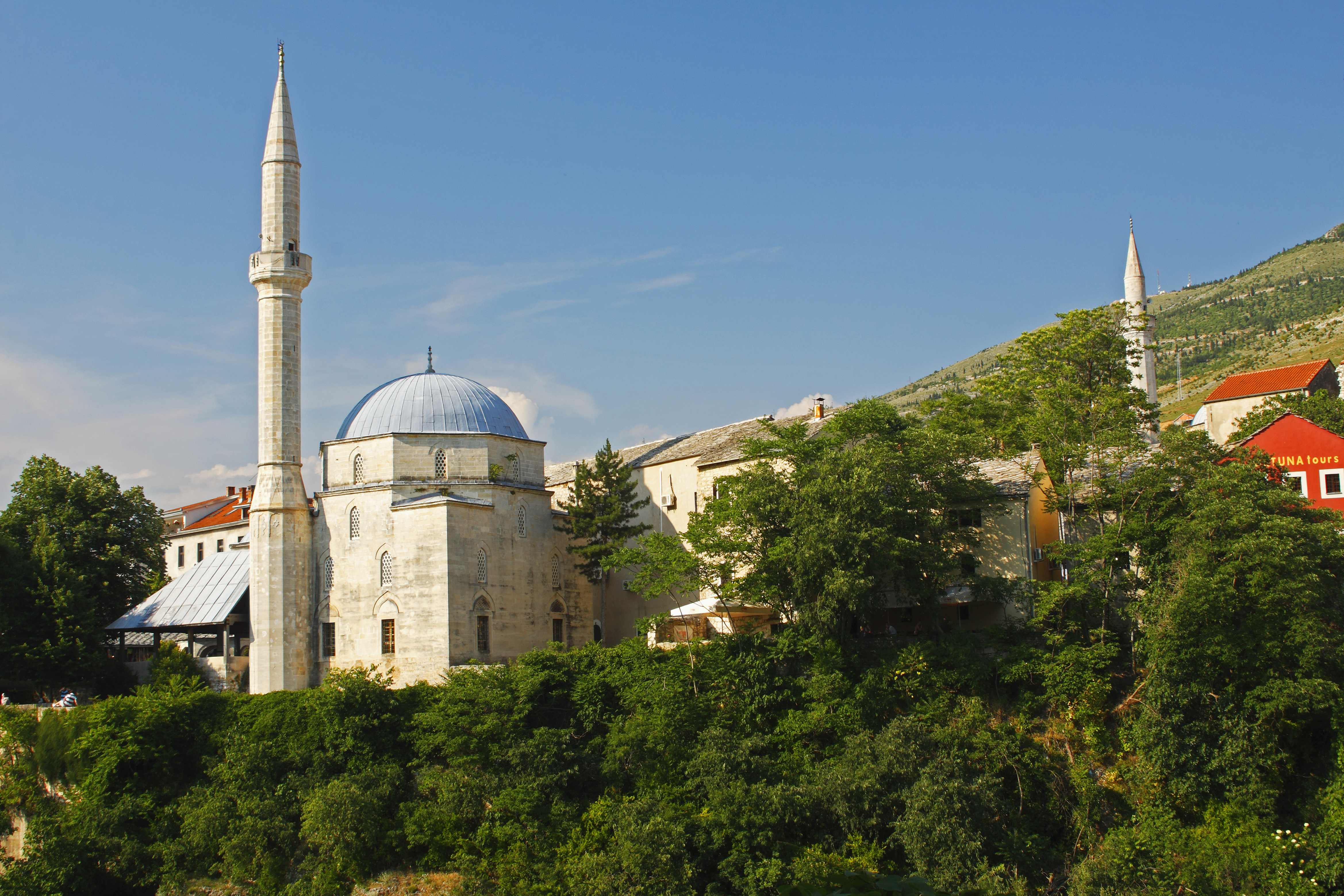
Koskin-Mehmed Pasha’s Mosque. With the best views of the bridge, this mosque sells admission to enter the patio and see inside. Built in 1618, it is only one of 5 mosques in the immediate vicinity. With 3 arches each with a small dome at the entrance, the inside has a nice mihrab and mosaics on the dome. It has one minaret and does not appear to be a functioning mosque. €6 or 12Km
Nesuh-Aga Vicyakovic Mosque. I parked in front of this small mosque thinking it was the Pasha’s Mosque. Built in 1528-29, it was closed in 1961, used as a warehouse, abandoned, damaged in the 1992-95 war and restored in 1997. The small graveyard was full of tombs all with the same date, 1994.
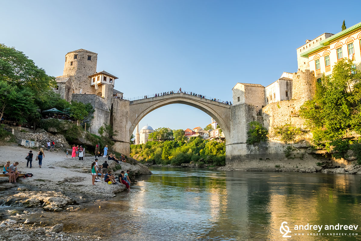
Old Bridge Area of the Old City of Mostar was Declared a World Heritage Site in 2005, it is the tourist attraction of Mostar. The river is lined with round cobble streets and scads of restaurants. The bridge has a lovely form with its high arch. The limestone pavers are slippery. I crossed and ate a traditional BH meal at a restaurant and walked all over on both sides. The souvenir stands has many Turkish coffee sets, and unusual mosaic lamps and dishes.
OKC Abrasevic. In the NM Entertainment series, this is a small 2-level bar about a km north of the bridge. The ping pong table in the courtyard seemed to be the most action.
I was awake at 5 am – any religion that makes you get up and pray at this hour has got to put you in a bad mood. It was extremely windy. BH has a garbage problem reminding me of much of Mexico with plastic bags plastered against the fences.
BLAGAJ
Blagaj village is about 15kms south of Mostar and is the tentative World Heritage site: The natural and architectural ensemble of Blagaj (11/12/2007). Drive 1.5kms past the village center (2 small churches and one mosque), park and walk 250m through a gauntlet of 42 tiny souvenir stands.
Blagaj Tekke. This is a 15th-century Dervish house built in traditional Balkan architectural style (looks very modern from the outside) containing the tomb of Arik Pasha, the founder of the Baktasi Sufi order. €2.50
The setting is majestic under a 310m limestone cliff with a 15m wide cave from which flows the Buna River, the largest karstic river in Europe with a flow rate of 43 cubic metres per second. It immediately falls over a short drop.

POČITELJ
Another Tentative WHS – The historic urban site of Počitelj (02/01/2007), it was first built in the 1440s under a limestone cliff along the River Neretva. When the Ottomans conquered Bosnia in 1463, it became a strategic defence stronghold against the Hungarian/Croatian kingdom, which took the village in 1465. Towers and walls were built but the Ottomans reconquered it again in 1471 and it became an ordinary town. After the Venetian conquest in 1693, it was refortified and the town reached its maximum importance and size. I declined after the Austrians and was largely abandoned until the 1940s. Tourism arrived with a new road in the 1960s. Park at the bottom and walk up the steep stairs. It is difficult to defend as the entire top of the hill is long and easy to access (after climbing all the way up, I encountered a road). I had wondered why there were so many houses at the top of the village. The town has a madrasah, Haman (bath), and clocktower.
Gavrakapetenovu House (late 16th century) is the largest house and became an artist’s colony from 1961-75. Vandalized in 1993, it was restored in 2003.
Hajji Aliza Mosque. Dating from 1563, it has a carved ornament on the base of the minaret. In 1993, the dome and minaret were destroyed and it was reconstructed in 2005. There is a mammoth cedar tree in the courtyard.
Gavrakepetan’s Tower. This fort ruins and tower are within the upper town walls.
The long 5m-high bastion at the top consists of Kulina, the gate, Bastion of Pilavazrids and Pasha’s Bastion (with a tower, it is being restored and the gate was locked but would have commanding views in all directions).
STOLAC
The municipality is traversed by the River Brigava and is a Tentative WHS: The natural and architectural ensemble of Stolac (11/12/2007). The Old Town has traces of the Illurians, Greeks, Romans, Slovenes, medieval Ottoman and Austro-Hungarians with bridges, flourmills, religious monuments and the Stari Grad Krizevac, a large fort on the top of the hill.
Raimlja Necropolis. Supposedly the best of the 6000 Stećci Medieval Tombstones Graveyards (a collective World Heritage Site), these Christian graves are mostly of the 15th-16th century Hrabvn-Miloradovic family that ruled Mostar, Stolac and Popovo. There are 133 tombstones – the highway was built through the middle destroying 20 of them and leaving 11 “stranded” on the other side of the road. 63 are decorated with bas-relief figures, spirals, geometric bands, columns and horses. 5 have epitaphs and are the only “writing” remaining from the time. Most of the tombstones are large flat slabs of limestone, but the best are large (up to 2m-high) “little houses” with gables.

Out of Stolac, I followed the signs to Neum on the BH coast thinking that the road, the M173, would be good quality. It was 2-lane until the turnoff to Boljirni at 7kms and then a single lane for most of the remaining 45 km, narrow with a thousand turns. I met one truck that was almost impossible to pass and 2 cars the entire 1½ hour drive. There were more graveyards than houses in the desolate countryside covered with limestone rock. The only significant town was Hutovo. A modern highway was under construction well above the end of the road.
Boljirni Necropolis. Another Stećci Medieval Tombstones Graveyard, the road 4.2kms of narrow, rough one-lane that passed 2 graveyards and a large cross to end at a farmhouse and a turnaround. Google Maps directed me down a tiny dirt track at one point – its routing can be weird at times.
There are 2 graveyards here, only about 40m apart. Most of the 100+ graves are raised, flat slabs, some decorated but each has 5-6 with gables and some large crosses. One was covered with what appeared to be the Greek alphabet. The woman from the farm “guided” me to the higher graveyard and pointed out one tombstone with a man (head surrounded by a halo) riding a horse or donkey. Close to the lower site is a rock-lined cistern.
Neum (Herzegovina Coast) In the NM “XL”, this large seaside resort city is the only place on the small part of the Bosnia-Herzegovina coast that divides the Dalmatian coast of Croatia in two. The north side of the large inlet is covered with high-end hotels and “villas”. I filled up with cheap BH gas (2.36 km).
