
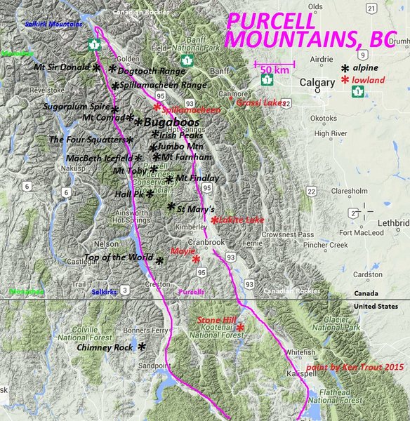
PURCELL MOUNTAINS
The Purcells are a mountain range that forms the east side of the Columbia Mountains. The high summits of the Purcells tend to be on the west side of the range above the Purcell Trench near the Selkirks, and approaches are often up long, drier canyons on the east slopes. The steeper, shorter western slopes bear the brunt of storms and are more heavily overgrown.
The Purcell Mountains were named after Goodwin Purcell, the expedition sponsor for the Palliser Expedition from 1857 to 1860. The Palliser Expedition crossed the Rockies and traversed into the Purcell Mountains when few trails and roads penetrated into the rugged, isolated region of the east Kootenay.
Access
Roads
Purcell Wilderness Conservancy
GRAND TRAVERSES
Rogers Pass to the Bugaboos 130 km
Purcells on Foot 280 km
Purcells by Ski 387 km
BOUNDARIES
East: The east side of the Purcells is formed entirely by the Rocky Mountain Trench that separates them from the Rocky Mountains.
This is a huge “U-shaped” glacier-hewn valley that winds north/south through the entire length of eastern BC. In the East Kootenay, this lowland valley channels both major rivers of the area, the Columbia and Kootenay rivers. At the town of Canal Flats, both major rivers pass each other within 1 km and flow in opposite directions. Early in the century and again in the 1980s, engineers invented a scheme to build a short canal to divert the Kootenay River to flow north into the Columbia River (to take advantage of all the hydroelectric dams on the Columbia). After exhaustive study and heated protests, the plans were shelved.
The widest section of the Rocky Mountain Trench is between Kimberley and Fort Steele, where it spreads 27km. The narrowest part is the Windermere/Columbia Valley section, where it spreads under 14km wide.
Columbia River. It flows north from glacier-fed Columbia Lake to Windermere Lake. This river collects water from all the northern Purcell tributaries and continues north past Bolden. The extensive glaciation of the Purcell Mountains contributes volumes of glacial silt to the river, accounting for its scenic turquoise colour. In the Rocky Mountain Trench, the Columbia River flows in a naturally sprawling wide wetland through the Columbia Valley Wetlands. North of Golden at Donald, just after the Big Bend of the Columbia (where the river turns from running NW to going south towards the city of Revelstoke), is Mica Dam, the first of the hydroelectric dams on the Columbia. It backs up as the Kinbasket Reservoir.
Kootenay River. It begins its long journey from the mountains east of Canal Flats. As it flows south into the lowlands, it collects all the water from the Height-of-the-Rockies, Purcells, Rockies and the Elk Valley. The Kootenay River widens and slows in the Rocky Mountain Trench, but stays as a tight meandering channel. Near the town of Wardner, the Libby Dam controls the river in the Koocanusa Reservoir (a combination of Kootenay-Canada-USA) as it meanders south into Montana, United States.
It then begins its big bend to include the Purcells completely.
South and West: As the Kootenay River turns north again into Canada near Creston and flows into the Creston Valley Management Area. Then the river continues north into Kootenay Lake of the West Kootenay. Kootenay Lake is 110 km long and empties via the West Arm past Nelson, BC to flow into the Columbia River at Castlegar. The Duncan River empties into the north end of Kootenay Lake. It forms the west boundary of the Purcells separating them from the Selkirk Mountains.
GEOLOGY
They are much older than the Rockies, at least 1,500 million years old and began uplifting when the only life on earth was simple single-cell plants and animals. The northern section of the Purcell Range is composed mostly of heavily eroded and fractured sedimentary rock but the sediment layers are not as thickly bedded as those of the Rockies.
Some granite intrusions and other metamorphic rocks protrude into these mountains. The most famous climbing is on the high granite summits of the Conrad, Vowell and Bugaboo Groups and the Bugaboos are world famous.
The biggest uplift of metamorphic rocks is in the Mount Farnham area.
At the end of the last ice age, a huge glacial meltwater lake combined the Kootenay and Columbia rivers, depositing thick sediments along its vast banks. These soil rich but rocky banks provide much of the land for winter wildlife range and human settlement. In several places along the “Trench”, spires of alluvium hoodoos stand as picturesque vertical remnants of erosion by water the best example of East Kootenay hoodoos is just north of the Dutch Creek bridge, south of Fairmont. These towers of partially cemented sand and gravel stand 120m (400’) high beside the highway.
RANGES
The Purcells can be divided into two regions, the northern and southern areas. Both have distinct mountain features, notable for hikers.
Northern Purcells have several summits over 3000m (10,000 ft.), with steep-sided valleys. Climbing most northern Purcell peaks requires technical skills, The hiking trails follow scenic valleys to alpine ridges, turquoise lakes, flower-covered meadows ad near many active glaciers.
Southern Purcells are not as high, nor as rugged. Hiking and climbing to the summits is more accessible and many day hikes lead to impressive mountaintops over 2400m (8000 ft.). Subalpine lakes, diverse forest habitats and open basins are the main features, with a few tiny glaciers crouching in the shaded mountain valleys.
Purcell Mountains in the USA. Primarily a Canadian range, the Purcells extend south across the border into Idaho and Montana. The range is located northeast of Bonners Ferry and is bounded by US-95 and US-1 on the west and the Kootenai River and US-2 to the south. The highest point in the Idaho section of the Purcells is an unnamed peak that reaches 6,779 feet.
The range was completely inundated by Pleistocene glaciers, which scraped away much of the range’s Precambrian rock. The Moyie River Canyon splits the Idaho section of the Purcell Mountains; it is the most spectacular geologic feature in the range.
The Purcells are managed by the Panhandle National Forest, which primarily manages the range for timber harvesting. As a result, the range has an extensive road system and a very small and broken trail system. Only short day hikes are available for hikers. The few mountain lakes are reached by roads. Climbing opportunities are limited to non-technical Class 1 and Class 2 accents.
ROCKY MOUNTAINS
On the east side of the Rocky Mountain Trench, the Rockies are the youngest of the interior mountains. The Rockies were formed during a time when dinosaurs walked on earth, about 100 million years ago. Laid in shallow seas of coral, the mountains are comprised mainly of white massive limestone layers. They contain many fossil beds and deeply–cut creeks. Sedimentary and metamorphic rocks also form the Rockies.
On the western side of the Rockies, several high peaks rise from 2400 to 3000m (8000-10,000 ft.). Hikers may reach many of these prominent summits on a day trip. They require no special climbing knowledge or equipment, just stamina and occasional rock scrambling skills.
