
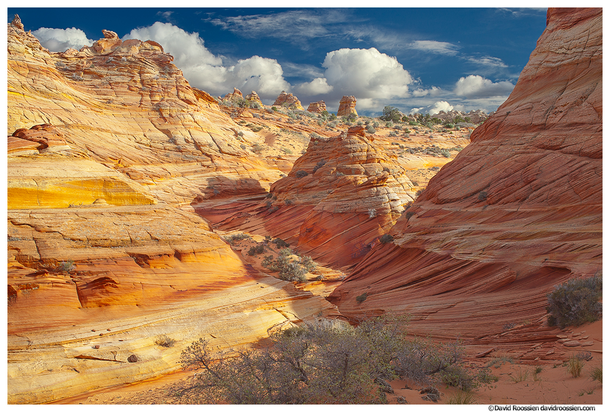
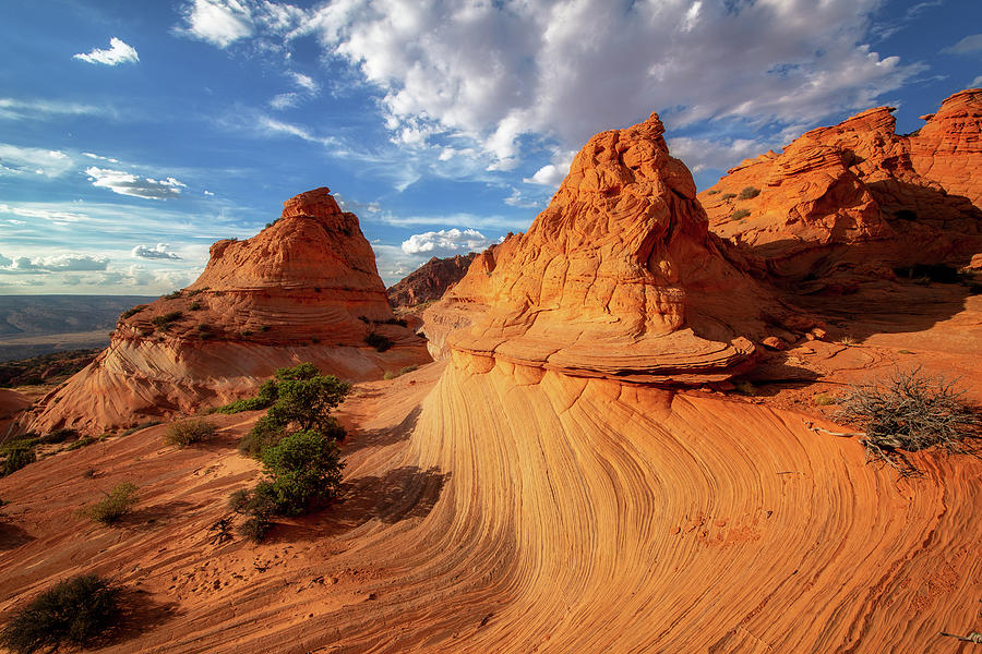
Coyote Buttes is situated in the Colorado Plateau, which spans across the states of Arizona, Utah, Colorado, and New Mexico. This remarkable sandstone formation consists of undulating and contoured rock layers, giving the appearance of a frozen, swirling wave.
Multicoloured, eroded rock formations dominate most of southeast Utah, though particularly outstanding is the desert on either side of the Paria River, beneath the Vermilion Cliffs. It is seen along the Cottonwood Canyon Road or at the Paria Rimrocks. All the formations are contained within the Paria Canyon-Vermilion Cliffs Wilderness, of which the majority (the Arizona section) is also part of Vermilion Cliffs National Monument. Here the land is much sandier and barren.
All can be visited free of charge and with no access restrictions except the Paria Canyon system and Coyote Buttes, an eight-mile section spanning the UT/AZ border. It was unknown before the mid-1990s but is popular because of just one formation, The Wave, a small ravine between eroded sandstone domes formed of amazingly beautiful rocks containing thin, swirling strata. Because the BLM considers the formations particularly delicate, Coyote Buttes is subject to fees, and entry limitations, with visitors having to apply in advance for daily permits.
Coyote Buttes was first publicized in Germany, in magazine articles and a movie (‘Faszination Natur’ by Gogol Lobmayr, 1995), and for the following few years was visited only by a few Europeans.
Coyote Buttes are the southern portion of the Coxcomb Ridge, a 40-mile-long escarpment that parallels much of Cottonwood Canyon Road and is crossed by US89 and ALT-US 89 south of the Vermillion Cliffs in Arizona.
The area is accessed on House Rock Valley Road (HRV Road). It is unpaved and minimally maintained. Most of the time, two-wheel-drive, high-clearance vehicles can drive the road. However, four-wheel-drive, high-clearance vehicles are necessary when the road is wet. During the rainy season and the winter, the road may become impassable for all vehicles, even those with four-wheel drive.
The BLM divides Coyote Buttes into two equal-sized sections, North and South.
Use topographical maps if possible. Buttes are marked with elevations that serve as waypoints.
NORTH COYOTE BUTTES
The trailhead for the North section is 8.5 miles down HRV road, the same as the Wire Pass entrance to the Buckskin Gulch slot canyon.
This contains the Wave and other famous sites and extends from Wire Pass about 4 miles south (2 miles in Utah and 2 miles in Arizona), while the southern half stretches a further 4 miles. The only other easily reached starting point for the North is The Notch, 2 miles from Wire Pass, where a trail climbs a pass in the cliffs and leads to the south end of the north section.
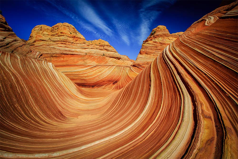
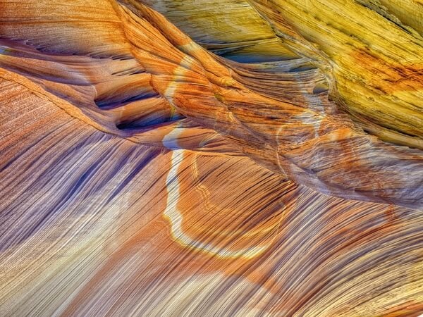
The Wave. Coyote Buttes North is famous for “The Wave,” one of the world’s most iconic and sought-after geological formations. “The Wave” is characterized by its undulating, swirling sandstone layers that resemble a frozen wave. The vibrant colours and intricate patterns make it a popular destination for photographers and hikers.
Top Rock. This viewpoint offers visitors a panoramic view of the Coyote Buttes North area and is an excellent spot to take in the surrounding landscape. This is where I get lost when I go to CB without a permit. It is a great place to spend the day where the rangers don’t go. It has lovely yellow rock full of red streaks, formations and pine trees

Top Rock Attractions: Has three spectacular features (if you can find them):
Alcove or Wind Room. It is a depression with a large sand dune in the middle. The rock lining the walls has amazing features. I have seen this when the SW wall was not covered in sand. 
Coyote Buttes Arches (two small arches that are very difficult to find – no hints here)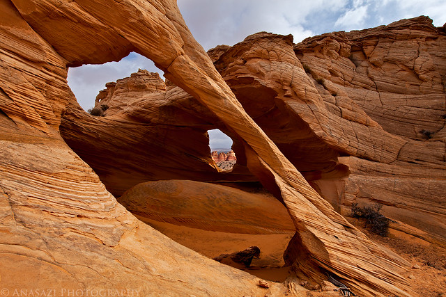
Melody Arch – an arch on the west edge of Top Rock

“The Boneyard”: This area features a concentration of weathered and eroded sandstone structures, creating a surreal and otherworldly landscape reminiscent of a prehistoric graveyard.
Walk to the far south end of Top Rock and get off Top Rock down the steep narrow ledge formations to the west. The Notch is to the west. Turn north across great swirls of rock to reach the Wave II.
Wave II – Spectacular formation under the west side of Top Rock south of the Wave.

Sand Cove
Dinosaur trackway. On the way to the Wave. A 0.75-acre (3,000 m2) site with more than 1,000 densely packed dinosaur footprints dating from 190 million years ago. Tracks of three genera of Eubrontes, Anchisauripus and Grallator are present along with a Sauropodomorph that has not been identified
The Big Mac – a piled bunch of flattened rocks just like the hamburger. I have never seen this but it must be towards the south end of Top Rock and to the east.
The Notch. An alternative route to the Wave. Rough trail.
Maze Petroglyph Panel in the entire area
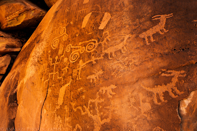
North Teepees – petroglyph panel to the east at the base of small butte 5434T 1656
South Teepees – can spend almost a whole day exploring the area to the east of the main CB ridge. Access from the end of Top Rock to the east near The Big Mac or from the South Buttes. Cowboy signature and petroglyph panels at the south end of South Teepee.

SOUTH COYOTE BUTTES
Coyote Buttes South is not The Wave. There are no trails. Explore in relative solitude, as few go here. The entrance is 21 miles south on HRV Road. It is harder to reach due to the sand.
Attractions include Top Rock Spring, arches, a group of stripy mounds and the tepees of Cottonwood Cove.
ACCESS
1. Lone Tree Reservoir access. 26.4 km from Hw 89, accesses the very southern end of Coyote Buttes at Paw Hole. Turn east off HRVR for 320 m to the reservoir. A 2WD can drive for 1.6 km. Park and camp. Past here the road is very sandy and for 4WD only. If you are foolish enough to continue even in your 4WD, continue ESE uphill for 2.2 km ((total from HRVR). Turn left (north) at a T junction. After 1.5 km, you are just south of Paw Hole and a 200 m-long section of very deep sand, the worst sand trap in the entire Sand Hills. Gear down, rev up, go like hell, and don’t slow down until on firm ground. Continue east to the Poverty Ranch and then turn north towards the Cottonwood Cove area (camp, trailhead) by a 2.6-mile 4WD track starting from Lone Tree Reservoir on HRV Road.
a. An alternative route is by 2.5-3.5 mile, off-trail, cross-country hike from HRV Road, climbing over the main ridge. Roads leading to the permit area have deep sand and sharp rock. You must have a four-wheel-drive, high-clearance vehicle and experience driving in deep sand. Every year, groups get stuck and stranded.
2. Pine Tree Pockets (Pine) access. 32.7 km down HRVR from Hw 89 (15 km from 89A). Bowman Corral is at the junction. Head east on this well-graveled road toward the Pine Ranch. At 5 km, need 4WD and turn northeast onto Corral Valley Road that heads towards the Poverty Ranch (only a well and barn remain and there is not much to see). Bypass the ranch (deep sand, especially on the east) by staying to the left. Pass a corral to the pass, camping area and trailhead marked 1727m on Kelsey’s maps.
Big Brain/Cauliflower Rocks (BB&CR)
The Teepees: One of the standout features in Coyote Buttes South is “The Teepees.” These tall, slender, and pointed rock formations resemble teepees, with alternating bands of colourful sandstone. They make for a captivating and photogenic subject.
Cottonwood Cove: Located within Coyote Buttes South, Cottonwood Cove offers a serene and picturesque setting with its lush vegetation, making it a beautiful contrast to the stark desert landscape around it.
The Southern Wave – on the way to the spring.
The Nautilus: This formation resembles a giant nautilus shell, with spiralling layers of sandstone. It’s a unique and fascinating sight for those exploring Coyote Buttes South.
Cottonwood Spring and Walter Hamblin’s cabin site. Continue onto Top Rock.
Top Rock Spring


Walk the ridgeline of Buttes to Paw Hole. See the Cottonwood Cove Viewpoint, Tiny Northwest Cove, Tiny Cove and Paw Hole.
Paw Hole: This area contains a variety of intriguing sandstone formations, including arches, hoodoos, and twisted rock columns. It’s a fantastic place for exploration and photography.
White Pocket A great place to explore all day. The best access is from Poverty Ranch. Near are Pottery Butte and Hole in the Rock (a large arch).


Permits
Permits are required to enter North or South Coyote Buttes and are allocated by online lotteries. They cost $7 per person plus a $9 application fee. A daily maximum of 64 people are permitted to visit Coyote Buttes North – 48 by online lottery and 16 and/or 4 groups (whichever comes first) in the daily lottery. The south has a maximum of 20 people. Group size is limited to six, and they must stay together for the entire hike.
There are two types: Daily and Advanced
The Daily Lottery is for people in the local area and is held two days before the intended visit; there are 16 places for the north (The Wave) and 10 for the south. It is available on Recreation.gov in your browser or on the Recreation.gov app.
The Advanced Lottery is held four months before and is more commonly used as it allows 48 people and/or 12 groups (whichever comes first) for the North and 10 for the South.
The application is the same for both regions. The lottery is run on the first of the next month at 9:00 am. You must submit payment by the 15th of the month or forfeit the permit. Each individual may submit only one application per lottery. Multiple applications to the lottery by the same individual will be cancelled without a refund.
All permits are always greatly oversubscribed, sometimes by a factor of a hundred or more. Successful applicants receive a copy of the access regulations and, for North Coyote Buttes, a route description, a topographic route map, a photo guide and GPS coordinates along the suggested 3.2-mile route to the Wave, as there is no trail. Permits are required for dogs – $7.
There are no developed trails or facilities. No overnight camping is permitted anywhere; there is a campsite on House Rock Valley Road at the Wire Pass Trailhead.
There is no age limit to apply, but there must be an adult. The permit will be mailed out 4 to 6 weeks following the lottery by Vermilion Cliffs National Monument. Selling or transferring permits is prohibited, will invalidate the permit, and may result in a citation.
ALL Permits are non-refundable and non-transferable.
HOW WERE COYOTE BUTTES FORMED?
Originally, Jurassic sand dunes from 200-145 million years ago consisted of intersecting U-shaped troughs caused by the sand dunes being repeatedly deposited and partly blown away, with more and more layers being deposited on top. Later deposits buried the sands deep underground and compressed them into solid sandstone over millions of years. The covering layers have been eroded by wind and weather, exposing what is seen today. Dinosaur tracks have been found in the Jurassic sandstone.
Cross-bedded sediments form in granular sediments, especially sandstone deposited at an angle rather than horizontally, producing layers that are tilted or inclined. The series of layers forms on the lee side of a wind-formed dune. Winds blow sediment along the ground until it accumulates on the windward side. As it builds, some sediment falls over the end on the leeward side. Repeated avalanches will eventually form the sedimentary structure known as cross-bedding. The sediment is deposited at an angle to the base and top of the bed rather than deposited horizontally and deformed later. They can be curved or scoop-shaped or merge tangentially with the underlying beds.
The real colour depends on the time of the day and is saturated early, late and after rain. These are sandstones from Jurassic aeolian (wind-formed) processes that have become lithified. The colour is mostly from iron.
The layering is due to small-scale separation between layers of material of different sizes and densities. As more sediment piles on top, the weight causes the underlying sediment to cement together and form cross-beds.
Sedimentary Deposition: Coyote Buttes are primarily composed of sedimentary rocks, with sandstone being the dominant rock type. These sedimentary rocks originated from the accumulation of sand, silt, and clay particles over an immense period. The sediments were deposited in ancient environments such as rivers, lakes, and deserts.
Lithification: Over millions of years, the layers of sediment became buried under additional layers of sediment. The tremendous pressure from the overlying material, coupled with the infiltration of mineral-rich groundwater, led to a process called lithification. Lithification involves the transformation of loose sediment into solid rock. In the case of Coyote Buttes, the primary lithified rock is sandstone.
Erosion and Weathering: Once the sedimentary rocks were formed, the landscape began to experience a variety of erosional forces, including wind, water, and ice. These natural elements started to shape and sculpt the rock layers, exposing the intricate patterns and unique formations. Erosion and weathering acted differently on the various types of sedimentary rock, creating a wide range of features, from the smooth, swirling contours of “The Wave” to the jagged cliffs of the surrounding area.
Differential Erosion: One of the most important factors in creating the distinctive features of Coyote Buttes is differential erosion. This occurs because the sandstone layers are not uniformly hard; they have varying levels of resistance to erosion. Softer layers erode more quickly, while harder layers remain more resilient. This leads to the creation of fascinating formations such as the undulating shapes of The Wave and the slot canyons that permeate the region.
Several Areas of BB&CR – Big Sink, Middle Reservoir, Twin Tank, Cowboy Hat (an odd structure),
Petroglyphs and cowboy signatures at Little Knoll (2-part panel on the north),
Geological Uplift: The uplift of the Colorado Plateau, where Coyote Buttes is located, played a crucial role in exposing these sedimentary rocks to the forces of erosion. Over millions of years, tectonic forces lifted the region, causing the Colorado Plateau to rise. This uplift allowed the erosional processes to work on the rocks, gradually revealing the intricate layers and formations.
Colouring and Minerals: The vibrant colours seen in the sandstone of Coyote Buttes are a result of mineral deposits within the rock layers. Iron oxides (such as hematite and goethite) create red and orange hues, while other minerals contribute to the range of colours, including purples, pinks, and yellows.
In summary, the geological landscape of Coyote Buttes is the product of a fascinating interplay of geological processes over an immensely long period. The unique patterns, colours, and formations in the sandstone result from sediment deposition, lithification, erosion, differential erosion, geological uplift, and mineral content. This combination of factors has created one of the most visually stunning and geologically significant landscapes in the world.
In addition to The Wave, Coyote Buttes offers a range of other stunning rock formations, hiking opportunities, and photogenic spots – Coyote Buttes South, White Pocket, and Buckskin Gulch, each offering its unique geological wonders and natural beauty.
