
AUSTRALIA – NEW SOUTH WALES – CENTRAL AND WESTERN (Wagga Wagga)
Day 57 Wed Nov 15
I started the 350 km drive to Albury NSW late. I got Google Mapped as it took a very direct route, first on a winding road, the Bairnsdale-Dargo Road C601 and after Dargo a narrow paved road that climbed up slowly with a lot of construction. I groaned when I hit gravel through Alpine National Park, basically on the top of the world here – the Dargo High Plains road. Of variable quality, it lasted 48 km, changed to paved and finally joined the Great Alpine Highway which now looked like a freeway. It descended on a very winding road for many km until Harrietville and finally levelled out at Bright, a gorgeous town with big trees lining the highway.
ALBURY-WODONGA
Albury is very pretty with buildings from the 1850s and a lot of Art Deco. A large cenotaph is on top of the big hill to the west giving good views of the city.
Albury Botanic Gardens. Small but lovely – roses, children’s garden, palms, lawns and some large trees: sweet gum, Kauri pine, bunya bunya pine, lemon scented gum and Atlas cedar. Free
Murray Art Museum. Not a terrible lot of interest. A photograph exhibit (along with many artifacts he had collected) showed poor compostion and light selection. Free
Albury Library Museum. A gallery in the public library with exhibits on the Dr Cleaver family, photos of the city, 50 years of rock photography, KLM plane almost crash, Margaret Court, Europeans and aboriginals. Free
128 km to Wagga Wagga.
ON Wayside in the town of Gerogery, very nice especially when the lights came on over my covered picnic table. I stopped early as all the sites in Wagga were closed and I had a lot of catching up to do, especially my Nauru visa (finally paid for using Wise where I found a CA$30).
Mileage: 339 km
Day 58 Thur Nov 16
WAGGA WAGGA
Museum of the Riverina. In the old city council chambers (lovingly restored in the museum), there are exhibits on feral dogs and cats, and old photos demonstrating land use climate change, and the effect of agriculture. There were also many astrophotography photos, apparently from some competition (they were very good). Free
Wagga Wagga Botanic Gardens. Possibly the least inspiring BG I have seen – mostly brownish grass, trees, and a rose garden. Free
RAAF Wagga Heritage Centre. 9 km east of Wagga, this is on an airforce base (and staffed by soldiers) with many photos and vignettes of pilots (often with their donated gear). Profile of the Beaufighters, pilots flying a specific plane. Female soldiers and WWII history along with all the other wars Australia has gotten involved in with the US. Technical school. There are 5 planes outside – one bomber (the Canberra built in Australia) and four fighters. Free
Dog on the Tuckerbox, Gundagai. A 1932 monument at a roadside store/restaurant, it is a nondescript black dog sitting on a green tuckerbox (lunchbox) on a double stone plinth in the middle of a hexagonal pool. The inscription says “PIONEER MONUMENT GUNDAGAI” “EARTH’S SELF UPHOLDS THIS MONUMENT TO CONQUERERS WHO WON HER WHEN WOOING WAS DANGEROUS AND NOW ARE GATHERED UNTO HER AGE”
The story goes: In the 1850s, Bill the Bullocky, a teamster on the road to Gundagai was crossing 9-Mile Creek with his bullock team and wagon and became hopelessly stuck. On trying to pull the wagon out, the wagon yoke broke. To top it off, his dog was “on strike” sitting on his tucker box. The other bullockies thought the incident was a great joke. Bowyang Yorke penned a poem about the incident in 1857 and the story spread. A song was written in 1937 and became very popular. (I personally don’t get the joke – only Australians do?)
3000 people attended the unveiling of the small monument and government ministers attended the 50th and 75th anniversary of the original unveling (plaques attest to this). Throw money into the pond for good luck with the proceeds going to the hospital.
The drive here was throgh endless what field and in the rolling hills, pasture. I think this is one of the prettiest parts of Australia with all the golden grass and wheat, individual trees on a hilly landscape.
ON Wayside between Wagga Wagga and Canberra. The black flies are a menace.
Mileage: 200 km 8844
GO TO CANBERRA
==============================================================
RETURN FROM CANBERRA AND NSW INLAND
AUSTRALIA – NEW SOUTH WALES – EASTERN (Sydney, Newcastle)
Murramarang NP. Mt Agony.
ON Ulladulla Marina area. Nice covered tables but very bright lights at night. No bathroom.
Mileage:
Day 61 Sun Nov 19
I continued my drive north towards Sydney.
JERVIS BAY TERRITORY
Booderee NP. On Jervis Bay and St Georges Basin, it is mostly about the beach. The inland is scrub forest. Contains Jervis Bay Village, Booderee Botanical Gardens, several short walks (St Georges Head, Cape St George, Cave Beach), and three campgrounds. $15
Hyams Beach. A long white sand beach on Jervis Bay, it runs from Booderae NP to Jervis Bay NP. Several small rocky headlands. On a windy day, there was fair surf. Very popular and parking is almost impossible.
Jervis Bay NP. This has 2 inland sections (mostly scrub), and this short section is over 1 km long along the ocean. There is a nice forest with big gum trees,
Greenfield Beach. On Jervis Bay in Jervis Bay NP (and separated from Hyams Beach by 1.5 km of coast Jervis Bay NP – 15-minute trail), it is a 10 km drive through the town of Vicentia. It is deep white sand, about 200 m long, and a lovely day area with many tables.
Meroogal, Nowra. Built in 1886, for the Thorburn family whose 4 generations of descendants (the Macgregors) lived in it until 1985, it is a two-story Victorian house with verandahs, original hardwood floors, a servants wing and many mementoes of the family. It remains in good condition with some of the original furniture. The property is much smaller than the original and the gardens are 1/10th the size of the original. Free
Berry. Small Town
Nan Tien Temple, Berkeley. A Buddhist temple dedicated to Avalakutesvaia Bodhisattva. Originally male, when Buddhism arrived in China, she became female. Has 16 arms each holding a weapon and is backed by the 1000 arms crest. The temple site also has a large 7-story pagoda.
WOLLONGONG
Breakwater Battery, Port Kembla. There are two gun placements (batteries) overlooking the ocean. It is near the large breakwater. An art installation of many small white “pyramids” is between the two batteries.
Illawarra Museum. In the old post office, this is a history museum for Wollongong and Illawarra. It has a classroom (desks sit 2 per desk), a magneto telephone, many historical photos of Wollongong and Illawara, many old artifacts, blacksmiths, old carriages (with plastic horses), laundry, kitchen, a homestead house, a bedroom and sitting room upstairs. Free
Wollongong Art Gallery. In the old city council chambers, there are 4 stories of local art, watercolours and a wide assortment of techniques. There is a good Holocaust exhibit with vignettes of many of the people who helped Jews escape. I got into a discussion with the curator of this about Israel and Palestine.
Science Space. I dislike these as they are so kid-orientated. I arrived 20 minutes before closing and the young woman at the desk let me in without paying. True to form, there was little here of interest to adults (except maybe a video on the space station). $16, reduced $14 but free.
Wollongong Botanic Garden. Very large, the north end is mostly a large area of grass and some big trees. Two creeks run down the center producing a lovely temperate rainforest. Other gardens are succulent, and arid, with palms, many beds of bushes and flowers with a fairly large pond. Very nice. Free
Wollongong Breakwater Lighthouse. Built in 1937, it is 25 m tall and has always been automated. Sitting on Flagstaff Hill at a sharp point, the water below is a boiling mass over the rocks. Made of reinforced concrete, it is a lovely Art Deco design with arches at the bottom, narrow vertical ribs extending most of the length, and a geometric design on the band below the light.
Several people insist on feeding seagulls with a hundred frantic birds. The lady next to my car was feeding them with the birds shitting all over my car. I told her to stop feeding the birds bread. “it’s not bread, it’s chips”!!!!!
ON In the lovely lot just below the lighthouse. I had dinner in the lee of the hill out of the strong wind.
Mileage: 9512
Day 62 Mon Nov 20
Sea Cliff Bridge, Clifton. On the seaside road on the way to Sydney, this is a 605 m-long bridge built on piers separated from the steep rock wall to avoid rock falls. It was built over a previous coal colliery and rocky shore of the ocean in 2004-5 using 60,000 tons of rock to build the sea level access and 11,000 cubic metres of cement. The piers are protected from corrosion using an impressed electrical current. Many people park and walk the bridge. It is 21 km north of Wollongong and quite out of the way.
CAMPBELLTOWN
St John the Evangelist Catholic Church, Campbelltown. Built in 1836, this all-brick church has a steep A-frame-like roof, nice stained glass on the sides and a rose window.
The Australian Botanic Garden Mount Annan. A huge garden with only Australian plants is seen by driving on a one-way narrow 30km/hr road. See the Woodland garden, plant bank and Herbarium (many greenhouses), bottlebrush garden, wattle garden, banksia garden, and red gum gardens, each with special plantings. Each garden has a large parking area and picnic shelters. Several paved paths are for walking and cycling. Free
Rotary Observatory, Campbelltown. These are two tiny domes on a small hill surrounded by a park-like setting in a residential neighbourhood. Owned by the University of Western Sydney, they were built in 2000 for the Sydney Olympics. There is no information and they couldn’t be visited. One has the label “Laser and Illumination Lab”.
Mount Gilead Mill, Gilead: The windmill at the Mt Gilead property on Appin Road was built by Thomas Rose in 1836. The mill tower, which is built from sandstone quarried on the property, is 60 feet in height, comprises four stories, and is reputed to have contained the finest millstones in the colony. No metal was used in its construction and all the moving parts were fashioned from ironbark grown on the property. The tapering stone tower was topped by a moveable cap made of wood (as the sails had to be always facing into the wind, the moveable cap carried the sails and driving shaft). A stone wall surrounded the windmill, to protect animals from touching the rotating sails.
Mount Gilead is the last remaining tower mill in New South Wales.
Camden Museum of Aviation, Harrington Park. Not open on Mondays
Australian Aviation Museum, Bankstown. Permanently closed.
WEST OF SYDNEY
Lakemba Mosque. A large rectangle covered in cream brick with many arches, a single minaret and a green dome. Inside is a gaudy blue with calligraphy in the dome and one wall. Unusually, the mihrab is in a corner, covered in tiles with a stair minbar.
Parramatta Hospital Archaeological Site. Vestiges of the Past. Initially a tent hospital in 1790, the Parramatta District Hospital was built in 1818 as a colonial hospital, a 2-story building with 4 wards (men and women were separated). Each ward was 30 m X 6 m with 2.4 m high ceilings and was described as overcrowded, dark and damp with dysentery common. Going here was described as a death sentence. Many died. It served convicts who built the community of Rose Hill (name later changed to Parramatta).
From 1848-1902, it was the Parramatta District Hospital (with no convicts), from 1896-1901, the Sulman Power Cottage and in the 1950s, Jeffrie House.
The site is a large glass and metal frame rectangle with the foundation walls exposed and three glass cases with archaeological findings.
Woolpack Hotel. Parramatta. Originating in 1796, it is the oldest continuously operating bar in Australia (one in Hobart might argue). Three stories on the corner and one story on the sides. Now has a casino (slot machines), a nice bar and a restaurant. Historic photos in the dining room – one says “The Birthplace of Bowls in New South Wales”. Supposedly there are rooms but I didn’t ask.
Elizabeth Farm, Rosehill. Dating from 1793, it is the oldest surviving homestead in Australia. Today there is a stone 2-story house (painted yellow) with furniture as period as possible, an outside kitchen, and a work shed. The gardens are lovely. On either side is the Elizabeth Reserve, a park with grass and trees.
Gallipoli Mosque, Auburn. A grand mosque with two minarets and a “wedding cake” design in 5 layers ascending to the 8 small silver domes and finally a large silver dome. Inside is a riot of calligraphy and design lining the dome (red/green stained glass and round white stars in red circles), walls and columns. A balcony goes all the way around. The minbar is very tall. It has a youth centre on the side.
Kokoda Track Memorial Walkway. This is a gorgeous tribute built in 1996. Large marble storyboards, each relating a stage of battle on the tract, line a cement walkway in a very nice long park bordering a river. In the center is a semicircle of three marble walls with incised pictures. I read about 10 but still find it very confusing as there were so many retreats and advances by both sides. Basically, the Japanese were using the track (starting in Kokoda) to capture Port Moresby with the Australians eventually preventing them from doing so.
I saw the Kokoda Tract cemetery outside Port Moresby (read about the battles there).
ON In the lovely parking area of the Kokoda Track Memorial. The Rotary has built a lovely covered area with 6 picnic tables, a BBQ, bathrooms and an Education Centre. This may have been the nicest overnight spot in all of Australia. No black flies.
Day 63 Tue Nov 21
I continued my drive about to see all the NM sites in Sydney proper.
SYDNEY (pop 5,297,089) is the capital city of New South Wales, and the most populous city in Australia. Located on Australia’s east coast, the metropolis surrounds Sydney Harbour and extends about 70 km (43.5 mi) towards the Blue Mountains to the west, Ku-ring-gai Chase National Park, Marramarra National Park and the Hawkesbury River to the north and north-west, and the Royal National Park and Macarthur to the south and south-west. Greater Sydney consists of 658 suburbs, spread across 33 local government areas. The city is home to approximately 66% of the state’s population.
Aboriginal Australians have inhabited the Greater Sydney region for at least 30,000 years, and Aboriginal engravings and cultural sites are common. During his first Pacific voyage in 1770, James Cook charted the eastern coast of Australia, making landfall at Botany Bay. In 1788, the First Fleet of convicts, founded Sydney as a British penal colony, the first European settlement in Australia. After World War II, Sydney experienced mass migration and by 2021 over 40 percent of the population was born overseas. Foreign countries of birth with the greatest representation are mainland China, India, the United Kingdom, Vietnam and the Philippines.
Despite being one of the most expensive cities in the world, Sydney frequently ranks in the top ten most liveable cities. Ranked eleventh in the world for economic opportunity, Sydney has an advanced market economy with strengths in finance, manufacturing and tourism. Established in 1850, the University of Sydney was Australia’s first university and is regarded as one of the world’s leading universities.
Sydney has hosted major international sporting events such as the 2000 Summer Olympics. The city is among the top fifteen most-visited, with millions of tourists coming each year to see the city’s landmarks. The city has over 1,000,000 ha (2,500,000 acres) of nature reserves and parks, and its notable natural features include Sydney Harbour and Royal National Park. The Sydney Harbour Bridge and the World Heritage-listed Sydney Opera House are major tourist attractions. Central Station is the hub of Sydney’s rail network, and the main passenger airport serving the city is Kingsford Smith Airport, one of the world’s oldest continually operating airports.
M8 Motorway Tunnel. The WestConnex M8 is a 9-kilometre (5.6 mi) tolled motorway that links the M5 Motorway at Kingsgrove to the St Peters Interchange at St Peters. I made a wrong turn before the Iron Cove Bridge inside the tunnel and ended up driving its entire length and then back to the bridge (all tolls).
Iron Cove Bridge is a heritage-listed road bridge that carries Victoria Road (A40) across Iron Cove, between the Sydney suburbs of Drummoyne and Rozelle. Iron Cove is an arm of Sydney Harbour (Port Jackson).
The first bridge was completed in 1882 and replaced in 1955. All nine of the 1882 bridge’s pairs of girders are still in use in three bridges on country roads in the Forbes district. It is a steel truss bridge 461.26 metres long and has four lanes and tram tracks in the centre. A parallel box girder bridge was added in 2011. It has a pedestrian footpath.
The road leading here was the M4 tunnel. I missed the only turn and took it 12 km to its end and then returned the same way to go over this bridge.
Sydney Fish Market. This is unusual in that all the seafood is sold from individual stores around the parking area and in the main building. There are several restaurants and a vegetable, bread and wine store.
James Craig. A three-masted tall ship built in England in 1874. It sailed around Cape Horn 23 times and around the world 13 times. It stored copra from 1911-18 and coal till 1923 and then was abandoned for 40 years. Restoration was finished in 2000 at a cost of $3 million.
It was closed for renos but they let me in for $5 and I had a self-guided tour. The below decks are basically empty except for the bunks, office, kitchen and salon at the back. They were making a new sail and maybe there is more to see when it normally opens.
Australian National Maritime Museum / HMAS Onslow. I didn’t go in $25, 20 reduced. The Onslow is a submarine in the harbour.
Harbourside Shopping Centre was a shopping centre in Darling Harbour built in 1988 but closed in 2022 preceding its demolition. The site will be redeveloped for a mixed-use tower and retail complex.
Dr Chau Chak Wing Building (building 8). Part of the UTS Business School, it has a great shape accented by all the window frames that jut out about a foot from the facade. There is decorative brick, curved corners and a two-story projecting section (all wavy lines) on floors 5 and six.
One Central Park. Architectural Delight. is a mixed-use dual high-rise building with two residential apartment towers, and a six-level retail shopping centre at the base of the towers. “What we want is to create a village that people can work and play in. The West Tower was completed in 2013 and the first residents moved in, then Park Lane, The Mark, and the Sky at One Central Park (Penthouses). The 1,300 apartments had an average price of AUD $770,000 per apartment.
One Central Park has 4 below-ground levels, 34 above-ground floors and 625 car parking spaces. There are 23 vertical hanging gardens (35,000 green wall plants, flowers and vines – 350 different species) 50 metres high in planter boxes with no soil, each with its own irrigation system,
A cantilevered heliostat is suspended from the 28th floor and reflects light to the gardens using motorized mirrors. It has an LED light display
It has its own low-carbon natural gas power plant and a membrane bioreactor to recycle water that comes from rainwater, stormwater, groundwater, and sewage. There is a private gymnasium and a pool.
Sydney Central Station. The old part is a lovely rough stone extending for an entire block. A new part has a high clock tower.
Jewish Museum. Has a great timeline of Jewish history (they were expelled from virtually every country they were in – England 1290, France 1306, Germany 1460-90 and Spain 1492), many religious artifacts, an explanation of holidays, Jewish life,. the role of Jews in all the Australian wars, and a large section on the Holocaust. $20, reduced 15
SCG Museum. Cricket museum that I didn’t see as I couldn’t find parking (and had little interest in).
Paddington Markets. Held on Saturdays from 10-4 in the area around two churches and in a schoolyard. Mostly handicrafts but some food.
Mary Immaculate Church. A large blocky church with two square bell towers. Inside there are 3 huge frescoes on each side. The Ways of the Cross are coloured bas-reliefs with very elaborate frames. The church is not left open but the lobby was so one can still have a good look.
Bondi Beach. The famous beach of Sydney is a half-kilometre of curving yellow sand. On a relatively cool day, it was still busy with many surfers, some swimming and many just sitting on the beach. Backed by a grassy slope.
Vaucluse House, Vaucluse. An 1801 country house that looks like a castle with crenellated roof lines and a 3-story new addition. In a very large park of grass and trees with an event restaurant and another house. Elaborate furnishings. Free
Macquarie Lighthouse, Vaucluse. Built in 1811, it is Australia’s oldest lighthouse. It is a lovely stone painted white with a nice black railing at the top deck. It sits on a building.
Elizabeth Bay House. Built in 1836, it was Sydney’s ultimate trophy home. With harbour views, sweeping staircases and spectacular landscaped gardens. It sits in the middle of a residential neighbourhood with virtually no grounds. Closed on a Tuesday.
I then had a drive about looking for a place to stay for the night. The Elizabeth Bay area is close to downtown with nothing.
ON When I was in Wollongong, I talked to a woman at the Breakwater Battery who told me about free parking next to a park in Enmore, a suburb of Sydney where several tents had been set up and with good metro access to downtown. Enmore is not small and I had no idea where it might be. I picked the largest park, saw the tents and waited for a parking spot.
Day 63 Wed Nov 22
I left at 8 to take the train from St Peter Station about 1.5 km from the park.
St Mary’s Cathedral. A wonderful huge church of yellow stone, two bell towers, a large tower over the cross, and many spires. Inside there are multilobed columns, some lovely chapels, elaborate stained glass on the sides, three rose windows, and elaborate carved stone altars. The Ways of the Cross are huge paintings.
Shakespeare Memorial. In the middle of a road, the bronze of Shakespeare (1564-1616) sits on top of a double plinth of marble with four of his characters standing around the base.
Royal Botanical Garden. I entered at the Morshead Fountain gate and walked by the palace and palace rose garden. Has herb, succulent, oriental, tropical, South African, Sydney fernery, and Australian Nature Rockery gardens. Government House blocks some access to the opera house.
SYDNEY OPERA HOUSE WHS. Seen by tour booked through their website (10:45 A$43). A marvel of architecture, all finished concrete, red granite floors and wood inside. Has six theatres, 4 small and two large. Start the tour at the Drama Theatre and watch a video of the construction issues. Then see the Concert theatre that holds 2500. Last see the Ballet/Opera theatre that holds 1500.
The roof is ceramic tile (mostly white and some tan) that never needs maintenance. There are no gutters and rain runs off to the ground and drains.
Circular Quay. This is the Malecon that encircles the end of the port – many restaurants on the left and 6 wharves on the right.
Museum of Contemporary Art. Young Australian artists, many photos from the 70s, Witness exhibition. Not much that I liked as is typical of contemporary art. Free
Rocks Discovery Museum. A small 2-story museum. The history of this part of Sydney. The coast was 15 km east 15-25,000 years ago, aboriginal history, the coming of the Europeans (archaeology), the port and docks. There were once 50 pubs on this street. Free
Fortune of War Pub. The oldest pub in Sydney from 1828. The original burned down and this was built in 1920. Many old photos, a U-shaped bar with a lowered ceiling over the bar for ads and alcohol, and old tiles. Cocktail lounge upstairs. Not sure if the hotel still exists.
Susannah Place. The terrace of four tiny houses has been home to more than 100 families over 150 years. Built by Irish immigrants in 1844, it has survived largely unchanged through the slum clearances and redevelopments and tells the stories of the working families who lived there. There are four tiny side-by-side, two-story homes dating from 1844. It is a museum open Fri-Sun seen only as a guided tour. Walk up several flights of stairs to get here.
Sydney Museum. Exhibits on the opera house (along with operas, ballets, theatre and dance), government house, set boxes, all the early ships and convicts. Free
Reserve Bank of Australia Museum. Shows a lot of currency and details all the security features of the current plastic bill. Free
Westfield Shopping Mall. Six floors of high-end stores. These high-end stores continue on the ground for a block or so around the mall.
Sydney Tower is the tallest structure in Sydney and the second-tallest observation tower in the Southern Hemisphere at 309 m (1,014 ft) above the Sydney central business district (CBD). It sits above the Westfield shopping centre. Construction began in 1975. Four sections of the tower are open to the public, three being occupied by Sydney Tower Dining. The observation deck, the Sydney Tower Eye, is located on level four 250 m (820 ft) above ground level. Skywalk is an open-air glass-floored platform encircling the Sydney Tower Eye 268 m and extends over the edge of the main structure of the deck.
The Sydney Tower Stair Challenge runs up 1,504 stairs. In 2018, the Skywalk was closed for five weeks following the suicide of a 21-year-old woman who removed her safety harness and leapt from the tower while on a tour. On top of the Westfield Mall. I didn’t go up.
Great Synagogue of Sydney. A three-story rather plain building with stained glass windows on the top floor. It holds the War Memorial Centre opened in 1955. There was a sign stating that they were not open to the public.
Australia Museum. First Nations, has many stuffed animals (the Tenac, a small rodent-looking animal has the smallest brain for its weight of any mammal and the mother can have a litter as big as 35, a record for mammals – 2 great records for an animal I have never heard of). 200 Treasures of the museum – some were interesting, others banal. Free
Art Museum of New South Wales. In a magnificent yellow stone building fronted by several columns, this is a very good, large art museum with a little bit of everything including a very large pre-1900 collection. There were two Emily Carr paintings with good write-ups by Canadians. Free
It was an 800 m walk back to St Edward station, a 20-minute train ride to St Peters and a 20-minute walk back to my car in Enmore.
I then had a drive about to see my last three sites in Sydney proper.
Grace Building is a Federation Skyscraper Gothic style that houses a bar, hotel, cafe and restaurant that opened in 1930. The building was of the Art Deco architectural style and had state-of-the-art innovations and facilities for the time.
Extensive renovation and restoration during the 1990s resulted in the return of many of the building’s original features, including light fittings, lifts, stairwells, high pressed-metal ceilings, marble floors, wide hallways, and elegant decorative ironwork. Since June 1997, it has operated as a luxury hotel known as “the Grace Sydney”.
With a soaring vertical emphasis and prominent “Gothic” corner tower, complete with flying buttresses, pointed windows and quatrefoils. Sheathed in glazed cream terra cotta and green details. The decoration is limited, in skyscraper fashion, to the summit and lower portion of the building. The street-level facade has been altered, but the facade above the awning remains intact.
The Grace Building is historically significant because of its association with the retail boom of the 1920s. It epitomizes the optimism and dynamism of that period as well as the subsequent economic collapse and Great Depression. It is architecturally significant as a skyscraper gothic style and its American influence. It. is technically significant because of the unusual reinforced concrete slab and beam construction and the glazed architectural terra-cotta cladding.
Amalgamated Wireless Building (AWA Tower) is a heritage-listed office and communications complex built for Amalgamated Wireless Australasia Limited. The AWA Tower consists of a radio transmission tower atop a 15-storey building built from 1937 to 1939.
With polished trachyte facing at ground level, a steel-framed brick building and communications tower (the tallest structure in Sydney until the 1960s) 46 metres high atop a 55-metre (180 ft) high building. It is decorated with symbols of communication – a winged Pegasus. It provided radio contact to commercial shipping on the England–Australia route.
Amalgamated Wireless Australasia Limited was the first to manufacture televisions in Australia and then expanded into a wide range of electronic products, including gaming systems. In 2000, the company folded and was sold to Jupiter’s Casino Group. The tower was demolished and rebuilt in 1994 and is illuminated at night.
The York Foyer is faced with marble and the ground floor with silver ash timber and symbolic plaster reliefs.
Lord Nelson Brewery Hotel. Dating from 1842, it is Sydney’s oldest surviving hotel. A three-story stone building, the bar is lovely and big with the original bar (lowered ceiling for ads and glasses), great ceiling beams and a stag on a wall. Lots of seating outside. It was quite busy at 17:30 when I arrived. I had very good fish and chips for $25.
Sydney Harbour Bridge is a steel through arch bridge spanning Sydney Harbour from the central business district (CBD) to the North Shore. The view of the bridge, the harbour, and the nearby Sydney Opera House is widely regarded as an iconic image of Sydney and carries rail, vehicular, bicycle and pedestrian traffic. Opened in 1932, it is the eighth longest spanning-arch bridge in the world, the tallest steel arch bridge, 134 m (440 ft) from top to water level and the world’s widest long-span bridge, at 48.8 m (160 ft) wide (passed by the Port Mann Bridge in Vancouver in 2012).
The arch is composed of two 28-panel arch trusses with a span of 504 m (1,654 ft). About 79% of the steel was imported pre-formed from England, has six million Australian-made hand-driven rivets (the largest weighed 3.5 kg and was 39.5 cm). At each end of the arch stands a pair of 89-metre-high (292 ft) concrete pylons, faced with granite but have no structural purpose. The south-eastern pylon contains a museum.
The pedestrian-only footway is on the east side of the bridge. The bike-only cycleway is on the western side of the bridge. Two railway tracks run along the western side. BridgeClimb climbs the southern half and takes three-and-a-half hours.
Wendy Whiteley’s Secret Garden. Across the Harbour Bridge in North Sydney, this is a small triangular garden with grass, spacious big trees and lovely beds on the edges. There was a yoga class happening on the top lawn. Stairs lead steeply down to the water with a train track in the way.
May Gibb Nutcote. This was the home and studio of May Gibb (1877-69), a renowned children’s author and illustrator best known as the creator of the gumnut babies Snugglepot and Cuddlepie. Built in Spanish Mission style in 1929, she lived here until her death. Open for tours Wed-Sun 11-3.
ON Spit West Reserve 5 km from Manly. In a very large parking area free from 6 pm to 8 am. It has a large area of grass next to the water, picnic tables and a toilet on the east end. I did my clothes washing in the bathroom.
Mileage: 9801
Day 64 Thur Nov 23
I continued on my drive north of Sydney hoping to end up in the Blue Mountains.
MANLEY
Manley Beach. A long curving, deep, golden sand beach with many surfers, a surf school and a surf club.
Manley Art Gallery. A large exhibit of Allen Cullen – I don’t understand who likes this type of art – it is very juvenile. Also, a permanent ceramics exhibit with some nice pieces. Right on a beach. Free
In Manley, I got cheap gas ($1.74, bought groceries and had a shower at the Boy Charlton swimming pool ($4.20). The drive to the LH was through one big suburb.
Barrenjoey Light House. On a headland, park and walk 1.2 km up to the light – 400 m on the beach and then 800 m on the access trail, a moderate climb on a nice rock path. Surprisingly, there is almost no information about the light and most of this is guessed at. The present light looks relatively new with beautifully dressed yellow sandstone, supports under the balcony and a white top. There is a stone “cairn” in front with a brass plaque dated 1935 stating that the cairn is made of stone from the first lighthouse (1881) and that the light is 350 feet above the ocean. I assume this 1935 is when this LH was built. Tours are available with an email address to call. There are no views down to the ocean, not even from the trail that goes out to the point, but a great view down to the peninsula from the top of the trail – a deep beach on the east with big surf and a shallow beach on the right protected side.
I walked down the Smuggler’s Trail, a steep stairs 400 m long.
Bhai House of Worship Temple. A lovely 9-sided white temple with a big dome. Plain inside except for all the elaborated railings. Bahai came to Australia in 1920, this temple was built in 1961. I must have talked to the two women here for over an hour discussing the Bahai faith and atheism. I asked if I could join, but no, it required a belief in God – although everything else Bahai believes in is great.
Rose Seider House is a mid-century modern house designed by Harry Seidler for his parents – Rose and Max Seidlerand. Built from 1948 to 1950, the Seidler family lived here for the next twenty years and since 1988, is owned by the Historic House Trust. It is a modern two-storey, 12-room house sited on one hectare with a lot of indigenous bushland. When built, it was futuristic and modern for Australia. The stone foundations provide three walls of the double garage. There are full glass walls in the living, dining, playroom and 3 bedrooms each with a full view. The 1940s furniture is by renowned designers.
A square box, one-story, flat-roofed house on a stone foundation. It is all white except for a yellow and a red door and lots of windows. The door on the bottom leads immediately up a stairway that enters the middle of the house. A long ramp leads up to the main door. I walked up the ramp to the main door and there were no signs that it was ever open.
Eryldene Historic House. In the Sydney North Shore suburb of Gordon, it was built from 1913–1914 for Professor Eben Gowrie Waterhouse CMG (1881–1977) and Mrs Janet Waterhouse. The house is a single-storey brick house with a hipped roof, a central courtyard open to the garden, colonnaded verandahs, spider-web fanlights on entrance doors and multi-paned windows. The modest interior has its original furniture. E. G. Waterhouse was a linguist and from 1924 Professor of German at the University of Sydney, and a leading world authority on camellias. Waterhouse’s collection of camellias is a living history museum. Waterhouse died aged 96 in 1977, by which time over 700 camellia varieties had been accommodated in Eryldene’s garden.
The garden structures include a temple, study, fountain and pigeon house, garden shed, tea house (tennis pavilion), garage and moon gate.
The space on the sign for “The Gardens Will be Open” was blank.
Elizabeth Farm.
ON Unmarked wayside on the Great Western Highway on the way to the Blue Mountains. I drove by it and returned.
Day 59 Fri Nov 24
The picnic table was covered and I spent all morning reading and writing, had a nap and a late start to the Blue Mountains. I have realized that I have a lot of time to return to Brisbane and will be taking it quite slowly.
GREATER BLUE MOUNTAINS AREA consists of 1.03 million ha of deeply incised sandstone plateaux, escarpments, gorges, 300-metre cliffs, slot canyons and waterfalls of eucalypt-dominated landscape, Comprised of eight protected areas over a 230 km long ridge, it shows the evolutionary adaptation and diversification in a wide range of habitats of 91 taxa of eucalypts in post-Gondwana isolation. Eucalypt habitats include wet and dry sclerophyll forests and malle heathlands, as well as localized swamps, wetlands and grassland with a full range of interactions between eucalypts, understorey, fauna, environment and fire.
Rare or threatened species, including endemic and evolutionary relict species 150 million years old, such as the Wollemi pine (only found in Wollemi NP, only 100 trees exist. It can grow to 40 m tall and one metre in diameter. The Blue Mountains pine has persisted in highly restricted microsites – wet environments near spray (waterfalls).
The genus Acacia has 64 species. There are 114 endemic species 177 threatened species, 400 vertebrate taxa, 52 mammals, 63 reptiles, over 30 frogs and about one-third (265 species) of Australia’s bird species. Platypus and echidna occur. 120 butterfly and 4,000 moth species, and a rich cave invertebrate fauna (67 taxa).
The boundary has several anomalies that reduce the effectiveness of its 1 million-hectare size. This is explained by historical patterns of clearing and private land ownership that preceded the establishment of the parks.
Blue Mountains National Park is just one of the eight national parks inscribed. The other parks are Gardens of Stone NP, Wollemi NP, Kanangra-Boyd NP, Thirlmere Lakes NP, Nattai NP, Yenga NP, and Janolin Caves Conservation Area. All but Blue Mountains NP are very rugged and have very limited access.
The Blue Mountains look like a high plateau, often with a pink-orange cliff band at the top, incised by deep valleys to form ridges – the term “mountains” gives them too much credit. The area gets its name from the blue haze which is caused by sunlight and fine droplets of eucalypt oil from the trees, dispersed into the atmosphere. The best time to experience this phenomenon is at sunrise or sunset on clear days.
Wentworth Falls, a town before Katoomba. Turn 2 km past the town turnoff to the Wentworth Falls Overlook. From the overlook, a multitude of trails begin. Most walk down the falls trail and return, about 1 hour return. Here is the best route: Walk down the waterfall trail and cross the bridge below two small cascades. Continue to the National Pass trail and take the lower route that goes to a spectacular ledge that just gives a view of the main waterfall, that braids over a huge cliff. Return and walk down to the Fletcher’s Lookout which gives a view of the top of this main fall. Continue on the Under the Ledge trail, a fairly flat trail that passes several overhangs. Turn right to go up the Prince’s Rock trail and the lookout that gives a full-on view of the entire lower falls. The day I was there was overcast, intermittently rainy and the entire valley shrouded in mist but with some waiting most of the waterfall came into view as it dropped into a very deep gorge. Return to the Wentworth Falls Overlook and back to the parking area.
The other, but much longer walk, here that looks good is the National Pass trail, 3-4 hours that was an award-winning trail. It ends at Scenic Point in Katoomba.
Blue Mountain Roadway. Turn south in the town of Leura at Scott’s Drive to start this drive that passes access roads to some great lookouts.
Sublime Point. Don’t miss this. Park and walk down past the shelter to the lookout at the edge of the cliff with almost 360-degree panoramic views. The entire valley with its pink cliffs at the top can be seen.
Gordon Falls Lookout. Descend about 100 m on a trail that involves a short ladder to another wonderful viewpoint. See Gordon Falls which drops down a big cliff face in a rock amphitheatre (it was just a trickle when I was here). The look down is over a precipitous cliff. To the right see the back side of the Three Sisters.
The Prince Henry Trail that follows along the edge of the cliff was closed.
From this parking area, access the trails in the Gordon Falls Reserve that descend and cross Gordon Creek.
Elysian Lookout. Pass this on your way to Gordon Falls. The narrow lane that leads to the lookout is unmarked but Google Maps locates it. I didn’t go here but I assume it has good views of the back of the Three Sisters and Elysian Rock.
Return to the Blue Mountain Roadway that goes through Leura on the way to Katoomba.
ON Parking lot next to Echo Point in Katoomba. It had no covered tables but had a covered space where I set up my table and chair and cooked dinner. Parking is free from 5 pm to 9 am.
Mileage: 260013
Day 66 Sat Nov 25
Katoomba Cliff Walk. Along the cliff edge from Echo Point to the Three Sisters rock formation with views down into the Jamison Valley. Several viewpoints and stairs. The Three Sisters are rock islands floating in the clouds and Honeymoon Bridge crosses over the fog-covered chasm. A long hike takes you down into the valley via the Giant Stairway and along the bottom of the cliffs, past waterfalls, and then back up further along. Giant Stairway is a lot of stairs, 25 minutes to Dardanelles Pass, a ridge about halfway.
The heath on the clifftops appears to be pruned manually but is pruned by the wind to a uniform height and provides cover to a variety of birds and small mammals. The highlight bird sightings are the Yellow-tailed Black Cockatoo, the Channel-billed Cuckoo and the iconic Superb Lyrebird which features on the Blue Mountains NP logo.
Katoomba. The downtown is nothing to see but one street has some nice older architecture including some Art Deco.
Katoomba Scenic Railway, “the steepest incline railway in the world is like a rollercoaster as it descends at an angle of up to 45*
Scenic World Cable Car is a tourist trap with no added value.
I walked from Ech0 Point to the overlook of the Three Sisters in 10 minutes. On a very overcast day, the valley was completely enshrouded in fog and mist and I could just barely see the second Sister. They are fairly impressive monoliths. Walk down the Giant’s Staircase 50 m on steep stairs to the base of Three Sisters and continue for 900 steep steps to the Dardanelles. Then return, about 1 1/2 hours.
On the way to the Sisters, pass the trail heads for the Prince Henry Cliff Walk – 1 hour to Leura Cascades and 2 hours to Gordon Falls (unfortunately most of the cliff walk is closed and much of the walking would be on the road).
If one goes the other direction from the Three Sisters, you reach Katoomba Falls and Scenic World.
The Federal Pass Trail (which starts at Wentworth Falls is below this entire set of trails and ends at Scenic World) 4 hours total one-way and only works well with a prearranged shuttle).
Parking in the Blue River Municipality (Katoomba) is ridiculous – $3 for 15 minutes. I took my chances and didn’t pay.
Govetts Leap Lookout, Blackheath is another lookout and starting point for different hiking trails. The easiest trails are Pulpit Rock Trail (2.5km) which leads to Bridal Veil Falls and the Cliff Top Track to Evans Lookout Trail (6km) which leads to Wentworth Falls. Has a spectacular view of the Blue Gum Forest and Grose Valley Creek.
There is a nice parking lot with covered picnic tables and a nice place to stay overnight.
Blue Mountains Cultural Centre. Just before Govetts Leap, this is dedicated to the Greater Blue Mountains Area WHS. Don’t miss coming here to see two great videos, the spectacular photography of Stephan Georgiou ($1400 each), and the best explanations of the entire Blue Mountains.
Jenolan Caves.
The train between Glenbrook and Mount Victoria has amazing views at each stop and along the way.
I spent a huge part of the day sleeping and reading at Govett’s Leap Lookout. It rained heavily and the view didn’t clear till later in the afternoon. Opposite are great cliffs and a view straight downward to a creek.
ON Wayside outside of Blackheath.
Day 67 Sun Nov 26
I started my drive back to Brisbane heading toward the coast of NSW north of Sydney.
Macquarie Arms Hotel, Windsor. Built in 1815, it (along with at least two others I’ve visited) advertises itself as the oldest pub in Australia. Its name was changed to the Royal Hotel from 1874-1961. There are lots of photos, old advertisements and odd lists on the walls of the bar, lounge, and dining room. The Bistro restaurant was extremely popular on a Sunday with a long lineup to order. Seating in the lounge, dining room and outside. I returned in the late afternoon to eat (chicken schnitzel with mushroom sauce A$22).
Australia Pioneer Village. It has loads of buildings moved from the area – bank, school, general store, church, farm machinery shed, many cottages dating from 1815 to the 1930s and several activities, most orientated to kids: animal feeding, spinning, butter churning, clothes washing, dress ups. $10, reduced $5.
Cattai Homestead Windmill. This is hard to find and took a lot of driving and research on Google. Google Maps is of no help. Cattai is very rural, has no town and only several large houses on acreages. I drove about 6 km through hoping to see a windmill. I then Googled it and the Arndell’s Windmill comes up on Wiseman’s Ferry Road (the road I was on!!) in Cattai National Park, off to the north of Wiseman’s Ferry Road. It was the subject of archaeological research by the University of Sydney.
Dr Thomas Arndell (1753-1821) retired from Parramattai Hospital in 1794 and was granted 240 hectares of land here in 1804 when he started the construction of a mill and granary (considered to be the first industrial building in Australia). The 4 m tall stone mill was also known as the convict’s mill as it was convicts who owned it. The mill was used as a safe place during floods. The area was known as “the granary of the colony” as it produced so much wheat. He started to build his homestead in the park in 1820 but died in 1821 at the age of 69. By 1829, the mill no longer appeared in farm accounts or inventories. By the 1850-60s, the mill, granary and homestead had fallen into disrepair. Floods and rust were an issue with the failure of the area for grain farming and it is mostly used for grazing now.
The Arndell homestead is on Arndell Trail, the main and only road in Cattai NP that ends at a campground. It is a fairly modern house that looks like it was built well after 1900. The house was renovated in the 1930s by adding two wings. I looked all over the Arndell Homestead but could see no obvious evidence of a windmill other than a 4 m circle of bricks off one corner of the house.
I Googled it again and it appears that the derelict windmill is on Hope Farm (the only part of the NP not open to the public). Hope Farm doesn’t show but Hope Farm Road shows on Google Maps. Dating from 1804, it is the earliest industrial site in Australia.
By the time I had figured all this out, it was almost 8 and after sundown. I returned to the campground for the night. It is very odd – a huge lovely park of grass and some large trees along the Hawksbuty River. There are several lovely covered picnic tables but only for day use. The camping area is at the north end and has no tables. I drove to the very back where there was a large shelter, a double barbecue, a new stainless counter and sink (get water by pushing the blue button), and a big table with no benches and too high to sit at. Next is a gorgeous bathroom with 5-minute hot showers – I had one. Apparently the park gets a lot of use on weekends but there were only two camping here on a Sunday night. A lot of the park is fenced off as it was flooded in 2021.
I counted well over 100 kangaroos along Arndell Trail and in the park.
ON Cattai NP campground. $8 for a day entry to the park. I moved my table and chairs under the shelter, the lights came on and I had a great place to stay. No black flies!!! but a ton of small moths that were so irritating that I had to put on my head net. Then the small ants and two types of beetles crawled all over everything. TIA.
Day 68 Mon Nov 27
After breakfast and a leisurely start, I drove back outside the park, turned left and then down Hope Farm Road. The road has a locked gate and I walked down it alongside a power line (caved in by fallen trees) 10 minutes to the farm. There are two houses here, both unoccupied but with no evidence of a mill. I walked down a grassy trail for a long way but still did not see the mill.
I Googled it again and the National Trust (Hawkesbury branch) and emailed them nt.hawkesbury@gmail .com. The windmill is closed to the public and can only be seen on tour with the National Trust in Hawkesbury. It is a 4WD trip. The last time they did a tour was in 2019. Looking at the map, if I would have continued on a trail called the Mill Trail, I may have found it.
The road I continued on. when out of the park and driving north went along the river on the opposite side of the river. From the map on the NT site, I had the location marked and went down a side road and actually got a view of the mill – a ruin with only a back wall still standing prominently on a small hill. I had a closer look with my binoculars. So even though it is an impossible NM site to see, because I spent so much time and effort trying to find it, I am going to count it, even if I didn’t get that close.
Richmond Vale Railway Museum, Richmond Vale. Open only on the first, second and third Sundays of each month at 09:30. It was closed and I waster a 50 km return drive to get here.
NEWCASTLE
Fort Scratchley. Built on a hill at the base of Macquarie Pier, it has a moat, guardrooms, cottages, a tunnel, batteries, cannon and a moat. Free
Nobbys Lighthouse. Originally an island called Whibaygan, then Coal Island, its top was reduced from 62 m high to 28 m for stone to construct Macquaries Pier between 1818-1846 creating a breakwater for Newcastle Harbour and that connected the island to the mainland. The name was changed to Nobbys and the light was built in 1857. Walk along the pier between sand dunes and a surf beach (which appeared only after the breakwater was built) to a path that goes up the hill to the LH – closed except on Saturdays, Sundays and on cruise ship days.
The port was dredged from 5.6 m deep to 17 m to allow larger ships to enter. It handles 2200 ships a year. In June 1942, a Japanese submarine lobbed 24 shells at the harbour.
Newcastle Museum. In an old series of brick warehouses, the two exhibits are on transportation (with a locomotive and model ships) and BHP, the huge steel mill in Newcastle that dates to 1917. Free
I grocery-shopped, bought more butane and got cheap gas at $1.80.
ON Wayside 60 km south of Newcastle. No camping sign.
Day 69 Wed Nov 29
PORT MACQUARIE
I recharged my phone for the last time at the Telstra shop in PM.
Mid-Central Maritime Museum. In the original 1862 Pilot Station house, this is a small museum with mostly ship models, photographs and some marine artifacts. Several anchors outside. $5
Port Macquarie Historical Museum. Interesting Aboriginal photographs (cutting a shield out of a tree) but it is amazing how primitive all their ethnographic material is – truly Stone Age. Large exhibit on convicts originally bought here in 1821 and who constructed much of the old town shown on several maps and drawings. A quaint large collection of old stuff from dresses (a whole chest of them), printing, dentistry, toys, clocks, the sugar industry (lasted only until the 1830s as the climate was not inducive), marine, a drawing room. Lachlan Macquarie was the first governor of NSW from 1810-21 and there are a lot of things named after him. $5
MacLeay Valley Bridge. A very long elevated four-lane bridge over the Macleay River floodplain – most in pasture and fields with the river at the north end.
Smoky Cape Light House. Called Smoky Cape by Cook in 1771 as the Aboriginals had lit fires. The 1891 Lighthouse is a lovely octagon with a black balcony and the original Fresnel lens. It is the highest LH in NSW at 128 m above the ocean. The views in both directions are grand – a huge sweeping beach to the south and a small beach and headlands to the north. There are three cottages below for rent. In Hat Head NP. Tours are available on the second Saturday of each month, but only for family groups, $50 per person is offered every 30-45 minutes during the day.
There is a difficult 10 km trail to the Trial Bay Gaol.
South West Rocks. A small town with a shopping mall and one gas station.
COFFS HARBOUR
Butterfly House. I didn’t go as it was expensive $25, reduced 22.
National Cartoon Gallery @ the Bunker. In a WWII bunker used as a communication centre. A fun museum with a wide range of cartoons mostly Australian but also from all over the world. I had a few chuckles especially at the ones about AI and the many on Donald Trump. $10, reduced $8.
North Coast Regional Botanical Gardens. I really liked this garden with its mixture of natural forest and individual gardens – Rainforest, Threatened, Japanese, Mangrove, North American, succulents. The beds had a lot of densely packed bushes and flowers (a nice hydrangea garden). I walked all over the entire place. Free.
Seely Lookout Forest Sky Pier. A six km drive up into the hills west of town, this is a large deck built out over the cliff and suspended by a cable suspension system. There are 270-degree views of Coffs Harbour. There are a lot of nice covered picnic tables and an 800 m loop trail that goes along the ridge.
It was then a long backtracking drive of about 35 km to start my drive into the interior of New South Wales. Gas $1.83.5
Ballinger. A small town with several parks and some old buildings. The road traveled on is called the Waterfall Road.
ON Roses Reserve Campground. With about 9 vehicles already camping here, I was surprised that the one covered table was still open. No data connection so I started a new book.
Day 70 Thur Nov 30
Dorrigo NP. Climb up. a long road through a mature eucalyptus forest. Many construction delays and two nice waysides with covered tables. I went to the NP Rainforest Centre, about a 2 km drive off the highway.
Once over the pass, the area is a huge rolling plateau of pasture and some trees – elevation of about 800 m.
Dorrigo Railway Station. There is no evidence of a station but this was obviously a dumping ground for an enormous amount of railway material – several locomotives including 13 in a row, many passenger trains, ore cars, flat decks, rails and miscellaneous machinery.
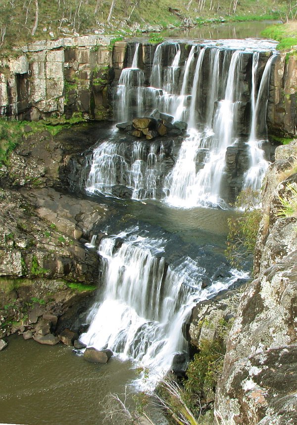
Dangar Waterfall. Only about 1.2 km west of Dorrigo, it is a 30-m high cascade waterfall on the Bielsdown River. For a short time after rain, they are quite spectacular. It is a lovely wide waterfall dropping off into a large pool. The falls are a result of a lava flow from Mt Ebor that rose 600 m over its 1 million year existence. There is a great parking area and picnic site here. It is possible to climb down the banks and walk along the river below the water falls.
In the past, the waterhole has been the scene of several tragic accidents due to jumping.
NSW CENTRAL & WEST
Guy Fawkes River NP
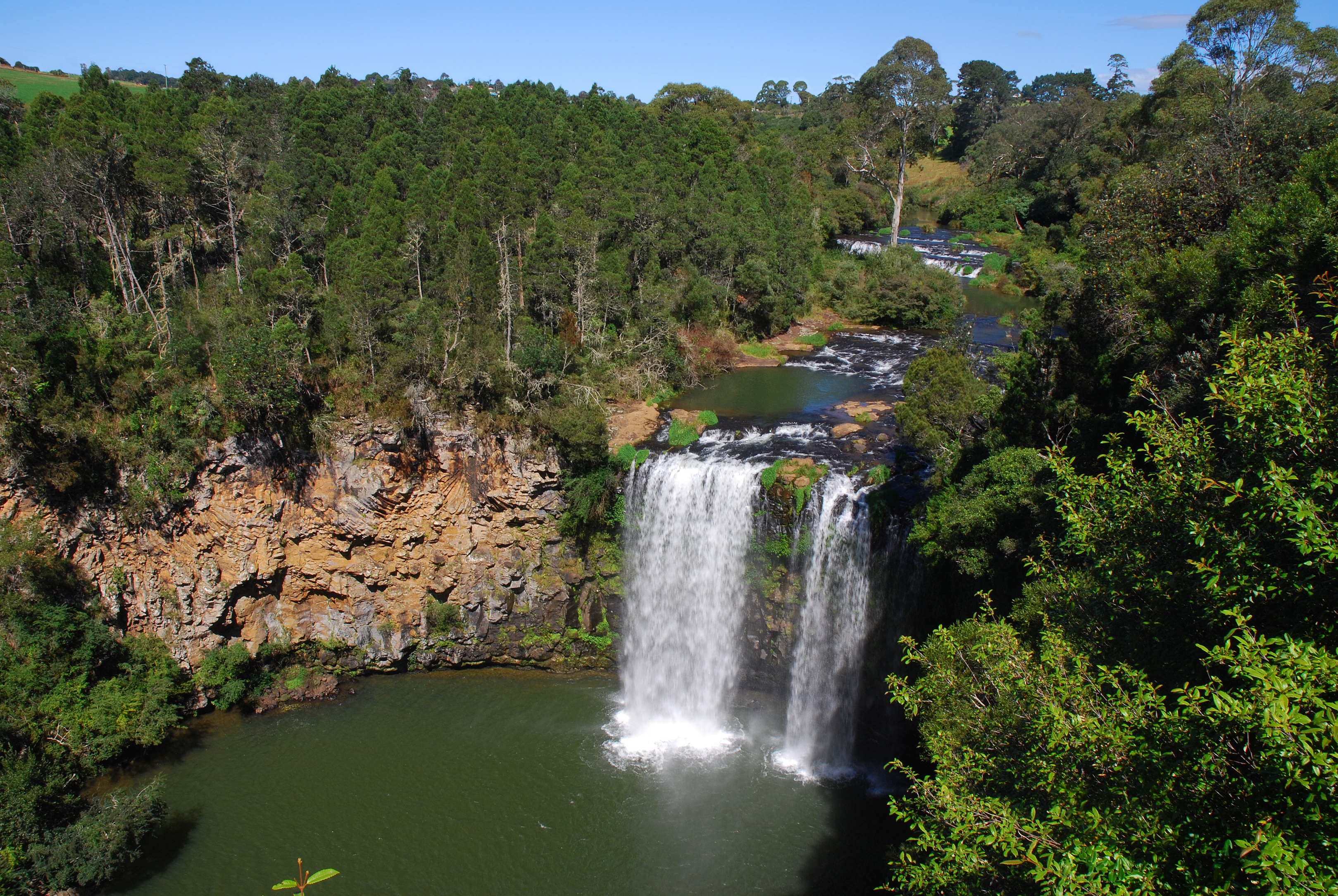
Ebor Falls. The Guy Fawkes River falls 100m over two waterfalls with three lookout platforms along the edge of the gorge. The first lookout is on a sealed road, approximately 200 metres (660 ft) off the Waterfall Way. This viewing platform shows the upper falls tumbling 115 metres (377 ft) over 4 layers of columned basalt rock in two falls. The lower Ebor falls, 600 metres (2,000 ft) further on, plunge over Permian sedimentary rocks into a steep forested gorge below. An easy walking track links the upper falls and lower falls lookout platforms via the escarpment edged.
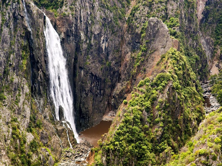
Wollomonbi Falls is a plunge waterfall on the Wollomombi River in the Oxley Wild Rivers National Park approximately 40 kilometres due east of Armidale. From an elevation of 907 metres above sea level that falls are one drop of 100 metres, with a total of 150–230 m depending on the flow of the river.
At one time they were believed to be the tallest in Australia. However, recent geographical revisions place them at second or third tallest, after the Tin Mine Falls in the Snowy Mountains and the Wallaman Falls, near Ingham, Queensland.
Several camp grounds and walking tracks are adjacent: 4-km long Wollomombi Walking Track and the 2.5 km Chandler Walking Track.
Day 72 Fri Dec 1
Glen Innes. Town
At Glen Innes, I had a decision to make, continue north to see the Stanthorpe Heritage Museum and the Cobb & Co Museum (over 200 km) or to turn east and head toward Coffs Harbour, 225 km away. I decided on the latter, passing through Gibraltar NP (Raspberry Lookout) and Washpool NP, both part of the Godwana Rainforest WHS.
Yamba. A town on the water, I sat at a wayside and did a lot of research on my South Pacific trip.
BALLINA
Big Prawn. A huge prawn supported on a grid of 8 girders. In a Bunings parking lot.
Ballina Naval and Maritime Museum. With the most ship’s models of any museum in Australia, this has everything imaginable about marine life. A very busy exhibit. $5
ON Park in Ballina.
Day 73 Sat Nov 2
Cape Byron Lighthouse. Byron Bay. A great white stone lighthouse at the very tip of Cape Byron. It has expansive views down to huge crescents of beach in both directions. Parking $10.
GONDWANA RAINFORESTS of AUSTRALIA WHS
Includes several protected areas along the Great Escarpment in 41 different parks. In southeast Queensland are Lamington National Park, Mount Chinghee National Park, Springbrook National Park, Mount Barney National Park and Main Range National Park. In northeast New South Wales are Barrington Tops National Park, Dorrigo National Park, Mount Warning National Park, New England National Park, Oxley Wild Rivers National Park, Washpool National Park, Willi Willi National Park and Werrikimbe National Park.
When Australia separated from Antarctica following the breakup of Gondwana, new asymmetrical continental margins parallel to the coastline eroded resulting in the Great Divide and the Great Escarpment. Volcanoes erupted in sequence along the east coast during the Cenozoic Era as the Australian continental plate moved over one of the planet’s hot spots resulting in the Tweed, Focal Peak, Ebor, and Barrington volcanic shields. Ongoing geological and biological processes produced marked biological diversity with ancient origins in Gondwana, many only found here.
The Tweed Shield erosion caldera is possibly the best-preserved erosion caldera in the world, notable for its size and age, has a prominent central mountain mass (Wollumbin/Mt Warning), and shows all three stages in the erosion of the caldera floor to basement rock.
Further south, the remnants of the Ebor Volcano also show ongoing erosion of a shield volcano.
Included are the oldest of the world’s ferns from the Carboniferous Period, Conifers from the Jurassic Period (Araucarians are the most ancient and phylogenetically primitive of the world’s conifers). Angiosperms include primitive flowering plants originating in the Early Cretaceous, the primary radiation of dicotyledons in the mid-Late Cretaceous, rainforests from the ‘golden age’ of the Early Tertiary, and Miocene vegetation, the antecedent of modern temperate rainforests in Australia.
Many songbirds: lyrebirds, scrub-birds, treecreeper, bowerbirds, and catbirds (some of the oldest lineages of passerines that evolved in the Late Cretaceous).
Plants and animals show relatively recent evolution. The rainforests provide a series of distinctive habitats showing an endpoint in climatic and geomorphological evolution. The distances between these ‘islands’ of rainforests represent barriers to the flow of genetic material for those taxa that have low dispersal ability. This pressure has created the potential for continued speciation. More than 270 threatened species as well as relict and primitive taxa.
Rainforests covered most of Australia for much of the 40 million years after its separation from Gondwana. These contracted as climate changed and the continent drifted northwards. By European arrival, rainforests covered only 1% with suitable climatic and protection from fire. Clearing for agriculture has resulted in only a quarter of the original remaining.
Protected are the largest and best stands of rainforest habitat, rare and threatened flora and fauna species that are rainforest specialists, a diverse range of heaths, rocky outcrop communities, forests, and woodlands. A high diversity of plants and animals in a habitat for rare threatened, and endemic species. Recently found and thought to be extinct: the Hastings River Mouse and Parma Wallaby.
The Gondwana Rainforests contains the largest and most significant remaining stands of subtropical rainforest and Antarctic Beech in cool temperate rainforests in the world, the largest warm temperate rainforest, and one of only two remaining large areas of Araucarian rainforest in Australia.
Small size and reasonable proximity with connecting corridors of semi-natural habitats and buffers make intensive management possible.
My Experience. In my drive through NSW Western and Central, I went through several National Parks included in this serial listing: Dorrigo NP, , Guy Fawkes River NPOxley Wild Rivers NP, Giltralter NP and Wishpool NP. Mount Warning is also included but I decided to not make the detour as it is not possible to to the trek or access the mountain.
Mount Warning Summit Trek. In the NM Trails 2 – Hikes series. This trail is permanently closed to visitors out of respect to the original Aboriginal custodians. The summit of Wollumbin is a sacred place to the Bundjalung People, and was declared an Aboriginal Place in 2014. Wollumbin, which means ‘cloud catcher’ to some Aboriginal People, is a traditional place of cultural law, initiation and spiritual education for the people of the Bundjalung Nation. Under Bundjalung law, only certain people can climb the summit.
The Aboriginal group and NSW National Parks and Wildlife Service have come to an understanding to have the area closed off for good. Wollumbin is interconnected to a broader cultural and spiritual landscape that includes creation, dreaming stories and men’s initiation sites of deep antiquity,’ it said.
The trail in the national park leads to a breathtaking extinct volcano and welcomes hikers from across the country and around the world.
GO TO QUEENSLAND
