
Day 13 Tue Jan 3
I was up early and got a taxi to the Addis airport to get my flight to Jinka in the Lower Omo Valley, a World Heritage Site.
As I was waiting for the taxi, the hostel night guy told me of a hostel guest, who at 1:00 am when returning to the hostel on the small but main street 100m from the hostel was beat up, robbed of his phone and money and murdered (he kept making a motion across his neck like his throat had been cut but I am uncertain).
My hope was to rent a car for 3 days and drive back to Addis but it appears that cars cannot be rented in Ethiopia. All private transport is by 4×4 and driver. I had no idea what to expect and was basically flying by the seat of my pants. Maybe it would be public transport all the way.
Ethiopia – South Nations, Nationalities, and Peoples (Hawassa)
Borders: Ethiopia-Kenya, Ethiopia-South Sudan – Borders Kenya to the south (including a small part of Lake Turkana), the Ilemi Triangle (a region claimed by Kenya and South Sudan) to the southwest, the South West Ethiopia Region to the west, the Oromia Region to the north and east, and the Sidama Region to the east. The regional government is based in Hawassa but is outside of the boundaries of the region.
Estimated total population of 14,929,548, 89.98% rural inhabitants,
Religion. Protestant 55%, Othodox 20%, Muslim 14%, Traditional 7%, Catholic 2%.
Ethnicities. Welavta 11%, Hadiva 8%, Gurage 20%, Gamo 7%, Kafficho 5%, Silt’e 5%, Amhara 4%. 45 indigenous ethnic groups
Languages. Because of the relatively few number of speakers of most of the languages, the working language of the state is Amharic
Agriculture. Coffee 44.2% of the total production in Ethiopia, 20.5% of Ethiopia’s total cattle, 3,270,200 sheep (18.8%), 2,289,970 goats (17.6%), 298,720 horses (19.7%), 63,460 mules (43.1%), 278,440 asses (11.1%), 6,586,140 poultry of all species (21.3%), and 726,960 beehives (16.7%).
OMO Valley
Lower Valley of the Omo. WHS. A prehistoric site near Lake Turkana, the lower valley of the Omo is renowned the world over. The discovery of many fossils there, especially Homo gracilis, has been of fundamental importance in the study of human evolution.
It extends over an area of 165 km2.
The Lower Omo Valley includes the Konso and Fejej paleontological research locations with sedimentary deposits going back to the polio-Pleistocene period. These have produced numerous hominid and animal fossils, including fragments of Australopithecus. The deposits of human vertebrae fauna, and paleo-environmental evolution, shed light on the earliest stages of the origins and development of Homo sapiens of Africa. The discoveries of ancient stone tools in an encampment also offer evidence of the oldest known technical activities of prehistoric beings spanning between one and 3.5 million years.
All ethnic groups in the region are being exploited by tourism. They have become tourist attractions. Some traditions are fascinating but once they’ve reached a certain level of popularity, they tend to be performed. Like a human zoo – over-commercialized, over-priced, and the entire region ruled by an unregulated tourism mafia. Especially with the all-inclusive packages from Addis – 900 US$ for a 5-day tour. The drivers only want to take you to the touristy towns. Market Days in the Omo Valley are held weekly in each town.
Things are organized for tourists because they want to see it and pay. You are a white person who brings money and other presents. It is often recommended to not go there. Pay hundreds for unnecessary guides that will walk you through the market making the experience worse.
You can get a better experience by spending more time, trying to become a part of the community a little better and asking around. There are many small villages that you don’t pay, untouched and no crowds. Many may not be open to tourists. It is often the unscheduled places that are best. Meet locals through couchsurfing.
Jinka. Local tour operators are unregulated, unprofessional, rude, and mafia-like. Recommended to completely skip any contact with them. One may end up paying more for them than a regular tour from Addis who take care of their reputation. Jinka can be pleasant and authentic.
Saturday Market.
Hostel Mekuria on Hostelworld.
Mursi. Lip plates are the major draw and these are the tribe that account for the entire reputation of the valley. The custom of wearing a lip plate is linked to the female’s fertility and eligibility for marriage. When a Mursi girl reaches puberty (around age 15 to 16) she will have her lip cut by a female member of the tribe and a small wooden stick is inserted. the larger the clay plate, the more the woman is worth before she gets married.
A girl’s lower lip is cut (sometimes by her mother) when she reaches 15 or 16, and held open by a sodden plug until it heals. It’s up to the girls how far they want the lip to be stretched. The very painful process often takes over several months. Lip plates are more frequently worn by unmarried girls and newlywed women than by older married women with children. They are generally worn on occasions such as serving men food, milking cows, and important rituals like weddings.
Unmarried girls, especially those with large labrets, might wear them whenever they are in public. The lip plate carries a number of meanings. Firstly, it’s a symbol of great beauty. Secondly, it marks a commitment to the husband because it is worn with great pride when serving him food. If the husband dies, the lip plate is removed since a woman’s external beauty is said to fade after his death. Lastly, the plate is a powerful visual marker of Mursi identity. Without it, they run the risk of being mistaken for a member of another tribe. Although very unique and part of their tradition, the Mursi women only wear the plates for a short time because they are so heavy and uncomfortable.
It affects the speech of women since it alters the articulators needed for speech production: the lower lip and the lower incisors. Due to the effect of this practice, women cannot produce bilabial and dental consonants in their language.
Pay a national park fee, a tribal guide and for each photo. Many tourists feel like visiting is a complete scam, expensive, short visits, and unpleasant. Can be confusing about what is real and what was fake. Need to get off the beaten path to find genuine experiences. Tourism is still in a very awkward place in Omo valley, but the authentic is still there just beyond the tourist mafia system. Expect to pay for photos.

Key Afer- Thursday market. Pay entrance, controlled
Turmi- Monday and Tuesday markets. Able to have authentic experiences, visit several Hamer villages with no payment. The jumping of the Bulls ceremony may be fake.
Dimaka- Saturday and Tuesday markets.
Konso- Friday and Monday markets. More authentic.
Flight: ADD – Jinka (BCO) @ 07:40 – 10:40. The plane arrived about 50 minutes late. The Jinka airport is as spartan as it gets – the only bathroom is a dilapidated metal sheet shed 100m from the minimal airport. I was immediately met by a “tour guide” who offered to drive me to Turmi to see the Hamer people and then drive to Konso for $350. I told him he was a tourist mafia.
I got a tuk-tuk into Jinka to the bus depot for 200 birr. A share van was leaving for Konso at 6 pm for 500 birr so I rather reluctantly (after two previous long bus rides, I was more than jaded) jumped on the bus to leave at noon for 200 birr. It was about 200 km for the same price as 4 km.
It was noon before it left but I lucked out with a good seat – a front bench seat with lots of leg room and a big padded bolster that is over the engine that I could completely stretch out my legs. As always I am the only white person on these public buses, 40 or so bad seats, usually packed full. After loading several huge sacks and getting gas, we finally left Jinka at 12:30 on a fair road with only a few large. pot holes. The major impediment was all the horned Brahma cattle who wondered down the middle of the road impervious to us. Plus some goats.
After an hour we reached Key Afar, one of the good market towns. Outside we were stopped by a road barricade, everyone got off and walked to the other side while the police did a cursory inspection of the contents. The little kids looked at me as if they had never seen a while guy.
The landscape is a hilled, dry, treed country surrounded by low forested mountains. We went over four low passes and then crossed broad flat valleys with arrow-straight highway.
Two-thirds of the way to Konso, at Woto, we pick up many passengers – it is standing room only and six guys are sitting on the bolster, including one guy in between my knees. We stopped in the middle of nowhere and loaded 20 bundles of thin firewood and two giant sacks of charcoal.
As we approach Konso, the hilly country is completely terraced. The drive took about 4 hours.
Konso is a gritty little town high up on the side of a mountain. There were four hotels in town. but only one that seemed reputable.
Konso Cultural Landscape. WHS is an arid property of stone-walled terraces and fortified settlements in the Konso highlands of Ethiopia. It constitutes a spectacular example of a living cultural tradition stretching back 21 generations (more than 400 years) adapted to its dry hostile environment. The site also features anthropomorphic wooden statues – grouped to represent respected members of their communities and particularly heroic events – which are an exceptional living testimony to funerary traditions that are on the verge of disappearing. Stone steles in the towns express a complex system of marking the passing of generations of leaders.
ON Konso Edget Hotel 2. A small room with a single bed and tiny bathroom, but was clean. 250 birr. It has a huge busy bar with many outside tables. The guy in the nest room snored so loud that he kept me awake.
Day 14 Wed Dec 4
I was up early and down at the bus station at 05:30 to get the long bus to Addis Ababa 1000 birr. 532 km.
We were stopped at a police checkpoint just outside of Konso. They were jerks and threw a bunch of luggage (in plastic bags) off the bus. As were stopped, a minivan with 100s of live chickens on the roof rack stopped near us. We had many passengers with live chickens (they carry them upside down by the legs) – this is the classic food at this big Ethiopian festive season.
A village we passed was crowded with people, donkeys drawing carts with car tires and drivers standing, goats and a lot of cattle (skinny, all their ribs show).
Arba Minch. It took 2’20” to drive the 88 km here. It is an attractive city with good roads, lovely roundabouts, no garbage and a lot of new construction.
We finally stopped past Bhodit for lunch with 20 minutes to eat. All they said they had was vegetables and I got a large portion of soggy spinach and a very small portion of good sautéd vegetables with some day-old hard bread. I sent the spinach back and got more vegetables with some spaghetti – all good, but now had only 5 minutes to eat it. 60 birr. Virtually the entire bus emptied in Bhodit and I slept across the 5 seats.
We stopped several times to gather branches for the goat riding on the roof.
Passing through the treed country with yellow savannah, the route taken did not go to the east side of the Rift Valley and Adama but continued straight to Addis. Fortunately, Tiya, a WHS was on the route. My plan if we didn’t go this way was to go to Addis and spend January 5th coming down the 100 km to Tiya. This was going to save me almost a full day.
I had almost no birr left so walked 600 m down to the NOC Bank, in a filling station. The ATM didn’t work because it wasn’t connected to electricity but the branch was open. I think I gave them their most interesting transaction for a while when I wanted to exchange 20€ for birr (1800 black market, 1140 official). They brought out a bill counting machine to check if the bill was counterfeit but it only worked for US$. I showed them how to use the watermark on all bills to ascertain if it was real. I got 1123.2 birr for the twenty.
I tried to buy milk and kept getting pointed down the block but after 6 small shops, I realized there was none in Tiya. For dinner, I eventually had two deep-fried pastries with spiced meat and 2 coffees for 60 birr ($1.20) so it was a pretty cheap place to eat. Another place had ingura but I have gotten tired of that (Ethiopians eat if for BF, lunch and dinner).
ON I’m not sure of the name of the hotel but it appeared to be the only one in Tiya. The room was very basic and of questionable cleanliness but had a bed and 2 chairs. The bathroom was gross with no running water, a toilet that had not been flushed for some time and garbage lining the shower walls. The one electrical plug didn’t work – a power bank is a necessity for travelling in these countries for situations like this. 200 birr (~$4).
With nothing to do here except drink beer, I was in bed at 20:00 to read and finish this post. It was very cool and I killed several mosquitos (who weren’t biting) as they flew across my computer screen.
A donkey tied up in the yard brayed all night.
Day 14 Thur Jan 5
I bought some pens (they keep falling through a hole in my pocket) and breakfast of coffee and deep-fried doughnuts and then walked about 1/2 km to the Tiya WHS.
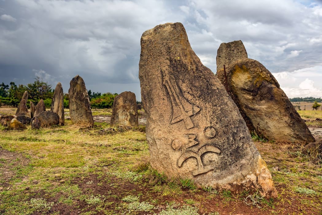
Tiya. Tiya is among the most important of the roughly 160 archaeological sites discovered so far in the Soddo region, south of Addis Ababa. The site contains 41 monuments in three areas – 33, 4 and 4 stelae, all carved stelae covered with symbols – swords (indicates warriors killed), breasts, bananas and head rests. 52 graves were excavated, 51 of them in a sitting position. The graves sit behind the stelae. One pre-Christian symbol was a stone phallus. Three flat stones had a shield, a good representation of a queen with head, hanging breast, arms and skirt and a drum. They are the remains of an ancient Ethiopian culture whose age is thought to be from the 7th to 14th centuries. 310 birr.
I then caught a share van to Addis at 10 am getting a great front seat. 200 birr. They loaded a “pen” made of branches, chicken wire and a large nylon bag full of live chickens. One never sees chickens for sale at any restaurants and it appears they are saved for Christmas being held this week. Chickens are everywhere and several people on the buses and vans have one or two.
The drive is through a lovely open savannah, all yellow stubble and stacks of straw from the harvested wheat crops and spotted with trees. We pass a huge herd of camels, incongruously out of place as this is hardly desert, although most of the trees appear to be acacia. I feel sorry for the donkeys (and some horses), seemingly small for most donkeys, they are the beast of burden hauling huge loads on carts with big car wheels.
After driving all over to deliver the chickens, I arrived 12 km from the airport at 12:30, took share vans in the general direction for 5km and finally got a taxi. He took me to the common black market money exchange and I got 80 birr/€ (instead of the official 56.5). I would have gotten 90 for a 100€ bill.
Flight ADD to Dire Dawa @16:30-17:50 3589 birr
When I deplaned, I started talking to a guy from Harar who was having a driver pick him up and he offered me a ride to Harar – only 58 km but 1 1/2 hours of bad roads and busy traffic. I doubt that I would have been able to get here today.
We passed through a town solely devoted to producing qat, the mild stimulant that is chewed.
He took me to a hotel and I offered him a beer. As a born-again Christian, he doesn’t drink so he had tea. We talked a lot about the nonexistence of evolution and that the Earth was formed 6000 years ago, and that homosexuality was not natural. He is a civil engineer, speaks great English and is a good conversationalist.
ON Harar Ras Hotel. 12,000 birr ($23). A significant upgrade from last night, the room was clean (but not the walls), it had bedding, a functional bathroom but was not much bigger. The TV worked but all 6 channels were the same, a show about a water bottling facility. Free BF at 6 am.
Sample Itinerary to see the entire Omo Valley and Rift Valley) Ethio Backpacker tours:
Day 1 Langano – Arba Minch, 306 km / 6 hrs. Resort at the lake, visit Senkele Game Sanctuary to see the endemic Swayne hartebeest and other savanna Animals. O/N paradise lodge
Day 2: Arba Minch. Drive 28 km to the highland village of Dorze at 2600 m – vistas over Lake Abaya and Lake Chamo. Visit the Dorze people in their famous beehive-like huts. One hour boat trip on Lake Chamo to see crocodiles, birds and hippopotamus. ON Paradise Lodge.
Day 3: Arba Minch – Jinka, 241 km/ 4:30 hrs. Drive south via Konso, Tsamay, Banna and Ari people. Thursday market of Key Afar where Banna, Ari and Tsamay people attend plus a cattle market. After visiting the market, drive to Jinka. ON Jinka lodge
Day 4: Jinka (visit Mursi and Ari people). Mago National Park to a village of the Mursi and the most well-known people of the Omo Valley. Return to Jinka for lunch. Afternoon visits the Ari people. ON Jinka lodge
Day 5: Jinka – Turmi 125 km/ 2:30 hrs. Museum at the South Omo Research Centre., Drive to Dimeka for the Saturday market day. Mainly Hamer people but also Karo, Bashada, and Banna travel here. Evangadi dance or maybe a Bull-jumping ceremony. ON Turmi lodge
Day 6: Turmi. Drive 72 km/ 1,5 hrs. Cross the Omo River by local canoe to Omorate to see the Dassenech people. Return to Turmi. ON Turmi Lodge
Day 7: Turmi – Yabello, 296 km / 5:30 hrs. Walk around Turmi. Follow the Keske River (usually no running water) to see black and white Colubus monkeys and birds. Drive to an Arbore village. Visit the Konso village of Yabello, with its maze-like villages, terraces for agriculture and Waga stelae, grave markers for the brave and important men of this people. ON Yabello hotel
Day 8: Yabello. Borena people – pastoralists with camels and cattle living in semi-arid savanna. “Singing wells” to witness the chain of people bringing up water, and singing to keep their spirits up. The Crater of El Sod has a salt lake with a challenging walk down and up to see the harvesting of salt. ON Aregash lodge
Day 9: Yabello – Yirgalem, 262 km/ 5 hrs. Leave the semi-arid savanna to hills with coffee ON Aregash Lodge, an eco-lodge on a coffee plantation in Yirgalem.
Day 10: Yirgalem – Goba 274 km / 5 hrs. Visit the fish market in Hawassa. Go to the headquarters of the Bale National Park in Dinsho to see the endemic mountain Nyala and Menelik bushbuck. Proceed to Goba. ON Wabe Sheblla hotel.
Day 11: Goba. Explore the Bale Mountain NP to see the Ethiopian wolf and many birds. ON Bale mountain lodge
Day 12 Goba – Addis Ababa, 414 km/ 8 hrs. Leave Bale NP down to the bottom of the Rift Valley via a very scenic road, via Asela.
World Heritage Sites
Gedeo Mixed Cultural and Natural Landscape Tentative WHS: (27/12/2012) Gedeo is located in the southern part of Ethiopia. Gedeo occupies the Eastern margin of the Southern main Ethiopian Rift between the Abaya Lake (1200 meters asl.) in the West, and the mountains that reach 3200 meters asl. located to the East – 150 km distance from North to South and 40 km from East to West. This hilly terrain with an area of 1347 km² hosts over 1.5 million people. This makes it the most densely populated zone in the Southern Nations, Nationalities and Peoples’ Region. Knowledge-based self-sustaining land use system growing indigenous trees in combination with crops (coffee, enset, root crops), and livestock. The land has a remarkable variation in altitude and geomorphology within a short distance – from 1200 m a.s.l. in the East (the Rift floor) to 3200 m a.s.l. in the West within 30 km distance. Cultivating land with slope gradients above 30%, growing enset and coffee with native trees like Millettia ferruginea as coffee and enset plants benefit from its shade.
Archaeological sites. megalithic sites dating from 8th-15th century.
Tuto-fela Located at N 6 19 10 and E 38 21 23.9. Both phallic and anthropomorphic stelae are erected on a large cairn. All but 5 stelae in Tuto-fela are still in erect, 54 are complete, and 53 are carved stelae depicting different symbols. 105 individual human remains were exhumed. The size of the stelae varies between 0.70 m to 2.50 metres in height.
The stelae with crossing lines made either by curving out the shape or incised using sharp tools.
Chelba-tutiti. Located at 38° 11′ 48.48″/6° 15′ 41.04″; 2500 meters above sea level. The majority of the stelae are found lying on the ground 4 and 8 m high. The tallest stele is 8 meters high has 1.80 m diameter. Decoration depict rays of lines radiating from a central disc.
Sede-mercato Megalithic site. At a village called Kib at 6° 07′ 05.4″ N 038° 10′ 59.9″ East; The majority still standing – 664 total, longest is 2.60 m, circumference 1.28 m.
Sakaro-sodo megalithic site 3.3 km north of Gedeb at 5 56 55.3 N and 38 15 17.5 E. 43 phallic stelae, 8 are intact and standing, 2.17 – 3. 52 metres.
Odola-galma Rock art site on two panels on the right and left banks of the Anshi-malcho River. Left bank has 8 bovids; right bank has 11 bovids 12 cm-46 cm long. Long thin horns. Date from 3rd and the 2nd millennium B.C.
Sacred forests are often burial sites with often large and very old trees. Are never cut or injured. 107 trees and shrubs,
Wogida Amba sacred forest. Located between 6°9’46.096″N 609’54.891″N and 38°15’48.032″E-38°16’2.305″E longitude. 6.56 hectares.
Bolocho sacred forest. 18.5 hectares located between 6°22’10.336″N- 6°22’29.45″N latitude and 38°21’45.85″E- 38°22’4.264″E longitude.
Birbirota sacred forest. 0.91 hectares between 6 21 46.676 N 6 21 50.633 N latitude and 38 19 25.778 E 38 19 31.047 E longitude.
Basura sacred forest and grave yard. 1.4 hectares between 6 19 3.4 N – 6 19 8.18 N latitude and 38 21 39.838 E – 38 21 46.404 E longitude.
==============================================================
Ethiopia – Oromia (Adama, south, west)
Borders: Ethiopia-Kenya, Ethiopia-South Sudan
ADAMA (NAZRET) World Cities and Popular Towns
St. Mary Church (እግዚአብሔር አብ ቤ/ክርስትያን).
JIMMA
Abba Jiffar Palace
NEKEMTE
Kumsa Moroda Palace, Built by the King Kumsa Moroda in the 1870s. It served as a residence to the prominent Worra Bakaree family until the 1960s. The compound consists of around 10 buildings, admission includes a guide.
SHASHAMANE (pop 208,368), The town is known for its Rastafarian community. The resort of Wondo Genet lies near Shashamane, as does the Senkele Wildlife Sanctuary.
Bale Mountains National Park Tentative WHS(13/03/2008). Expansive nature park with diverse vegetation, birdwatching, wildlife & excursion tours. The perfect place to get away from the hustle of Ethiopian cities! Cold and lush. Although a big problem here is the amount of human and livestock encroachment into the park
Dirre Sheik Hussein Religious, Cultural and Historical Site Tentative WHS (14/12/2011). It is a 10th-century Islamic centre of pilgrimage for people coming from different corners of the country, and Islamic communities of the Horn and the Middle East countries, twice a year. Dirre Sheik Hussein is a site of magnificent groups of buildings, monumental tombs and courts representing the early medieval period of Islamic architecture and buildings of significant engineering qualities.
The holy site was founded by the Islamic Saint Sheik Nur Hussein. He was one of the Nine Islamic venerated saints who entered Ethiopia (from South Arabia). The site is a large rural religious walled settlement still serving the living culture of the past that continuously occupied the Islamic community. Considered a sacred site with a large area of spiritually protected forest landscape.
Holqa Sof Omar: Natural and Cultural Heritage (Sof Omar: Caves of Mystery) Tentative WHS (14/12/2011). The road from Robe to Sof Omar is 100km of gravel/rock and it is very ruff and slow travel, about 3 hours. 2 entrances, 15km long but walking from end to end outside only took like 30min. Gorro, 46 km away is the last restaurant and fuel. An awesome place, worth every bump of the 100km. Bring your own flashlight.
Melka Kunture and Bachilt Archaeological Site Tentative WHS (27/12/2012). Dig site where Homo Erectus and Homo Sapiens were found. Superb explanation of Great Rift Valley archeology and geology. 40,000-year-old Stone Age tools. Adadi Maryam church closed. One hour’s drive from Addis Ababa.
Debre Libanos Monastery, Semien Shewa Zone. Founded in the 13th century by Saint Tekle Haymanot, according to myth, he meditated in a cave for 29 years. The modern church was built in 1950 by Emperor Haile Selassie to replace the one which was destroyed by the fascist Italians during their occupation on 20 May 1937 furthermore they shot 297 and 100 young deacons within a short period.
==============================================================
Ethiopia – Oromia – East Herarge (Dire Dawa, Harar)
DIRE DAWA Dire Dawa is a city in Ethiopia divided by the usually dry Dachata River. The colonial quarter, Kezira, features wide streets and a rail station dating from the French development of the railway. Megala, the old town, has Islamic-style architecture and several markets. Dominating these is the popular Kafira Market, which has local produce. Ancient rock art sites, including the Porc Epic Cave, are outside of town.
Airports: Dire Dawa (DIR)
St. Augustine Cathedral
Railway Museum
Day 15 Fri Dec 6
HARAR (pop 99,368 2007) is an ancient city is located on a hilltop in eastern Ethiopia about five hundred km from Addis Ababa at an elevation of 1,885 metres (6,184 ft).
For centuries, Harar has been a major commercial center, linked by the trade routes with the rest of Ethiopia, the entire Horn of Africa, the Arabian Peninsula, Asia, and through its ports, the outside world. Harar Jugol, the old walled city, was listed as a World Heritage Site in 2006. According to UNESCO, it is “considered ‘the fourth holiest city’ of Islam” with 82 mosques, three of which date from the 10th century, and 102 shrines.
Several religious leaders settled in the Harar plateau c. 1216 (612 AH) and made the new capital of the Adal Sultanate in 1520
History. The modern city of Harar dates back to the 1700s at the earliest but was a city for much longer. Harar emerged as the center of Islamic culture and religion in the Horn of Africa during the end of the Middle Ages.
During the period of Egyptian rule (1875-1884), Arthur Rimbaud lived in the city as the local functionary of several different commercial companies based in Aden; he returned in 1888 to resume trading in coffee, musk, and skins until a fatal disease forced him to return to France. A house said to have been his residence is now a museum.
Harar is the birthplace of the khat plant. The original domesticated coffee plant is also said to have been from Harar.
The climate is subtropical highland climate with afternoon temperatures warm to very warm throughout the year whilst mornings are cool to mild. Rain falls between March and October with a peak in August, whilst November to February is usually dry.
48.54% Ethiopian Orthodox, 44.56% Muslim, and 6.14% Protestant.
The old walled city of Harar is divided into 5 quarters which are further divided into about 59 neighborhoods called toya, which are often named after a Muslim shrine or a prominent tree serving as a local landmark. In the late 1960s, it was still possible to walk around the outside of the city walls on foot for an hour. By the early 1980s, though, this was no longer possible because the city had begun to expand.
Some buildings are directly attached to the outside of the wall. A walled compound (abāt) consists of several residences, which share the same walls but are not interconnected, but are arranged around a courtyard, and share one or two kitchens, which are disconnected from the residences. Sometimes several compounds are joined into a “block” of compounds. Building materials are local stone and plaster that is whitewashed. Ceilings are made of varnished wooden planks and floors are traditionally red earth often tiled.
Besides the stone wall surrounding the city, the old town is home to 110 mosques and many more shrines, centred on Feres Magala Square. Notable buildings include Medhane Alem Cathedral, the house of Arthur Rimbaud, the sixteenth-century Jami Mosque and the historic Great Five Gates of Harar.
A long-standing tradition of feeding meat to spotted hyenas evolved during the 1960s into an impressive night show for tourists.
Harar Jugol is a rare example of a relatively well-preserved historic town that has retained its traditions, urban fabric, and rich Harari Muslim cultural heritage to the present time. The historic city is physically limited and well-defined by its 16th-century surrounding wall
With BF at 6, I was up early, but the BF was not worth it – four stews of unknown ingredients, spicy boiled potatoes, buns, inguira and lots of coffee with milk. I left the hotel to see Harar, the WHS walking down the main street for a km to the gate of the walled town.
Harar is a very messy town mostly because of all the people and thousands of tuk-tuks – blue, Indian-made and spewing fumes from their polluting 2-stroke engines. One would not know it was Christmas day in Ethiopia as nothing seems different, certainly no Xmas decorations or Santa Clauses – this is a predominantly Muslim city.
On the walk down, I pass an untold number of donkeys carrying sticks of sugar cane all led by teenage girls. No wonder there is so much dental disease in this country. There are also herds of goats being pulled along by their young owners.
Harar Jugol, the Fortified Historic Town. WHS. In eastern Ethiopia, it’s surrounded by a centuries-old defensive wall that has several large gates, including Duke’s Gate. The city is known for its mazelike alleys and traditional houses decorated inside with flat hanging baskets. A replica house features at the Harar Community Centre Museum. A holy Islamic city, Harar has many mosques, including the Grand Jami Mosque with its tall white minarets.
The historic town is centred on one long street on the crest of a hill with a myriad of tiny lanes leading downhill on both sides. Many of the homes are tall or with high walls.
Emir Nur’s Tomb. Emir Nur’s Tomb resembles a spiky green beehive. It’s devoted to the ruler who built the city’s walls, and his wife is also buried inside. You enter the tomb normally, but when leaving, you should back out. The tiny tomb is draped with a green flag with barely room to move. 50 birr. The guy who led me to the tomb and simply pointed at it asked for 100 birr to guide me.
Rimbaud’s House & Museum. A beautiful building in Jegol, the house of former French poet Arthur Rimbaud who was given shelter in Harar. There are photos of the old Harar taken by Rimbaud which is the major attraction. You will see how much has changed or remained.
This is a large lovely three-story house with wood upper stories. Enter a nice library lined with books, tables and chairs. Climb up a nice staircase to the main room open above. Photos of old Harar hang from the ceiling and line the walls. The third story has a low painted ceiling and banister looking down onto the second floor. All the walls are wood with blue, green, red and white stained glass windows. 50 birr.
I returned to the hotel, had a good shower, printed some documents and walked one km to the bus station to catch a bus to Jijaga, Somali province. For some reason, I didn’t look for a share van but boarded the bus that quickly filled. We were off at 11:50 for the long 100 km drive. 150 birr. Luckily the only person on the bus who spoke English, a skinny guy who was a government worker from Jijiga sat next to me. My big pack luckily fit under the seat, so the ride was relatively comfortable. Everyone on the bus was Muslim.
The road passes through Sahel, a semidesert with prickly pear, bush and acacia trees. Low tree-covered mountains and in some places eroded boulders line the road. There were many Somalia and Ethiopian refugees scattered along the road living in small domed “tents” constructed of thin tree branches covered with all manner of tarps and cloth.
Talking to the guy sitting next to me: he is 28 and has 4 children but wants to have four wives. He says a major problem with Islam is every guy wants to have four wives. Divorce is easy (one only has to say “divorce, divorce, divorce” and it is all over). Child or ex-wife support is rarely paid. His wife wears a full veil because he doesn’t like other men seeing his wife’s face or any skin.
Several things conspired to allow me to get to the Somali Province of Ethiopia and one more NM region. First, the road from Konso to Addis goes through Tiya so I saw the WHS on Jan 5th, saving me a day. Second, I got a great ride from the Dire Dawa airport to Harar allowing me to see Harar WHS on the 6th and then get the bus to Jijiga on the same day. I needed to be back in Addis on Jan 7th to get my flight to Somalia on the 8th and was able to book a flight leaving at 14:00.
As a result, I was able to see seven of the nine regions in Ethiopia and all the WHS.
St. Gabriel Church, Kulubi. It is a highly esteemed church for the Ethiopian Orthodox community. After holding some mud from the yard of this church and praying in front of St. Gabriel, make a wish for anything and that will be fulfilled. A strong belief among these people…….
==============================================================
Ethiopia – Somali (Jijiga)
Borders: Djibouti-Ethiopia, Ethiopia-Kenya, Ethiopia-Somalia
JIJIGA (pop 125,876 2007) became the capital city of the Somali Region in 1995. Located in the Fafan Zone 70 km (37 mi) west of the border with Somalia, the city has an elevation of 1,634 metres above sea level.
History. The region around Jijiga existed as early as the thirteenth century. It is one of the mahalla or halting places of the caravan route between Zeila and Harar. In 1893, it was a stockaded fort with a garrison of 25 men. Jijiga was founded in 1916 and organized in a square grid of streets, built a fort, dug several wells, encouraged agriculture, and made it into a modern urban centre.
British. On 17 March 1941, during the East African Campaign of World War II, Jijiga was occupied by the British 1st African Division after the Italian garrison had already abandoned the city. They left in 1948.
On 29 May 2008, following a heavy downpour, the Jijiga River broke its banks and flooded several kebeles in the town and the vicinity killing 29 people.
It is predominantly Muslim.
The climate of Jijiga is a subtropical highland climate, extremely wet and lush during rainy season, as with the rest of the Ethiopian highlands, Seasonal differences relate only to rainfall, as temperatures year-round are cool to mild in the mornings and uniformly very warm though not hot during the afternoons. The two rainy seasons occur from July to September and April to June.
The vegetation is grassland with pockets of junipers and gum forest in higher altitudes. The common tall grassland tree is used as shelter by the wandering hyena. It is dry season grazing land for all the tribes. The city is surrounded by rocky green mountains on all sides past nearby Harar and to Addis.
Just before Jijiga, we are stopped for a complete security check. Everyone got off with all their luggage, were frisked (everything is out of pockets) and my bag is completely unloaded (this causes a problem as repacking is difficult without care). I am last in line and amazingly, my bus leaves without me. I tried to get a ride with some of the mini-vans but none of the drivers read Amharic. The only bus has an older driver with reasonable English and kindly he lets me board for the short drive into Jijiga.
He let me off at a hotel. Jijiga covers a large flat area and is a typical messy city of dirt and tuk-tuks.
ON Jijiga International Hotel. I initially got a room on the 5th floor but the elevator didn’t get me there, the room (1200 birr or about $23) has no TV and not enough plugs to both use the fan and plug anything else in. I eventually got another room for 1400 birr with a king-sized bed, a TV (I can watch Al Jazeera in English) and a fan that isn’t necessary because it faces east and is not so hot. It is much cleaner and nicer than my room in Harar for 1200 birr the night before.
Day 16 Sat Jan 7
I had all morning to confirm travel plans to Somalia, Djibouti and Eritrea and read.
Flight: Jijiga to Addis Ababa 14:50 – 16:05. I arrived in Addis and had to fight the usual taxi touts with fares to my hostel ranging from 700-400 birr so I walked out to the road and got one for 150 and paid him 200.
I hadn’t eaten since BF and was craving a burger and fries. Today is a holiday and almost all restaurants are closed but I found out 1/2 km from the hostel. It was the best I had had in Ethiopia.
ON Mad Vervet for the third time, and in a dorm room. I am managing my birr carefully so that I have enough but not too much as they are worthless outside the country.
Day 17 Sat Jan 7
Flight ADD to Mogadishu, Somalia @08:55 – 11:05.
I got a taxi early enough to be able to have a BF of foul in the airport.
I am happy to be leaving Ethiopia mainly because i am tired of the food, airport security an general poverty. But I had a great trip seeing seven NM regions (out of 9) and all but one WHS (the Lower Awash Valley where Lucy was discovered – in the Afar, it is virtually impossible to get to because of logistics and expense).
==============================================================
Ethiopia – Benishangul-Gumaz (Asosa)
Borders: Ethiopia-South Sudan, Ethiopia-Sudan
Is a regional state in northwestern Ethiopia to the border of Sudan. The region’s capital is Assosa. The name of the region comes from two peoples – Berta (also called Benishangul) and Gumuz.
The region has faced major challenges to economic development, due to a lack of transportation and communications infrastructure.
Transportation. The Abay River (Blue Nile) divides Benishangul-Gumuz, and there was no bridge crossing it until 2012. The major road that connects the Metekel Zone and the Assosa Zone was built by the China Construction Company in 2012. The road has a 365-meter bridge that crosses the Abay. Nowadays it is simple to travel between the regional capital of Assosa and Gilgil Beles, the capital of the Metekel Zone. Previously 1,250 kilometres, it is now around 378 kilometres on the new road and bridge. Conditions for travel within zones varies but are often poor and subject to disruption by the rainy season.
Ethnic groups. Amhara (25.41%), Berta (21.69%), Gumuz (20.88%), Oromo (13.55%), Shinasha (7.73%) and Agaw-Awi (4.22%).
Religion. 44.7% were Orthodox Christians, 33.3% were Muslim, 13.53% were Protestant, and 7.09% practiced traditional beliefs. It had a projected population of 1,127,001 in 2018.
There are 2 refugee camps and 1 transit center, housing 36,440 refugees from Sudan and South Sudan, located in the Benishangul-Gumuz region.[
===========================
Ethiopia – Gambela
Borders: Ethiopia-South Sudan
Is a regional state in western Ethiopia, bordering South Sudan. The Region is situated between the Baro and Akobo Rivers, with its western part including the Baro River. Its capital is Gambela.
Total population 307,096.
Ethnic Groups. Various Nilotic ethnic majority populations: Nuer 64.66%, Anuak (Anywak) 29.6%, Majang 5%.
Standard of living for Gambela as of 2005: 44% of the inhabitants fall into the lowest wealth quintile; adult literacy for men is 57.5% and for women 22.8%; and the regional infant mortality rate is 92 infant deaths per 1,000 live births, which is greater than the nationwide average of 77; at least half of these deaths occurred in the infants’ first month of life.
Religion. 70.1% of the region’s population are Protestants, 16.8% Orthodox, 4.9% Muslim, 3.8% practice traditional religions, 3.4% Catholic.
There are several refugee camps located in the Gambela region housing around 268,000 refugees from South Sudan in August 2016. From August 2016 to August 2018, the numbers increased from 268,000 to 402,000 refugees, almost equaling the native population of the Gambela Region.
Economy: Coffee. Trypanosomiasis was a major problem in cattle for this region. There was an epidemic of this disease in the area during 1970. Major oil resources.
