
BAHAMAS – New Providence (Nassau), Andros, Exuma, Cat, Inagua. May 8-9, 2022
In my quest to finish all the countries in the Caribbean (and thus the Western Hemisphere), I flew from Montego Bay, Jamaica to Nassau (Frontier, 22 hours with an 18-hour layover in Orlando for $CAD200). I made an attempt to see as much of Nassau as possible and then flew home to Comox (Westjet via Ottawa and Calgary, 13 hours, $400). So this leaves St Vincent & the Grenadines as my only unvisited country – it was simply too expensive to fly and had antiquated covid rules. I was also tired after 10 months and wanted to get home and have a rest.
Covid. Because of my positive test on Feb 10, I wanted to avoid more tests. One must obtain a letter of exemption. I emailed [email protected] with my vaccination record, positive test, Doctor’s letter of recovery, and my passport and promptly received the exemption. The exemption letter had not been added to the travel.gov.bs website and needs to be put in place of the covid test results. Antigen tests are $150 (PCR $300) at the Fort Lauderdale Airport.
Go to travel.gov.bs to fill in the travel visa, one of the more cumbersome travel forms to fill out as you have to list every detail of your covid testing site (phone number, address, zip code) and every other detail of your past life.
Pay $40 for the visa (includes travel insurance)
One must check in daily to report symptoms or face a $100 fine per day.
Not wearing a mask in public faces a $250 fine.
I personally had no reason to come to the Bahamas other than it was another country on my way to 193. I had gotten a cheap CAD$200 flight from Jamaica (Frontier but the $134 baggage fee made it much more expensive. Frontier is the cheapest airline with no free food, snacks, or drinks. No wonder both my flights were essentially empty).
I don’t go to beaches (other than walk and rarely swim), resorts, casinos, bone fish, golf, or shop, which is all the country offers. It is an extremely expensive place suitable for people on a 1-2 week holiday staying at resorts and with unlimited money.
I rented a car ($92/day) as I wanted to see Nassau and taxis were $25 from the airport.
Accommodation is very expensive in the Bahamas. On New Providence (Nassau) there is one place for under $300, Ocean Front Hostel. I tried to find it but it is not on Google Maps. The address is 799 West Bay Street but there is no sign for Ocean Front Hostel, only Viking Hill. I stopped in at Ocean Mist Hotel, 3 doors away and they had never heard of it, but located it from photos on the website. When I arrived, there was no one around. Bahamas Vacations Club sends so many emails that are so long that I mistakenly blocked them out. Apparently one has to call WhatsApp +1 242 432 0468 and inform the host that you are coming. I didn’t have a SIM so was dependent on the wifi to communicate. When talking to her, it was Mother’s Day and she obviously wasn’t coming. She sent my bed number by text. It was occupied so I took the only made-up bed. Apparently, it was someone else’s and she phoned me irrate. This 12-bed door has an income of over CAD$700 per night and one would think they might provide some service.
The room is a 12-bed dorm room. There is one toilet and 3 showers. People lock the door when using the BR even though the showers have curtains and the toilet a separate door. There was no toilet paper. I had luckily saved napkins from Wendy’s at the airport.
I left at 8 am to drive and see what there was in Nassau before my flight home at 13:30.
The hostel is 15 km west of Nassau in an area with no services.
The people of the Bahamas are almost entirely black. Outside of resorts and downtown Nassau, one sees no white folks. It would appear that there is a huge income disparity here.
NASSAU (pop 274,400) is the capital and largest city of The Bahamas with 70% of the entire population of The Bahamas. Nassau is commonly defined as a primate city, dwarfing all other towns in the country. It is the centre of commerce, education, law, administration, and media of the country.
Lynden Pindling International Airport, the major airport for the Bahamas, is located about 16 km (9.9 mi) west of the city centre of Nassau and has daily flights to major cities in Canada, the Caribbean, the United Kingdom, and the United States. The city is located on the island of New Providence.
Nassau is the site of the House of Assembly and various judicial departments and was considered historically to be a stronghold of pirates. The city was named in honour of William III of England, Prince of Orange-Nassau.
Nassau’s modern growth began in the late eighteenth century, with the influx of thousands of Loyalists and their slaves to the Bahamas following the American War of Independence. Many of them settled in Nassau and eventually came to outnumber the original inhabitants.
As the population of Nassau grew, so did its populated areas. Today the city dominates the entire island and its satellite, Paradise Island. However, until the post-Second World War era, the outer suburbs scarcely existed. Most of New Providence was uncultivated bush until Loyalists were resettled there following the American Revolutionary War; they established several plantations, such as Clifton and Tusculum. Slaves were imported as labour.
After the British abolished the international slave trade in 1807, they resettled thousands of Africans liberated from slave ships by the Royal Navy on New Providence (at Adelaide Village and Gambier Village), along with other islands such as Grand Bahama, Exuma, Abaco and Inagua. In addition, slaves freed from American ships, such as the Creole case in 1841, were allowed to settle there. The largest concentration of Africans historically lived in the “Over-the-Hill” suburbs of Grants Town and Bain Town to the south of the city of Nassau, while most of the inhabitants of European descent lived on the island’s northern coastal ridges.
I drove the 15 km into Nassau along West Bay Street past a continuous line of resorts with their private beaches. Houses are opulent and everything is very pretty and newly painted in many pastel colours. The vegetation and boulevards are planted with lovely palms and flowering bushes.
Nassau Harbour Lighthouse. Sitting at the far west end of Paradise Island at the entrance to the harbour, it is a white, conical lighthouse with a viewing platform that is not accessible.
Ardastra Gardens, Zoo and Conservation Centre. A lush tropical garden with mostly birds and rescue animals including a capybara, and one monkey. Note that is only open from Friday to Sunday. $17
Nassau Fort (Fort Charlotte). This 1700s era limestone fort has a ravelin projecting from the front, storerooms, a powder room, a moat and two round walls facing the land. It was closed because of covid.
Paradise Island Bridge. Two bridges (one southbound and one northbound) arch highly over the straight. between Nassau and Paradise Island. There are many piers.
Nassau Straw Market. All clothing, knick-knacks, bags and jewelry. No produce.
Christ Church Cathedral. Made of white limestone, the inside is lovely with a dramatic set of 3 stained glass windows behind the altar. More clear stained glass arched windows are on the sides. As in most Anglican churches, there are many interesting commemorative plaques on the walls. 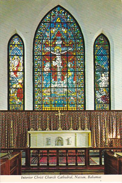
Pompey Museumis is named in honour of a courageous slave, Pompey, who lived on the Rolle Plantantion on Steventon, Exuma, Bahamas. Historic Vendue House, or the Bourse as it was known, was built some time before 1769 and continued to function as a marketplace until the late 1800s. Enslaved Africans and other commodities were sold at Vendue House during the 18th and 19th centuries. Pompey became a museum in 1992.
The Heritage Museum of the Bahamas. A rather sensationalised look at Bahamas history. $11.25
National Art Museum. In the lovely 1860 Villa Doyle, this is all Bahamian art
Balcony House (Antiquities Monuments & Museums Corporation). Housing the National Musuem of the Bahamas, it is in a lovely 2-story building with many balconies.
I caught the Westjet flight at 13:23 via Toronto and Calgary home on May 9th after a long 10 months on the road. Sandy kindly picked me up at midnight.
HISTORIC LIGHTHOUSES OF BAHAMAS Tentative WHS
Eleven lighthouses were constructed by the British Imperial Lighthouse Service (ILS) between 1836 and 1887. Prior, wrecks abounded throughout The Bahamas in the nineteenth century and concerned shipping interests implored the British to increase navigational aids in the colony. Designed by Trinity House in England, these light stations were built and manned by local British subjects, the ancestors of present-day Bahamians.
During the 1920s and 1930s, the ILS updated all of the light stations so that each had a Fresnel lens, a Chance Brothers mercury bath turning mechanism, and a mantle burning Hood Petroleum Vapor burner.
Eight were automated to solar and battery power between 1973 and 1995. All Fresnel lenses and burners were either destroyed or removed to Nassau as were some of the clock-work turning mechanisms.
These lighthouses embody the nation’s rich cultural and historical past, playing a crucial role in the development of The Bahamas and surrounding colonies.
Elbow Reef Lighthouse, on Elbow Cay, west of the harbour at Hope Town, Abaco (1864). The tower is 89 feet high and there are 101 steps up to the lantern room. The lighthouse is painted with horizontal red and white bands. This is probably the most visited lighthouse in The Bahamas.
Hole-in-the-Wall Lighthouse on the Southern tip of Great Abaco (1836) and is still active today. The name Hole-in-the-Wall referred to a limestone arch at the land’s end near the lighthouse. This lighthouse is one of the best examples of old-style British lighthouse architecture in the New World. The red and white tower stands at 77 feet and 168 feet above sea level.
Great Isaac Lighthouse (1859) is located 18 miles north of the Bimini archipelago. It has a 137-foot round cast iron tower with lantern and gallery, painted white.
Great Stirrup Cay Lighthouse (1863) is located at the Northern end of the Berry Islands. The lighthouse is a 17 m (56 ft) round stone or brick tower painted white.
San Salvador Island Lighthouse (1887) is located at Dixon Hill, San Salvador on the north-eastern side of the island. It is a 22 m (72 ft) round tapered brick tower with a lantern and gallery, painted white.
Bird Rock Lighthouse (1976), Crooked Island. It has a 30.5 m (100 ft) round tower with a lantern and gallery, painted white.
Castle Island Lighthouse (1868) is located off the southwest tip of Acklins Island. 34 m (112 ft) round brick tower painted white.
Cay Sal Lighthouse (1839) is located on Elbow Cay, at the western end of the Cay Sal Bank about 80 km (50 miles) off the Cuban coast and 130 km (80 mi) southeast of Key West, Florida. It marks the southern entrance to the Florida Straits from the Gulf of Mexico. The tower stands at 60 feet. The lighthouse was decommissioned in 1934
Cay Lobos Lighthouse (1869). Its round cast iron tower stands at 45 m (148 ft). The tiny cay is, a famous hazard to navigation, is located in the Old Bahama Channel only 50 kilometers (30 miles) off the north coast of Cuba, but it is owned by The Bahamas. For lighthouse keepers, it was the most isolated posting in The Bahamas.
Southwest Point Lighthouse (1870) is located at the southwestern tip of Great Inagua near Matthew Town. It is a round masonry tower that stands at 34 m (112 ft) with a lantern and gallery painted white.
Gun Cay (1836) is located at the south end of Gun Cay, which is less than 10 miles south of Bimini. The 77-foot round old-style stone tower is surmounted by a short square pyramidal skeletal tower. The upper half is painted red and the lower half white.
Tentative WHS: The Inagua National Park.
Islands
Acklins
Cat island
Crooked island
Eleuthera
Great Exuma
Great Inagua
Little Inagua
Long Island
Mayaguana
New Providence
North Andros
Rum Cay
Samana Cay
San Salvador island
South Andros
XL
Plana Cays
Ragged Is
Airports
Exuma (GGT)
Nassau (NAS)
North Eleuthera (ELH)
Rock Sound (RSD)
San Salvador (ZSA)
Religious Temples: Cat Island: The Hermitage
Monuments: Long Island: Colombus Monument
World of Nature
Andros Blue Hole NP
Bonefish Pond NP
Clifton Heritage
Conception Island NP
Crab Replenishment Reserve
Exuma Cays Land and Sea Park
Inagua NP
Little Inagua NP
Moriah Harbour Cay NP
West Side NP
Caves and Sinkholes: Exuma: Thunderball Grotto
Lakes: Lake Rosa
Theme Parks and Miniatures: Paradise Island: Aquaventure
Beaches: Pink Sands Beach
Well-being
Distilleries: John Watling’s Distillery
Factories: Graycliff Cigar Co
Lighthouses
Bird Rock Lighthouse
Dixon Hill Lighthouse
Great Inagua Lighthouse
GENERAL
The Bahamas is a sovereign country within the Lucayan Archipelago of the West Indies in the Atlantic. It takes up 97% of the Lucayan Archipelago’s land area and is home to 88% of the archipelago’s population. The archipelagic state consists of more than 3000 islands, cays, and islets in the Atlantic Ocean, and is located north of Cuba and northwest of the island of Hispaniola (split between Haiti and the Dominican Republic) and the Turks and Caicos Islands, southeast of the American state of Florida, and east of the Florida Keys. The capital is Nassau on the island of New Providence. The Royal Bahamas Defence Force describes The Bahamas’ territory as encompassing 470,000 km2 (180,000 sq mi) of ocean space.
HISTORY
The Bahama Islands were inhabited by the Lucayans, a branch of the Arawakan-speaking Taíno, for many centuries. Christopher Columbus was the first European to see the islands, making his first landfall in the “New World” in 1492. Later, the Spanish shipped the native Lucayans to and enslaved them on Hispaniola, after which the Bahama islands were mostly deserted from 1513 until 1648, when English colonists from Bermuda settled on the island of Eleuthera.
The Bahamas became a British crown colony in 1718, when the British clamped down on piracy. After the American Revolutionary War, the Crown resettled thousands of American Loyalists to the Bahamas; they took enslaved people with them and established plantations on land grants. African enslaved people and their descendants constituted the majority of the population from this period on. The slave trade was abolished by the British in 1807; slavery in the Bahamas was abolished in 1834. Subsequently, the Bahamas became a haven for freed African slaves. Africans liberated from illegal slave ships were resettled on the islands by the Royal Navy, while some North American slaves and Seminoles escaped to the Bahamas from Florida. Bahamians were even known to recognise the freedom of enslaved people carried by the ships of other nations which reached the Bahamas. Today Afro-Bahamians make up 90% of the population of 400,516.
The country gained governmental independence in 1973, led by Sir Lynden O. Pindling, with Elizabeth II as its queen. In terms of gross domestic product per capita, The Bahamas is one of the richest countries in the Americas (following the United States and Canada), with an economy based on tourism and offshore finance.
GEOGRAPHY
The Bahamas consists of a chain of islands spread out over some 800 kilometres (500 mi) in the Atlantic Ocean, located to the east of Florida in the United States, north of Cuba and Hispaniola and west of the British Overseas Territory of the Turks and Caicos Islands (with which it forms the Lucayan archipelago). It lies between latitudes 20° and 28°N, and longitudes 72° and 80°W and straddles the Tropic of Cancer. There are some 700 islands and 2,400 cays in total (of which 30 are inhabited) with a total land area of 10,010 km2 (3,860 sq mi).
Nassau, capital city of The Bahamas, lies on the island of New Providence; the other main inhabited islands are Grand Bahama, Eleuthera, Cat Island, Rum Cay, Long Island, San Salvador Island, Ragged Island, Acklins, Crooked Island, Exuma, Berry Islands, Mayaguana, the Bimini islands, Great Abaco and Great Inagua. The largest island is Andros.
All the islands are low and flat, with ridges that usually rise no more than 15 to 20 m (49 to 66 ft). The highest point in the country is Mount Alvernia (formerly Como Hill) on Cat Island at 64 m (210 ft).
The country contains three terrestrial ecoregions: Bahamian dry forests, Bahamian pine mosaic, and Bahamian mangroves. It had a 2019 Forest Landscape Integrity Index mean score of 7.35/10, ranking it 44th globally out of 172 countries.
Climate. The climate of The Bahamas is mostly tropical savannah climate with a hot and wet season and a warm and dry season. The low latitude, warm tropical Gulf Stream, and low elevation give The Bahamas a warm and winterless climate.
As with most tropical climates, seasonal rainfall follows the sun, and summer is the wettest season. There is only a 7 °C (13 °F) difference between the warmest month and coolest month in most of the Bahama islands.
Tropical storms and hurricanes occasionally impact The Bahamas. In 1992, Hurricane Andrew passed over the northern portions of the islands, and Hurricane Floyd passed near the eastern portions of the islands in 1999. Hurricane Dorian of 2019 passed over the archipelago at destructive Category 5 strength with sustained winds of 298 km/h (185 mph) and wind gusts up to 350 km/h (220 mph), becoming the strongest tropical cyclone on record to impact the northwestern islands of Grand Bahama and Great Abaco.
Geology. It was generally believed that the Bahamas were formed in approximately 200 million years ago, when Pangaea started to break apart. In current times, it endures as an archipelago containing over 700 islands and cays, fringed around different coral reefs. The limestone that comprises the Banks has been accumulating since at least the Cretaceous period, and perhaps as early as the Jurassic; today the total thickness under the Great Bahama Bank is over 4.5 kilometres (2.8 miles). As the limestone was deposited in shallow water, the only way to explain this massive column is to estimate that the entire platform has subsided under its own weight at a rate of roughly 3.6 centimetres (2 inches) per 1,000 years. The 6.4 km (4.0 mi) thick limestones, which predominate in The Bahamas, date back to the Cretaceous. Then, at about 80 Ma, the area became flooded by the Gulf Stream. This resulted in the drowning of the Blake Plateau, the separation of The Bahamas from Cuba and Florida, the separation of the southeastern Bahamas into separate banks, Coral reefs form the “retaining walls” of these atolls.
Coral growth was greater through the Tertiary, until the start of the ice ages, and hence those deposits are more abundant below a depth of 36 m (118 ft). In fact, an ancient extinct reef exists half a km seaward of the present one, 30 m (98 ft) below sea level. Oolites form when oceanic water penetrates the shallow banks, increasing the temperature by about 3 °C (5.4 °F) and the salinity by 0.5 percent. Cemented ooids are referred to as grapestone. Additionally, giant stromatolites are found off the Exuma Cays.[84]: 22, 29–30
Sea level changes resulted in a drop in sea level, causing wind-blown oolite to form sand dunes with distinct cross-bedding. Overlapping dunes form oolitic ridges, which become rapidly lithified through the action of rainwater, called eolianite. Most islands have ridges ranging from 30 to 45 m (98 to 148 ft), though Cat Island has a ridge 60 m (200 ft) in height. The land between ridges is conducive to the formation of lakes and swamps.[84]: 41–59, 61–64
Solution weathering of the limestone results in a “Bahamian Karst” topography. This includes potholes, blue holes such as Dean’s Blue Hole, sinkholes, beachrock such as the Bimini Road (“pavements of Atlantis”), limestone crust, caves due to the lack of rivers, and sea caves. Several blue holes are aligned along the South Andros Fault line. Tidal flats and tidal creeks are common, but the more impressive drainage patterns are formed by troughs and canyons such as Great Bahama Canyon with the evidence of turbidity currents and turbidite deposition.
ECONOMY
By the terms of GDP per capita, The Bahamas is one of the richest countries in the Americas. Its currency (the Bahamian dollar) is kept at a 1-to-1 peg with the US dollar.
The Bahamas relies heavily on tourism to generate most of its economic activity. Tourism as an industry not only accounts for about 50% of the Bahamian GDP, but also provides jobs for about half of the country’s workforce. The Bahamas attracted 5.8 million visitors in 2012, more than 70% of whom were cruise visitors.
After tourism, the next most important economic sector is banking and offshore international financial services, accounting for some 15% of GDP. It was revealed in the Panama Papers that The Bahamas is the jurisdiction with the most offshore entities or companies in the world.
The economy has a very competitive tax regime (classified by some as a tax haven). The government derives its revenue from import tariffs, VAT, licence fees, property and stamp taxes, but there is no income tax, corporate tax, capital gains tax, or wealth tax. Payroll taxes fund social insurance benefits and amount to 3.9% paid by the employee and 5.9% paid by the employer.
Agriculture and manufacturing form the third largest sector of the Bahamian economy, representing 5–7% of total GDP. An estimated 80% of the Bahamian food supply is imported. Major crops include onions, okra, tomatoes, oranges, grapefruit, cucumbers, sugar cane, lemons, limes, and sweet potatoes.
Transport. The Bahamas contains about 1,620 km (1,010 mi) of paved roads. Inter-island transport is conducted primarily via ship and air. The country has 61 airports, the chief of which are Lynden Pindling International Airport on New Providence, Grand Bahama International Airport on Grand Bahama Island and Leonard M. Thompson International Airport on Abaco Island.
DEMOGRAPHICS
The Bahamas had a population of 385,637 at the 2018 Census, of which 25.9% were 14 or under, 67.2% were 15 to 64 and 6.9% were over 65. Residents have a life expectancy of 69.87 years: 73.49 years for females, and 66.32 years for males.
The most populous islands are New Providence, where Nassau, the capital and largest city, is located; and Grand Bahama, home to the second-largest city of Freeport.
Racial and ethnic groups. 90.6% Black, 4.7% White, and 2.1% of a Mixed (African and European). Three centuries prior, in 1722 when the first official census of The Bahamas was taken, 74% of the population was native European and 26% native African.
Since the colonial era of plantations, Africans or Afro-Bahamians have been the largest ethnic group, whose primary ancestry was in West Africa. The first Africans to arrive to The Bahamas were freed slaves from Bermuda.
The Haitian community in The Bahamas is also largely of African descent and numbers about 80,000. Due to an extremely high immigration of Haitians to The Bahamas, the Bahamian government started deporting illegal Haitian immigrants to their homeland in late 2014.
The white Bahamian population are mainly the descendants of the English Puritans and American Loyalists escaping the American Revolution who arrived in 1649 and 1783, respectively. Many Southern Loyalists went to the Abaco Islands, half of whose population was of European descent as of 1985. The term white is usually used to identify Bahamians with Anglo ancestry, as well as some light-skinned Afro-Bahamians. Sometimes Bahamians use the term Conchy Joe to describe people of Anglo descent.
A small portion of the Euro-Bahamian population are Greek Bahamians, descended from Greek labourers who came to help develop the sponging industry in the 1900s. They make up less than 2% of the nation’s population, but have still preserved their distinct Greek Bahamian culture.
Religion. Protestant 80% (Baptists 35%, Anglicans 15%, Pentecostals 8%, Church of God 5%, Seventh-day Adventists 5% and Methodists 4%), Roman Catholic (14.5%), Other Christian (1.3%), Unaffiliated (3.1%), Other religion (1.1%).
Language. The official language is English. Many people speak an English-based creole language called Bahamian dialect or “Bahamianese”. Haitian Creole, a French-based creole language (25%) and is called Creole.
CULTURE
The culture of the islands is a mixture of African, British (as the former colonial power) and American (as the dominant country in the region and source of most tourists).
In the less developed outer islands (or Family Islands), handicrafts include basketry made from palm fronds. This material, commonly called “straw”, is plaited into hats and bags that are popular tourist items.
Junkanoo is a traditional Afro-Bahamian street parade of ‘rushing’, music, dance and art held in Nassau (and a few other settlements) every Boxing Day and New Year’s Day. Junkanoo is also used to celebrate other holidays and events such as Emancipation Day.
Regattas are important social events in many family island settlements. They usually feature one or more days of sailing by old-fashioned workboats, as well as an onshore festival.
Many dishes are associated with Bahamian cuisine, which reflects Caribbean, African and European influences. Some settlements have festivals associated with the traditional crop or food of that area, such as the “Pineapple Fest” in Gregory Town, Eleuthera or the “Crab Fest” on Andros. Other significant traditions include storytelling.
Sport. The national sport is cricket. The Bahamas are not eligible to play for the West Indies cricket team. The late 1970s saw the game begin to decline as teachers were replaced by teachers from the United States. Today cricket is still enjoyed by a few locals and immigrants.
The most popular spectator sports are American – basketball, American football, and baseball,
==============================================================
Bahamas – Grand Bahama (Freeport), Bimini, Berry, Great Abaco
Tentative WHS: Historic Lighthouses of Bahamas
Islands
BIMINI
World of Nature: Bimini Mangrove Forests
Villages and Small Towns: Alice Town
GRAND BAHAMA
FREEPORT
Botanical Gardens: Freeport: Garden of the Groves
Castles, Palaces, Forts: Freeport: Cooper’s Castle
World of Nature: Lucayan NP
Caves and Sinkholes: Lucayan National Park Caves
GREAT ABACO
World of Nature: Abaco NP
History, Culture, National and City Museums: Green Turtle Cay: Albert Lowe Museum
History, Culture, National and City Museums: Hope Town: Wyannie Malone Museum
Airports
Freeport (FPO)
Marsh Harbour (MHH)
South Bimini (BIM)
World of Nature: Walker’s Cay NP
Beaches
Half Moon Cay
Pig Beach
Experiences
Junkanoo
Lighthouses
Great Isaac Cay Lighthouse
Hope Town Lighthouse (Elbow Reef LH)
COVID (Published 07.02.2022 IATA Travel Centre)
1. Passengers must have a negative COVID-19 test taken at most 3 days before arrival. Tests accepted are: NAAT, PCR, RNA, RT-PCR and TMA. A rapid antigen test is also accepted for passengers between 2 and 11 years and for passengers with a COVID-19 vaccination certificate showing that they were fully vaccinated. Vaccines accepted are: AstraZeneca (Covishield), AstraZeneca (Vaxzevria), Covaxin, Janssen, Moderna (Spikevax), Pfizer-BioNTec (Comirnaty), Sinopharm (BIBP) and Sinovac. A combination of vaccines is accepted. The test must be uploaded at www.travel.gov.bs
– This does not apply to:
– passengers younger than 2 years;
– passengers with a positive COVID-19 test taken at least 14 days and at most 90 days before departure from the first embarkation point; and
– a letter issued by a health authority stating that the passenger has been cleared for travel; and
– a ‘Letter of Exemption for Travel’ issued by The Bahamas Ministry of Health or the Travel Compliance Unit.
Health and Wellness, Ministry of. (242) 502-4700 or 502-4877
