
BRAZIL – ESPIRITO SANTO (Vitoria)
From Rio, I was heading north on my quest to try to see as many Brazilian states as possible. I had booked a bus ticket to Vitoria when I walked by the Rodoviaria (Agua Branca, 215 BR, leaving at 10:20 and arriving at 06:20). I left Discovery Hostel at 9 pm but then got totally screwed by what I thought were the closest Metro Stations to the bus terminal. It turned out that that section of Line 2, the Green Line didn’t exist despite being on all the signs and route maps and in the metro cars themselves. I wasted a lot of time trying to get to the station and with only 20 minutes to departure called an Uber and just made it in time. What a fuck up.
Despite not having a bed seat, I had an above-average sleep. These buses stopped very briefly and there is no time to use an indoor bathroom. The bus arrived in Vitoria on time, I had a coffee and two smokes and booked my onward bus to Porto Seguro for 9 pm.
So I had 13+ hours to have a casual walk/bus/Uber about and see Vitoria and Vila Velha, across the bay.
ESPIRITO SANTO STATE (“Holy Spirit”), with an extensive coastline, the state hosts some of the country’s main ports, and its beaches are significant tourist attractions. The capital, Vitória, is located on an island.
History. The Portuguese arrived in 1535, and the capital was at first established in Vila Velha, but due to frequent raids by Amerindians, it was moved to the current capital of Vitória in 1551.
In 1889, Espírito Santo was made one of the states of Brazil.
During the first three centuries of Portuguese colonialism, the main cash crop was sugarcane, until coffee, in high demand in Europe, overtook it in the mid-19th century. During the colonial era, periods of gold rush occurred, when agriculture was neglected, leading to food shortages, but not as much gold was found in Espírito Santo.
It is half the size of Portugal with coastal plains, lakes, mountainous forests, mangroves, and many others.
The volcanic islands of Trindade and Martim Vaz, 715 kilometers (444 mi) east of Vitória in the southern Atlantic Ocean, are part of Espírito Santo.
Climate. Espírito Santo’s climate is tropical along the coast, with dry winters and rainy summers. North of Doce River is generally drier and also hot.
Demographics
Population over 4 million – Pardo (mixed-race) – White (50.45%), Brown (multiracial) (39.81%), 336,000 Black (9.25%), 7,000 Asian (0.19%), and 11,000 Indigenous (0.30%). About 60–75% have Italian ancestry and Germans were among the first colonists to cultivate land away from the coastal zone, and were a strong influence.
The first African slaves arrived in 1609, and years of slavery ensued.
Economy. The service sector is the largest component of GDP at 50%, followed by the industrial sector at 44%. Agriculture represents 5% of GDP (2004). Espírito Santo’s exports consisted mainly of the manufacturing of iron and steel 35.8%, iron ore 25.2%, paper 17.6%, coffee 7.7%, and granite 6.5% (as of 2002).
Tourism. A leading destination in Brazilian domestic tourism, destinations include coastal areas such as Guarapari, Jacaraípe, and Manguinhos, and mountain retreats such as Domingos Martins.
Port. Vitória’s port entrance is under the Third Bridge (the second-tallest bridge in Brazil). The port of Vitória is the most difficult to access among Brazilian ports. The bay on which it is located is extremely narrow with rocks, reefs, and mountains, making it challenging for freighters and maritime cruisers to reach the docks.
DISCOVERY COAST ATLANTIC FOREST RESERVES WHS
In the states of Bahia and Espírito Santo, there are eight separate protected areas containing 112,000 ha of Atlantic of forest and associated shrub (restingas). The rainforests of Brazil’s Atlantic coast are the world’s richest in terms of biodiversity. Species have a high level of endemism. Three national parks (Descobrimento, Monte Pascoal and Pau Brasil), two federal biological reserves (Sooretama and Una) and three special reserves (Veracruz, Pau Brasil/Ceplac and Linhares). Its biodiversity reflects longstanding ties with the major forest ecosystems of the continent, now interrupted.
VITORIA
Our Lady of Victory Cathedral. Finished in 1933, the windows were finally added in 1943. The outside is a dramatic series of spires. Inside it is a single nave church with a ribbed vaulted ceiling and 18 very large, complex stained glass windows on the sides. Three abstract red/blue/yellow windows back the altar.
Telephone Museum. Just below the cathedral, this small, private museum has telephones and an old exchange from Vitoria. Not very interesting. 10 BR
Solar Museum Monjardim. The MonJardim family ranch’s 1000s of acres grew coffee cotton, produce, and cattle. This house (built 1781-1805) is remarkably preserved and has many original furnishings giving a good look at colonial life. 20BR
Third Bridge. Crossing the harbour and connecting Victoria and Vila Velha, it has 7 huge piers in the water and many on land.
VILA VELHA*
I took a public bus to Vila Velha and then hired an Uber to take me first to the lighthouse and then to the convent. Pass Itaperica Beach.
Itaperica Beach. A huge beach a few kilometres long that was quite crowded as it was Easter Saturday.
Santa Luzia Lighthouse. At the end of the peninsular, this small white hexagonal lighthouse is not so imposing, Come here for the views with lots of whitecaps on a very windy day.
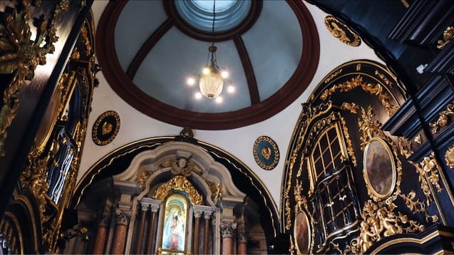
Convento da Penha. On top of a hill above Vila Velha, a chapel was built here from 1562-66 and the convent was built from 1652-66. It was a 25-minute walk up the well-graded cobbled road from the bottom. Vultures circle high overhead and roost on the rock beside the church. I was the only one walking as a van ferried people up the hill for 5 BR (Brazilians are a pretty lazy lot). From the parking area, walk up a cobbled path to the convent perched on top of a large granite rock. All white, it is a lovely small, single-nave church with gorgeous dark wood carved and embellished with flowers and ornamental designs in the pulpit, side chapel, doors, and frame around the side door. The floor was lovely inlaid wood. Gilt symbols covered the wood around the altar.
This is a very popular and one of the must-sees in Brazil. Vies down to the harbour, To Vitoria, Vila Velha, and the Third Bridge are worth the effort. a
The festival of Penha was starting the day after I arrived and lasted for a week (April 16-25).

Museu Vale. I hired another Uber to take me to the museum.
Vitoria is the 3rd largest port in Brazil and this museum details the historical significance of that. Its rail connection to the mineral wealth of Minas Gervais (iron and gold) is also showcased. 10BR
I then walked the 1.5 km back to the Rodoviaria. After an extensive search, I finally found an electrical outlet (everything needed charging) – there are 3 plugs on a small marble stand outside the fence near the Subway.
I ate at a Subway avoiding Brazil cuisine and caught my bus looking forward to a long sleep in a bed seat on my way to Porto Seguro.
==============================================================
BRAXIL – BAHIA SOUTH (Vitoria da Conquista, Itabuna)
Bahia (“bay”) is one of the 26 states of Brazil, located in the Northeast Region of the country. It is the fourth-largest Brazilian state by population (after São Paulo, Minas Gerais, and Rio de Janeiro) and the 5th-largest by area. Bahia’s capital is the city of Salvador (formerly known as “Cidade do São Salvador da Bahia de Todos os Santos”, literally “City of the Saint Savior of the Bay of All the Saints”), on a spit of land separating the Bay of All Saints from the Atlantic. Once a monarchial stronghold dominated by agricultural, slaving, and ranching interests, Bahia is now a predominantly working-class industrial and agricultural state. The state is home to 7% of the Brazilian population and produces 4.2% of the country’s GDP.
I took a 10+ hour bus from Vitoria to Puerto Seguro leaving at 9 pm, 330 BR. I had a bed seat (the first that reclined to completely flat) this time so had a good sleep.
I then had a walk about in Puerto Seguro.
PUERTO SEGURO* (Safe Harbor in English), is a city located in the far south of Bahia, Brazil. The city has an estimated population of 150,658 (2020), covers 2,287 square kilometres (883 sq mi). The area that includes Porto Seguro and neighbouring Santa Cruz Cabrália and Eunápolis holds a distinctive place in Brazilian history: in 1500 it was the first landing point of Portuguese navigators, principally Pedro Álvares Cabral. The crime rate is considered high, as is the case in the rest of Bahia
Climate. The climate in Porto Seguro is warm, pleasant, and partly cloudy. Over the course of the year, the temperature typically varies from 19 °C lows to 29C highs. The temperature in Porto Seguro varies so little throughout the year that it is not entirely meaningful to discuss hot and cold seasons.
The municipality contains the 1,151 hectares (2,840 acres) Pau-Brasil Ecological Station, a fully protected conservation unit created in 1997 to protect a fragment of Atlantic Forest, and specifically to protect Brazil wood (Pau Brasil, Caesalpinia echinata). It contains the 894 hectares (2,210 acres) Rio dos Frades Wildlife Refuge, created in 2007 to protect the mouth of the Frades River. The municipality also contains part of the Corumbau Marine Extractive Reserve, a protected offshore fishing area of 89,597 hectares.
Economy. The city is now considered one of the most important destinations of Brazil, receiving tourists from Brazil, Argentina, Uruguay, and Chile. The city and surrounding area have some luxury hotels and hundreds of smaller hotels, as well as an airport well connected with the major Brazilian cities. Apart from tourism, other important activities are agriculture (especially cashew and coconut), reforestation with eucalyptus trees, cattle, and trade and services.
The city offers one of the most famous Carnival parties in Bahia. “Electric Trios” (trucks carrying sound systems and live bands), dancing “blocos” and “cordões” (street dancing groups) drag thousands of tourists along the “Passarela do Álcool” Passageway (the traditional local avenue) and to beach bars.
Porto Seguro Lighthouse. In the Centro Hirtorico, this small white square lighthouse sits high on the edge of a cliff;. Stairs to the south (pass several stores) lead down to the highway on the water.
Epic Discovery Memorial (Memorial da Epopeia do Descobrimento) It is about the history of Portuguese colonizers in Brazil. The monument features a life-size replica of Nau Capitânia, the vessel that brought Pedro Álvares Cabral and his crew to Brazil. The museum tells the story of Brazil’s colonization with documents and artifacts and a botanical gardens and exhibits about the history of Brazil. 30 BR
it was a 1.5 km walk along the highway to the memorial.
SEE
Historical Downtown Area The historical site in the Cidade Alta area is a National Heritage Monument. It was one of the first towns in Brazil and played an important role during the first years of European colonization. It includes three churches and around 40 buildings (among private residential houses and public institutions), restored by the state government for the 500th anniversary celebration of Brazilian discovery.
The Nossa Senhora da Penha Matrix Church Located on Pero de Campos Tourinho Square, in Cidade Alta, it was built at the end of the 18th century. It comprises a nave, a main chapel, a sacristy, and a bell tower.
Monte Pascoal National Park was created in 1961 to preserve the place where Brazil was discovered by Portuguese warriors. It includes swamp areas, salt marshes, river marshes, and a coastline around the rocky, high, round hill, considered the first point of land to be seen by the Portuguese traveler Pedro Álvares Cabral’s crew. It extends over an area of 144.8 square kilometres, including the Pataxó tribe’s indigenous protection land. Besides its historical importance, it also offers protection to one of the last stretches of Atlantic forest in the Northeastern area of Brazil. The area is aimed at preserving valuable woods such as Brazil wood, and still hosts many species of animals threatened by extinction, including the collared sloth and black bear.
Recife de Fora Sea Park It was the first city-owned park in Brazil. During low tide, visitors can view a wide range of coral reefs, fish, and many sea species.
Glória Hillock These are ruins of what many consider to be the São Francisco Church, where Ynaiá, an Indian woman who died for the love of a crewmember of Portuguese navigator Gonçalo Coelho’s fleet, was buried. The São Francisco Church is said to be the first one built in Brazil in baroque style, probably in 1504, whose ruins date to 1730.
Jaqueira Indigenous Protection Reservation A huge jackfruit tree trunk, tumbled down by nature itself, represents the return to one’s origins and acts as a historical and cultural reference to honor the ancestral fathers and mothers of Pataxó families who recently moved into this 8.27 square kilometres (3.19 sq mi) Indian protection area. Their huts, spread around original Atlantic Forest woods, retain the original formats, giving visitors the impression of being back 500 years in time to pre-Columbian Brazil.
The Discovery Outdoors Museum An outdoors, natural museum, whose “art galleries” are its beaches, valleys and natural trails and whose “collection” is a set of geographical formations and traditional villages, disposed as art works in permanent exhibition, engraved in ancient media, which are spread along the 130 square kilometres (50 sq mi) length of Bahia’s historical southern coastline.
I took a bus (Brasil Bus, 20 hours, 200 BR, semi-reclining seat) to Belo Horizonte leaving at 12:45. On a Sunday, all seats were sold out on one bus line and Brasil Bus put on an extra bus leaving at 12:45 so I was lucky to get a seat. There was no reason to stay in Porto Seguro.
This was the third night in a row on a bus to see three states in Brazil.