
Brazil – Acre (Rio Branco) January 22-24, 2022
I flew from Boa Vista via Manaus and Brazilia to Rio Branco arriving after midnight and slept in the airport. Everyone wonders about Amazon deforestation. Basically, little is visible from the ground along the highways. But during my flight to Manaus and then Brazilia, there was ample evidence everywhere with big swaths of forest replaced with fields.
ACRE STATE
Acre is a state located in the west of the North Region in the westernmost part of the country, at a two-hour time difference from Brasília, Acre is bordered clockwise by the Brazilian states of Amazonas and Rondônia to the north and northeast, the Bolivian department of Pando to the southeast, and the Peruvian regions of Madre de Dios, Ucayali and Loreto to the south and west.
Its capital and largest city is Rio Branco. Other important places include Cruzeiro do Sul, Sena Madureira, Tarauacá and Feijó.
Intense extractive activity in the rubber industry, which reached its height in the early 20th century, attracted Brazilians from many regions to the state. From the mixture of sulista, southeastern Brazil, nordestino, and indigenous traditions arose a diverse cuisine.
Fluvial transport, concentrated on the Juruá and Moa rivers, in the western part of the state, and the Tarauacá and Envira rivers in the northwest, is the principal form of transportation, especially between November and June. Heavy seasonal rains frequently make the BR-364 impassable in those months; it usually connects Rio Branco to Cruzeiro do Sul.
Geography. Practically all of the terrain of the state of Acre is part of the low sandstone plateau, which dominates most of the Brazilian Amazon.
The climate is hot and very humid, and the monthly average temperatures vary between 24 and 27 °C (75 and 81 °F). The rainfall reaches an annual total of 2,100 mm (83 in), with a clear dry season in the months of June, July, and August.
The Amazon Rainforest covers all of the state territory. Very rich in rubber trees of the most valuable species (Hevea brasiliensis) and Brazil nut trees (Bertholletia excelsa), the forest guarantees that Acre is the greatest national producer of rubber and nuts. Acre’s principal rivers, mostly navigable during the wet season (the Juruá, Tarauacá, Envira, Purús, Iaco, and Acre), cross the state with almost parallel courses which converge only outside of its territory.
The largest recorded Black Caiman, measured at 7.7 meters (25 feet) and weighing 1,310 kg (2,890 lb), was shot in Acre in 1965.
History. The region of present-day Acre is thought to have been inhabited by Pre-Columbian civilizations since at least 2,100 years ago. Evidence includes complex geoglyphs of this age found in the area. The natives who crafted them are believed to have had a relatively advanced knowledge of this technology. Since at least the early 15th century, the region has been inhabited by peoples who spoke Panoan languages; their territory was geographically close to that of the Inca.
In the mid-18th century, the region was colonized by the Spanish and became part of the Viceroyalty of Peru and after 1826, part of Bolivia.
The discovery of rubber tree groves in the region in the mid-19th century attracted numerous immigrants, especially from Brazil and Europe, seeking to build on the rubber boom. Despite the increased numbers of Brazilians. After the Acre War in 1903, Brazil received final possession.
During the early twentieth century, rubber seedlings were taken to Southeast Asia, where competitive plantations were established, reducing the importance of the Amazon in production. But during the Second World War, Japanese forces took over the rubber tree groves of Malaya.
Acre was called on to produce rubber for the Allied war effort. The Rubber Soldiers, natives mostly of the Ceará plantation, increased production and provided critical supplies to the Allies.
Demographics. In 2007, there were 664,000 people: 441,000 Brown (Multiracial) people (66.5%), 172,000 White (26.0%), 45,000 Black (6.8%), 4,000 Asian or Amerindian people (0.7%).
Economy. The service sector is the largest component of GDP at 66%, followed by the industrial sector at 28.1%. Agriculture represents 5.9%, of GDP (2004). Acre exports: wood 85.6%, poultry (chicken and wild turkey) 4.7%, wood products 1.7% (2002).
Geoglyphs of Acre Tentative WHS (30/01/2015).
The Acre Geoglyphs are earthen excavated structures in the ground formed by low walls and ditches representing geometrical figures of different shapes. These enclosures are found in the southwestern region of the western Amazon, most predominantly in the eastern portion of the state of Acre, located in areas between streams, creek springs and wetlands, associated mostly with the Acre and Iquiri rivers.
Currently in the state of Acre, 306 geoglyphs type archaeological sites have been identified that are made up of 450 earthen structures.
They give important information about the management of the Amazon landscape by indigenous groups (the Arawak and Takana occupation (Manchineri, Apurinã and others) that inhabited the region between approximately 2500 BP, with construction continuing until 1000 BP. Some were still in use at the end of the thirteenth century AD and, according to recent radiocarbon dating, were re-used until as recently as the nineteenth century.
Although there is no single interpretation between archaeologists and other researchers investigating the issue on the function and use of geoglyphs, general conjectures seem to converge on the idea that these are collective social spaces for ceremonial, symbolic, ritualistic use, or even for residences. They show a great technological capacity to modify the land and floodplain environment. They are often composed of enclosures surrounded by ditches and low walls in geometric shapes with two or more structures that can be connected by straight ditches and dirt roads. Only in the Amazon such earthen structures were built in a tropical forest area by peoples who did not use metal tools. The dimensions (ranging from 10 meters to 385 meters wide, a diameter in the case of circles and sides in the case of squares) and the depth of the figures and its trenches, which are about 11 meters wide by 1.4 meters deep. These measures do not reflect the unique situation of these ditches, which today are partially covered by carried sediments that have eroded over the years. Excavations at some sites have shown that sedimentation can reach up to two meters. Originally, therefore, trenches were two or more meters deep. They can be isolated or a set of structures formed by up to six geometrical designs. They are often on the highest location and often on edges of plateaus that crown the valleys, in full view of the surroundings. In some cases, the trench has been excavated by the plateau edge. Its location in the landscape also indicates concerns with defense, suggested by the positioning of these gigantic structures in the highest possible places.
Floating over these large formations and soaking in the Amazon rainforest from a hot air balloon is a truly unforgettable experience. However, I was unable to find any tourism company offering either flights or balloon rides.

Fasendia Atlantica
I mooched the airport wifi, added posts, got the website totally up to date, and recharged my computer (a key issue).
Finally, I went outside and a car drove up dropping off a passenger. I asked for a ride into town. After mentioning breakfast, he drove me to the market in the old part of Rio Branco. A dentist, he spoke faltering English but was very kind. The market was all small eateries and was busy. I had a “typical” breakfast of hamburger/corn/tomato, eggs, cous cous and a couple of coffees. I had tons of time to kill with only the two NM sites (a museum and a bridge) to see before going to the international bus station and a 9-hour bus to Rondonia State and Porto Velho. Onward ho.
RIO BRANCO (pop 414,000). The capital of the state of Acre. Located in the valley of the Acre River in northern Brazil, The city developed from the rubber plantation founded on December 28, 1882, by migrant settlers from the Northeastern Region of Brazil. During this period of the rubber boom, there were many wealthy families in the city.
The urban elite was largely composed of liberal professionals and civil servants. The political administration of the Territory was transferred to the left bank of the Acre River, because its lands were higher and not as subject to flooding as the old city centre. The early commercial zone gradually became dominated by Syrian and Lebanese immigrants. By the mid-1930s, one area was known as “Bairro Beirut” (Beirut neighborhood).
Today, Rio Branco is seeking to find ways to reinvent itself, through relations with neighboring countries, developing heritage and eco-tourism, building on the local fish farming industry, and so on.
Economy. Historically, the economy of Rio Branco has been based on Extractivism, especially Rubber and Brazil nuts. Currently, Wood is the main product of export in the state, which is also a major producer of Açaí fruit, Copaiba oil and Meat. Rio Branco is currently undergoing a transformation in its economy; transformation that includes an expansion to Agribusiness, Aquaculture and Ecotourism.
Transportation. Rio Branco-Plácido de Castro International Airport is 18 kilometres (11 mi) away on the BR-364 highway in the rural area.
Highways. To the east, the BR-364 connects Rio Branco to Southeastern Brazil. The highway cuts west across the state, linking Rio Branco to Cruzeiro do Sul, the second major city of the state. The BR-317 has a length of 330 kilometres (210 mi), and links the capital to the south of the state, through the municipalities of Senador Guiomard, Capixaba, and Epitaciolândia, on the border with Republic of Bolivia. From Brasiléia the road continues for another 110 kilometres (68 mi) to reach the city of Assis Brasil on the border with Peru. The highway continues on the Peruvian side as part of the Interoceanic Highway[12] and as Highway 30C and Highway 26 to the city of Cuzco.
Attractions
The Rio Branco Palace was built in 1930 for the seat of the state government. The building was restored beginning in 1999 to preserve its historical character. In 2008 it was transformed into a museum of history.
Gameleira is a historical site located in the curve of the Acre River, where city was first founded. Today, more than a century later, the strangler fig located there is a vigorous tree, measuring 2.5 metres (8.2 ft) in diameter at the trunk and 20 metres (66 ft) in height.
Opened in 1958, the Cathedral of Our Lady of Nazareth was constructed in the style of an ancient Roman basilica. Its interior has three naves separated by 36 stained-glass windows, donated by families of Acre. The exterior is composed of gables, the cross, and the churchyard. In 2007 the church was considered public property of the state of Acre.
Also known as the Square of the Revolution. The Autonomists Memorial has a museum, exhibitions of paintings by regional artists, a coffee shop, and a drama theatre. The museum possesses a large collection of historic photos of the state, as well as historical objects used during the Revolution. The Museum of Rubber includes sections on archeology and paleontology, and a historical collection of manuscripts and documents relating to the history of Acre.
The Catwalk Joaquim Macedo is a pedestrian bridge linking the two districts of the city. Passing over the Acre River, the catwalk is a cable suspension bridge completed in 2006. The nearby Old Market, built in the 1920s, was recently refurbished. Maternity Park was opened on September 28, 2002. It has sports facilities, kiosks, restaurants, biking trails, and skate parks.
The incidence of poverty, as measured by the IBGE, is 37.21 per cent, and the incidence of subjective poverty is 39.39 percent.
I walked 1 km from the market to the museum. Pass Praca da Revolucao, the main square. After the museum, the boulevard continues as a park with fountains and a monument.
Memorial dos Autonomistas. In the NM Military, War, and Police Museums, in its spiffy, glass-walled 2002 home on the main plaza, this lovely museum preserves the history of the Autonomous Movement of Acre, a political movement responsible for the emancipation of Acre to the status of State. In the memorial, is the tomb of the leader of this movement José Guiomard dos Santos and his wife Lídia Hames.
Also in the building are rotating art exhibits and the “Theatro Hélio Melo” with a capacity for 150 people, it holds cultural events. It is named in honor of the great artist from Acre. There is also the “Café do Teatro”. Free
Ponte Metálica (Juscelino Kubitschek bridge). The first bridge built in Acre, is located in the center of Rio Branco and is also known as “Old Bridge” or “Metallic Bridge”. It is a one-way bridge (west to east) and has a metal plate walkway on both sides. In addition to the usefulness of connecting two districts in the capital of Acre, this ‘old lady’ has great historical importance.
In the heyday of the second rubber boom, when the capital’s ports were buzzing, it was only possible to cross the Acre River by boats, the so-called catraias. Construction of the bridge took from 1963 to 1969. In 1978, a part of the span was washed away by a flood of the Acre River and it reopened in 1985. 230 meters in length, made of reinforced concrete it is one of three other bridges over the river within Rio Branco.
I then took an Uber 5.6 km to Rodoviaria International. There are at least 4 bus lines going to Porto Velho all leaving at the same time of 8 or 9 pm. I booked a bed seat on Amatur (wifi) leaving at 9, so had 10 hours to kill. I had recently downloaded 4 books and have not read one in over a year (The Underground Railroad). I however am reading voraciously all the time – required to keep up with my subscriptions to Time, The Atlantic, and The Economist.
Acre State Nomad Mania
Serra do Divisor National Park. Tentative WHS (16/09/1998)
XL: Cruzeiro de Sul/Serra do Divisor (Acre)
World of Nature
Alto Juruá Reserve
Chico Mendes Extractive Reserve
Santa Rosa do Purus National Forest
Serra do Divisor NP
CRUZEIRO DE SUL
Religious Temples: Cruzeiro do Sul: Nossa Senhora da Gloria Cathedral
==============================================================
Brazil – Rondônia (Porto Velho) Jan 24-25 2022
RONDONIA is one of the 26 states of Brazil, located in the central-western part of the northern half of Brazi). To the west is a short border with the state of Acre, to the north is the state of Amazonas, in the east is Mato Grosso, and in the south and southwest is Bolivia. Rondônia has a population of 1,755,000 as of 2014. It is the fifth least populated state. Its capital and largest city is Porto Velho. The state was named after Cândido Rondon, who explored the north of the country during the 1910s. The state, which is home to 0.8% of the Brazilian population, is responsible for 0.6% of the Brazilian GDP.
Rondonia was originally home to over 200,000 km2 of rainforest but has become one of the most deforested places in the Amazon. By 2003 around 70,000 km2 of rainforest had been cleared.
The area around the Guaporé River is part of the Beni savanna ecoregion.
The Samuel Dam is located in the state, on the Jamari River.
Demographics. 832,000 Brown (Multiracial) people (54.81%), 546,000 White people (35.95%), 115,000 Black people (7.56%), 16,000 Asian people (1.08%), 8,000 Amerindian people (0.53%).
Economy. The economy of the state of Rondônia has, as main activities, agriculture, livestock, food industry, and vegetal and mineral extraction. Its export basket is mainly composed of frozen beef (43.43%, 14,098,031 head of cattle – 73,37% for beef and the rest for dairy), soy (32.77%), raw tin (7.08%), sawn wood (2.36%), and edible giblets (2.02%).
Beginning in the 1970s, the state attracted farmers from the south-central part of the country, stimulated by the federal government’s colonization projects and the availability of cheap and fertile land. The development of agricultural activities has transformed the area into one of the main agricultural frontiers in the country and one of the most prosperous and productive regions in northern Brazil. The state stands out in the production of coffee (largest producer in the North and 5th largest in Brazil), cocoa (2nd largest producer in the North and 3rd largest in Brazil), beans (2nd largest producer in the North), maize (2nd largest producer in the North region), soybean (3rd largest producer in the North region), rice (3rd largest producer in the North region) and cassava (4th largest producer in the North region). Despite the large volume of production and the small territory by the region’s standards (7 times smaller than Amazonas and 6 times smaller than Pará), Rondônia still has more than 60% of its territory fully preserved.
Indigenous People. As of 2011, there were 21 Indigenous Territories in Rondônia, with two more in process of being demarcated. The largest of these, the Uru-Eu-Wau-Wau Indigenous Territory, covers over 1.8 million hectares. Another, the Rio Omerê Indigenous Territory, is home to the Kanoê and Akuntsu people. Both tribes were the victims of massacres by cattle ranchers in the 1970s and 1980s and currently number just four and five individuals respectively. Over 20 indigenous languages are spoken in Rondônia.
After a 7-hour bus ride from Rio Branco, I arrived at Porto Velho. Compared to the lovely Rodoviaria International at Rio Branco (lovely, nice seating, clean), the bus depot here is a dump. The seating area was full of people sleeping all over, an almost naked guy was lying on the sidewalk moaning and shouting, several ‘homeless’ types tried to mooch money and cigarettes. The time was one hour later (5 am) and there was not much to do at this time.
PORTO VELHO (pop 539,354) is the capital of Rondônia, in the upper Amazon River basin. Located on the border of Rondônia and the state of Amazonas, the town is an important trading center for cassiterite, the mining of which represents the most important economic activity in the region, as well as a transportation and communication center. It is on the eastern shore of the Madeira River, one of the main tributaries of the Amazon River. It is the largest state capital of Brazil by area.
History. Founded by pioneers around 1907, during the construction of the Madeira-Mamoré railroad. After the railroad was completed, the local population was about one thousand inhabitants; its buildings were chiefly the railway’s installations and the wooden houses of the Caribbean (mainly Barbadian) workers – hence the name of the town’s largest district by then, “Bajan Hill” or “Barbados Town”, nowadays called the “Alto do Bode”.
During the first sixty years, the city’s development was directly connected to the railway’s activities. The town prospered during the rubber boom, but then when low-cost Malaysian rubber made rubber from the Amazon uncompetitive, the region’s economy ground to a halt. Cities like Santo Antônio do Madeira, which had a tram line and a weekly newspaper by the time of Porto Velho’s foundation, are nothing but ruins nowadays.
Porto Velho’s survival is associated with the better conditions of the area where it was built, its easy access by the river, and its harbor. With the beginning of World War II was there another cycle of progress in the region. When the Allied forces lost control over the Malaysian rubber, Amazon’s was needed due to the war effort. This produced what is known in Brazil as the “second rubber boom”. But when the war ended, the region’s economy once again came to a halt.
Porto Velho’s modern history begins with the discovery of cassiterite around the city, and of gold on the Madeira River, at the end of the 1950s. In addition, the government’s decision to allow large cattle farms in the territory began a trend of migration into the city. Almost one million people moved to Rondônia, and Porto Velho’s population increased to three hundred thousand. This intense migration caused much trouble for the city. Among many other problems, the suburban boroughs, for example, are nothing but shanty towns.
Its Catedral Metropolitana Sagrado Coração de Jesus was started in 1925
Climate is a tropical monsoon climate. The temperatures tend to be relatively consistent throughout the course of the year, between 25 and 26 degrees Celsius. The dry season is short and covers the months of June, July and August. Porto Velho is particularly wet from November through April, averaging roughly 200 mm (7.9 in) of rain per month.
Protected areas. Rio Madeira Sustainable Yield Forest (B) and (C), created in 1990; Lago do Cuniã Extractive Reserve 55,850 hectares, created in 1999; Cuniã Ecological Station, an area of savannah parkland. It holds all of the strictly protected () Serra dos Três Irmãos Ecological Station,216,000 acres. 87,412 hectares; Mapinguari National Park, a 1,776,914 hectares (4,390,850 acres) conservation unit created in 2008. It also contains part of the (546,640 acres) Jacundá National Forest, 221,218 hectares, a sustainable use conservation unit; 66% of the 197,364 hectares (487,700 acres) Jaci Paraná Extractive Reserve, created in 1996; 18,281 hectares (45,170 acres) Mujica Nava Ecological Station, created in 1996; and Bom Futuro National Forest, established in 1988. The majority of the forest surrounding Porto Velho has been cut down, however.
Porto Velho International Airport (PVH) 7 km from the city.
Porto Velho Air Force Base – ALA6, one of their most important bases of the Brazilian Air Force, is located in Porto Velho.
I called an Uber to take me around to the NM sites in Porto Velho – what a disaster. He took the wrong way to the Rondon Memorial and because of the late time, I just wanted to go to the bridge and told him so, but he drove the other way to the memorial, then up and over the bridge making a U-turn on the other side and then to the market. There was no time to eat by now, so I returned to the bus station. His charge was a whopping 168 BR.
I got to the station just in time to catch my bus to Sinop in Mato Grosso Northern State (Eucatur 510 BR, 1300 km, 18 hours).
Marechal Rondon Memorial. Resembling a huge Bororo house, the Rondon Memorial is acircular 60 metres in diameter in the middle of the Pantanal in Mato Grossoin the area where the spring of the Prata reservoirs is located. It opens to Mimoso Bay, like a stilt house allowing the water from the bay to rise so that fish and boats can access it during the flood season and, during the drought period, the animals and vegetation return.
The circular deck, is a huge open area and the mezzanine holds exhibitions, the library and the laboratory.
/s.glbimg.com/jo/g1/f/original/2016/08/09/memorialrondon_1700p.jpg)
Ponte do Rio Madeira (Ponte Rondon Roosevelt). The route to go from Rondônia to Acre, which was previously by ferry (passenger cars paying R$20 and trucks paying R$100 and taking up to 2 hours) across the Madeira River, now takes less than five minutes, over a bridge. The BR-364 bridge over the Madeira River allows production from the North and Center-West regions, mainly soybean much easier access. The concrete and steel structure is 1,517 meters long.

Mercado Cultural. Located in the center of the old Porto Velho, the Cultural Market, initially called Municipal Market, represents one of the symbols of Porto Velho. Created in 1913 in the colonial style, it housed merchandise in general, fishmongers, butchers, fruits and vegetables, but also construction material, pubs, ice cream parlors, barber shop, many delicacies such as açaí, tacacá, “ox-grated” sandwiches, hot dogs, pastries and porridges of the most varied flavors, hunting and fishing materials, wild animal skins, weapons and ammunition.
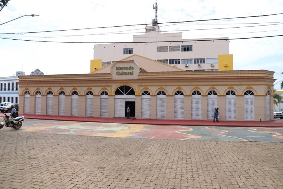
It was partially destroyed by a fire in the 50’s and was restored as a Cultural Market – a public space open to cultural arts, especially music and a meeting place for sambistas, pagodeiros, composers, artists, writers and all night owls in the city.
Museu da Memória Rondoniense (Palacio Getulio Vargas RO)On the way to Sinop we stopped in several towns to pick up and let off passengers – Aruqyenesm and Ji-Parana. Neither of these cities offer much of interest. The countryside is still Amazonas but very deforested with large fields of cattle and sparse trees.
