
BRAZIL – AMAPA (Macapa) Jan 14-15, 2022
Day 1
CAYENNE, French Guiana TO BRAZIL
Cayenne to Saint-Georges. I was thinking of hitch-hiking my Air BnB host thought it would be virtually impossible to hitch-hike in the times of COVID-19.
I caught a shared taxi in Cayenne at the ‘station’, the area where city buses start and end. The share taxis congregate across the street (and a canal) on the SW corner of Rue Paul Amulant Sant and Avenue de la Liberte. The driver was from Transport Didier, the main company that drives from Cayenne to Saint Georges (0694437851). The driver was Yohan, the owner’s son (+330664871350). We left when the vehicle was full (8 passengers) at 09:00 for the 193 km drive (2¾ hrs, 40€). The road was a shoulderless two-lane, windy affair passing through ‘bush’ of second-growth trees.
We were stopped twice, first by police and second by customs (douane). At the second, I commented on the lack of immigration at Saint-Laurant, and they said “no problem’!
Saint-Georges, on the Oyapock river, is the natural border between Brazil and French Guyana. Cross the Oyapock River on a piroque. At Saint Georges, I was advised by Yohan to not go to the police station where immigration is.
Crossing the Oyapock River. As soon as we arrived at the Oyapock River, we were hustled aggressively by several boat operators and were off in 5 minutes. The boat cruised upstream for about 3 km passing under the bridge across the Oyapock (I was told there is an immigration office here). Sitting beside me was Jukka, a Finnish guy, a wealth of information and a great help all day. He suggested that the bus to Macapa would be full and that it would be much better to take a Toyota Hilux (400 vs 137 BR, 8 hours vs 13 uncomfortable hours). The bus departed at 6 and the Hilux at 3, so I would be able to sleep in Macapa.
Oiapuque, Brazil. We mooched wifi at a hotel and I saw the monument nearby. I booked an Air BnB as there was nothing on Hostelworld or Booking.com.
It was raining heavily and we hired a taxi to do the necessary chores. I stopped at a bank and got rials.
Brazil Visa on arrival for Canadians. Covid antigen test theoretically required. At Immigration (a police station a km from the water, open 8-12 and 2-5, closed from 12-2), they asked for my vaccination card but said nothing about the Covid test (another 23€ wasted) and I got my Brazil stamp. The visa is theoretically 90 days but he asked me how long I would be in Brazil, I said 40 and he only put 40 days on the visa. I should have said longer (but doubt I will be here longer than 40 days).
OIAPOQUE* (pop 27,900)
Is a municipality in the north of the state of Amapá, Brazil. Oiapoque is also a major river in the same state, forming the international border with French Guiana. The Oyapock River Bridge, connecting the village with Saint-Georges in French Guiana, was completed in 2011 but not opened to pedestrian or vehicle traffic until 2017.
Lying on the northern coast of Brazil, Oiapoque is popularly considered the northernmost point of Brazil. The phrase do Oiapoque ao Chuí (“from Oiapoque to Chuí”) means “all of Brazil.” However, there are more northerly points in Roraima state such as the municipality of Uiramutã. Oiapoque remains the northernmost coastal city of Brazil, and the northernmost city of Amapá. It occupies more than half of the north border of the state.
Clevelândia. At the beginning of the 20th century, the village of Oiapoque hosted a political and criminal concentration camp called Clevelândia (1922–1926). Many Brazilian anarchist militants were sentenced to hard labour here. Of the 946 prisoners interned at Clevelândia between 1924 and 1927, 491 died. Many of the survivors returned to São Paulo and Rio de Janeiro permanently sickened with malaria.
Geography. Oiapoque is bordered to the west by its long frontier with French Guiana. It is bordered to the north by the Atlantic Ocean.
Amapá State Forest, a sustainable use conservation unit established in 2006. The Cabo Orange National Park is located on the coast of the municipality, and covers 6,573 square kilometres (2,538 sq mi) of rainforest on the coast line.
Oiapoque can be accessed by air via the Oiapoque Airport.
Climate. Oiapoque has a tropical monsoon climate (Am) with moderate to little rainfall from August to November and heavy to very heavy rainfall in the remaining months.
Monumento Extremo (in French Guiana – Cayenne)
Kuahi Museum. Opened in 2007 by the four indigenous groups living in the municipality: the Palikur, the Galibi Marwono, the Galibi do Oiapoque, and the Karipuna do Amapá to promote and transmit the knowledge of the indigenous community. The museum contains more than 400 objects used by the Amerindians.
Oiapuque to Macapa. Jukka spoke fluent Portuguese and arranged the Hilux driver to meet us at the bus station. It was a 600 km drive to Macapa, the first 3 hours on slow, packed dirt and potholes, then 7 more on good pavement. The Hilux was in terrible condition. We were stopped at a police stop and the driver was fined 5,000 BR (~US$1,000 ouch). We arrived at 1 am and I checked into my hotel. No problem.
Jukka said it would be very difficult to get a SIM without a Brazilian ID card. He gave me the second SIM from his phone. This was the simplest way to get a SIM ever. Jukka made my day.
Day 2
MACAPA/SANTANA is a major city, it’s where the Amazon river meets the Atlantic Ocean. In addition, it’s also located on the equator meaning it’s very hot!
I stayed at the Hotel Amazonas, a budget hotel downtown. I had a very drab room only with a fan. But it was adequate, very cheap and provided breakfast.
In the morning I had a walkabout after catching a city bus to Zero (about 8 km from downtown).
Marco Zero. Ground Zero Ecuador – Half The World. This location is perfect for making Instagram snaps with one foot in the Southern hemisphere and the other in the Northern.

Zerão (Stadium in two hemispheres, Macapa Football Stadium). In the NM Bizzarium series, it is unique as it has been built on the equator. It’s a short walk from the Marco Zero monument. The centerline of the pitch is located on the equator. As a result, one team is playing in the northern hemisphere and the other team is in the southern.
Covid Booster. Just outside the stadium was an outdoor, mobile vaccination site. I asked if I could have my booster. No problem and free, took 5 minutes.
Trapiche Eliezer Levy and Macapa Promenade. There is a promenade alongside the beach which is probably best walked on during the early morning or evening (due to the heat during the day). On the promenade, you’ll pass Trapiche Eliezer Levy which is a long pier as well as a good place to watch the sunset.
Museu Histórico Joaquim Caetano da Silva. The local municipal museum with the history of the city. Free
Fortaleza de São José de Macapá. It was built by the Portuguese in the eighteenth century to protect the Amazon. Most importantly, to protect it from the French who weren’t too far away in French Guiana. The city of Macapa was founded in 1758 and just 6 years later the construction of the Fort began. The fort is large from the outside with 4 large corner ravelins. Inside the walls are lined with buildings and there are 8 buildings surrounding the middle square. Free
Outside the Fort is a beautiful park with greenery, flowers and a wonderful view of the Fort itself.
Sacaca Museum. This is a lovely open-air ethnography museum with various “exhibits” set in a lovely forest with elevated walkways. There is a floating market (river boat), several indigenous houses (Plikui, Nut gatherers, Wayapi), Riverside), and demonstration houses (cassava flour, midwives, and creation). Free
Day 3
I flew from Macapa to Belem on Gol Airlines. The 8 pm flight was delayed to 01:30 am!! I slept in the airport as well as I could for a few hours.
==============================================================
BRAZIL – PARA COASTAL (Belém, Porto de Moz, Bragança) Jan 15-17, 2022
BELEM/ANANINDEUA/ABAETETUBA (pop 1,499,641 metro area)
Portuguese for Bethlehem; is a Brazilian city, capital, and largest city of the state of Pará in the country’s north. It is the gateway to the Amazon River with a busy port, airport, and bus/coach station. Belém lies approximately 100 km upriver from the Atlantic Ocean, on the Pará River, which is part of the greater Amazon River system, separated from the larger part of the Amazon delta by Ilha de Marajó (Marajo Island). It is the 11th most populous city in Brazil, as well as the 16th by economic relevance. It is the second largest in the North Region, second only to Manaus, in the state of Amazonas.
Founded in 1616 by the Kingdom of Portugal, Belém was the first European colony on the Amazon but did not become part of Brazil until 1775. The newer part of the city has modern buildings and skyscrapers. The colonial portion retains the charm of tree-filled squares, churches, and traditional blue tiles. The city has a rich history and architecture from colonial times. Recently it witnessed a skyscraper boom.
Belém is also known as the Metropolis of the Brazilian Amazon region or the Cidade das Mangueiras (City of Mango Trees) due to the vast number of those trees found in the city. Brazilians often refer to the city as Belém do Pará (“Belém of Pará”) rather than just Belém, a reference to an earlier name for the city, Santa Maria de Belém do Grão Pará, and also to differentiate it from a number of other towns called Belém in Brazil, as well as the city of Bethlehem in the West Bank of Palestine. It is named after Santa Maria de Belém in Lisbon, also better known by its shortened name, Belém.
Belém is served by two airports: Val de Cans International Airport, which connects the city with the rest of Brazil and other cities in South America, North America (USA) and Europe (Lisbon) and Brig. Protásio de Oliveira Airport (formerly called Júlio César Airport) dedicated to general aviation. The city is also home to the Federal University of Pará and the Pará State University.
History. In 1615, Portuguese captain-general Francisco Caldeira Castelo Branco of the captaincy of Bahia commanded a military expedition sent by the Governor-General of Brazil to check the trading excursions of foreigners (French, Dutch, English) up the river (Amazon) from the Cabo do Norte in Grão Pará.
On January 12, 1616, he anchored in what is now known as Guajará Bay, formed by the confluence of the Para and Guama Rivers, called by the Tupinambás, “Guaçu Paraná”. Caldeira mistook the bay for the main channel, and thirty leagues (178 km) upstream, he built a wooden fort, covered with straw, which he called “Presépio” (nativity scene), now known as “Forte do Castelo”. The fort failed to suppress Dutch and French trading, but did ward off colonization.
Feliz Lusitânia was later called Nossa Senhora de Belém do Grão Pará (Our Lady of Bethlehem of Grao-Para) and Santa Maria de Belém (St. Mary of Bethlehem). Belém was given city status in 1655. The early decades of the 19th century were marked by political instability. Uprisings and internecine strife finally ended in 1836, after considerable loss of life.
The sugar trade in the Belém region was important up to the end of the 17th century. Thereafter the city’s economic importance alternately rose and fell. Cattle ranching supplanted sugar until the 18th century when the cultivation of rice, cotton, and coffee became profitable. With the settlement of southern Brazil, where such crops could be produced more efficiently, Belém declined again. The city subsequently became the main exporting centre of the Amazon rubber industry, and by 1866 its position was further enhanced by the opening of the Amazon, Tocantins, and Tapajós rivers to navigation. The rubber era ended after the boom of 1910–12, but Belém continued to be the main commercial centre of northern Brazil and the entrepôt for the Amazon valley.
Geography. These include the islands of Mosqueiro, fringed by 14 freshwater beaches, and Caratateua which receives a large number of visitors in the summertime. In addition to these and also near Belém, is the island of Tatuoca which is the location of one of the seven geophysical stations in the world, and the only station in Latin America.
Climate. Belém has a tropical rainforest climate with no cyclones, that is a true equatorial climate. In all 12 months of the year, the city on average sees more than 60 mm of rainfall, so the city has no true dry season month. The wetter season spans from December through May Average temperatures vary little throughout the course of the year, generally hovering around 26.5 degrees Celsius.
The Amazon represents more than half the planet’s remaining rainforests and comprises the largest and most species-rich tract of tropical rainforest in the world. Wet tropical forests are the most species-rich biome, and tropical forests in the Americas are consistently more species-rich than the wet forests in Africa and Asia. As the largest tract of tropical rainforest in the Americas, the Amazonian rainforests have unparalleled biodiversity. More than one-third of all species in the world live in the Amazon Rainforest.
Economy. Many valuable products now exported from the Amazon by way of Belém are aluminum, iron ore, and other metals, nuts (chiefly Brazil nuts), pineapples, cassava, jute, wood veneers, and hardwoods. Japanese immigration after the 1930s was an important factor in developing jute and black pepper, notably at Tomé-Açu, just south of Belém, and near Santarém. Marajó Island, the largest fluvial island in the world, which lies just across the Rio Pará from Belém, has some livestock grazing. Electricity is provided by the massive Tucuruí Dam, some 300 km southwest of the city on the Tocantins River.
Demographics. In 2018, there were 2,491,052 people residing in the Metropolitan Region of Belém. This region is composed by 7 cities: Belém (1,485.732 people), Ananindeua (525,566 people), Marituba (129,321 people), Benevides (61,689 people), Santa Bárbara do Pará (20,704 people), Santa Izabel do Pará (69,746 people), and Castanhal (198,294 people). 1,379,655 Pardo (Multiracial) people (64.5%), 588,225 White (27.5%), 156,147 Black (7.3%), 14,973 Asian or Amerindian people (0.7%).
According to an autosomal DNA genetic study from 2011, the ancestral composition of the population of Belém is: 68.6% European ancestry, followed by 20.9% Amerindian ancestry and 10.6% African ancestry.
I arrived in Belem at 3 am, got an Uber ride to my hostel and was able to wake up the night guy working. There were no male dorms to book on Hostelworld, so I had erroneously rented and paid for a 4-person private. It was corrected to a one-person rental in the morning and then I was given a bed in the mixed dorm, saving 150 BR.
I got up late and went for a lovely walkabout in Belem taking up most of the day. It was a cool 28° and quite tolerable. There were two torrential thunderstorms during the day.
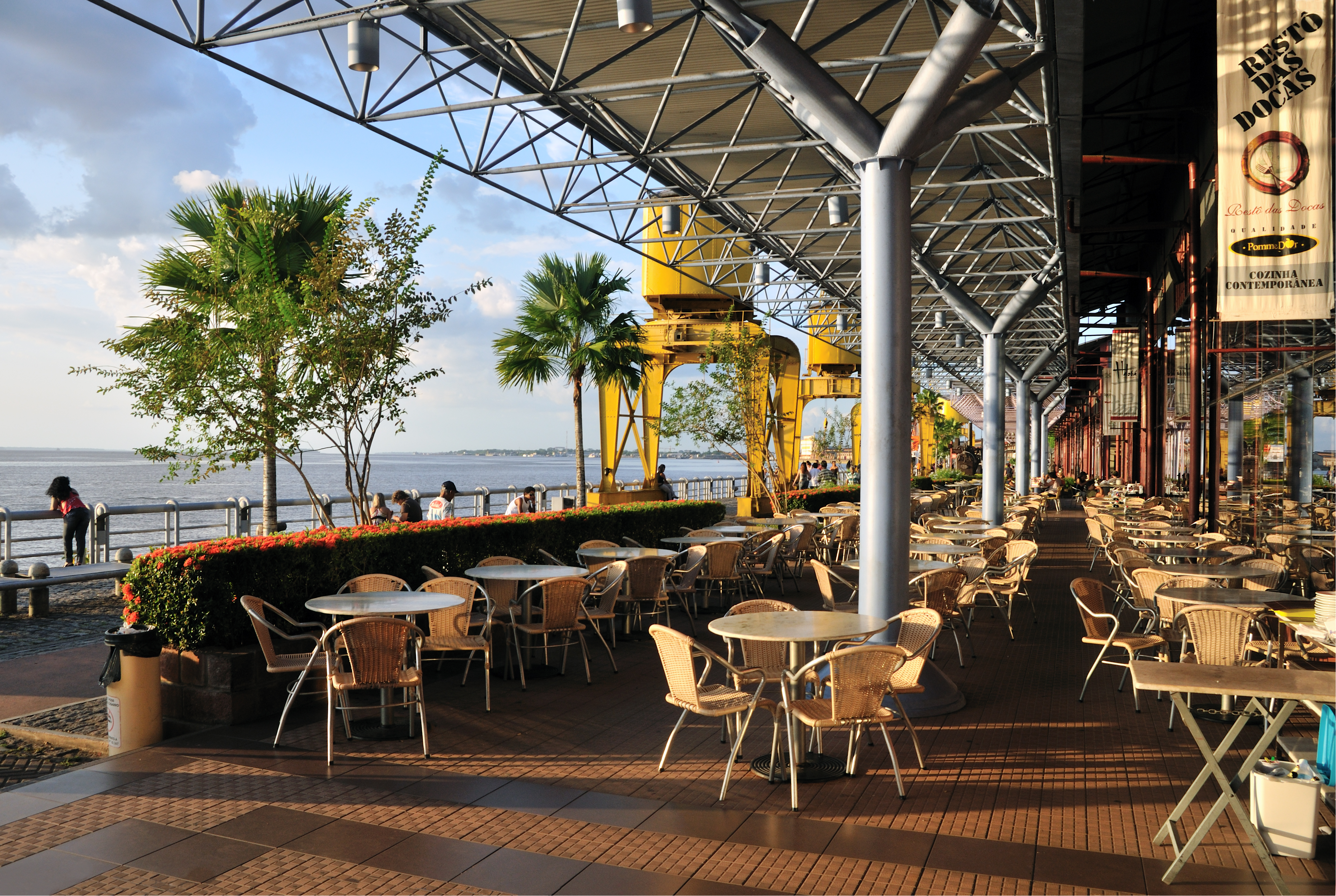
Estação das Docas. (NM Urban Legends series). This is the old port area of Belem – on the waterfront (the Para River branch of the Amazon), all the old loading cranes have been left on their tracks and the warehouses converted into restaurants with lovely large indoor seating areas and sidewalk cafes.
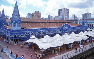
Ver-o-Peso Tentative WHS (27/02/2014) market is a market hall in Belém, Brazil located at Guajará Bay riverside. It is called “Ver-o-Peso” following a colonial-era tradition since the tax collector’s main post was located there, which was called “Casa do Haver-o-peso” (“Have-the-Weight House”). It was in the “Haver-o-peso house” that the taxes over goods brought from the Amazon forests, rivers, and countryside should be paid to the Portuguese crown, but only after their weight was measured, hence the name, which later suffered a contraction.
Nowadays, the Ver-o-peso complex contains the Açaí Fair, a free open market where açaí berry merchants sell the fruit in nature for açaí juice shops, the Clock Square, with an iron-cast clock tower brought from England, the Ver-o-peso docks, where native fishes from Amazon are unloaded from boats and sold fresh, the Iron Market, a gothic prefab structure where fish is sold, the Solar da Beira space, a colonial building where art expositions often take place, and the neoclassical Meat Market, across the street, with iron-cast stairs and cubicles. There’s also the free market, where craftsmanship, natural essence perfumes, typical food, and native fruits are sold.
It is located a few meters away from Feliz Lusitânia complex, a gathering of 16th and 18th-century buildings including a fortress, an old hospital transformed into a museum, and two churches: a baroque one where there is a sacred art museum, and Belém’s cathedral.
All this area has been declared national patrimony by the National Historical Museum (Brazil).
“The Ver-o-Peso market is a must-see in Belém and a trade spot dating back to the 18th century. Its four-towered iron building is for Belém what the statue of liberty is to New York. The movement in the market starts early in the morning before the sun comes up. You can see açaí and fishery arrive from the islands through the river. You can buy all kinds of herbs, fruit and bottled spells in the market and also find typical foods like vatapá, maniçoba and açaí with fried fish or shrimp for fair prices. On Sundays and Saturdays, it is a nice place to have a traditional lunch listening to samba or the local rhythm called carimbó. The bad part is that the market is not a safe place to take valuables like jewellery and electronics. Keep an eye for pickpockets.”
Forte do Presépio. The city of Belém was founded in 1616 with the construction of this imposing fort, which was intended to protect Portuguese interests upriver from incursions by the French and Dutch. Today it houses a small but excellent museum, primarily about Pará state’s indigenous communities (displays in Portuguese only), and has great river and city views from atop its thick stone walls. 4 BR

Museu de Arte de Belém MABE. In a late neoclassical building with Tuscan columns, triangles, and symmetry on the facade. Inside, there are neo-Greek staircases in lioz marble, two patios, and the great halls. The Belém Museum of Art was established in 1991 to display the works by local, national, and foreign artists, Brazilian furniture from the 19th and early 20th centuries, photographs, ceramics, interior objects, and sculptures.
Palácio Antônio Lemos is the result of the Era of Rubber in the second half of the 19th century when the Amazon had great economic development. Antônio Lemos was the Intendant of Belém from 1897 to 1911 and the main person responsible for the process of re-urbanization and modernization of the city.
Para State Museum. Housed in the grand Palácio Lauro Sodré, originally the residence of Portugal’s royal representatives in Belém and later home to various state governors, one such governor, Ernesto Lobo, was killed on the staircase during the Cabanagem Rebellion in 1835. The museum today is less thrilling, with a vaguely interesting collection on the founding and growth of Belém and Pará.
Corveta-Museu Solimões. Maritime/Ship Museums. It is a corvette, currently a museum ship, of the Brazilian Navy. It was built in Rotterdam and delivered to the Brazilian Navy in 1955. From 1955 to 1959, it was used in sweeping, mining, coastal patrol missions, and providing maritime rescue services. Since then it was used for unloading and towing of ships, patrol (including borders), maritime assistance (search and rescue), transport of troops, and in actions of civic and social assistance with the riverside populations of the Amazon, transporting supplies and providing medical and dental care.
Since 2008 the renovated vessel has been a museum ship. 55.72 meters in length, 9.55 meters in breadth. Crew: 61 men, 6 officers and 55 soldiers. Free
Mangal das Garças. (NM Urban Legends series). This is a lovely urban park with a little bit of everything – nice trees and grass, ponds and fountains. roaming egrets and birds, a zoo, a lighthouse that can be climbed and several restaurants. 15 BR for all the attractions or buy each one separately.

Basilica of Our Lady of Nazareth of Exile is a Catholic temple started in 1909 at the place where the image of the Virgin of Nazareth was found by Plácido José de Souza (whose origins are controversial, with different versions).

Museo Paraense Emilio Goeldi Natural History and Earth Museums is a research institution and museum founded in 1866 as the Pará Museum of Natural History and Ethnography and was later named in honour of Swiss naturalist Émil August Goeldi, The institution has the mission of researching, cataloging and analyzing the biological and sociocultural diversity of the Amazon Basin employing its museums, botanical garden, and zoological park.
The Museum maintains a scientific research station in the high Amazon forest. The botany section works in taxonomy and systematics of the Amazon flora, plant biodiversity, and the structure and dynamics of rain forests with a botanical garden and more than 200,000 specimens of seeds, fruits, woods, pollen, histological sections and exsicata. In zoology, the Museum does research on the Amazon fauna, and the collections include around 150,000 specimens of vertebrate whole bodies. The paleontological collections have more than 6,000 species, and the mineralogical collections have more than 1,000 samples.
Also covered are the pre-history and contemporaneous history of human populations in the Amazon with more than 120,000 pieces in the archeological collection
Palacete Bolonha. In the NM House and Biographical Museums series, this palace was built in 1905 by the engineer Francisco Bolonha as a gift to his wife Alice Tem-Brink. It is a symbol of the Belle Époque of Belém characteristic of the era of the rubber boom mixing neoclassical, art nouveau, baroque and rococo styles.
It has five floors, with a ground floor, lounge, social area, bathrooms and bedrooms, and a facade that measures almost twenty meters in height. Full of multiple internal divisions and decoration loaded with gilt and stucco plus art nouveau mosaics with reproductions similar to those of Pompeii, Greco-Roman-themed reliefs, glass floors and a variety of other coverings.
Inside, the walls are smooth plaster, white or decorated tiles, wood, tile, and even ceramic panels. Stucco forms decorative wreaths of flowers, panels with nymphs and angels, a lion’s head, and wooden floors of yellowwood and acapu wood, with inlays or patterns. The ceilings, most are in stucco, but also paintings simulating wood, decorated tiles or metal plates.
The residence was equipped with the most modern electrical and hydraulic installations available at the time – copper conduits, circuit breakers, sockets and switches, cold and hot water, flushing boxes, siphons, toilets and urinals, and piped gas.
It was completely restored and opened in 2020,

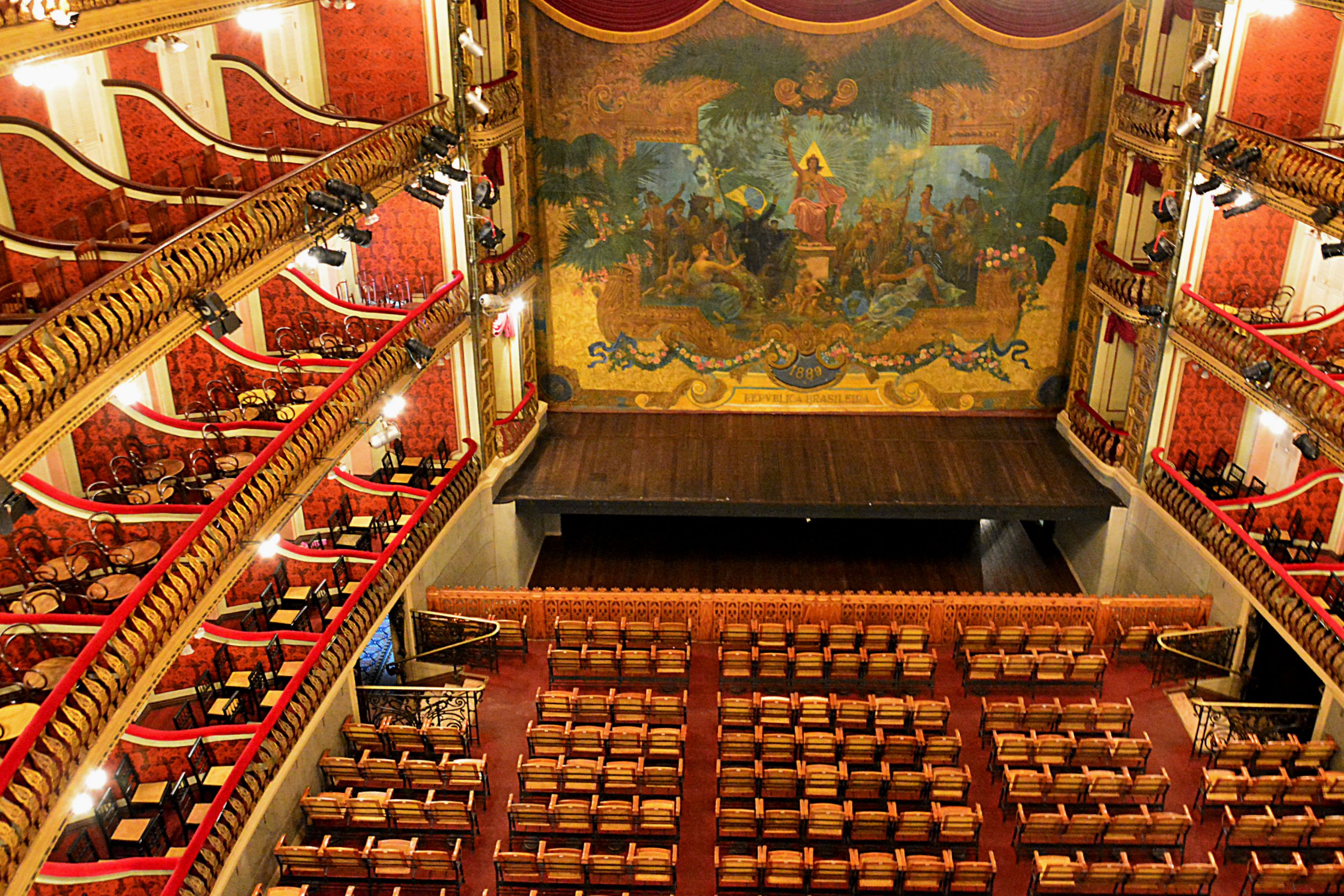
AMAZONIA THEATRES Tentative WHS (30/01/2015)
Teatro da Paz (Paz Theater)
One of the examples of neoclassical architecture in Brazil and the first show house of monumental character in the northern part of the country, the Teatro da Paz was erected in 1874 with an original project by José Tibúrcio de Magalhães. He presented an opera house typology, with the audience in a horseshoe shape, with an orchestra pit, proscenium, and curtain.
For the theatre beautification, the local government undertook the first reform carried out between 1887 and 1890, where they contracted services for the painting of the concert hall and auditorium, by the Italian artists from the Roman Academy of San Luca, Domenico De Angelis and Giovanni Capranesi. The beautiful ceiling, painted by De Angelis, with light effects and sinuous shapes and the Baroque style, offers idyllic scenes with characters from Greek and Roman mythology, with representations of Amazonian Indigenous Peoples.
Another important artist in this intervention was the Brazilian Crispim do Amaral, hired to paint the stage curtain made in Paris by set designer Eugène Carpezat. This being the first Republican artistic representation of the state of Pará, alluding to the Allegory of the Republic, an oil painting that brings Marianne, the traditional representation of the French Republic, to the center amid mestizos, native inhabitants, mulattos, and Greco-Roman mythological characters.
In 1904, in the prime of the Amazonian Belle Époque, during the government of Augusto Montenegro and the Municipal Commissioner Antonio Lemos, the theatre underwent further intervention incorporating the luxurious interior design, the taste of eclecticism, which remains to this day. The facade has been redesigned to meet the classical standards, the electric lighting system has been improved, in addition to the refined and integrated furniture that are incorporated into the environment, including hardwood floors in the area, wall coverings decorated with metal sheets, statues made in Carrara marble in Paris, representing Gonçalves Dias and José de Alencar, two representatives of the romantic literature canon, installed in hallways, caryatids in “Tercé stone”, iron bars and bronze made in Paris, as well as chandeliers and crystal chandeliers highlighted by the concert hall luster acquired from the United States of America. It should also be noted that the auditorium additionally received, among other elements, the busts of the Brazilian maestros Carlos Gomes and Henrique Eulálio Gurjão, made in Genoa, Italy.
Due to its condition, which inspired care, in 2000, 2008, and 2010, some improvements were undertaken for the modernization of the infrastructure, occasion in which the electrical and hydraulic installations were recovered, with internal adjustments of use being made, along with the structural strengthening of the roof, and the restoration of all integrated artistic property.
COVID AT HOME (Jan 15, 20220 – British Columbia Canada. BC may have reached its peak level of COVID-19 infections during the Omicron wave in mid-January and infection rates are now on the decline. The worst is still yet to come for BC’s already weakened healthcare system – hospital admissions are expected to peak with about 250 new daily admissions per day. At the previous peak of COVID hospitalizations in April 2021—there were 515 people in hospital. Currently, there are 646 people in hospital up from 220 on Dec. 31. There were 21,517 healthcare workers out sick between Jan. 3 and Jan. 9. The virus poses much higher risk to unvaccinated people: compared to those who’ve had two doses of vaccine, unvaccinated people are 12 times more likely to be hospitalized, 27 times more likely to need ICU care, and 40 times more likely to die of COVID-19.
Double-vaccinated people—and particularly among those aged 70 years and older, are at a spike in hospitalizations. This includes children. In the past week, 9 kids under age 4, 2 kids aged 5-11, and 2 kids aged 12-17 were admitted to hospital due to COVID-19. Of those, none have needed ICU care.
==============================================================
BRAZIL – PARA INLAND (Santarem, Altamira, Maraba)
Day 4, 5, 6
On January 17, I flew on Azul Air from Belem to Santarem, Para Inland state arriving at 1:55, got my luggage, and tried to find a taxi into town. There was no Uber and I ended up talking to a guy going into town. He sells medical supplies throughout northern Brazil and was here to set up a new outlet. I caught a ride into town with him and I explained my travel. I wanted to be let off at the Enasal office, the company that offers boat trips up the Amazon to Manaus. I had been trying to connect with them by email and phone but had no luck. Their website states that boats leave daily and take about 36 hours from Santarem. The taxi driver pulled over near the Enasal office and talked to a guy on the Malecon. Within minutes, I was in a speedboat trying to catch the Enasal ferry that was cruising by out in the middle of the Amazon. It soon disappeared out of sight behind an island but we caught up to it, it slowed down and I climbed on board. The guy in the boat wanted 250 BR. That was 3:06 pm.
The boat is run by Enasal and is the Navegacao Ana Beatriz. The bottom deck was full of cars, bananas, and other produce. The first deck had about 160 hammocks slung out cheek to jowl in four rows but all were occupied. Everyone’s luggage was on the deck below them. I wandered up to the second floor where there were another 100 hammocks. Most of the hammocks had people sleeping on them. I went to the bridge and a guy asked if I had a hammock. Of course, I didn’t but I have a sleeping pad that I could lay out anywhere. He didn’t seem to care where I put it and I wanted it to be where there was a breeze. The top deck is completely open and empty except for the frame for a small tent. That is where I will probably sleep.
The cost of the ferry to Manaus was 150 BR (US$30) and takes about 50 hours. With the exorbitant speed boat ride, I would get to Manaus exactly how I wanted to for a fraction of the cost of a plane (400 BR equals about US$80). Taking the highway is a big trip as the highway goes a longways south to get around all the water, heads west, and then turns north to reach Manaus. The scene out the window would be monotonous bush and at this time of the year in the rainy season, prone to being blocked by floods.
I put my pack next to the outside wall on the second deck, bought a beer, and ensconced myself on a bench with a bunch of nice Brazilians enjoying themselves drinking beer, my computer plugged in and all set to go. I have wifi tethered to my smartphone network, but am soon out of reach of a signal. I recently downloaded four books from Amazon so have lots to read and my book on Asperger’s to finish. Too funny.
I have lots of cash to get by, the beer is cheap and I assume with this crowd, the food is too.
I have always believed I am the luckiest person (maybe not in love but in everything else). This is just one more example. Santarem had nothing to see (the only NM site was the Santarém Museum, which after several attempts, I couldn’t find it. It was probably closed anyway). I was only there to collect another NM region (Para Inland). If I were stuck there for a few days, I thought I would go to Fordlandia, a NM Bizzarium site 180 km south of Santarem. But it would otherwise be deadly boring. A couple of nights in a hotel would be well over $80.
As things progressed, one guy (the comedian of the group) bought me a beer and seemed intent on hooking me up with the woman sitting next to me. They had lots of laughs. They were all very pleasant. I doubt that anyone on the boat speaks English.
Nice fast Brazilian music is playing in the background. There are two tables of dominoes going. This appears to be a simplistic game, made enjoyable by everyone slapping down the dominoes with gusto and betting. One older guy asked me to play, but I don’t think I could tolerate its simplicity. I have chosen the right bunch to be sitting next to.
Even under the deck, it is steamy hot but quite manageable at 27 and sunny. The Amazon here is muddy brown and very wide. I guess it must be at least 2 km between the shores. The nearshore is fields and second-growth bush. The Amazon has many channels with islands in the middle.
It is not uncommon for some travellers to have their dream trip of taking the Amazon to its mouth. I always thought this would be deadly boring and it would be, only made tolerable with a lot of beer and a fun crowd. A comparable trip (that I have done) is the Trans-Siberian Railway – 74 hours of the same scene – not a hill, birch trees, ugly Soviet cities, and impoverished farms – all made tolerable with a lot of vodka and people to party with. But it is also very expensive, not at all like this trip.
At sunset (7 pm), we passed a village of houses on stilts and dependent entirely on boat access. A lightning storm in the northeast provided pyrotechnics. I was feeling very knackered early and went to sleep at 8:30 on the top deck, now full of people, but with an area in front. Supposedly forbidden, a crew member told me that I would get cold and it would rain, but finally let me be. Someone came and woke me at 01:45 to warn me of impending rain and I moved undercover. The dominoes game was still going. The rain started at 2 and everyone went to bed.
At 3 am, we stopped at the town of Juruti and picked up passengers. I gave a guy some money to get some smokes, he ran like hell but didn’t make it back before we left. Oh well.
The Enasal Expresso Ana Beatriz caught up to us and let off a passenger. This must be the nine-hour daily trip between Santarem and Manaus.
At 08:30, we passed Parintins, a fairly large town on the south bank of the river. We stopped here for at least 3 hours and unloaded all the fruit (bananas, plantains, apples, grapefruit), vegetables (onions, potatoes, cabbage), and a whole bunch of chairs from the boat.
The river continues to be a muddy brown and at least 2 km wide. During the day, there were multiple rainstorms. I started playing rummy in the late afternoon and stayed up till 1 am. It was fun. At 2 am, we had another stop at Itacoatara for over an hour.
On Wednesday morning, a man came up to me and demanded I pay for the boat. I had already paid 150 BR to a man on the bridge but was not given a ticket or wrist band. He kept talking to me in Portuguese despite me asking him several times to use Google Translate. It got ridiculous and finally told him to f**k off. Then a woman explained the situation and told me that I had paid a ‘mafioso’. I went to the bridge to talk to the captain and asked if they allowed mafioso on the bridge just waiting to swindle the only person on the boat who arrived this way. He was unable to help. It appears that the person demanding the money who refused to use GT was also a mafioso!! It was all crazy and remains unresolved. I refused to pay again.
Just before disembarking at 3 pm on Jan 19th, I was ushered down to the accounting office where I finally got to talk to Mr Santander, who spoke faltering English, but also most of anyone on the boat. I explained the whole episode and that the guy I paid was standing in the bridge. I wondered why nobody had met me when I jumped on the boat that had slowed down considerably to let me on. He was very understanding and didn’t know the fellow who had tried to make me pay but wouldn’t use Google Translate (and was a ‘mafiosa’ too). He was very understanding and ended up not charging.
FORDLANDIA. In the NM Bizzarium series, this is a district and adjacent area of 14,268 square kilometres (5,509 sq mi) in the city of Aveiro, in the Brazilian state of Pará. It is located on the east banks of the Tapajós river roughly 300 kilometres (190 mi) south of the city of Santarém.
It was established by American industrialist Henry Ford in the Amazon Rainforest in 1928 as a prefabricated industrial town intended to be inhabited by 10,000 people to secure a source of cultivated rubber for the automobile manufacturing operations of the Ford Motor Company in the United States. Ford had negotiated a deal with the Brazilian government granting him a concession of 10,000 km2 (3,900 sq mi) of land. The agreement exempted Ford from taxes on the exportation of goods produced in Brazil in exchange for 9% of the profits, 7% going to the Brazilian government, and 2% of profits to local municipalities. Ford’s project failed, and the city was abandoned in 1934.
The town was mostly deserted, with only 90 residents still living in the city until the early 2000s when it saw an increase in population, being home to around 3,000 people as of 2017.
Background. In the 1920s, the Ford Motor Company sought to elude the British monopoly over the supply of rubber, mainly used for producing tires and other car parts. Henry Ford looked for alternatives and a permanent place to establish a colony to produce rubber. Central America was considered; however, information about the rubber trees in the Amazon was uncovered, and this, along with other factors, caused a change of plans.
Negotiations with the Brazilian government started during the visit by the then-governor of the State of Pará, Dionísio Bentes, to the United States to meet Ford. An agreement was signed and the American industrialists received an area of about 2.5 million acres (10,100 km2) called “Boa Vista”.
History. Work on the area began in 1926 by the Companhia Ford Industrial do Brasil. It was immediately hindered by poor logistics and diseases that affected the workers who succumbed to yellow fever and malaria. No roads were available in the area thus the area was only accessible by the Tapajós River. The site was developed as a planned community with different areas of the city being designated for the Brazilian workers and the American managers, who lived in the so-called American Village. Typical American houses were built, as were a hospital, school, library, and hotel. The town also had a swimming pool, a playground, and a golf course.
In 1928, the Ford Motor Company sent two merchant ships – Lake Ormoc and Lake Farge – loaded with equipment and furnishings ranging from doorknobs to the town’s water tower. The town was then founded under the name Fordlândia.
Seeking workers, several offices were opened in the cities of Belém and Manaus, and, with the promise of good wages, people of the nearby states answered.
In lower temperatures the latex is concentrated in the lower areas of the tree, as the temperature rises during the day the latex spreads throughout the tree, making the tapping less effective. Due to this, the typical journey of a rubber tapper began early in the morning, at around 5 am, ending at noon. The plantation was divided into areas and each worker was assigned to a different area to prevent workers from tapping the same trees successively.
The town had a strict set of rules imposed by the managers. Alcohol, women, tobacco, and even football were forbidden within the town, including inside the workers’ own homes. Inspectors would go from house to house to check how organised the houses were and to enforce these rules. The inhabitants circumvented these prohibitions by paddling out to merchant riverboats moored beyond the town jurisdiction, often hiding contraband goods inside fruits like watermelons. A small settlement was established 8 kilometres (5 mi) upstream on the “Island of Innocence” with bars, nightclubs, and brothels.
The land was hilly, rocky, and infertile. None of Ford’s managers had the requisite knowledge of tropical agriculture. In the wild, the rubber trees grow apart from each other as a protection mechanism against plagues and diseases, often growing close to bigger trees of other species for added support. In Fordlândia, however, the trees were planted close together in plantations, easy prey for tree blight, sauva ants, lace bugs, red spiders, and leaf caterpillars.
The workers on the plantations were given unfamiliar food, such as hamburgers and canned food, and forced to live in American-style housing. Most disliked the way they were treated – being required to wear ID badges and work through the middle of the day under the tropical sun – and would often refuse to work.
Revolts. In 1930, the native workers grew tired of the American food and revolted in the town’s cafeteria. This became known as the Breaking Pans (Portuguese: Quebra-Panelas). The rebels proceeded to cut the telegraph wires and chased away the managers and even the town’s cook into the jungle for a few days until the Brazilian Army arrived and the revolt ended. Agreements were then made on the type of food the workers would be served.
Ford’s failure. The government of Brazil was suspicious of any foreign investments, particularly in the northern Amazonian region, and offered little help. It wasn’t long before the numerous problems began to take a toll on the project and the decision was made to relocate. Fordlândia was abandoned by the Ford Motor Company in 1934, and the project was relocated downstream to Belterra, 40 kilometres (25 mi) south of the city of Santarém, where better conditions to grow rubber existed. By 1945, synthetic rubber had been developed, reducing world demand for natural rubber. Ford’s investment opportunity dried up overnight without producing any rubber for Ford’s tires, and the second town was also abandoned. In 1945, Henry Ford’s grandson Henry Ford II sold the area comprising both towns back to the Brazilian government for a loss of over US$20 million (equivalent to $288 million in 2020).
Despite the huge investment and numerous invitations, Henry Ford never visited either of his ill-fated towns.
Ministry of Agriculture. Between the 1950s and late 1970s, after being given back the rights to the lands, the Brazilian government, through its Ministry of Agriculture, installed several facilities in the area. The houses that once belonged to Ford’s rubber tappers were then given to the families of the Ministry’s employees, whose descendants still occupy them.
This project was also short-lived and left the city nearly completely abandoned upon reaching its end.
Rebirth. The town remained inhabited by roughly 90 people until the latter half of the first decade of the twenty-first century. No basic services were offered in the area, with medical help only coming by boat at long intervals. That changed when people looking for places to live decided to go back into the town, often claiming houses. The town, now a district of Aveiro, is home to nearly 3,000 people as of 2017.
Facilities. Most of the original buildings still stand, with the exception of the hospital, which was dismantled by looters.
Water tower. Regarded as the symbol of Fordlândia, the 50 metres (160 ft) tall water tower is located by the main warehouses. As with most of the equipment in the town, it was built in Michigan and brought to Fordlândia by a merchant ship. The water tower, water treatment plant, and all of its original plumbing are still operational.
Hospital. The hospital was left intact until the late 2000s when looters completely dismantled the hospital and removed its contents.
Before being dismantled, several controversies occurred regarding the hospital’s X-ray machines. As a local TV station reported, several marked boxes containing radioactive material were left behind. This generated fears of contamination among the population of nearby towns and cities, with people often mentioning the Goiânia accident, causing the authorities to remove the materials following an outcry.
Sawmill. The town had a sawmill responsible for providing lumber for all the construction around. The sawmill and kiln still stand; however, most equipment is gone.
Workshop. The town’s workshop was a three-story warehouse responsible for manufacturing parts for the machines working in the town. It still stands and has most of the original equipment. It is now used as a warehouse where most artifacts from Ford’s era are kept. Hospital beds, equipment, a lead coffin, and parts of an X-ray machine are stored in this warehouse.
The second floor of the warehouse was allowed to be used for the processing of seeds for a community project. The oil extracted from those seeds greatly accelerated the rotting of the wooden floor which collapsed in some areas.
American Village. The six houses in the American Village still had their original furniture, silverware, and even clothes that were left behind when the town was deserted. The houses were claimed by locals and most items were sold or taken as souvenirs. One of the houses was lost to a fire.
