
GREECE – Cyclades (Mykonos, Santorini, Milos) Oct 8-12, 2021
CYCLADES
The Cyclades lie at the heart of the Aegean and are so named because they form a kyklos (circle) around the island of Delos, the most important ancient site in the Aegean. When one pictures Greece, this is what they think of – the glittering Aegean with bone-white cubist settlements and limestone outcrops nestled against hills.
They are also the tourist mecca of the country with beaches, nightlife, archaeology, small galleries and adventurous island hopping.
I flew on Air Express, a Greek budget airline that even gave out cookies and coffee. Prior to the flight, one must fill out a travel tracker form at plf.gr. On the flight, I sat next to a lovely woman going to a medical conference in Athens to work as a translator (Polish, Russian, Italian and English). We talked about neural wiring and how languages require something different from scientific thinking.
I had a transfer in Athens. On the bus from the plane into the terminal, we had one of the more unusual occurrences. A young (very attractive) 20-something would not put a mask on. Two guys called her on it – and the fight was on. She said that she had a right to do whatever she wanted and no one was going to tell her what to do. The whole bus ganged up on her. An older woman said she was an embarrassment to women. An older man told she was acting completely irresponsibly. She continued to argue, showing want an idiot she was. She said “fuck” which got more reaction. The fight continued into the terminal. She was such a fool to not realize the unnecessary situation she had created and maintained.
I had a 4-hour, lovely layover.
My flight arrived at 9 pm and I walked the 3 km to my hostel, fortunately, all downhill and through some very dark places and a trail at one point.
MYKONOS (pop 8,000)
This glamorous island is dubbed ‘Little Venice’, its bars and clubs are clustered along the water and in the old town’s maze of alleyways. Be prepared, however, for the oiled-up lounger lifestyle of the island’s packed main beaches, the jostling street scenes and partying.
Mykonos has two ferry quays: the Old Port, 400m north of town, where some conventional ferries and smaller fast ferries dock, and the New Port, 2km north of town, where the bigger fast ferries and some conventional ferries dock.
HORA (also known as Mykonos), it’s the island’s port and capital, is a warren of narrow alleyways between white-walled buildings. You will soon pass the same junction twice. It’s entertaining at first, but can become frustrating as throngs of equally lost people, fast-moving locals and disdainful Mykonos veterans add to the stress. For quick-fix navigation, familiarize yourself with main junctions and the three main streets of Matogianni, Enoplon Dynameon and Mitropoleos, which form a horseshoe behind the waterfront.
In the heart of the Little Venice area (Venetia), tiny churches, trendy boutiques, galleries, jewelers, music bars, brightly painted houses and crimson bougainvillea around every corner.
I stayed at Mycoccoon, a hostel with “pods” in a 20-bed room. This may be the prettiest hostel I have ever been in. The building is like all on Mykonos, like adobe houses in Santa Fe but white. I have a large double bed in the back corner. But there is nothing here but the bedroom and two terraces, both locked at night. My bed was beside one of the doors and it would have been nice to open it for some ventilation. There is no kitchen and no lounge area. Thankfully there is a convenience store under the building and a lovely 24-hour bakery 100 m away with great baked goods and coffee. The water is 15m across a small street
I was the only non-20-something in the hostel. Suitcases are all over the floor and covid-wise, it is probably pretty dangerous.
DELOS
The Cyclades fulfill their collective name kyklos by encircling the sacred island of Delos, a few kilometres off the west coast of Mykonos. A World Heritage Site, it is one of the most important archaeological sites in Greece and the most important in the Cyclades. It is unique, in that it is located on a small, narrow, barren island 5 km long and 1.4 km wide. The island is devoid of vegetation but has rock formations that rise to Kynthos, a small hill 112 m high.
It was the mythical birthplace of the twins Apollo and Artemis and was first inhabited in the 3rd millennium BC. A cult site since the Mycenaean period (ca. 1400 BC), the sanctuary dedicated to Apollo began to be built in an organized way in the 8th century, and the oldest temples on the island date from this era. The Odyssey and the Homeric Hymn to Apollo, written in about 700 BC, refer to Delos as a famous religious centre of the Ionians. Then the dominant power in the region was the neighboring island of Naxos, which demonstrated its superiority by erecting on Delos, buildings and dedications, such as the House of the Naxians, the colossal statue of Apollo (9 m high and of which now only a few fragments remain – a section of the left thigh in the British Museum and the left hand in the Delos Museum), and the Terrace of the Lions (originally 9-19 in number, of which 5 are on the site) opposite the Sacred Lake and the Sacred Palm Tree, where, according to myth, the Titaness Leto brought the blond-haired Apollo into the world. In the 6th century BC. The artistic influence of the Naxos, was succeeded for a short time by that of Paros, though Athens, the major power ultimately asserted its political and cultural authority over the sacred island – and thus the Aegean – by the 5th century BC.
Delos reached the height of its power in Hellenistic times, and with about 30,000 inhabitants becoming one of the three most important religious centres in Greece. The Romans made Delos a free port in 167 BC bringing great prosperity due largely to a lucrative slave market that sold up to 10,000 people a day. During the following century, as ancient religions lost relevance and trade routes shifted, Delos began a long, painful decline. It was destroyed in 88 BC by Mithridates, king of Portus.
High-quality mosaics can be seen in some ancient houses: the House of Dionysos, the House of the Masks, the House of the Dolphins, and the House of the Tritons.
Unfortunately, the museum was closed for renovation. It contains an important collection of ancient Greece sculpture and a unique collection of objects relating to private life in the Hellenistic period (7th to 1st century BC), pottery, figurines and miniature works of art.
Today, like most Greek archaeological sites, is a ruin of low stone walls, blocks of granite and marble. and partial columns. The storyboards demonstrate the magnificence o the site but a lot is left to the imagination. I did not find it very interesting.
If I were to return, I would climb Kynthos and cruise through the ruins.
Delos has no permanent population and overnight stays are forbidden. Bring water and food.
Get there. Boats for Delos leave the Old Port in Hora around six times a day in July and August, but otherwise, twice per day – departing at 10 and 4 and returning at 1:30 and 6:30 pm. 20 E return. Archaeologic Site 12 E.
MYKONOS TOWN
On my only day on Mykonos, I went to Delos and walked around Mykonos town. It is a warren of tiny lanes completely lined with restaurants, clothing, jewelry and knick-knack stores. It is very cute.
That night, I went to a nice traditional Greek restaurant that was packed. I seem to pick the wrong things (you never know exactly what you are getting) and with the beer, was more than I had spent on a meal in my 2+ years of traveling in Europe. It was disappointing.
Panagia Paraportiani. Originally this was a 2-story complex with 5 chapels built in the 16th century over the castle (dated from 1207). A Greek orthodox church, in 1920, the chapels were joined to form the present, still small church. Nothing is visible of the castle. Unfortunately, it was closed. I had a good look through all the windows – many gold haloed icons, glass chandeliers and brass candle holders.
Windmills of Kato Milli. Six identical windmills sit on the edge of the water. All are round, white, have blue doors and windows, thatched roofs and 11 poles used to form the vanes.
Aegean Maritime Museum. Has the usual nautical paraphernalia, including ships’ models, many prints. €4 Open 10:30-1 and 6:30-9 daily.
Lena’s Folk Art Museum. Next door to the maritime museum, this small house has period furniture and an exhibit of 18th century Mykonos women’s clothing. There are two bedrooms and a large front room. €4 Hours T-T-Sat 18:30-21:30
Other sites on Mykonos
Della Rocca -Barozzi Venetian Museum, a 13th-century tower.
Halki , a historic village at the heart of the island’s mountainous interior where a distillery cranks out traditional kitron
Agia Anna is a stretch of glistening white sand. Hora Venetian Kastro
BEACHES Mykonos has a good number of beaches and most have golden sand in attractive locations. They’re not so big that you’ll escape from the crowds, especially from June onwards. North-coast beaches can be exposed to the meltemi (dry northerly wind), but Panormos and Agios Sostis are fairly sheltered.
Malaliamos. The nearest beaches to Hora, also the island’s least glamorous.
Tourlos. Tiny and crowded, it’s 2km to the north of town
Agios Stefanos. Just west.
Ornos About 3.5km south of Hora is packed and noisy, from where you can hop onto boats for other beaches.
Agios Ioannis The sizeable package holiday resort of Platys Gialos is 4km from Hora on the southwest coast. All of the above beaches are family orientated.
Platys Gialos is the caïque jumping-off point for the glitzier beaches to the east, such as Paradise and Super Paradise. This was the party spot for all the 20-somethings at the hostel. They all left and it was quiet.
On Oct 10, I took the Golden Star fast ferry to Santorini leaving at 09:50. We stopped at Pharos and arrived at the Athenios Port on Santorini at 12:20. The ferry had no open areas and the seating was assigned. I ended up sitting at a table at the back with a good view. 2’50”. €62
At the port, it was a sea of touts, renting cars and offering buses into town. One car rental company offered a car for €20/day including insurance. I could drop it off at the airport saving the €6 shuttle into town and the taxi ride out to the airport. I am wondering what the hitch is?
I met several people who had rented ATV – at 35-40€/day, my car seemed a great deal.
SANTORINI (Thira) (pop 13,000)
The crown jewel, it is surrounded by 16 kilometres of cliffs, many 300m above the sea. It is formed on the edge of a sea-drowned caldera, the vast crater left by one of the biggest volcanic eruptions in history. Lesser islands are scattered along the western edge of the caldera. White/blue Cycladic houses line the cliff tops sometimes tumbling down the terraced rock.
The Santorini sunset is a breathtaking spectacle. Experiencing a sunset from the centre of the caldera is even more special. Surrounded by the deep blue sea, the light illuminates the volcano and the small volcanic islets.
Akrotiri Lighthouse. At the end of the long peninsula on the southwest corner of the island, the drive here had several panoramic viewpoints of the entire west side of the island. Thira and Oia are perched on top of high cliffs.
Built in 1892. It is one of the countries oldest. It is a popular spot to see the sunset. It is a long drive here and parking is limited.
Tomato Industrial Museum. The tomato canning factory was built here in 1945 at the center of the best tomato-producing area of the island near the sea to wash the tomatoes and cool the diesel engines. See the entire tomato canning process to make tomato paste and some whole tomatoes in juice. The Santorini tomato is especially suited to making paste as it is small with thick skins. See with an excellent audio guide. 10€
I then drove along the black sand beach lining several km of the south coast. The entire strip is lined with cafes or shops and the beach full of umbrellas.
I stayed at Bedspot Hostel in Thira and had my most unusual check-in. First, she said she had no bottom beds which is not a big deal. Then I was informed the Greek law prevents anyone older than 35 stay in a hostel (“But no one follows the law”). I asked why she was serious about enforcing it, and she lost it “you want me to break the law”. As she was apparently phoning other hotels for me to stay in, I was looking up the age rule. Then all of a sudden, she had a room with a bottom bunk. The hostel is brand new and very nice. But the kitchen and lounge are closed because of Covid. There are small fridges on each floor though.
THIRA (Fira) (pop 2300)
Santorini’s main town of Thira sits on the edge of the caldera layered with hotels, cave apartments, infinity pools and swanky restaurants, all backed by a warren of narrow streets full of shops and even more bars and restaurants. The rush of fellow tourists somewhat diminishes the attraction of the landscape. Santorini is famous for its wine.
Museum of Prehistoric Thira. Near the bus station, this museum houses finds that were from Akrotiri. Most impressive is the glowing gold ibex figurine, measuring around 10cm in length and dating from the 17th century BC.
Church of the Seven Martyrs. Ancient Thira. First settled in the 9th century BC, Ancient Thira consists of Hellenistic, Roman and Byzantine ruins of temples, houses with mosaics, an agora (market), a theatre and a gymnasium. There are splendid views from the site.
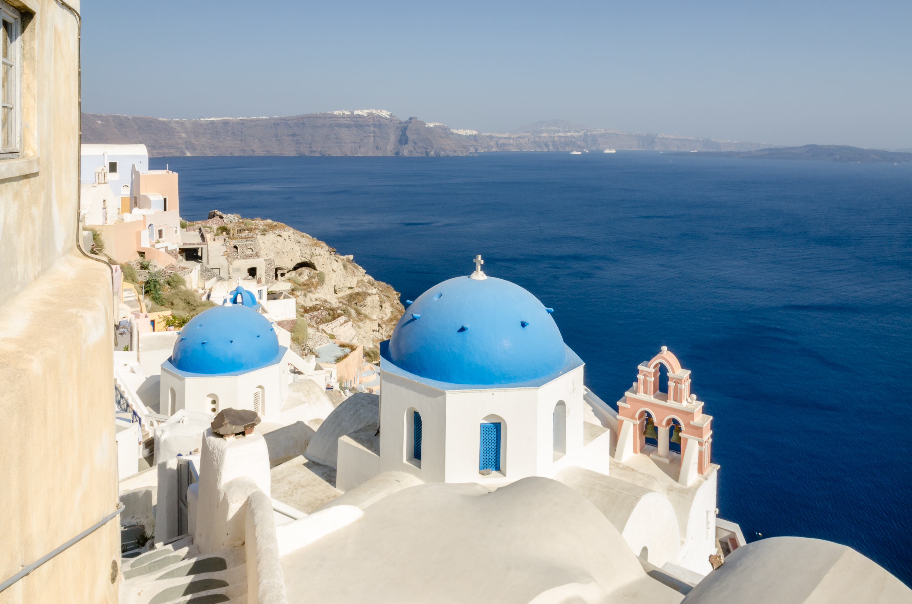
OIA (pop 1000). A NM “small town” on the northern tip of the island, it is reached by a cliff edge walkway and road through a series of link settlements. After the devastating earthquake of 1956, restoration and upmarket tourism transformed it into one of the loveliest villages in the Cyclades. Built on the steep slope of the caldera, many of its houses are in niches hewn into the volcanic rock. From the bus station, head uphill to the central square and the main street that skirts the caldera. The tiny port of Ammoudi is 300 steps below Oia at the base of red cliffs.
Oia is best known for its sunsets.
On my last day in Santorini, I got up early and drove to Ancient Akrotiri which opened at 8 am.
Ancient Akrotiri. This Minoan outpost was buried during the eruption of 1613 BC. Excavations uncovered an ancient city buried under the ash: buildings, some 3-stories high, frescoes, and ceramics.
This is an archaeological dig housed under a gigantic roof. There is little to see as it is all ruins only partially restored. The only interesting thing was the dressed stone visible in a few buildings on the corners and windows. 12€
I then drove to Ancient Thira. Drive around the mountain by the airport and climb an amazing road with 22 hairpin switchbacks to a saddle between the two peaks. There is nothing here of old Thira (and I can’t believe they lived here). Trails go to the top of each mountain.
I then drove to the airport and dropped off my rental car in the public lot. There was a fellow from the company waiting for me.
OIA (pop 1000). A NM “small town” on the northern tip of the island, it is reached by a cliff-edge walkway and road through a series of link settlements. After the devastating earthquake of 1956, restoration and upmarket tourism transformed it into one of the loveliest villages in the Cyclades. Built on the steep slope of the caldera, many of its houses are in niches hewn into the volcanic rock. From the bus station, head uphill to the central square and the main street that skirts the caldera. The tiny port of Ammoudi is 300 steps below Oia at the base of red cliffs.
Oia is best known for its sunsets. There were thousands lined up on the terraces, cafes, and a large platform.
On the way back, I walked along the narrow tourist lane and found a viewpoint that looked down to the famous “Santorini view” of cascading white cubist buildings and blue domes. None are accessible as they are private.

Santorini Windmills. There are a few collections of windmills on the island. The two most prominent are the two in this photo in Oia. These have thatched roofs and 12 poles that form the vanes. There are three at a condominium complex on the south.
BEACHES.The island slopes gently down to sea level on its eastern and southern sides and you’ll find dark-coloured beaches of volcanic sand that get very hot. Perissa is the busiest. Perivolos and Agios Georgios are further south. Red Beach, near Ancient Akrotiri, has high red cliffs and smooth, hand-sized pebbles submerged under clear water.
Vlyhada is also on the south coast.
Nea Kameni. This unpopulated islet in the centre of Santorini’s caldera is still volcanically active and surrounded by deep green, sulphurous water. From the quaint port, you can walk up to the volcano’s crater. Reach by boat tour.
Aspronisi. This tiny speck of an island is a fabulous place for swimming in the warm water.
Palia Kameni. This islet has natural hot springs. Water reaching temperatures of around 33°C bubbles to the surface and then pours into the sea. Relax among the copper-colored rocks, soak in the warm volcanic waters or join the regulars in slathering yourself with sulphurous mud.
Thirasia. Once part of the main island, Thirasia separated from Santorini following the earthquake in 236 BC. Its relaxed, cliff-top old town is unspoiled and offers wonderful views back to Santorini. Reach by boat tour.
Other Towns. Inland lie charming villages such as Vourvoulos, to the north of Thira, and Pyrgos and Megalohori to its south.
NAXOS (pop 13,000)
Naxos is the largest of the Cyclades and has mountains to prove it. It offers the best of both worlds, a classic island experience balanced by being pleasantly landlocked in the deep heart of the mountains. There are numerous sandy beaches and the island is a great place to explore on foot along the many surviving paths between villages, churches, and other sights.
It was on Naxos that an ungrateful Theseus is said to have abandoned Ariadne after she helped him escape the Cretan labyrinth. But there are certainly worse places to be left behind. Naxos was a cultural centre of classical Greece and of Byzantium, while Venetian and Frankish influences have also left their mark.
Naxos is the Cyclades’ land of plenty – lush and fertile – citrus fruit, corn, potatoes, fresh olives, figs, grapes and wine are produced here in abundance.
HORA (pop 6800)
On the west coast of Naxos, is the island’s port and capital. It’s a large town, spread well beyond the harbour area and divided into two historic neighbourhoods of the Venetian era:
Bourgos, where the Greeks lived. To see the Bourgos area, head into the winding backstreets behind the northern end of Paralia.
Kastro. The most alluring part of Hora is the hill-top residential Kastro, where the Roman Catholics lived. Marco Sanudo made the town the capital of his duchy in 1207, and several Venetian mansions survive.
BEACHES
Agios Georgios. Conveniently located just south of the town’s waterfront, Naxos’ town beach. It’s backed by hotels and tavernas at the town end and can get very crowded, but it runs for some way to the south and its shallow waters mean the beach is safe for youngsters.
Agios Prokopios .The next beach south of Agios Georgios, it lies in a sheltered bay to the south of the headland of Cape Mougkri. It merges with
Agia Anna, a stretch of shining white sand, quite narrow but long enough to feel uncrowded towards its southern end. Development is fairly solid at Prokopios and the northern end of Agia Anna.
Sandy beaches continue down as far as Pyrgaki and include Plaka , Kastraki and Alyko.
Mikri Vigla. One of the best of the southern beaches, where golden granite slabs and boulders divide the beach into two.
Mt Zeus (1004m) is the Cyclades’ highest peak and dominates the island’s interior. To climb Zeus, from the road-end parking, follow a walled path past the Aria Spring, a fountain and picnic area, and on to a very rough track uphill to reach the Cave of Zeus, a large, natural cavern at the foot of a cliff. The path leads on from here steeply to the summit of Zas, a stiff hike of several kilometres.
Tragaea. The Tragaea region is a vast plain of olive groves and unspoilt villages, couched beneath Mt Zeus.
Filoti , on the slopes of Mt Zeus, is the region’s largest village. From Filoti, you can reach the on the slopes of Mt Zeus. There’s a junction signposted Aria Spring and Zas Cave, about 800m south of Filoti.
Halki. This historic village lies at the heart of the Tragaea, about 20 minutes’ drive from Hora. The best example of historic Naxos, it is full of the handsome facades of old villas and tower houses, legacy of a rich past as the one-time centre of Naxian commerce.
Paths and lanes radiate from Halki through peaceful olive groves and flower-filled meadows. The atmospheric 11th-century Church of St Giorgios Diasorites lies a short distance to the north of the village. It contains some splendid frescoes.
Since the late 19th century, Halki has had strong connections with the production of kitron, a unique liqueur. The citron (Citrus medica) was introduced to the Mediterranean area in about 300 BC and thrived on Naxos for centuries. The fruit is barely edible in its raw state, but its rind is very flavourful when preserved in syrup as a ghlika kutalyu (spoon sweet). Kitroraki, a raki, can be distilled from grape skins and citron leaves, and by the late 19th century the preserved fruit and a sweet version of kitroraki, known as kitron, were being exported in large amounts from Naxos.
ANDROS
Satisfyingly remote in places, Andros is a mix of bare mountains, green valleys and out-of-the-way beaches. Neoclassical mansions and Venetian tower houses contrast with the rough unpainted stonework of farm buildings and patterned dovecotes. A network of footpaths is also maintained, and the island has a fascinating archaeological and cultural heritage.
AMORGOS
This lovely island rises from the sea in a long dragon’s back of craggy mountains. There’s plenty of scope for beaching, but Amorgos is much more about archaeology and the outdoor world – there’s great walking, scuba diving, and a burgeoning rock-climbing scene for experienced climbers.
SIFNOS
As you approach by sea, Sifnos seems a barren place of heavy hills until the port of Kamares appears. Beyond the port and between the flanking slopes of rugged mountains lies an abundant landscape of terraced olive groves, almond trees, juniper and aromatic herbs. Plenty of unspoiled paths link the island villages, and the island has a tradition of pottery making, basket weaving, and cooking.