
Murcia Aug 17-18, 2021
Ohihuela. In the NM small town series, there was little inspiration.
MURCIA (City)
Cathedral of Murcia. This church has an unusual shape with the altar and opposite it the intricately carved wood choir and organ, are surrounded by an oval corridor (the other two naves). The gilt altar is a mass of statues behind the solid silver altar. The Capella de ls Valez is a wonder of carved stone. The bell tower is very tall.
Passarela de Jorge Marequi. This modern footbridge crossing the River Segura has a large central arch from which are suspended cables to each side supporting the curving and slightly arched deck.
Faro Cabo de Palos. La Manga. Built-in 1865, this is a great round stone lighthouse sitting on a large stone base and a nice two-story building. 
Getting here was a chore with the masses of tourists visiting the beaches and the lighthouse. It is a great place to watch sunset and sunrise. I slept here.
Teatro Romano de Cartagena. This restored theatre still functions with a modern stage in front of the remains of the original with 8 partial columns.
Pulpi Geode is a giant geode found in Spain near the town of Pulpí in 1999. This geode is one of the larger documented geodes in the world to date. Geodes are formations that arise in rocky cavities whose walls, over the centuries, have been covered with crystallized minerals projected inwards. It occupies a space of 10.7 m3 (8 m long by 1.8 m wide by a 1.7 m average high) and is located at a depth of 50 m in the Pilar de Jaravía lead mine, in the Sierra del Aguilón, in the municipality of Pulpí, coinciding with the sea level, 3 km from the coast. It has a funnel shape, with the narrowest part being L-shaped. It is notable on a worldwide scale for both its size and the transparency and perfection of the selenite (gypsum) crystals lining the interior, which reach up to 2 m in length, with 0.5 m being the average. To understand the origin, there are two phases. In the first place, the hole was formed in the rock due to the karstification of the rocks that make up the Sierra del Aguilón, accompanied by leaks of very hot water of volcanic origin. And secondly, there was the mineral deposit that would later become the crystals. These crystals are nothing more than calcium sulphate, that is, gypsum. A very common material that, subjected to conditions as specific as those described above, could acquire such a sensational appearance over time.
The Mina Rica (Rich Mine) is home to many other smaller geodes such as the Split Geode or the Swallowtail Geode. The visit has a guided tour through the main galleries of the Mina Rica (Rich Mine), where a specialized guide will show visitors the most interesting details about the geology, minerals and history of the Pulpí Geode. Tickets must be purchased in advance to avoid running out of space on the day you choose to carry out this fascinating visit. 22€
Other large geodes include the Crystal Cave (Ohio), discovered in 1887 at the Heineman Winery on Put-In-Bay, Ohio.
Mojacar is an elevated mountain village displaying the traditional white colour from its earlier days. Mojácar has been inhabited by many different groups since antiquity. Populated since the Bronze Age around 2000 BC, traders such as the Phoenicians and Carthaginians arrived to serve the growing communities. Under Greek dominion, the settlement was called Murgis-Akra, whence came the Latinized Moxacar, the arab Muxacra and finally the current name of Mojácar.
Murgis-Akra and its lands became incorporated into the Nasrid sultanate, and the town found itself on the frontier with the Christian forces to the east. Watchtowers and fortresses were built, or reinforced, during the 14th century. On June 10, 1488, the town was annexed to the Kingdom of Castile. Mojácar, once again, began to expand until the early 18th century, when the census of the time recorded 10,000 people. Around the middle of the 19th century, Mojácar began another period of decline.
Several severe droughts brought about this drop in the town’s fortunes, with a consequent emigration to other parts of Spain, Europe or Hispanic America. The depopulation of the town was halted in the 1960s when tourism began to reverse the trend.
Mojácar has the highest GDP per capita in the whole of Andalusia at €90,000 per year
Indalo. The Indalo, or Mojácar man, is a magical totem said to bring protection and good luck. From times past was painted onto the fronts of houses once the whitewash was dry with the belief that it kept away the evil eye and protected those within from storms. The figure might be interpreted as a man holding a rainbow between his outstretched arms. The original totem is thought to be around 4,500 years old, and the earliest known one appears among other prehistoric paintings in a cave in Vélez-Blanco. The name, Indalo was coined by a group of artists and intellectuals who settled in Mojácar in the early 1960s, attracted by the atmosphere of the town, and who commercialised the totem which today signifies the whole province of Almería.
A NM small town, this is a white town on the top of a mountain with a million tourists and no parking.

I elected to drive the coastal route – what a mistake – endless beach towns and impossible traffic jams. The town just north was especially onerous. I took a sinuous impossible road for 30 minutes to avoid one endless line. Playa de los Muertos just after had thousands of cars parked for miles everywhere. It didn’t end till I got to the tiny road that had a barricade halfway across (to prevent all the beachers from accessing. The road climbs up switchbacks to the top of the cliffs.
Faro de la Mesa Roldan. The Roldán Table is a volcanic plateau crowned by a coral reef, full of fossils, with a height above sea level of about 220 meters, which makes it a magnificent view of the coastal area of the natural park of Cabo de Gata- Nijar and the surrounding mountains. The Mesa Roldán Lighthouse was inaugurated in 1863, being electrified in 1972. Currently, it is fully modernized and automated, with the characteristic of 4 flashes every 20 seconds and a range of 23 miles. It was for many years the tallest lighthouse in all of Spain, until the construction of the Torre de los Lobos lighthouse in Rodalquilar. Currently, it houses a small museum of lighthouses, with the collection of its lighthouse. There is a hiking route, which allows you to enjoy its magnificent surroundings.
What an uninspiring lighthouse but in a dramatic location. There is a castle ruin near the lighthouse
Faro de Punta de la Polacra. It is located in the Cabo de Gata-Níjar natural park and opened in 1991, so it has become the last lighthouse built in Almería. The lantern is placed on an 18th century watchtower , the “Torre de los Lobos”. Its focal height, 281 meters above sea level, makes it the tallest lighthouse in Spain and the Mediterranean.
This was a much easier drive with basically no traffic and the lighthouse much more interesting – a great round stone base. Views were panoramic.
Playa de Monsul. An elevated boardwalk crosses the dunes. The beach has several breakwaters.
I needed gas so stopped and did one of the dumbest things of my life. I grabbed the nearest hose and put about 4 litres of gas in before realizing it. Hoping to dilute it (even though gas is lighter doesn’t mix with diesel, an oil, I filled the tank with 55 litres of high test diesel. Almeria was close, I stopped at a McDonalds and Googled the problem. All warned that gas would destroy the fuel injectors, cause irreparable harm to the engine and void my warranty. But small amounts should not be a problem. There was a garage next door to Mickeys and they said they would try to fit me in the next 24 hours. I had many business issues that I had been procrastinating on and this was a welcome break to start to deal with them. I waited until 7 pm when the front-end lady and the head mechanic came over to the van and thought that it was no problem. Simply drive on and by filling the tank when it approached half nothing should happen. This would also save me the 86 euros of fuel but 150 euros for the repair. I didn’t think that was worth the engine but they confidently reassured me. So I left Almeria for the long drive to Ubeda and Baeza. It was over 200kms each way and easily my biggest drive to see one place and to get one more WHS. They can be a lot of work.
I felt sleepy almost immediately and pulled over at the nearest exit (Spain does not have rest areas and this was a non-toll road, so there were also no large service centers). There was nothing here so I went down an old road, parked and had one of my best night’s sleep. It was so dry, there were no flies and slept with the big door wide open for a great breeze and finally some cool.
Renaissance Monumental Ensembles of Úbeda and Baeza. WHS
The urban layout of the two small cities of Úbeda and Baeza dates back to the Moorish 9th century and to the Reconquista in the 13th century. In the 16th century, the cities were renovated along the lines of the emerging Renaissance. This eventually influenced the architecture of Latin America. Úbeda and Baeza are 9 km away from each other.
The sixteenth century was the golden era of Baeza and Úbeda. It grew rich from several industries, notably textiles. The noble families were well connected with the Spanish Imperial state. They hired major architects of the era to design the present cathedral, churches, public buildings, and private palaces in the then-fashionable Italian style.
Úbeda (pop 34,733). developed outstanding noble architecture: the Plaza Vázquez de Molina is surrounded by civil and religious buildings built from 1530 to 1580. The funeral chapel of El Salvador and the Vázquez de Molina Palace (today’s Town Hall) form the greatest Renaissance architecture ensemble in Spain.
Úbeda, on the border between Granada and Castile-La Mancha, was an important geographic buffer. During the XVI century, these important Castillian aristocratic families reached top positions in the Spanish Monarchy administration. Due to the patronage of arts of these competing families, Ubeda became a Renaissance focus in Spain and from there Renaissance architecture spread to the Kingdom of Seville and America. This thriving period ended because of the 17th crisis. The last years of the 18th century, the town started to recover its economy, with the help of agriculture and handmade industries.
The city possesses 48 monuments, and more than a hundred buildings of interest, almost all of them of Renaissance style.
The most outstanding place is Vázquez de Molina Square, surrounded by several Renaissance buildings
Vazquez de Molina Palace, today the Council Town
Basílica de Santa María de los Reales Alcázares.
Palacio de las Cadenas (named for the decorative chains which once hung from the façade) and
Chapel of the Savior or Capilla del Salvador was constructed to house the tombs of the local nobility. Both the interior and exterior are decorated. An elaborate metalwork screen
Hospital de Santiago has square bell towers and a graceful Renaissance courtyard, which is now the home of the town’s Conference Hall.
Parador hotel is housed in a 16th-century palace, the residence of a high-ranking churchman,
Baeza developed as an ecclesiastic and educational centre: the Cathedral and Santa María Square, the old Seminary and the University that became the site of the International University of Andalusia in the 1970s.
The coexistence of Christian, Islamic and Jewish cultures favoured freedom and originality of artistic expression. Islam had a medieval tradition in stonework building Italian constructions with Islamic influences.
The city declined in importance in the seventeenth century, with the only remaining industry consisting of local production of grain and olive oil. As few newer structures were built during this period, this had the effect of preserving the town’s Renaissance legacy. The university closed for a time before being reopened by the nineteenth century[4] as a seminary. In the 1870s, the population was around 11,000;[4] over the next few decades, the Linares–Almeria railway was constructed nearby and town’s population grew to 14,000 by 1900.
Baeza houses several fine public buildings:
Natividad de Nuestra Señora Cathedral, presents an early Gothic and Plateresque pilasters and crossed vaults finished in the XVI century in a Renaissance style
Town Hall was originally built as a combined courthouse and prison, leading to two separate main entrances
Baeza University, established in 1533 or 1538, now a secondary school
Santa Cruz Church, a Romanesque church with a two-aisle nave and semicircular apse. A side wall incorporates a Visigothic arch.
St Paul’s Church, a Gothic church with a Renaissance portal with a two-aisle nave and Gothic chapels. Includes the tomb of Pablo de Olavide.
Chapel of St Francis, in the ruins of a Renaissance building from 1538 formerly used as a monastery
Jabalquinto Palace has an Gothic entrance flanked by two cylindrical pilasters with Plateresque capitals with mocárabes ornamentation, a Renaissance courtyard, and a Baroque staircase
Spain Plaza (Plaza de España)
Constitution Plaza (Plaza or Paseo de la Constitucíon), including a marble fountain decorated with Caryatides.
St Mary Fountain (1564)
The Fountain of the Lions, from the Ibero-Roman ruins of Cástulo
Úbeda Gate and Jaén Gate.
Villalar Arch (Arco de Villalar), erected for Charles V’s 1526 visit to honor his 1521 victory at Villalar.
It was late by the time I left Baeza and I then needed a nap to continue driving. With Nerja cave closing a 7pm, it was a mad drive at high speed to get there.
Rock Art of the Mediterranean Basin on the Iberian Peninsula WHS
Málaga and Cádiz. Has 180 caves, most in Cádiz province. However, the famous Nerja caves are located at the east of Málaga province.
Cueva de la Pileta – a 22,00 year old cave
Cueva de Doña Trinidad, Ardales. Has 1/2 a kilometer of tunnels and underground compartments.
Cueva del Gato” (in Sierra de Ronda) – a cave 4,5 km long with underground lakes and rivers with the possibility to bath or kayak under a waterfall.
Cueva de Tesoro, Rincón de la Victoria – a coastal cave with 500 m of rock art paintings.
Cueva de la Tinaja” and “Cuevas de Los Organos”, both in Sierra de las Nieves, large dramatic impressive rock formations.
Andalucía has more than 200 cuevas with 69 prehistoric sites most located between Jaén, Almería and Granada. 42 caves in Jaén include “Cueva de la Graja” (with neolithic people paintings) and and “La Cueva del Gabar”. 25 are in the Natural Park of Sierra María-LosVelez in Almería: “Cueva de los letreros” and Caves of Sorbas, caves with no man-made passages.The most talked about caves in Andalucía are located in Nerja, La Pileta and Ardales (in Málaga province).
Nerja Cave. When first discovered, this cave had skeletons, ceramic pottery and rock art that dated back to 43,500 to 42,300 years, perhaps the oldest art known to humanity. Prior to this discovery, the oldest works of art were said to be 32,00 years old and found in Chauvet Cave in southern France. The cave has wonderful speliotherm formations including Spain’s largest stalagmite at 105ft (32m) tall.
When I arrived at 5 pm, there were no tickets until 3:30 pm the next day. Except as a single, there was one ticket so I entered with the 5:45 group. Despite holding so much prehistoric art, I never saw any during the tour. It is certainly not highlighted in any way.
15E including audioguide.
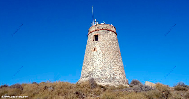
Mediterranean Wind Mills (26/06/1998). Muslims brought them to Europe in the Middle Ages. Sail mills spread throughout the Mediterranean basin during the 12th and 13th centuries. In Lower Andalusia, most have 8 sails, in Cartagena: 8 sails and adaptations for raising water. In Portugal: 4 sails.
During the 19th and 20th centuries during the industrial revolution, the expansion of windmills ended almost everywhere in Europe. However In the Cartagena Field, some were still used until very recently for pumping water and storage of molding flour.
When I drove through Cartagena Province, one passes many windmills. Most are white plaster. One was converted into a house and one was totally caved in.
The Wine in Iberia. Tentative WHS. This a group of cultural assets that demonstrate the exchange of ideas between two different communities whose result is the emergence of the Iberian Culture, with Wine as one of its driving threads. The Phoenician maritime commercial networks in which the wine participates, the existence of very old settlements where the Phoenician and indigenous population coexist in which wine is already produced on a commercial scale and, finally, the acquisition, development and innovation by the Iberian populations of the techniques of wine production.
The wrecks I and II of Mazarrón (Murcia) and wreck 1 of Bajo de la Campana in San Javier (Murcia), which prove the existence of commercial networks of how the wine consumption was introduced in the Iberian Peninsula
The site of Castillo de Doña Blanca (Puerto de Santa María, Cádiz), a fundamental example of the coexistence of indigenous populations of Iberia and others from Phoenician where the transfer of customs and techniques related to wine.
The Stone wine presses around the Cabriel River (Requena, Valencia).
MALAGA
Puenta de la Trinidad. An older grey steel girder bridge across the
Mercato Central de Atarazanas. A huge market with great steel girders and decorated iron works. The center (fish) has a stained glass window covering the entire end. Right is produce and left is meat and bread. There are few eateries.
Muelle Uno shopping centre. Centre Pompidou Malaga, a branch of the storied Paris contemporary art museum with a square plexiglass cube.
La Farola de Malaga. On a 2-storey square base it is a white plastered LH sitting on the harbour.
Cabopino Beach. Elevated boardwalks cross the dune area down to the big yellow sand beaches separated by several breakwaters. Umbrellas, lawn chairs, coolers and sacks of food are necessary for a day at the beach.
I then drove to La Linea de la Concepcions, just outside Gibraltar. I had a hankering for fish and chips. I got great wifi outside a McDonalds and got caught up on the million things I don’t like to access on my phone. Checking the NM lists showed that I had missed two WHS back the way I had been the day before. So I entered them, some places on the way and everything to see in Seville and hit the road.
G Maps wanted me to go on the freeway that I had been on yesterday to save 20 minutes but I chose the slow way and that turned out to be a great choice despite being sinuous, slow and bumpy pavement. I eventually climbed up to the Carraterra de Montana that snakes across the top of a ridge for miles. Like Rhonda and all the famous “white towns” nearby, these small villages perched on the sides of mountains are also all white. Some of the lovely towns were Gaucin, Algatocin, Atajete and Alpandeire. Frequent miradors have lovely hand painted tiled maps and panoramas of the views listing all the landmarks. At one, I could see 7 white towns scattered across the mountains. Views were down steep drop offs.
My destination was Juzcar, a blue town. The road there was basically one-lane and the lanes through the town impossibly narrow. The cafes along the highway were crowded and there was no parking anywhere. I drove a few kms above and parked at a dirt pull off for the night. Because of the heat, I have been sleeping with my big door wide open. Because of the dryness, there are no bugs and the breeze is refreshing. Having to cover with a blanket is necessary and so nice.
I got up very early at to drive and still be able to get to Caminito del Rey, well before opening at 9 to be able to get a reservation.
Ruins of Acinipo. About 20kms from Ronda, this was founded by retired Roman veterans of Caesar’s legions in 45BC. The remaining ruins include a 2,000 seat Roman theatre, one of the best-preserved in Roman Hispania, and still in use today. The modern steel stage is backed by a largely intact wall. There are also remnants of a stately home and baths. The 32-hectare city had a population of about 5,000. Acinipo fell in 429AD. It is sometimes referred to as “Ronda la Vieja” despite the fact that Acinipo (the original settlement of Ronda) coexisted for centuries. At 1000m altitude, views exist in all directions. Walk past multiple piles of stones up the hill to the theatre. Free
Caminito del Rey. (The King’s Little Path) is a walkway, pinned along the steep walls of a narrow gorge in El Chorro, near Ardales. The name derives from the original name of Camino del Rey (King’s Pathway), abbreviated locally to el caminito. The walkway had fallen into disrepair and was partially closed for over a decade. After four years of extensive repairs and renovations, the walkway re-opened in 2015. It has been known in the past as the “world’s most dangerous walkway” following five deaths in 1999 and 2000.
The walkway was built to provide workers at the hydroelectric power plants at Chorro Falls and Gaitanejo Falls with a means to cross between them, to provide for transport of materials, and to help facilitate inspection and maintenance of the channel. The construction began in 1901 and was finished in 1905. King Alfonso XIII crossed the walkway in 1921 for the inauguration of the dam Conde del Guadalhorce, and it became known by its present name. The walkway is 1 metre (3 ft) in width and rises over 100 metres (330 ft) above the river below.
The original path was constructed of concrete and rested on steel rails supported by stanchions built at approximately 45 degrees into the rock face. It deteriorated over the years, and there were numerous sections where part or all of the concrete top had collapsed. The result was large open-air gaps bridged only by narrow steel beams or other supports. Few of the original handrails existed, although a safety wire ran the length of the path. Several people lost their lives on the walkway and, after two fatal accidents in 1999 and 2000, the local government closed both entrances. Even so, in the four years leading up to 2013, four people died attempting to climb the gorge.
The regional government of Andalusia and the local government of Málaga agreed in June 2011 to share costs of restoration (including car parking and a museum) of €9 million. The project took approximately three years to complete. Many of the original features remained in place. The new pathway still offers a walk of 2.9 km along the side of the gorge.
This route has changed considerably since I was last here in 2011. Then it was impossible to do. The route followed a narrow metal track suspended on a vertical cliff. Then dubbed “the most dangerous hike in the world” (and from the YouTube videos, it was) as most of the cross pieces were missing. Only daredevils did it comfortably. In 2011, it was impossible as the first 20 meters of track had been completely removed.
Now it is easily the most popular hike in Spain with literally thousands doing it daily. Reservations are required (in mid-August, all were booked until mid-September). 50 tickets are available daily on a first-come-first-serve basis beginning at 9 am at the ticket booth at the very start of the route. People start lining up at 5 am for these. A more viable option would be to join a guided tour that may have blocks of tickets. It appears that most do the trip this way as I passed several groups of 20-30.
To get to the beginning, look for the easily missed entrance on the road, a low tunnel hewn out of the rock. From here everyone must walk 1.5kms initially through the tunnel, then a trail and a second short tunnel. Views are nice down to the lake. The start and the ticket booth are obvious because of all the people around. Hard hats are issued. The reviews all suggest that this is not for people with vertigo, I don’t think they understand the meaning of the word vertigo (an inner ear disorder with spinning dizziness most commonly induced by head position) and really mean fear of heights.
I could not have done it anyway as flip-flops are definitely not allowed.
Park along the road, at a lot a minute past the entrance for 2E, or better yet follow Google Maps well past the tunnel entrance and park at the barricade that is actually just above the exit of the first tunnel. No one was here. This road also offers the best views of the lakes.
The actual guided hike takes about 90 minutes and follows a completely reconstructed route, part over a bridge suspended above a narrow gorge. Even without tickets it is a pleasant walk to the beginning.
Dolmen de Antequera. WHS. Dolmens are the first megalithic constructions in Europe formed by several slabs nailed vertically into the ground and one or more resting on them horizontally as a roof.
Antequera dates from the Neolithic period 5-6,000 years ago. Instead of being orientated to the sun, these were oriented towards nearby mountains.
Dolmen Menga. A gallery shaped tomb 27.5m long, 6m wide and 3.5m high built with 32 megaliths, the largest one at the back weighing about 180 tons and sitting over a deep, perfectly round well. Ten giant slabs, five on each side are at the entrance. It probably served as a grave for the ruling families as skeletons of several hundred people were inside when first discovered in the 19th century.

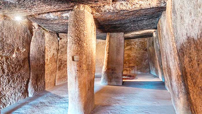
Dolmen of Viera. Next to Menga, this is a narrow passage with 25 giant stones. Because of its narrowness, there are no vertical slabs. The corridor ends at a large block with a square hole in the middle and a small number of small rocks on the floor.
This was frustrating to see as only 2 were allowed in at once and the line was impossibly long.
 |
Thosos de El Romaeral. About 4kms away.
Park Arqueologico Torreparedones. Tentative WHS. The site was inhabited from the end of the Neolithic era until the beginning of the 16th century, reaching its maximum splendour in Iberian and Roman times, when it obtained the status of colony or municipal district.
The most significant elements are Roman buildings like the East door with a road in perfect condition, the forum, and adjacent buildings, spas and the market, the medieval castle, a 16th-century chapel, the necropolis with underground tombs, and the Iberian-Roman sanctuary located to the South, outside the walls, where hundreds of votive offerings have been sculpted in stone, and where the faithful deposited their offerings for several centuries dedicated to the god which was worshipped there: Dea Caelestis.
The chance discovery of the so-called “Mausoleum of the Pompeyos”, in 1833, a monumental tomb containing the incinerated remains of 12 people from the same family, with their names etched in stone urns, was a landmark in the history of the site because it drew the attention of numerous national and foreign researchers.
Caliphate City of Medina Azahara (Conjunto Arquaeologica Madinat al-Zahra). WHS. “The radiant city” was a fortified place city on the western outskirts of Cordoba and its remains are a major archaeological site today. The city was built in the 10th century by Ubd-ar-Rahman III (912-961), a member of the Umayyad dynasty and the first caliph of Al-Andalus in 929 and this new title required the establishment of a new city. Construction began in 936 and continued in multiple phases throughout his reign and that of his son Al-Hakam II (r. 961-976). The new city included ceremonial reception halls, a mosque, offices, residences, gardens, a mint, workshops, barracks service quarters and baths. It served as the capital of the Caliphate of Cordoba and its center of government.
After al-Hakam II’s death, it ceased being the center of government. Between 1010 and 1013, it was sacked during a civil war and abandoned. Many of its materials were reused elsewhere.
About 10 of the 112 hectares have been excavated including the main palaces. The museum is built low with much of the space underground. With the remains of basilicas, mosques and porticos of an early Medieval palace. It is mostly reconstruction with little original and not so interesting.
Note that it closes at 3 pm.
Outside of Seville.
Mercadillo El Jueves. The Thursday market is the oldest open-air market in Seville , which is organized this day of the week in the populous Calle Feria. Its origin is unknown, although it is assumed that it predates the conquest of the city by King Ferdinand III of Castile. It has been held every Thursday morning on Feria Street . Today it is a market for antiques and second-hand objects , although originally all kinds of articles were offered.
The Hadriatic City of Italica. Tentative WHS. Italica north of modern-day Santiponce, 9 km northwest of Seville. It was the birthplace of Roman Emperors Trajan, Hadrian, and Theodosius (possibly). It flourished under the reign of Hadrian, becoming an elaborate urban centre and obtaining the high status of colonia. The modern town of Santiponce overlies the pre-Roman Iberian settlement and part of the well-preserved Roman city.
Italica was the first Roman settlement in Spain and the first Roman city outside of Italy. It was founded in 206 BC by Publius Cornelius Scipio during the Second Carthaginian War upon a native Iberian town of the Turdetani (dating back at least to the 4th c. BC) as a settlement for his Italic veterans, likely a majority of socii and a minority of Roman citizens, and named Italica after its inhabitants. The nearby native and Roman city of Hispalis (Seville) was and would remain a larger city, but Italica’s importance derived from its illustrious origin.
As time progressed, Italica attracted new settlers from Italy and also grew with the sons of Roman soldiers and native women. A branch of the Gens Ulpia from the Umbrian city of Tuder (the Ulpi Traiani) and a branch of the gens Aelia from the Picenian city of Atri (the Aelii Hadriani) were either among the original settlers of Italica or among the groups that later moved in the town (at any time between the third century BC and first century AD), as these tribes were the respective families of the Roman emperors Trajan and Hadrian who were born there.
The vetus urbs (original or “old” city) developed into a prosperous city and was built on a Hippodamian street plan with public buildings and a forum at the centre, linked to a busy river port. Italica thrived especially under the patronage of Hadrian, like many other cities in the empire under his influence at this time, but it was especially favoured as his birthplace. He expanded the city northwards as the nova urbs (new city) and, upon its request, elevated it to the status of colonia as Colonia Aelia Augusta Italica. He also added temples, including the enormous and unique Traianeum in the centre of the city to venerate his predecessor and adopted father, and rebuilt public buildings.
The city started to dwindle as early as the 3rd century when a shift of the Guadalquivir River bed, probably due to siltation, a widespread problem in antiquity that followed removal of the forest cover, left Italica’s river port high and dry while Hispalis continued to grow nearby.
As no modern city covered many of Italica’s buildings of the nova urbs, the result is an unusually well-preserved Roman city with cobbled Roman streets and mosaic floors still in situ. Many rich finds can also be seen in the Seville Archaeological Museum, with its famous marble statue of Trajan.
The archaeological site of Italica encompasses mainly the nova urbs with its many fine buildings from the Hadrianic period. The original vetus urbs (old town) lies under the present town of Santiponce. The small baths and the Theatre are some of the oldest visible remains, both built before Hadrian.
Italica’s amphitheatre was the third largest in the Roman Empire at the time, being slightly larger than the Tours Amphitheatre in France. It seated 25,000 spectators, about half as many as the Colosseum in Rome. The size is surprising given that the city’s population at the time is estimated to have been only 8,000, and shows that the local elite demonstrated status that extended far beyond Italica itself through the games and theatrical performances they funded as magistrates and public officials.
From the same period is the elite quarter with several beautiful (and expensive) houses decorated with splendid mosaics visible today, particularly the House of the Exedra, House of the Neptune Mosaic, House of the Birds Mosaic, House of the Planetarium Mosaic, House of Hylas, House of the Rhodian Patio.
The Traianeum was a large, imposing temple in honour of Emperor Trajan, built by his adopted son and successor, Hadrian. It occupies a central double insula at the highest point of nova urbs. It measures 108 x 80 m and is surrounded by a large porticoed square with alternating rectangular and semicircular exedra around its exterior housing sculptures. The temple precinct was decorated with over a hundred columns of expensive Cipollino marble from Euboea, and various fountains.
The aqueduct of 37 km total length was first built in the 1st c. AD and extended under Hadrian to add a more distant source for supplying the expanded city. It fed a huge cistern at the edge of the city which remains intact. Some of the piers of the arches are still visible near the city. 1.5€ for non-Euopean residents.
Birth of the New Man (Huevo de Colón). The Columbus egg is a concept defined by as a “thing that appears to have a lot of difficulties but turns out to be easy when knowing its artifice.” Girolamo Benzoni in his History of the New World ( Venice, 1565 ) tells the following story:
While Christopher Columbus was at the table with many Spanish nobles, one of them said: ‘Mr. Columbus, even if your grace had not found the Indies, we would not have missed a person who would have undertaken an adventure similar to his, here, in Spain, which is a land rich in great men who are very knowledgeable in cosmography and literature. ‘ Columbus did not respond to these words but, having requested that an egg be brought to him, he placed it on the table and said: ‘Gentlemen, I bet with any of you that you will not be able to put this egg upright as I will, naked and without any help. ‘ They all tried without success. When the egg returned to Colón, he subtly struck it against the table, crushing the curvature of its base, allowing it to stand. Everyone present was confused and understood what he wanted to tell them:
From this story comes the popular saying that “Columbus was the first man who … laid an egg standing up” and that the expression “like Columbus’s egg” is used to describe something that seemed complex or difficult and that is simple or simple once understood.
This monument is truly huge – the wall of the egg is .5m thick with banner cutouts and huge metal ropes. Columbus holds a banner with his three ships. The egg sits in a large round pool/fountain at the far end of a large urban park Parc Aramillo, a rather obscure place.
SEVILLE
Torre Sevilla. Known until 2015 as the Pelli Tower, is an office skyscraper in Seville built between 2008 and 2015. The tower is 180.5 metres (592 ft) tall and has 40 floors. the tallest building in Andalusia and in the city of Seville, and the seventh-tallest in Spain. It provides a panoramic view of all Seville. It is an office building,
The tower is flanked by two four-story podium buildings also designed by César Pelli. The curved edges of the podium buildings define a plaza that opens on the north and south and narrows at the center, creating a pedestrian-scaled commercial street.
The tower notably hosts a 5-star hotel, Eurostars Torre Sevilla, along with various offices.
Santa Maria Magdalena.
Metropol Parasol (Sertas de Sevilla) is a structure in the form of a wooden and concrete pergola located in the central Plaza de la Encarnación. It has dimensions of 150 meters long, 70 meters wide and an approximate height of 26 meters. Its base houses a traditional market and restaurants on the ground floor, a performance plaza and the Antiquarium archaeological museum. The structure is crowned with a terrace and a viewpoint that offers a panoramic view of the old part of the city.
The work, composed mainly of laminated wood, is made up of a large parasol-shaped grid supported on six pillars that span both the Plaza de la Encarnación and the Plaza Mayor of the city. Each of its ribs make up a spatial distribution where each rib offers its own curvature, which gives the whole a sensation of wave movement. The solution was to modify the structure of the parasols by replacing the metal with laminated birch wood from Finland, which meant an increase of 25.8 million euros in their cost.
Hotel Inglaterra. This has an unimposing lobby.
Hotel Alfonso XIII. A Luxury Collection Hotel. The lobby and adjoining spaces are all fantastically decorated.
I spent the day writing my new book, saw the few things in Seville that I weren’t museums and sat in a cool place reading and writing before leaving for Huelva in the morning. It was 39°C here today and intolerable.
I didn’t go to the following two sites as they were a 90km drive out of the way.
El Rocio. (pop 1,732). A NM small town, during the Pentecost pilgrimage the number of visitors has reached the figure of approximately one million people. The first reference to a hermitage with a Marian cult in this area dates from the first half of the fourteenth century and is found in the Book of Hunting by Alfonso XI, in which a “hermitage of Sancta María de las Rocinas” is mentioned.
Chipiona’s Lighthouse (Punta del Perro Light, is an active 19th-century lighthouse in Chipiona. At a height of 205 feet (62 m), it is the seventeenth tallest “traditional lighthouse” in the world, as well as the tallest in Spain. It is located on Punta del Perro (lit. Dog Point), a projection of land into the Atlantic Ocean, and serves as the landfall light for Seville.
A previous lighthouse was present at the same site from the Roman period,[6] and this former lighthouse gave Chipiona its name. This superb lighthouse was, according to Strabo comparable with the famous Lighthouse of Alexandria. It was ordered to be built in 140 BC by the Roman proconsul Quintus Servilius Caepio in an attempt to finally overcome the problems of the Salmedina reef at the mouth of the then river Betis, now the Guadalquivir. Its Latin name Turris caepionis (Caepio’s Tower), is traditionally held to be the origin of the name Chipiona.
Finished in 1867. In December 1999 the illumination was changed to a new halogen lamp. This is visible 129 kilometres (70 nmi) away and flashes once every ten seconds. The building is constructed in a slightly tapering column which is reminiscent of commemorative Roman columns. It is built of blocks of sandstone and oyster stone, a limestone sedimentary rock that is open in structure and with visible remains of mollusk shells, especially of the oyster family. It is used commonly in the southwest coastal towns and cities of Spain. There is a gallery on top in which is the lantern. Its base is a 4-story square structure, which rises in front of a 2-story keeper’s house, painted white.
The site is open and there are organized tours up the 344 steps to the balcony below the lantern room. These tours are available 5 days a week in summer and less frequently during other months.

HUELVA
Monastery of Santa Maria de la Rebida and the Columbus Memorial Sites in Heuelva. Tentative WHS
Monument of Columbus. Popularly known as el Monumento a Colón (“the Monument to Columbus”) it is a work by Gertrude Vanderbilt Whitney. Funded via a popular subscription in the United States channeled by the Columbus Memorial Fund Inc., the monument, 37-metre high, was built from 1927 to 1929. Erected on the Punta del Sebo, the confluence of the Tinto and Odiel rivers, it was inaugurated on 21 April 1929, during a ceremony attended by Miguel Primo de Rivera and the US ambassador Ogden H. Hammond.
The sculpted man (leaning on a Tau cross) is sometimes described as representing a friar from La Rábida, yet it originally was described (including by the author herself) as a statue of Christopher Columbus. It consists of a mortar structure covered by ashlar masonry (calcarenite).
La Rebida Monastery. On the banks of the Tinto River, in Palos de Frontera, the Friary lays claim to being the place to which Christopher Columbus retreated between 1485 and 1486, to mull over an undertaking that eventually culminated in nothing less than the ‘Discovery of America’. Here, he received the hospitality and spiritual and logistic support of the friars, who put him in contact with the Crown and sailors from the region. They also opened the door to the powerful Martín Alonso Pinzón, who provided him with economic support and who, after returning from America seriously ill, was buried at the feet of Our Lady of Miracles.
Much of the building is conserved intact, practically as it was at the time:
Cloister – the magnificent XV century Moorish cloister, where time seems to have stood still since those seafaring souls dreaming of discovering new worlds holed up here. It is more than rumoured that it was here that Columbus made Brother Juan Pérez privy to the details of the voyage he was planning to undertake to the New World. On one side of the cloister is the Meeting Room and the historical refectory, as well as the museum, which still conserves numerous commemorative relics of the ‘Discovery of America’.
Our Lady of Miracles, before whom Columbus knelt in prayer prior to setting out for America. She is also known as Santa María de la Rábida and is the patron saint of the monastery and the town of Palos de la Frontera. Carved in alabaster, no more than half a metre high, this gothic figure dating back to the 14th century.
Daniel Vázquez Díaz’s paintings – frescos done in 1930 by artist Daniel Vázquez Díaz, a native of Nerva, assembled together and collectively entitled Poemas del Descubrimiento.Deployed in thematic panels, they are works that re-enact Columbus’ arrival in La Rábida and depict his relationship with Brother Juan Pérez, his expedition to America, the crew from Palos de la Frontera and Moguer, the departure from the port of Palos, the three caravels, etc. A monument in Columbus’ honour, built to mark the 500th anniversary of his death, stands in the gardens surrounding the monastery. These bad paintings show a bad perspective with large legs and hands.
Columbus departed from here in Oct 1492. Beautiful Islamic architecture.
Outside in the park is an enormous marble column with 2 bas reliefs and a metal globe with a cross.