
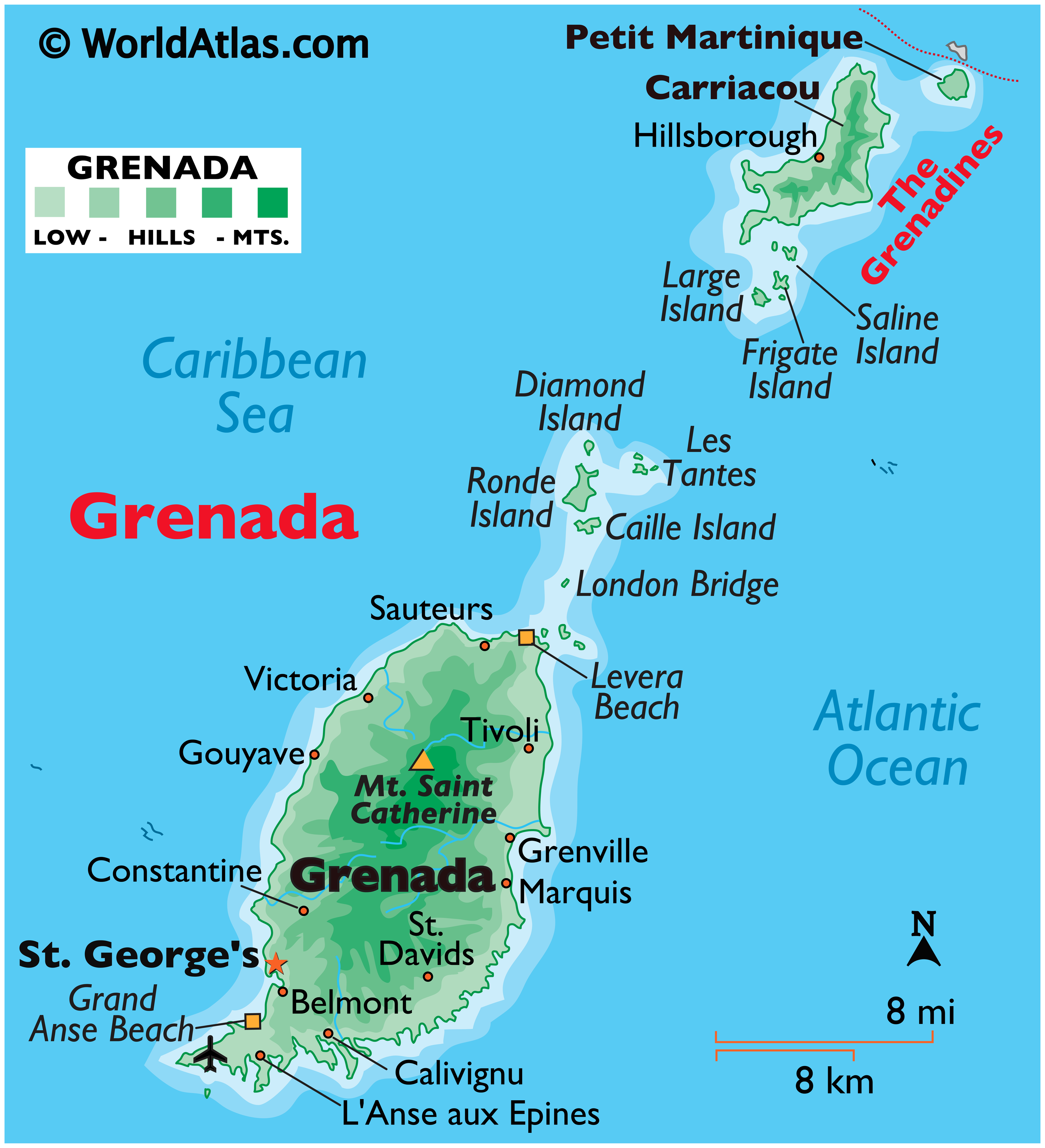
Grenada is a group of three larger islands (Grenada, Carriacou, and Petite Martinique) and several tiny islands in the Caribbean. It lies just north of Trinidad and Tobago, and southwest of Saint Vincent and the Grenadines. It is famous for spices and is known as the “Spice Isle”, being a major source of nutmeg, cloves, ginger, cinnamon, vanilla and cocoa.
Capital: St George’s
Currency: East Caribbean dollar “$” or “EC$” (XCD)US$1 ≈ EC$2.7 (pegged).
Population: 197,800
Language. English and English-based Creole.
Country Code: +1473
Visa: Most western countries visa free.
Climate. Average temperatures range from 24°C to 30°C, tempered by the steady and cooling trade winds. The driest season is between January and May. During the rainy season, from June to December, it rarely rains for more than an hour at a time and generally not every day.
Get In
By plane. Maurice Bishop International Airport (GND) in the extreme southwest 4 miles from St. George’s. Connections can be made on Liat via Trinidad and Barbados, and also from Barbados via SVG Airlines.
By boat. A large cruise ship terminal allows up to 4 ships to be docked at once.
Get Around. The town centre has several hilly, narrow streets.
By Taxi.
By Bus. The standard transportation are mini-vans for15-19 people. They are lively trips, with great music and a nice breeze.
By Car. Car rentals are expensive. A temporary Grenada license is obtained from the car rental company or police station for EC$30. Drive on the left and horn on blind corners.
By Boat. Water taxis between Cruise Terminal, Grand Anse Beach and the Carenage.
SEE & DO
Rent a car and drive around Grenada seeing as many NM sites as possible. Ferry to Cariacou? Historic forts, lakes, waterfalls, spice estates, spice gardens, floral gardens, rum distilleries, plantation houses, Amerindian petroglyphs.
GRENADA
St. GEORGE’S
“St. George’s University'” The School of Medicine opened in 1976 and now offers a range of graduate programs. The True Blue campus features breathtaking panoramic views of the south of island and is ideal for sunset viewing.
St. George’s Airport (GND)
St. GEORGE FORTIFIED SYSTEM. Tentative WHS (05/08/2004). Although a fort from the period of initial European settlement was already in existence the true start of the establishment of the St George’s Fortified System was arguably the construction of Fort George from 1706-1710. Over the course of the eighteenth century the defence system around St George’s gradually evolved on the ridges of the hills that enclose St. George’s and its natural harbour like a giant amphitheatre. In its heydays the system consisted of eight forts, designed to mitigate internal Amerindian attacks and slave uprisings, as well as external European rival invasions. At the time of their establishment, each fort progressively incorporated the latest design concepts to facilitate advancing technological achievements of the period, showing today the development of French .and British military engineering adjusted to Grenadian circumstances. The three major forts of the system have been preserved to the present day. Fort George is associated with all the periods of Grenada’s history up to its contemporary period, as the execution of Prime Minister Maurice Bishop in October 1983 was carried out at Fort George. The fort currently houses the Police Headquarters and Police Training School. Fort Frederick is restored and is open to the public. Fort Matthew was converted into a lunatic asylum to serve the entire Windward Island in 1880 and was abandoned in 1987 when a new asylum at Mt. Gay was opened. It is currently in a bad state of repair. The other military structures have either disappeared or fallen to ruins.
Fort Frederick high above the sea with outstanding views of St. George´s, Grand Anse, Grand Etang and the southern part of the island.
Fort George above the main town of St. George´s with a beautiful view of the town and the Carenage.
St. GEORGE HISTORIC DISTRICT. Tentative WHS (05/08/2004). The urban pattern has a planned part and an unplanned part, physically and visually partly separated by the ridge of a mountain on which the main landmarks of the town have been erected (Church Street) and as such has evolved as the spine of St George’s. The planned part of the town was laid out on a grid system with a central square and has developed predominantly over the course of the eighteenth century after fires had razed the town in 1771 and 1775, requiring buildings to be made of brick or masonry with clay tile roofs and laid out as detached units instead of row houses. The original urban plan has remained intact since then and a large body of Georgian architecture adjusted to Caribbean circumstances has been preserved.
The unplanned part has been shaped by the form of the natural harbour of St George’s and the contour lines of the surrounding hills and developed from the early nineteenth century onwards. Historic buildings here are mostly wood in a vernacular Caribbean style.
Grenada National Museum
St. George’s Anglican Church (St. Georges Parish Church).
St. Andrew’s Presbyterian Church
St. George’s Market Square nice Caribbean market with newly renovated spice market hall in St. George’s – great for spices and fresh fruits & vegetables.
St. John’s River. In north St George’s just south of Cricket stadium.
Underwater Sculptures, Molinere Bay. Bizzarium. Can dive or snorkel (free).
Saint Patrick parish (North). XL: Carib’s Leap* a historic place in the north of the island where the last Carib Indians jumped from a high cliff.
Levera Pond NP
Lake Antoine National Landmark. This crater lake is on Grenada’s eastern side about 6 miles north of the town of Grenville. Go north on the road to Tivoli. Turn east to La Poterie, then north across River Antoine. A narrow road will take you to Lake Antoine, a crater lake formed by the collapsed cone of a volcano. From the top of a hill you’ll have a fine overview of this perfectly shaped crater. Assuming the access path is in decent shape, take the track down and walk the perimeter of the shallow crater lake, which covers 16 acres.
Lake Antoine. The water level in Lake Antoine usually is no more than 20 feet above sea level. Although this is in a relatively dry, hot region of the island, it’s a good spot for birders. Snail kites, fulvous whistling-ducks, limpkins and grey kingbirds have been seen here.
River Antoine Rum Distillery is the oldest Rum Factory in the western hemisphere and still operating with a water wheel.
Grand Etang NP and Lake
Seven Sisters Waterfall is a group of 7 Waterfalls close to the Grand Etang Nature Reserve in St. Andrew.
Mt Carmel Falls the highest Waterfall in Grenada.
Spice Island Wildlife Sanctuary And Petting Zoo, Crochu. Children’s zoo is permanently closed.
La Sagesse Nature Centre. The former estate of the late Lord Brownlow, cousin to Queen Elizabeth II, this nature center occupies the entire length of La Sagesse Bay. Unfortunately, the trails through the property are in poor condition and hikes are no longer available. Packages are available including transfers to and from your hotel, a meal and access to the beach facilities. The on-site restaurant (mains EC$34 to EC$85) serves good Caribbean meals in a lovely waterside setting.
La Sagesse Beach
Palm Tree Gardens, Red Gate
Clarke’s Court Rum Distillery
Grand Anse the most famous beach in Grenada and in the tourist belt.
Magazine Beach
GRENADINES (Carriacou, Petite Martinique)
Grenadines Island Group. Tentative WHS (18/11/2013). The Grenadines are a group of 35 small islands located between Grenada and St. Vincent in the Windward Islands of the Lesser Antilles. They stretch over a distance of 90 km from the Island of London Bridge in the south to Bequia in the north. The natural boundary of the site approximates to the Grenadine Shelf, which is some 50m deep and falls off steeply in the Tobago Trough. Geographically, the area lies along the interface of the Caribbean and South American Tectonic plates. Several active undersea mounts (e.g. Kick’em Jenny) attest to the on-going movement of these plates.
The international boundary between Grenada and St. Vincent and the Grenadines runs east to west across the bank between Petit Martinique and Petit St. Vincent. Nonetheless, the links among all the Grenadine Islands on both sides of the boundary are historically strong and continue to be active. Fishing, informal trade, tourism and island social life proceed with little attention to the boundary. In both countries ‘mainlanders’ concede that the connections among the Grenadine islands are in most cases stronger than those with the main island.
Efforts by the two countries to conserve coral reef biodiversity can be seen as contributing to reef biodiversity conservation at the regional level.
In the Grenadines there are nine (9) islands with permanent settlements. The largest islands – Bequia, Mustique, Canouan, Mayreau, Union I., Petit Martinique and Carriacou, have towns and communities with public (schools, clinics, utilities) and private supporting infrastructure. Others are resort islands- Palm I, Petit St. Vincent. Most others are visited by yachters and fishers.
The islands of the Grenadines range from rocky volcanic headlands to tiny cays that barely rise above sea level. The largest islands are Carriacou in Grenada (3400 ha) and Bequia in St. Vincent (1800 ha). Although many of the islands are inhabited and used for agriculture and the surrounding waters for commercial fishing, much of the area still exists in a relatively undisturbed condition.
CARRIACOU
Carriacou Museum
Old Sugar Mill
Festivals: Carriacou Maroon and String Band Music Festival
PETITE MARTINIQUE XL:
DO
Festivals
Grenada Chocolate Festival
Grenada Drum Festival
Spice Mas Festival
Experiences: Try or Learn how to make rum
Gouyave Fish Friday. Gouyave, West Coast fishing village that never sleeps. Medical School. The food is fresh, inexpensive, music, lots of kids milling about, and the night ends in a party at various night clubs.
Diving & Snorkelling. First Underwater Sculpture Park in the world. Diving Capital of the Eastern Caribbean. Largest shipwreck in the Caribbean – the Bianca C – a 600 ft cruise ship which sunk in 1961, now lying in 167 feet of water. 50 sites, including reefs, wrecks and walls most within 5-15 minutes boat ride from the dive shops.
Get Married! Weddings are legal and you only need to be on island for 3 days (including weekends); beautiful and unusual wedding sites (beaches, waterfalls, forts).
Hashing a different trail is set each week anywhere around the island for walkers and runners. A great way to see the beauty of Grenada and meet locals and visitors. http://www.facebook.com/groups/grenadahash/ or http://grenadahash.com/ Be aware of the island’s steep slopes, heavy jungle and roads without shoulders.
Shopping. Rum, chocolate, honey, jams and jellies, spices, clothing and art.
Nutmeg is Grenada’s cash crop, so buy some form – whole, jam, jelly, syrup, Nutmed (medicinal ointment), nutmeg flavored ice cream. Hurricane Ivan in 2004, over 90% of Grenada’s nutmeg crop was destroyed. Other fine spices include mace, cinnamon, ginger, cloves, vanilla and turmeric.
Real vanilla pure form has a noticeable, dried vanilla beans (in pod)…an essential to a full range of kitchen herbs/spices.
Chocolate Grenada Chocolate one of the best in the world. Grenada Chocolate Factory. Produces organic dark chocolate with vintage machinery run by solar power.
Rum Rum distilleries three largest Clarke’s Court, Westerhall Estate and River Antoine.
