
The Archipelago of the Azores is an autonomous region of Portugal. and an ultra peripheral area of the European Union. Formed on the tips of barely submerged underwater mountains, the nine islands boast crater lakes, hot springs and spluttering geysers.
The first known inhabitants were Portuguese in the 15th century. The Azores became an important waypoint during the Age of Discovery.
The population of one quarter of a million residents live on these islands but more than two million live overseas, primarily in the United States (Channel Islands), Canada, Brazil, and mainland Europe. These nine volcanic islands are situated in the northern Atlantic, about 1,500 km (950 mi) from the western edge of the Iberian Peninsula and about 3,900 km (2,400 mi) from North America. Seismic activity, though rare, still occurs on occasion.
The archipelago is between 37° – 38° 55′, the same as Lisbon. It has a tepid, oceanic, subtropical climate, with mild annual oscillations. Weather can vary in one day from bright sunny, to rainy and back to sunny. Daily maximum temperatures 15 – 25°C. Rainfall increases from east to west with range of 700 – 1600mm reaching 6300 on Mount Pico, the highest Portuguese mountain at 2351 metres. If you want a beach holiday with plenty of sun, the Azores are not right for you.

ITINERARY
July 14 2021. Flights. Westjet Comox to Toronto 07:15. Azores Airlines S4332: Toronto 20:45 – Ponta Delgado 06:30 July 15
July 15, 16. SAO MIGUEL. rent car at airport.
Ponta Delgado. Museu Militar dos Acores, Forte de São Brás de Ponta Delgada, Igreja do Santo Cristo, Igreja Matriz do Sao Sebastiao, Mercado da Graça, Monumento ao Emigrante.
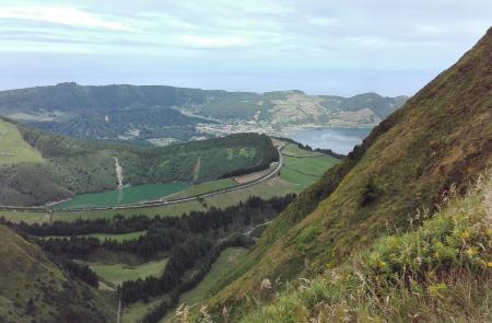
Sete Cidades. Drive (Camping. Sete Cidades Parque de Campismo) Vista do Rei viewpoint. Monte Palace Hotel, Lagoa do Canario. Sete Cidades
Trail: Mata do Canário – Sete Cidades
Ponta da Ferraria. Mosteiros swim, Casa de Pilatos
Ribeira Grande. Museu Casa do Arcano, Caldeira Velha. Pico do Barrosa. Lagoa do Fogo. Salto da Farinha waterfall. Ribeira dos Caldeirao Natural Park good waterfalls,
Furnas & Nordeste. Farol do Arnel. Miradauo da Ponta Sossego & Mirodouro da Ponta da Madrugada viewpoints. Hot spring of Caldeiras (tiny geysers, hot water creeks, strong sulphur). Terra Nostra Park. Furnas Lake.
July 16. fly TERCEIRA (regular flight at 20:05). Hostel. Central Zone of the Town of Angra do Heroismo WHS.
July 17. Monte Brasil*. Overlooking the city of Angra do Heroismo, this 7.5km loop trail starts at St John the Baptist fortress, Santo Antonio chapel, Pico do Facho viewpoint, Vigia da Baleia viewpoint and Pico das Cruzinhas viewpoint to the top. Do sunrise.
Museu de Angra do Heroismo, Se Cathedral Horta, Church of Santa Barbara
July 17. ferry PICO (Purple Line ferry leaves Praia Da Vitoria (on the east side of the island) at 13:40, arrives Madalena at 20:00, there are no direct flights)
Landscape of the Pico Island Vineyard Culture. World Heritage Site. Village of Criação Velha. Whaling Industry Museum, Gruta das Torres. (lava cave, up to 15m high and 5.2 km long).
July 18. Climb Mount Pico (2351m). Casa da Mntanha (1200m), the starting point, GPS tracks location constantly. Fee 10E + 2E Very steep hike, weather can be anything – warm sweaters, jackets, gloves and toques. 47 numbered poles.
Fly to Ponta Delgada (2 flights at 17:25 and 18:30).
July 19. Fly to Capo Verde
SEE
M@P: Flores and Corvo
Tentative WHS
Ilhas Selvagens (Selvagens Islands, Savage Islands) (31/07/2002) are a small Portuguese archipelago in the North Atlantic, 280kms south of Madeira, and 165 kilometres (105 mi) north of the Canary Islands. The archipelago includes two major islands, Selvagem Grande and Selvagem Pequena, each surrounded by a cluster of islets and reefs, with the total area of 2.73 km2. The archipelago is administered as part of the Portuguese municipality of Funchal, belongs to the Madeiran civil parish of Sé, and is the southernmost point of Portugal.
It was designated a natural reserve in 1971, recognising its role as a very important nesting point for several species of birds. Since then, the decreasing bird populations (namely Cory’s shearwater) and nearby waters have been more closely protected by the Portuguese government. Given its status, remoteness and few fresh water sources, the archipelago is today largely uninhabited. The only residents year-round are stationed on Selvagem Grande Island, which includes reserve staff and scientists conducting research on wildlife.
Mid-Atlantic Ridge. Tentative WHS. The mid ocean ridge systems are the largest geological features on the planet. The Mid-Atlantic Ridge (MAR) is a mostly underwater mountain range in the Atlantic Ocean that runs from 87°N -about 333km south of the North Pole- to subantarctic Bourvet island at 54°S. The MAR is about 3 km in height above the ocean floor and 1000 to 1500 km wide, has numerous transform faults and an axial rift valley along its length.
The ridge was discovered in the 1950s. Its discovery led to the theory of seafloor spreading and general acceptance of Wegener’s theory of continental drift. The MAR separates the North American Plate from the Eurasian Plate in the North Atlantic, and the South American Plate from the African Plate in the South Atlantic. These plates are still moving apart, so the Atlantic is growing at the ridge, at a rate of about 2.5 cm per year in an east-west direction.
Most of the ridge system is under water but forms land as a set of volcanic islands of varying size that run the length of the Atlantic Ocean. These islands are:
Jan Mayen (Norway)
Iceland
Azores (Portugal)
St Paul’s rock (Brazil)
Ascension Island (UK)
St Helena (UK)
Tristan da Cunha (UK)
Gough Island (UK)
Bouvet Island (Norway)
The following properties are inscribed on the World Heritage List, but not for their geological values of the sites; they were inscribed on the basis of cultural and/or natural criteria:
Þingvellir National Park, Iceland (2004 )
Landscape of the Pico Island Vineyard Culture Portugal (2004 )
Gough and Inaccessible Islands United Kingdom (1995 , 2004 )
Brazilian Atlantic Islands: Fernando de Noronha and Atol das Rocas Reserves (Brazil) (2001)
Sites of Globalization. Tentative WHS. Bring together a shared legacy based on heritage, linked to the routes of the Discoveries; the “New World” and the beginning of a new type of international trade and economic development; new geography and peoples; pioneering spirit, sailing and navigation; a new organisation of society and administration; new buildings (religious and defensive) and forms of artistic expression; cultural miscegenation and reciprocal influences, with the ocean being the main vehicle for the exchange of cultures and the progress of civilisations.
These different places linked by the sea included the west coast of Africa, support points in North Africa, Atlantic islands, and the creation an innovative marketplace/trading post.
The starting point of what was to become a new era for humanity.
Chronologically, beginning in 1415 with the occupation of Ceuta by the Portuguese, African coast – the Casa de Arguim (House of Arguin) and the Casa da Guiné (House of Guinea) – moved from Lagos to Lisbon; and it ended in 1481, when private initiative was finally replaced by an effective regal monopoly on overseas trade, which created the conditions for the Portuguese and Castilians to finally show the Atlantic to Europe and the world in the explorations of the 1490s. The phase of globalisation corresponding to the “Places of Globalisation” covers the opening up of the commercial routes between the extreme south of Portugal and the west coast of Africa and the human occupation (colonisation) of the Atlantic islands. This process can be sub-divided into the following phases:
The movement started with the conquest of Ceuta (1415), the key to the whole Mediterranean Sea, as Zurara wrote, a naval base for controlling the Strait of Gibraltar; and for the 14th century Arab historian, Ibn Khaldun, it was “the ideal starting point for people participating in the holy war”. The occupation of other strongholds in North Africa followed.
A period of pure Atlantic privateering by members of the house of Prince Henry and on his initiative, which led to the occupation of the uninhabited archipelagos of Madeira, Azores and Cape Verde, and several attempts to conquer the Canary Islands and to round Cape Bojador (1434). New products appeared, especially the cultivation of sugar cane in Madeira, starting in 1452, which opened up a new segment of international business, archaeological evidence of which has also been discovered in Silves.
From 1443 onwards, slave trade and the first commercially acquired gold dust (in 1442) contributed to the beginning of a new cycle in Atlantic navigation. The first public sale of slaves happened in 1444, in Lagos, where later was created the House of Guinea, and the archaeological findings at Vale da Gafaria provide evidence of this trade. Also related to this trade is the Fortress of Arguin (Mauritania), established in 1449. Along with this trade was the search for western gold routes.
The elements of heritage corresponding to the era of the first Portuguese overseas expeditions in the Atlantic represent exceptional evidence of the start of a new economic geography, which was very different to what had preceded it.
This period in history was the catalyst for new commercial areas for Europe and of the first real global international trade, which started in Lagos, continued in Lisbon, and was then continued by Castile and by the Spanish Monarchy in Seville and the Low Countries (Bruges, Antwerp); the process was concluded by the hegemony of the Dutch (Amsterdam) and the English (London), who renewed it with a new economic geopolitics, and from which they profited from the 17th century onwards. In Portugal, the Barlavento (western Algarve) became the “first quay” – as it was emphatically called by the philosopher Agostinho Silva, and it was joined by places in the archipelagos of Madeira and the Azores.
In the Azores, two geographic areas of particular importance were: Vila do Porto (Santa Maria) and Angra do Heroísmo (Terceira), which is already included in the World Heritage List.
Ferries between islands. With nine islands, traveling between them by ferry can be time consuming, especially on longer routes, so unless you prefer a slow-paced cruise we’d recommend flights as your preferred mode of transport.
Exceptions are the Triangle Group – Faial, Pico, and São Jorge (Faial and Pico are very close) and the Western Group – Flores and Corvo, both with ferries year-round.
There is only one ferry company that goes to every island: the Atlânticoline.
Blue Line – between Horta, Faial and Madalena, Pico several times a day, 30-minutes.
Green Line – between Faial and Pico Islands, but also to Velas on São Jorge. Each day has different routes and schedules.
Pink Line – between Santa Cruz das Flores or Lajes das Flores on Flores to the Village of Corvo on Corvo Island
Yellow Line. May to September because of the sea conditions between all islands except Corvo and it is your only option to travel between all islands if you don’t wish to take a plane.
Purple Line. Connects Faial Island, Pico and São Jorge to Terceira during summer
White Line. Connects the central group: Faial, Pico, São Jorge, Terceira and Graciosa Island from June to October.
Purchase tickets at the ferry terminal, through the Atlânticolone website or through Azores Getaways!
SÃO MIGUEL
The largest and main island. Where most flights arrive. rent car – 3 days following itinerary below. Ferry.
Free BBQs can be found all over Sao Miguel especially along the coastal roads at the Miradors or viewpoints with gardens, toilet, cold water taps, picnic tables and benches and piles of free wood for the BBQs. It is a great way for both locals and tourists to get together and eat out in the open air.
Camping on Sao Miguel. There are five campsites; two free and three low cost, about ten Euros a night for two people in a small tent. Two of the campsites are in the craters of volcanoes with spectacular views and the other three are near the coast, with beaches. All have showers (cold in the free ones) and free BBQs supplied with free wood.
Day 1. PONTA DELGADA the archipelago’s capital and largest city.
Museu Militar dos Acores
Forte de São Brás de Ponta Delgada
Igreja do Santo Cristo. The Cult of the Lord Holy Christ of the Miracles (Culto do Senhor Santo Cristo dos Milagres) is a religious veneration associated with an image of Jesus Christ, depicted in the events of the New Testament (Luke 23:1-25). The wooden image of Christ, by unknown artist, in a Renaissance-style representation of the Ecce Homo, represents the episode of Jesus of Nazareth’s life when the martyred religious figure was presented to the crowd following his whipping, and includes a crown of thorns, uncovered torso and bruised/beaten body. Narrated in the New Testament, the artist represented in grande artistic style the contrast between violence on the body and the serenity of the expression, emphasized by the gaze from the image.
Normally, this statue and piece of art is on display in the Sanctuary of the Lord Holy Christ, in the Convent of Our Lady of Hope, but annually leads a procession through the streets of the city on the fifth Sunday after Easter, and terminating on the Thursday of Ascension. The celebrations attract thousands of Azoreans, Luso-descendants and peoples from the various islands of the archipelago to São Miguel.
Igreja Matriz do Sao Sebastiao. 15th parish church and the Azores’s most colorful “Imperio,” a small chapel that is central to the religious festivals of the Holy Ghost (Espirito Santo) popular throughout the archipelago.
Mercado da Graça
Monumento ao Emigrante. The monument consists of concrete steles, stone mosaics and three life-sized bronze figures, showing an emigrant family that starts off into a better future. The father of the family points hopeful to the west – towards America.

Rent a car. 300+kms per day. Scooter problem with weather and much more tiring. Buses don’t reach the remote areas. Taxis very expensive. Roads good. Gravel road only to Lagoa do Congro. Local companies include Autatlantis or Micauto (avoid Ilha Verde). Rent on RentalCars.com. Book early especially in summer.
Drive West to Sete Cidades
Camping. Sete Cidades Parque de Campismo. Outside the small town of Sete Cidades. Free. One of the most beautiful places to camp in the world in the crater of the large Sete Cidades volcano with two famous iconic lakes in the crater. Separated by a land bridge, one lake is green, the other is blue. Basic with no reception or security, toilet with a sink, showers outside and basic, cold water only. May be young people using BBQ late.
An easy walk around the shores of the two lakes, or along the top rim of the volcano. Village has cafés, tea shops, bars and restaurants.
Vista do Rei viewpoint. Park short term parking if <20 minutes.
Monte Palace Hotel. Built in 70s, operational for only 2 years, entrance now forbidden. Supposed to reopen in 2023.
Miradouro da Boca do Inferno (Boca do Inferno Viewpoint). Spectacular wider view of entire crater. Take 2nd exit on way down to Sete Cidades village, 10 minutes signs to Lagoa do Canario. Near a set of stairs. 5 minute walk.
Lagoa do Canario. In small volcanic crater surrounded by dense forest. Access by turning left immediately after the entrance gate to Boca do Inferno.
Sete Cidades – huge caldera with two glittering twin green and blue lakes. Flanked by hydrangea-fringed walking trails and forest-blanketed cliffs, there are plenty of walking trails to hike around it – Vista do Rei on the crater rim is one of the best if you’re after views of the lake.

Trail: Mata do Canário – Sete Cidades – São Miguel****
TH: Mata do Canário, walks by the aqueduct (Muro das Nove Janelas, rebuilt in 1830 to supply Ponta Delgada), Mirodouro do cerrado das Freiras. Pico da Cruz viewpoint, along the east ridge of Sete Cidades to see the interior of the crater with its different lakes and volcanic formations and all the north coast of the island, and ends at the village of Sao Miguel. Linear, Medium, 11.8 km, – 3h00
Ponta da Ferraria. Small cove surrounded by a gigantic lava rock cliffs where the ocean is warmed by a natural spring. There is no beach. Be careful at low tide as can be very hot. Road very steep.
Mosteiros. Swim.
Casa de Pilatos, Seville. Self catering accommodation.
Continue Drive to North
Camping
Praia dos Moinhos Campsite. Small, free, on north coast in the village of Moinhos, a few miles west of Porto Formoso, midway between the larger towns of Ribeira Grande and Sao Bras. Hard to find, drive through the village to the large car park near the beach (Praia dos Moinhos). There is a car park sign but it is easy to miss. The camping field is behind the carpark. Facilities grim with cold showers, and toilets. Lovely black sand beach with a very relaxed looking bar / restaurant. 7km round walk through a beautiful valley and a beautiful waterfall and a lovely swim.
Parque de Campismo Quinta das Laranjeiras. Private, on north near Rabo da Peixe. Free wifi, electricity, small kitchen area. Opens for new check-ins after 6pm. 8€/person/day.
Museu Casa do Arcano, Ribeira Grande.
Salto do Cabrito. Easy 7.5km loop trail. Take the road towards Lombadas and Monte Escuro. Hop the chain fence to get access to Fajã do Redondo dam. Then, enjoy a walk surrounded by waters of Ribeira Grande. The forest track will be full of eucalyptus, acacia, and Japanese red cedar. You will pass by Faja do Redondo electricity museum. In the end, climb the stairs until you reach the Salto do Cabrito wonderful waterfall.
Caldeira Velha. Park with 2 hot springs, both stone walled and surround by lush foliage. The highlight is the waterfall spring (>20C) at the end of the park. Also a hotter 35 and shallowier pool. 8E
Pico do Barrosa. At the top of the road from Ponta Delgada and just before arriving at Lagoa do Fogo. Crater lake at the centre of Sao Miguel. Medium difficulty trail of 12 km. TH Praia, walk roads through farmland, forest, Levada irrigation channel, views of the Atlantic Ocean. Pass the valley of Ribeira da Praia, arrive at the bottom. See both the south and north coasts at the same time. Usually cloudy at the lake. 30-minute hike down to the beach but swimming not allowed.Return to Ribeira Grande and drive around north side of island.
Salto da Farinha. Nice waterfall located between Achadinha and Salga. From Achadinha take the local road to Salga (M521). After 2,5 Km, exit this road and take a narrow one (right side) until the parking of Miradourdo do Salto da Farinha (less than 500 m). Recommend parking and walk 10 minutes to the viewpoint.
Linear Medium 4.9 km 2h00
Ribeira dos Caldeirao Natural Park. Near road, great waterfalls,
Day 2. Furnas & Nordeste Wild and remote eastern part, steep cliffs, roads sinuous. Ancient Laurel forest and a beautiful coastal road with many beautiful “Miradors” – viewing points.
Camping
Furnas Campsite (Parque de Campismo das Furnas). Located in the town of Furnas in the crater of a large, extinct volcano. Restaurant/cafe, BBQ/kitchen, shower, laundry. Located on the slope of the volcano with views of the walls of the volcano, steam rising from the nearby hot sulphurous calderas, and in the valley below the pretty small town of Furnas. Drive your car in on arrival, unload and pitch your tent. After that, you are not allowed to take your car in.
Nordeste Campsite. Government owned on NE corner of island near town of Nordeste. 10 Euros per night. Busy in the peak summer months with Azorean families. Beach with an open air pool that fills with sea water at high tide. Nordeste has shops, cafes, supermarkets and a modern bus station with a café – a pleasant place to sit, enjoy a coffee and enjoy the spectacular sea view.
Farol do Arnel. Oldest lighthouse in Azores. Very steep road, best walked.
Miradauo da Ponta Sossego & Mirodouro da Ponta da Madrugada viewpoints.
Trail: Água Retorta – São Miguel***. This small circular route through the village of Água Retorta 500 inhabitants where people still preserve the old ways. Visit the ruins of an old windmill Circular Medium difficulty 4.8 km 2h
Salto do Prego. Sanguinho Trail in Faial da Terra, a sparsely populated, magical little village to Salto do Prego. Circular, Medium, 4.5 km, 2h00
Hot spring of Caldeiras (tiny geysers, hot water creeks, strong sulphur). Eat corn on cob cooked in the furnas. Find the upside house. Follow the creek to the camping park.
Terra Nostra Park. Historic botanical gardens planted in the 18th century and part of hotel. 6 different hot springs – swim in the hot springs at 40°C. Don’t be put off by the murky brown water due to mineral-infused water. 8E+rental towel and locker, ?free if have lunch at restaurant.
Furnas Lake. See the Nossa Senhora das Vitorias Neo-gothic church and Research Centre. On the opposite shore of the lagoon are fumarolas where the locals cook the famous Cozido das Furnas (Furnas stew) for about 6-7 hours. A mix of pork, veal, chicken, blood sausage and vegetables like sweet potato, kale or cabbage, quite bland and dry.
Vila Franca Islet. Home to a stage of the Red Bull Cliff Diving World Series, popular sunbathing place in almost full-circle bay perfect for swimming or snorkeling (sea shoes)/ Regular ferries. 8E. Small beach disappears with high tide. Use concrete platforms.
Lagos do Congro. Remote reached by 10-15 minute hike through forest, green water. Reach on dirt road through pastures for 5 minutes with entrance to hiking path on right.
Gorreana (tea plantations). Working since 1883, one of only two tea plantations in Europe. Black and green tea. Overlooks ocean. One hour to hike up to tea estate. Free tea.
Porto Formoso. Beach black sand.
Miradouro de Santa Iria. Viewpoint on north coast. Sunset.
Return to Ponta Delgada. Fly to Angra do Heroismo July 16 evening.
TERCEIRA
Third largest island. Requires a flight from Sao Miguel?
Purple Line. Connects Faial Island, Pico and São Jorge to Terceira during summer
White Line. Connects the central group: Faial, Pico, São Jorge, Terceira and Graciosa Island from June to October.
Yellow Line Ferry. May to September because of the sea conditions between all islands except Corvo. Only option to travel between all islands if you don’t wish to take a plane.
Algar do Carvão. Cave
ANGRA do HEROISMO
Central Zone of the Town of Angra do Heroismo. 16th century World Heritage village with a snug harbour protected by a volcanic cone that made the port a major staging point for European explorers on the way to the New World from the 16th to 18th centuries. Ships laden with riches often moved in convoys from Terceira to Europe to ward off pirate attacks.
Museu de Angra do Heroismo
Se Cathedral Horta: Church of Santa Barbara
Monte Brasil*. Overlooking the city of Angra do Heroismo, this 7.5km loop trail starts at St John the Baptist fortress, Santo Antonio chapel, Pico do Facho viewpoint, Vigia da Baleia viewpoint and Pico das Cruzinhas viewpoint to the top.
SAO JORGE fjord-like lakes, vineyards and banana, guava and coffee plantations thrive in the subtropical climate.
PICO
The second largest island reached by ferry from Faial to Madalena. Lava rock from ancient eruptions forms the walls of many homes and borders vineyards for the local wine, Verdelho.
Ferries
Blue Line – between Horta, Faial and Madalena, Pico several times a day, 30-minutes.
Green Line – between Faial and Pico Islands, but also to Velas on São Jorge. Each day has different routes and schedules.
Purple Line. Connects Faial Island, Pico and São Jorge to Terceira during summer
White Line.Connects the central group: Faial, Pico, São Jorge, Terceira and Graciosa Island from June to October.
Landscape of the Pico Island Vineyard Culture. World Heritage Site. The is a 987-ha site on the volcanic island of Pico, the second largest in the nine-island Azores archipelago. The extraordinarily beautiful man-made landscape of the site is the best remaining area of a once much more widespread practice. It is an outstanding example of the adaptation of farming practices to a remote and challenging environment. Pico Island is one of nine volcanic islands in the Azores with a long evidence of grape-growing and wine-making (viniculture), with an imposing pattern of orderly, long, linear walls running inland from, and parallel to, the rocky coastline around its northern and western edges. The stone walls form thousands of small, contiguous, rectangular plots built to protect crops from wind and salt spray. Vines were, and continue to be, planted within the small and soilless plots (locally called currais). The extensive system of small fields, as well as the buildings (manor houses, wine cellars, warehouses, conventional houses, and churches), pathways and wells, ports and ramps, were produced by generations of farmers enabling the production of wine.
Begun in the 15th century, wine production on Pico Island reached its peak in the 19th century and then gradually declined due to plant disease and desertification (loss of soil and reduced rainfall). However, a low level of grape vine growing and high-quality wine production continues to be undertaken and expanded, especially around the village of Criação Velha. Wine production is managed under a regime designed to ensure economic viability and sustainability as well as to retain traditional farming techniques.
Abandoned, stone-walled enclosures suffer from a low level of deterioration resulting from disuse and neglect, while certain invasive plants species have colonised many of -these abandoned currais.
Mount Pico (2351m). This perfectly cone-shaped.mountain is the third highest peak in the Atlantic Ocean and highest in Portugal. Climbing this dormant volcano is the ultimate Azorean challenge.
All climbers – with or without a guide – must check in at Casa da Mntanha at 1200m, the starting point for everyone. You are given a GPS and your location is tracked constantly. Fee in 2017 was 10E + 2E for Piquinho. It is basically a very steep hike with a wide range of hard rock and soil. Guides are suggested as they know the shortcuts, shelters in bad weather and best paths. Weather can be anything and change rapidly. Bring warm sweaters, jackets, gloves and toques.
Start early (6:30?). There are 47 numbered poles on the way to the peak – although after #44 you’re already on the crater with a 70m summit scramble to a mini-mountain called Piquinho, which may be the hardest part. There are no trees but all kinds of different kinds of lava, craters, and formations. 8-9 hours
Feel heat, steam escaping between the rocks, the stones are hot, the air is hot. The 360-degree views of the Atlantic and the nearby islands of Faial and Sao Jorge. Views are not usually clear. The floor of the crater has stone pits and shelters made by climbers to spend the night and see sunrise and sunset. Tents are mandatory if sleeping here.
Whaling Industry Museum details the historic transition of Pico from a whaling station to a renown place to see whales in the wild.
Gruta das Torres. A lava cave, a geological formation of volcanic origin formed from the flow and cooling of subterranean magma rivers. This formation is located outside the parish of Criação Velha in western Pico. The cave system formed from a series of pāhoehoe lava flows which originating from the Cabeço Bravo parasitic cone about 500 to 1500 years ago. The caves are a group of interconnected lava tubes between 0.5–22 metres (2–72 ft) width, created from both pāhoehoe and ʻaʻā types of lavas generated during different geological periods. It has a height between 1.1 and 15 metres (3.6–49 ft) and is located at an elevation of 300 metres (980 ft). With an estimated length of over 5.2 km (3.2 mi) it is the longest lava cave in the Azores.
The cave’s uniqueness lies in its impressive drainage pattern, which can be shown by the presence of more than seven layers on the walls, with lateral benches and three cornices. The first scientific exploration was in 1990.
The lava tubes have picturesque formations of stalactites (lavacicles), stalagmites, lava, lava benches and side balls or balls of lava.
They are humid as water drips from the roof and a constant temperature of 16 °C (61 °F) is recorded throughout the year. The total drop is approximately 200 m (660 ft).
The tunnels formed within a pāhoehoe type lava flow. The top of the flow cooled against the air and formed a solid crust, while beneath it the liquid lava continued to move. As the amount of liquid lava passing through them decreased, the tunnels emptied.
The first 450 metres (1,480 ft) are accessible to visitors accompanied by a guide. Groups of 15 with a helmet fitted with lamps.
FAIAL
Fly to Horta
Blue Line – between Horta, Faial and Madalena, Pico several times a day, 30-minutes.
Green Line – between Faial and Pico Islands, but also to Velas on São Jorge. Each day has different routes and schedules.
Purple Line. Connects Faial Island, Pico and São Jorge to Terceira during summer
White Line. Connects the central group: Faial, Pico, São Jorge, Terceira and Graciosa Island from June to October.
Horta has been a hub for centuries of sailors, explorers, pirates, whalers and today’s trans-Atlantic yachtsmen. Despite its formidable 16th century fortress, both the Spanish and England’s Sir Walter Raleigh attacked Horta. During the pre-wireless days, Horta was a strategic relay point for the trans-Atlantic cable communications. Today see the maritime legacy, Horta Museum, Church of Santa Barbara
Faial Botanical Gardens
Faial Capelinhos Volcano. Drive over the Valley of Flamengos, on to Caldeira, the highest point on the island, and north to Capelinhos, the site of the most recent volcanic eruption in the Azores in 1957-58. The offshore event added two square kilometres to the island. The extensive ash fields and earthquake aftershocks caused so much damage that many islanders emigrated to North America.
Trail – Caldeira-Faial*. Easy 7km loop trail located in the middle of the island. TH Caldeira viewpoint. Cross the small access tunnel to the crater. Enjoy the view over the north and west coast. Climb until Cabeço Gordo, the highest point of the trail of 1,043 m.
FLORES
Considered the most beautiful of the Azorean Isles, Flores’ landscape is spectacular, featuring craggy cliffs, lakes and craters, waterfalls (Cascata do Poço do Bacalhau), small pastures bordered by miles of hydrangea hedges and stunning vistas of every imaginable shade of green.
Sanra Cruz das Flores: Flores Museum, Lighthouse of Ponta do Albernaz
Drive to several scenic lookouts Ribeira da Cruz, Fajazinha, Ponta da Faja and Caveira,
Rocha dos Bordoes a lava formation creating oddly high vertical flutes.
CORVO
Tiny island near Flores with 468 residents, a unique culture, dialect and a 16th century church, Azore’s famous windmills.
Pink Line Ferry – between Santa Cruz das Flores or Lajes das Flores on Flores to the Village of Corvo on Corvo Island
Windmills, Vila do Corvo
Caldera Corvo (Caldeirao). Lake
Get In
COVID Restrictions. The Azores are part of Portugal and thereby of the European Union and Schengen Area. They follow the rules imposed by mainland Portugal.
Rules change regularly.
By plane.The main entry point is Ponta Delgada Airport (PDL) on São Miguel. International airports are also on Faial, Flores (FLW), Santa Maria, Terceira islands. Also Pico airport (PIX).
azoresairlines.pt/en SATA International (flights from Toronto direct to Azores $400).
By boat. The Azores are a common stopover for small craft crossing the Atlantic, especially when crossing from west to east. There are facilities for small craft in Lajes das Flores on Flores, in Horta on Faial, in Ponta Delgada on São Miguel, in Angra do Heroismo and Praia da Vitória on Terceira, and on Santa Maria (all of these ports of entry). It may be possible to join a crew for the voyage.
The Azores are also a waypoint for many cruise ships on transatlantic routes.
Get Around. SATA Air Azores has flights between each of the islands, faster but more expensive than the ferry. The cost for each flight is capped at around €90. *Flying is the only way to travel between the eastern, western and central island groups during low season. Anyone flying from mainland Portugal, or Funchal, are eligible for a free connecting flight to any of the islands. The free flight must be arranged at least 7 days in advance and can be booked through the SATA Air Açores website.
Ferries connect each of the islands with regular lines and two lines that operate only in the high season.
Hitch-hiking is easy as Azoreans readily pick up hitch-hikers and given the poor bus service, hitch-hiking is often the easiest way to get around for those without a car.
Scooters may be the easiest way to get around. Cycling around the islands is possible if you are in great shape, and don’t mind a lot of hill climbing.
Language. Official language Portuguese. Most people involved with tourism speak English.
Accommodation. Camp-sites are available on every island – well equipped and cheap or free. See the VisitAzores website. There are few hostels outside of Ponta Delgada, often fully booked in high season.
DO
Many activities and sights are accessible only through private tour companies – €50-60 and to €100.
Hiking. Best on Flores, Sao Jorge and Sao Miguel. Volcano Climbing at Pico island. trails.visitazores.com. Visit the website and download the map as the “Trail Leaflet” to your phone. Download the Azores hiking trail app. It’s incredibly useful because you can download all the maps and use them freely offline.
Whale and dolphin watching. Every town with a marina offers whale watching in small boats, often within ten yards of the whale. The nutrient-rich water that laps the Azores attracts around a third of the world’s whales, dolphins and porpoises. Visibility reaches 30m in May and October. See Fin, Sperm and the elusive Blue whale.
Swim with Dolphins. Best to take a class with a local marine biologist.
Other Activities: Sailing, Off-road mountain bike circuits, Moto 4 Rides, Bird Watching, Donkey Rides, Fishing, Sport Fishing, Yachting, Diving
Go Next: Capo Verde – 3 direct flights a week from Azores.
Madeira/Funchal (FNC) bintercanaries.com/en to Los Palmas Gran Canaria, Lisbon/Lisboa (LIS), Porto/Oporto (OPO).
++++++++++++++++++++++++++++++++++++++++++++++++++++++++++++++++++++NOMAD MANIA Portugal – Azores (Ponta Delgada)
World Heritage Sites
Central Zone of the Town of Angra do Heroismo in the Azores
Landscape of the Pico Island Vineyard Culture
Tentative WHS
Ilhas Selvagens (Selvagens Islands) (31/07/2002)
Mid-Atlantic Ridge
Sites of Globalization
Borders: Azores (sea border/port)
Islands
SÃO MIGUEL
Museums: Ribeira Grande: Museu Casa do Arcano
Castles, Palaces, Forts: Seville: Casa de Pilatos
Botanical Gardens: Furnas: Terra Nostra Gardens
World of Nature: Ribeira dos Caldeiroes Natural Park
Waterfalls:
Salto da Farinha
Salto do Cabrito
Salto do Prego
Lakes:
Lagoa do Fogo
Lagoa das Sete Cidades
Well-being: Springs: São Miguel Thermal Pools (3 areas?)
PONTA DELGADA
Airports: Ponta Delgada (PDL)
Museums: Museu Militar dos Acores
Castles, Palaces, Forts: Forte de São Brás de Ponta Delgada|
Religious Temples:
Igreja Matriz do Sao Sebastiao
Igreja do Santo Cristo (Church of the Holy Christ, Santuario do Senhor Santo Cristo dos Milagres)
Markets: Mercado da Graça
TERCEIRA
Airports: Terceira (TER)
Caves: Algar do Carvão
ANGRA do HEROISMO Villages and Small Towns
World Heritage Sites: Central Zone of the Town of Angra do Heroismo in the Azores
Museums: Museu de Angra do Heroismo
Religious Temples: Se Cathedral Horta: Church of Santa Barbara
PICO
World Heritage Sites: Landscape of the Pico Island Vineyard Culture|
Museums: Whaling Industry Museum (Museo dos Baleeiros)
Caves: Gruta das Torres
Maritime/Ship Museums: Whaling Industry Museum
FAIAL
Botanical Gardens: Faial Botanical Gardens
HORTA
Airports: Horta (HOR)
Museums: Horta Museum (?Museu da Cidade da Horta). History of Horta
Maritime/Ship Museums: Fabrica da Baleia (Whale Factory Museum)
FLORES
Waterfalls:
Cascata do Poço do Bacalhau
Cascata da Ribeira do Ferreiro
SANTA CRUZ das FLORES
Museums: Flores Museum
Lighthouses: Lighthouse of Ponta do Albernaz (Farol do Arnel)
CORVO
Windmills: Vila do Corvo: Windmills
Lakes: Caldera Corvo (Caldeirao)
SÃO JORGE
GRACIOSA
SANTA MARIA
Beaches: Praia Formosa
