
Pend Oreille Canyon (spelt Pend d’Oreille in Canada) is a 209 km river that flows through north Idaho, into NE Washington and then crosses into Canada for several kilometres before joining the Columbia River just above the US/Canada border. After the Snake River, it is the largest tributary of the Columbia. The Pend Oreille River Water Trail has been formed to encourage the use of the river for recreational purposes. Maps for the entire trail can be seen on the website www.porta-us.com/pages/water-trail.
Remember, this is in the US, and you need your passports.
The most interesting part of the water trail is the Z Canyon – the 19 km from the town of Metaline Falls to the Boundary Dam just before the border in NE Washington. Here, it forms a beautiful canyon that has no road access until the dam.
Drive Boundary Road (exits Highway 31 in Metaline Falls) that leads to the Boundary Dam, and leave a vehicle to shuttle back to your car at the end of the trip. The best launch site is at Metaline Waterfront Park in Metaline Falls. The reservoir of the Boundary Dam extends upstream from here.
Metalline Falls. Cross under the bridge and go over the submerged Metaline Falls, which can have very high velocity and turbulence. The hydraulics here can be dangerous at any time of year. Scout the waves and powerful eddies from the bridge before launching. If they’re over your head, pick a downstream launching point on the east side of the river just below the falls at Deadman’s Eddy. One can also put in at the dam and paddle up the lake and return the same way.
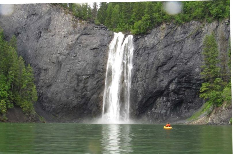
The highlight of the canyon is Pee Wee Falls, a beautiful waterfall that falls over a cliff into the reservoir. This photo shows Peewee Falls still running pretty big in June. It drops down to a trickle you can almost boat under in August of dry summers. You can reach the falls in an out-and-back trip from Boundary Dam Campground.
There is also a very odd cave at lake level on the north side (must duck down to get into it) that has a resident beaver.
You can visit the website to find the campsites on the reservoir if you’re interested in a more extended stay.
Box Canyon Dam is a gravity-type hydroelectric dam built in 1956. It has a capacity of 90 MW and an average expected production of 60 MW. The reservoir extends 55 miles (89 km). The dam is 160 feet (49 m) wide and 62.4 feet (19.0 m) high at the top of the gates. The maximum head of water is 46 feet (14 m).
It produces power using four Kaplan turbines. An upgrade completed in 2015 brought the dam’s rated capacity up to 90 MW from the original 69 MW.
Boundary Dam is a concrete arch gravity-type hydroelectric dam, finished in 1967, just south of the border with British Columbia. Seattle City Light operates it and makes up a significant portion of the City of Seattle’s energy portfolio. On average, it provides upwards of 46% of the power generated by Seattle City Light.
Boundary Powerhouse, located adjacent to the dam, is entirely built inside the rock that makes up the left abutment of the dam itself. It has a nameplate capacity of just over 1 gigawatt of generation.
A portion of the Kevin Costner film The Postman was filmed on the front of the dam. For some time in 1997, the dam’s face had a facade of a town (Bridge City in the film).
In the spring, don’t miss the dam tour – the spillways during spring runoff are spectacular.
