
Arrow Lakes is a 207 km long lake formed by the Hugh Keenleyside Dam just above Castlegar. It lies between the Monashee Mountains to the west and the Selkirks to the east. The lake level fluctuates 37 feet between low water in April and high water in early July. In 2012, with a massive snowpack and the wettest spring in history, the lake was allowed to go 2 feet above high water. Most beaches disappear, and thus camping recommendations are limited to the few sites above this level. When water levels drop, many gorgeous sandy beaches appear. The water is quite warm in summer, and swimming is good. The lake is divided into Upper and Lower, with the Narrows, just south of Nakusp, separating them.
History. Before the Columbia River Treaty and the Hugh Keenleyside Dam on Lower Arrow Lake at Castlegar, the Upper and Lower Arrow Lakes were separated by a 32km (20-mile) section where the Columbia River narrowed. When the gates of the Hugh Keenleyside Dam were lowered in midsummer 1969, the rising waters spread over the hamlets of Deer Park, Renata, Farquier, Needles, Edgewood and Burton as well as hundreds of summer homes and favourite fishing holes. Buildings had been removed or burned before the reservoir was filled, while residents either moved away or reestablished themselves above the floodwaters.
UPPER ARROW LAKE. This 85km long section extends in the north from the town of Revelstoke on the Trans Canada highway to McDonald Creek PP. Launch just south of the centre of the city. Highway 23 parallels the west shore as far as the Shelter Bay Ferry, after which it is on the east side. The highway is not close to the beach, and when paddling, one feels like they are in the wilderness. Upper Arrow Lake is covered by the 1:50,000 maps from north to south, L16, K12, K5, and K4. Upper Arrow Lake ends at McDonald Creek PP, 10km south of Nakusp, just above the Narrows. I will list potential campsites with the distance from Revelstoke (even though they may not exist at high water, but many appear as the water level drops).
Camp. 16km east. 50°51’36.8″N 118°05’47.3″W. It is a lovely beach on the north side of a prominent point.
Arrow Head. 31km east. Arrowhead was established by the Canadian Pacific Railway in 1895, the end of the line from Revelstoke, 24 miles south where the Columbia River widened into the Upper Arrow Lake, on the east shore. It was a transportation hub for miners and loggers heading into the Lardeau area. By 1905, it had two massive sawmills, two hotels, general stores, a drug store, a cigar store, ice-cream parlour, two churches, and a two-roomed schoolhouse. Only the cemetery remains 50.69717, -117.93056. When the valley was being cleared prior to the opening of the Hugh Keenleyside Dam, even those whose homes would not be affected by reservoir flooding were bought out and forced to leave. The government of B.C. did not want to provide roads, bridges, or ferry transportation to the former community. The only access is by boat.
The small community of Beaton is 16km up the arm and offers little of interest.
Shelter Bay PP. 38km. This is the west side of the free ferry and has a boat launch at the Arrow Lakes Picnic Area 50°38’14.6″N 117°55’29.2″W. There is no campsite, and in the summer, many people are waiting for the ferry. This 5km long ferry ends at Galena Bay on the east side.
Eagle Bay Rec Site. 45km west. 50°33’59.6″N 117°57’03.1″W. This is a nice boat access site with wind protection on either side of the point. Picnic tables are on the south side at the main site.
Halcion Hot Springs. 50km. 50°31’04.2″N 117°54’03.6″W. This is a resort on the east side with a restaurant, a hot spring and non-primitive camping.
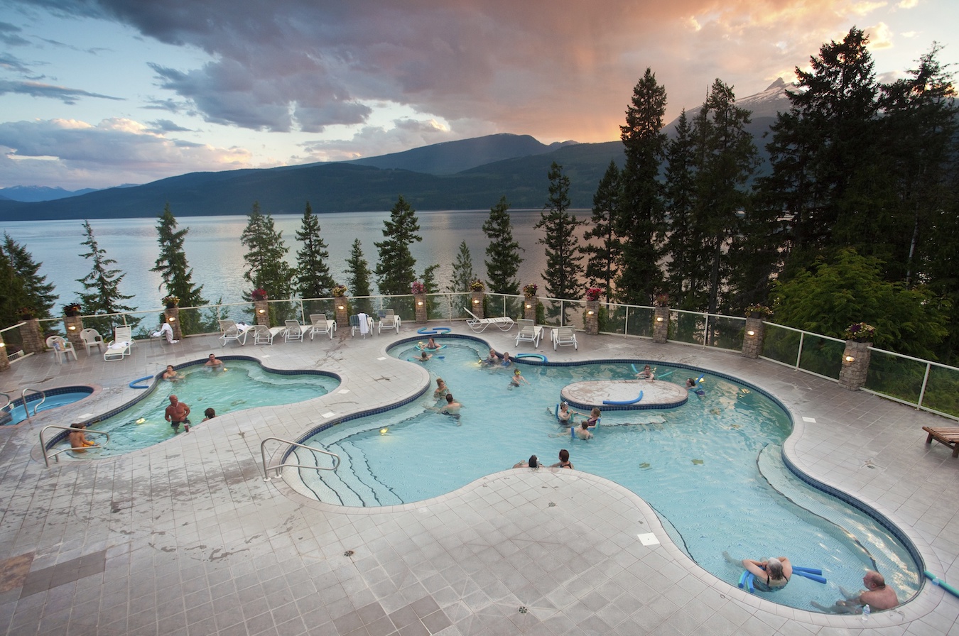
History. Halcyon was developed by Captain George Sanderson, who arrived in the early 1880s. He erected a small building around a plunge, to which a wooden pipe brought hot water down the hillside. Adding a stove and bar, he called it Halcyon, signifying health and happiness. The hotel was purchased by the BA Corporation, which was also operating the Rossland mines. In addition, cottages and bottling works were added. It revived after WWI and Prohibition and was bought by the White Cross and managed by General Burnham. The hotel was completely renovated and filled with the general’s family treasures. Cottages and a series of hot baths drew thousands for over 35 years despite the only access being by the sternwheeler Minto. As the vessel pulled into the dock, it was greeted by the General, two black spaniels, and Old Mule Jack, who hauled luggage up from the wharf. In 1955, while lighting the kitchen stove, Burnham spilled oil, and the hotel, all its treasures, and the General himself were consumed in the fire.
Camp. 58 km west. 50.452928, -117.957669. This is a good campsite, especially if the wind is from the north.
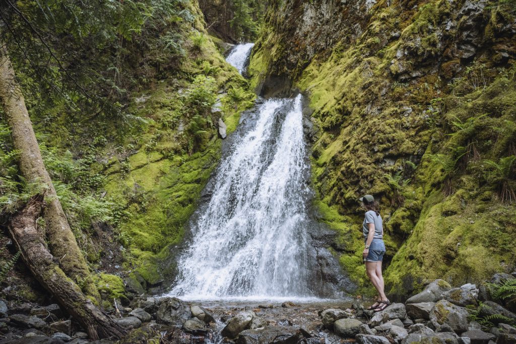
Pingston Creek. 60 km west. 50.438273, -117.954433. A great place to primitive camp near a beautiful waterfall. There is good protection from a south wind here. A good launch point is at a log dump south of Halfway River across the lake.
![[IMG_0275.JPG]](https://1.bp.blogspot.com/_JTjO2rqD-3E/SGKTj4kdJtI/AAAAAAAAAJQ/xGvZ3IXbiTc/s1600/IMG_0275.JPG)
Camp. 67km west. 50.376366, -117.939584. A lovely beach campsite.
Fostall Creek. 69km west. 50.361695, -117.938793. This creek has another beautiful waterfall close to the lake with good camping. There is a trail to the falls and several houses just south of the falls.
Nakusp. 85km. A small community (pop. 1600) on the east shore with all services. The Burger Hut at the southeast corner of town has excellent food. This is a good place to launch with free close parking. Nakusp Hot Springs is a short drive east of town. Nakusp is a hotbed of wild mushroom picking. Visible SW of the city is one of the best hikes in the area to the top of Saddle Mountain. There is a ferry at the lower end of the Narrows. From the lake, access is a little cumbersome with a possible bushwack to the gravel road that parallels the shore and then a 4.5km walk up a road to the parking area to start the hike. Views from the top are spectacular.
McDonald Creek PP. 85km east. This is a full-service campground with several kilometres of sandy beach, many waterfront sites, grassy meadows, and a boat launch. Reservations are recommended in the summer. 50.132824, -117.810357
LOWER ARROW LAKE
It is 122 km from McDonald Creek PP to the Hugh Keenleyside Dam. I have included the Narrows in the description of this part of Arrow Lake. All distances are from McDonald Creek PP. The 1:50,000 maps that cover the lake are 82K/4, 82F/13, 82E/16, E/9, E/8, and 82F/5.
Arrow Park Ferry. 10 km. To Saddle Mountain Lookout Trail.
Needles Ferry. 44 km. N49°52,33’ W118°04.81’. This is a free ferry on Highway 6. The town of Fauquier on the east side has a nice 9-hole golf course, school, beach, and campgrounds and is a modern, pleasant community.
Tate Creek Recreation Site. 53km east. 49.796505, -118.089460. This is a small forested campsite with sunny exposure and a good beach at low water.
Edgewood. 56km west. N49°46.69’ W118°08.25’. This is a small community with most services. This is the end of the road on this side of the lake.
Arrow Lakes Provincial Park Eagle Creek Site is immediately south of the town of Edgewood. 49.774374, -118.141057
Octopus Creek. 59km east. 49.748756, -118.112739. This is a small open campsite at the end of the road on the east side. There is no road access to Lower Arrow Lake for 17 km.
Island Point Recreation Site. 74km east. 49.615554, -118.132078. This site is just north of Hutchison Creek.
Blackberry Beach. 76km east. 49.598249, -118.131018. A nice beach site at low water.
Pebble Beach Recreation Site. 78km east. 49.552106, -118.119822.
Sunshine Bay Recreation Site. 82km east. 49.537932, -118.120243’. This is a small, forested campsite that a very rough road can barely access. There is a good beach at low water.
Two-Bit Creek. First cabins with road access. 49.519661, -118.115523
Bowman Point Recreation Site. 84km west. 49.530411, -118.150522. This is a small, treed, boat-access-only site with a sheltered anchorage.
Beacon visible for a long ways in both directions. 49.526237, -118.145125
Renata. 96km west. Launch from 49.436571, -118.079227. Best beach landing 49.432701, -118.101968. This excellent fruit-growing town was mostly abandoned (there are still a few residents) after it was flooded when the Hugh Keenleyside Dam was built, forming Lower Arrow Lake.
History. On the fertile delta of Dog Creek, it was protected from cold winds by gently rounded mountains and watered by two creeks. In 1887, 3 French Canadian prospectors built a log hotel. In 1907, the land was acquired by the Western Land Company of Winnipeg and subdivided into orchards. The name was changed from Dog Creek to Renata, and soon 20 homesteads dotted the flat. The first settlers were mostly of German origin – Mennonites from Saskatchewan and Manitoba. Others followed, and they all banded together to form a cooperative for packing, selling, and shipping fruit. They also built an irrigation system laboriously making pipes by boring holes through logs, and a sawmill to make fruit boxes. During peak years, thousands of pounds of cherries, peaches, pears, and apples were shipped – all by water, as there was no road after the Minto docked for the last time in 1954, a three-car cable ferry connected with the Deer Park road.
Among the 150 or so residents were half a dozen different religious denominations (Mennonite, Catholic, Salvation Army, Presbyterian, and Lutheran), each holding services in the schoolhouse. Finally, in 1954, the Pentecostals remodelled a house into the Living Waters Chapel.
When the houses and buildings of Renata were burned before flooding, the citizens placed a plaque in the Robson cemetery in memory of the pioneer residents.
“This plaque commemorates the community of Renata and its 58 former residents who lie beneath the water of the Arrow Reservoir”.
Across the lake is a boat launch 49.436571, -118.079227 used by the residents of Renata to access their homes. Road access is difficult. There are two good hikes here to waterfalls on Faith Creek and Dog Creek.
Natural Arch. 100km west. 49.404328, -118.071810. This amazing geological formation is the largest arch in Canada, measuring 3m wide and 6m thick, and stretching 45m across the gully. It is 34 m from the top of the arch to the ground. It is accessed only by boat from Deer Park 49.415574, -118.035248. Land on the beach in front of several homes in Brooklyn at the mouth of Pup Creek. The Natural Arch trail is 1.5km long and ascends 250m.
It is a bridge, not an arch, as it is formed by running water.
Brooklyn History. In the spring of 1898, the CPR decided to build an extension of the Columbia & Western Railway from Robson to Midway, 161 km to the west in Boundary Country. The construction company picked a site on Lower Arrow Lake, 48 km from Robson, as its headquarters, calling it Brooklyn. Equipment was brought by sternwheeler and barge while camps were established along the lakeshore so that work could proceed in both directions. A suitable pass through the nearby 8,000-foot Rossland Range which separates the Columbia Valley from Christina Lake had been found up Brooklyn Creek to the watershed of Dog and McCrae Creeks and down the latter to Christina Lake where Cascade City was born (with the settlements of Gladstone, Paulson, and Coryell briefly flashing into life only to vanish when construction had passed).
Brooklyn was on a point of land on claims belonging to William Parker. He had grown poor working his mining claims, but now his lots sold for up to $50 and then $200 as speculators, business people, workers, and others flooded in from all over the Northwest. JS Peterson from Trail built the 2-story Crown Point Hotel. The Brooklyn News appeared 5 days after the town was born. A wharf and warehouse were built on the water, bunkhouses for workers, a hospital, and a jail with room for a court and two cells. Life in Brooklyn was hectic.
Through the summer, the railway curved along sheer cliffs, climbing steadily. When it reached Brooklyn, it was 1,000 feet above the town. Here, it left Lower Arrow Lake to enter Dog Creek. As work progressed, stopping places appeared as shelters, a bar, and a hotel at Paulson, Gladstone, and Coryell.
For Brooklyn, its life had ended even before the railway was completed. When the construction crews moved westward, they were followed by the saloon keepers and shop owners who stripped the buildings of doors and windows. In Sept 1899, the remains of Brooklyn burned to ashes. Only 2 months later, a visitor “went to the spot where the town had been and then almost wondered if he had dreamed of there having been such a place”. Parker’s claim became a lonely clearing in the forest, and he was as poor as before the railway. In 1910, a development company planted fruit trees, but the project failed. W Schneider bought it in 1922 and farmed until 1958. Today, the farm and site lie below the reservoir.
Deer Park. This community, which has no services, has many cottages and a few permanent residents. The gravel road access is good. Across the lake is the beautiful rail trail, the start of the Kettle Valley Railway rail trail that starts at Castlegar and ends in Hope, BC. It climbs steadily from Castlegar, has several nice trestles and after turning south, goes through a kilometre-long tunnel.
History. Originally an Indian camping ground, it was born in 1896 when ES Topping and the 3 Petersen brothers of Trail, lured by mineral deposits, purchased 1,800 acres. In 1898, with the construction of the railway across the lake, a boom started. The Bates brothers built the Grand View Hotel, and Mrs. Luxton’s bakery turned out 1.000 loaves a day for Brooklyn. Sporadic mining, farming, and cutting cordwood for Arrow Lakes stern wheel steamers provided some work. In 1907, a school opened with 10 students. In 1912, a group of Mennonites built a church. But little change occurred, as for over 50 years it was accessible only by water. Finally, a road was built in 1954, but it was only a few years before it flooded, too.
Tulip Creek Falls. 109km north. 49.370041, -117.927958. This is a gorgeous waterfall, a short walk from the beach.
Syringa Creek PP. 113km north. N49°20.98’ E117°53.15’. This park has a large campground that is very popular in the summer, and reservations are recommended. There is an excellent beach at low water. One kilometre past the campground (east) is the Syringa Creek PP boat launch with good parking 49.341785, -117.871852. This would be a good take-out for any trip. From here on, there are many signs of civilization, with first a yacht club and marina, a subdivision, and then Scotties Marina, all on the north side.
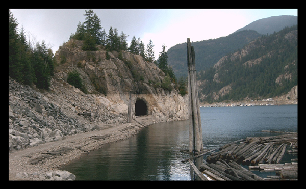
Labarthe Tunnel. Before the Hugh Keenleyside Dam flooded the Arrow Lakes in the 1960s, and the CPR’s Columbia & Western line was relocated, the Labarthe Tunnel passed through a rock bluff for 187 feet (57 metres).
It is a 20-minute paddle from Scotties Marina, easily seen from both ends of a bluff at 49°20’8″N 117°48’32″W.
To reach it from land, follow Arrow Lakes Drive west outside Castlegar past Hugh Keenleyside Dam and park at N 49°20.097 W117°46.891 and then follow the abandoned railway line for less than 3 km. Follow a trail that leads down from the rail bed to the tunnel. When the water level is low (early spring, late fall), the tunnel is dry, and you may walk through it. Conversely, when the water level is high, the tunnel may only be passed through with a boat or canoe. The tunnel may be submerged during very high water, but that hasn’t happened in years. The picture below shows the tunnel during low water.
Hugh Keenleyside Dam. 122km. It is possible to boat across the dam through a lock. Phone 250 365-3115 to contact the dam staff. A powerhouse has been added to the dam on the north side.
Originally known as the High Arrow Dam, it was a flood control dam spanning the Columbia River, 12 km (6.5 miles) upstream of the city of Castlegar. The dam is at the outflow of what was the upper and lower Arrow Lakes; today, the two lakes are joined, forming one long reservoir extending 232 km (144 mi) north to Revelstoke Dam, and contains 8.76 km3 (7.1 MAF) of reservoir volume. BC Hydro operates the dam.
The 853.4 m (2,800 ft) long earth fill and concrete dam was built as part of Canada’s role in the Columbia River Treaty. Along with the Duncan Dam, both were built to prevent flooding and to control the flow of water in the Columbia River for downstream hydroelectric dams. It was commissioned on October 10, 1968, six months ahead of schedule.
Immediately downstream of the dam is a 185-megawatt hydroelectric powerhouse, the Arrow Lakes Generating Station, which was begun in 1999 and completed in 2002. The Columbia Power Corporation owns the station.
Lower Arrow Lake was raised 12 metres (40 feet) above the natural levels, resulting in several towns being dismantled and relocated before their sites were flooded, including Burton. The dam was named after Hugh Llewellyn Keenleyside, the Canadian ambassador to Mexico (1944–1947). Hugh Keenleyside served as the chairman of the British Columbia Power Commission and co-chairman at the British Columbia Hydro and Power Authority from 1962 to 1969.
The Arrow Lakes reservoir is described by BC Hydro as a “great waterway for boating”, despite the effect that the 20 m (66 ft) difference between high and low water has on docks and ramps. The dam is equipped with a navigation lock, which is available at no charge to boaters. However, commercial traffic and floating logs have priority over leisure craft.
Robson and Castlegar. Past the dam is the community of Robson on the north shore. On the south coast is a pulp mill, a sawmill and then the city of Castlegar with a complete range of services, including an airport.
It would be possible to take out in Millennium Park in Castlegar. Two great hikes (Mt Sentinel Grind and Brilliant Overlook) give tremendous views west up to Arrow Lake, east up the Kootenay River, south down the Columbia, and of Castlegar.
Columbia River past the dam. This is one of the only free-flowing sections of the Columbia River left. Fishing here is world-class with mammoth sturgeon, walleye, and trout. It is a nice paddle with some riffles to the city of Trail, past which are some significant rapids. Lake Roosevelt at high water starts at the US border.
