
A glacial erratic is glacially-deposited rock differing from the size and type of rock native to the area in which it rests. “Erratics” take their name from the Latin word errare (to wander), and are carried by glacial ice, often over distances of hundreds of kilometres. Erratics can range in size from pebbles to large boulders such as Big Rock (16,500 tonnes or 18,200 short tons) in Alberta.
Glacial erratics from Norway on Schokland in the Netherlands.
Geologists identify erratics by studying the rocks surrounding the position of the erratic and the composition of the erratic itself.
In geology, an erratic is material moved by geologic forces from one location to another, usually by a glacier. Erratics are formed by glacial ice erosion resulting from the movement of ice. Glaciers erode by multiple processes: abrasion/scouring, plucking, ice thrusting and glacially-induced spalling. Glaciers crack pieces of bedrock off in the process of plucking, producing the larger erratics. In an abrasion process, debris in the basal ice scrapes along the bed, polishing and gouging the underlying rocks, similar to sandpaper on wood, producing smaller glacial till. In ice thrusting, the glacier freezes to its bed, then as it surges forward, it moves large sheets of frozen sediment at the base along with the glacier. Glacially-induced spalling occurs when ice lens formation with the rocks below the glacier spall off layers of rock, providing smaller debris which is ground into the glacial basal material to become till.
• They can be transported by glaciers, and they are thereby one of a series of indicators which mark the path of prehistoric glacier movement. Their lithographic origin can be traced to the parent bedrock, allowing for confirmation of the ice flow route.
• They can be transported by ice rafting. This allows quantification of the extent of glacial flooding resulting from ice dam failure which release the waters stored in proglacial lakes such as Lake Missoula. One of the more unusual examples is found far from its origin in Idaho at Erratic Rock State Natural Site just outside McMinnville, Oregon. The park includes a 40-short-ton (36 t) specimen, the largest erratic found in the Willamette Valley.
• Erratics dropped by icebergs melting in the ocean can be used to track Antarctic and Arctic-region glacial movements for periods prior to record retention. Also known as dropstones, these can be correlated with ocean temperatures and levels to better understand and calibrate models of the global climate.
• Rock avalanches onto the upper surface of the glacier (supraglacial). Rock avalanche–supraglacial transport occurs when the glacier undercuts a rock face, which fails by avalanche onto the upper surface of the glacier. The characteristics of rock avalanche–supraglacial transport includes: Monolithologic composition – a cluster of boulders of similar composition are frequently found in close proximity. Commingling of the multiple lithologies normally present throughout the glaciated basin, has not occurred.[5]
Angularity – the supraglacially transported rocks tend to be rough and irregular, with no sign of subglacial abrasion. The sides of boulders are roughly planar, suggesting that some surfaces may be original fracture planes.
Great size – the size distribution of the boulders tends to be skewed toward larger boulders than those produced subglacially.
Surficial positioning of the boulders – the boulders are positioned on the surface of glacial deposits, as opposed to partially or totally buried.
Restricted areal extents – the boulder fields tend to have limited areal extent; the boulders cluster together, consistent with the boulders landing on the surface of the glacier and subsequently deposited on top of the glacial drift.
Orientations – the boulders may be close enough that original fracture planes can be matched.
Locations of the boulder trains – the boulders appear in rows, trains or clusters along the lateral moraines as opposed to being located on the terminal moraine or in the general glacial field. Erratics provide an important tool in characterizing the directions of glacier flows. During the 18th century, erratics were deemed a major geological paradox. Erratics were once considered evidence of a vast flood approximately 10,000 years ago.
Australia. Hallett Cove Conservation Park just south of Adelaide, Inman Valley
Canada. Big Rock near Okotoks, Alberta, Canada. It is the largest erratic in the Foothills Erratics Train; Bleasdell Boulder, southern Ontario was described “glacial” in origin by Reverend William Bleasdell in 1872; The Foothills Erratics Train is a deposit of rocks of many sizes. These deposits stretch in a narrow belt for about 600 kilometres (370 mi) from Alberta’s Athabasca River Valley to the southwest of the province; White Rock, British Columbia gets its name from a coastal erratic the size of a garage found on the beach at Semiahmoo Bay, right at the border with Washington.
Estonia. Ehalkivi (Sunset Glow Boulder) near Letipea. Largest erratic boulder in North Europe. Height 7m, circumference 48,2m, a volume of 930m3 and a mass of approx 2500 tonnes.
Finland. Kukkarokivi, located close to Turku in southwestern Finland – 40 m, width about 30 m, height 12 m, weight about 36,000 tonnes.
Germany. Colossus of Ostermunzel, Lower Saxony; Der Alte Schwede, found during dredging of the river Elbe near Hamburg in 1999; oldest in Germany; Giebichenstein, Stöckse, Lower Saxony
Ireland. The Clonfinlough Stone, located in central Ireland, is covered with Bronze Age and medieval carvings.
Lithuania. Puntukas, one of national symbols of Lithuania, near Anykščiai city.
Poland. Devil Stone, Kashubia.
United Kingdom, Crosby Erratic, Liverpool; The Great Stone fo Fourstones between North Yorkshire and Lancashire; The Hitching Stone in Yorkshire;
Jim Crow Rock, a controversial glacial erratic in Hunters Quay, situated on the foreshore of the Firth of Clyde;
Cloughmore, near Rostrevor in County Down, Northern Ireland, is a glacial erratic found on the mountain high above the village. Located on the slopes of Slieve Martin the stone overlooks Carlingford Lough and the Cooley peninsula.
United States. Bubble Rock, near the summit of South Bubble mountain in Acadia National Park, Maine; Doane Rock, Cape Cod, Massachusetts; Fantastic Erratic, Cougar Mountain near Seattle. Glen Rock, 570 short tons (520 t) in Glen Rock, New Jersey. Indian Rock in Montebello, New York. Madison Boulder, Madison, New Hampshire
FOOTHILLS ERRATICS TRAIN
The Foothills Erratics Train is a 580 miles (930 km) long, narrow (1 – 22km) wide, linear scatter of thousands of boulders that lie on the surface of a generally north-south strip of the Canadian Prairies. The boulders are composed of distinctive angular quartzite and pebbly quartzite and between 1 foot (0.30 m) and 135 feet (41 m) in length. These are glacial erratics that lie upon a superficial blanket of Late Wisconsin glacial till. The largest glacial erratic within the Foothills Erratics Train is Big Rock.
The narrow strip of prairie covered by the Foothills Erratics Train extends along the eastern flanks of the Rocky Mountains of Alberta and northern Montana to the International Border. The boulders of the Foothills Erratics Train consist of pink and purple Lower Cambrian shallow marine quartzite and conglomeratic quartzite, that are not native to this region of Alberta. These rocks only occur within the Gog Group that is exposed in the Tonquin Valley in the Rocky Mountains of central western Alberta. Their specific source has been identified as being near Mount Edith Cavell in Jasper National Park. Lying on prairie to the east of the Rocky Mountains, the larger glacial erratics of the Foothills Erratics Train are visible for a considerable distance across the prairie and likely served as a prominent landmark for Indigenous people.
Geologic History
Near the end of the Pleistocene, between 12,000 and 17,000 years ago, a massive landslide occurred within the Tonquin Valley in the Rocky Mountains of central western Alberta. This landslide deposited millions of tonnes of beige to pinkish quartzite and quartzitic conglomerate of the Gog Group onto the top of a valley glacier. This mass of rock was carried eastward by the glacier. After leaving its valley within the Rocky Mountains, it collided with the Laurentide Ice Sheet and was diverted southward. It was now coalesced between two very large ice masses—the Cordilleran Ice Sheet to the west, and the Laurentide Ice Sheet to the east as they flowed parallel to the eastern flanks of the Rocky Mountains as far south as northern Montana before the ice sheet stagnated and melted. As the ice sheet melted, the erratics were deposited as the narrow line of rocks known as the Foothills Erratics Train.
As they were transported, they weren’t broken up into smaller blocks, rounded, nor marked with glacial striations because they were carried either on top or in the upper part of the glacier as it moved. The movement of the ice sheet was also parallel and non-turbulent.
OKOTOKS ERRATIC
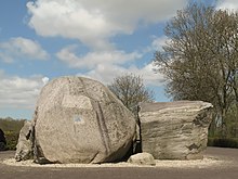
Visible from considerable distance across the relatively flat terrain of the prairie landscape, ‘Big Rock’ is an enormous glacial erratic. The 16,500-tonne (18,200-ton) boulder was originally part of a mountain formation in what is now Jasper National Park. During the last ice age – about 30,000 years ago – a large rockslide crashed debris onto the surface of a glacier that occupied the present day Athabasca River valley, and this debris, including Big Rock, was carried out of the mountains on the glacial surface between 10,000 to 30,000 years ago. As the ice melted and the glacier retreated to the mountains, the rocky debris, including this huge erratic, were deposited across the prairies. 
The Indigenous Blackfoot peoples name for the erratic is derived from their word for rock, which is “okatok.”
The Okotoks Erratic – made up of quartzite that is light grey, pink, to purplish in colour – measures about 9-metres tall, 41-metres long and 18-metres wide, or about the size of a three-storey apartment building.
It is a piece of the Gog Formation; layers of sediment deposited between 600 million and 520 million years ago in a shallow sea eons before the uplift of the Rocky Mountains. As time passed, the sediment was buried as layer upon layer built up four kilometres deep in places. The heat and pressure generated by the weight of the overlying sediments compacted the sand grains and cemented them into an extremely hard, durable rock called quartzite. Quartzite is slippery to climb and although it is hard, pieces can break off.

