
NEW BRUNSWICK
NB is one of four Atlantic provinces on the east coast of Canada. According to the Constitution of Canada, New Brunswick is the only bilingual province. About two-thirds of the population are anglophones, one-third francophones, and one-third bilingual. Atypically for Canada, only about half of the population lives in urban areas, mostly in Greater Moncton, Greater Saint John, and the capital, Fredericton.
Unlike the other Maritime provinces, New Brunswick’s terrain is mostly forested uplands, with much of the land further from the coast, giving it a harsher climate. New Brunswick is 83% forested and less densely populated than the rest of the Maritimes.
Being relatively close to Europe, New Brunswick was among the first places in North America to be explored and settled by Europeans. In 1784, after an influx of refugees from the American Revolutionary War, the province was founded on territory from the partition of Nova Scotia. In 1785, Saint John became the first incorporated city in Canada. The province prospered in the early 1800s, and the population grew rapidly, reaching about a quarter million by mid-century. In 1867, New Brunswick was one of four founding provinces of the Canadian Confederation, along with Nova Scotia and the Province of Canada (now Ontario and Quebec).
After Confederation, wooden shipbuilding and lumbering declined, while protectionism disrupted trade ties with New England. The mid-1900s found New Brunswick to be one of the poorest regions of Canada, now mitigated by Canadian transfer payments and improved support for rural areas. As of 2002, provincial gross domestic product was derived as follows: services (about half being government services and public administration) 43%; construction, manufacturing, and utilities 24%; real estate rental 12%; wholesale and retail 11%; agriculture, forestry, fishing, hunting, mining, oil and gas extraction 5%; transportation and warehousing 5%.
Tourism accounts for about 9% of the labour force directly or indirectly. Popular destinations include Fundy National Park and the Hopewell Rocks, Kouchibouguac National Park, and Roosevelt Campobello International Park. In 2013, 64 cruise ships called at Port of Saint John, carrying, on average, 2,600 passengers each.
FREDERICTON (pop 58,220)
Fredericton is the capital of New Brunswick. The city is situated in the west-central portion of the province along the Saint John River, which flows west to east as it bisects the city. It is the third-largest city in the province after Moncton and Saint John.
An important cultural, artistic, and educational centre for the province, Fredericton is home to two universities, the New Brunswick College of Craft and Design, and cultural institutions such as the Beaverbrook Art Gallery, the Fredericton Region Museum, and The Playhouse, a performing arts venue.
The city hosts the annual Harvest Jazz & Blues Festival, attracting regional and international jazz, blues, rock, and world artists.
As a provincial capital, its economy is tied to the public sector; however, the city also contains a growing IT and commercial sector. The city has the highest percentage of residents with post-secondary education in the province and the highest per capita income of any town in New Brunswick.
Boyce Farmers Market. Open only on Saturday from 6-1, this is a large enclosed market supplemented by many trucks parked outside. There
Loch Alva Wilderness Area covers 220 sq km, making it one of New Brunswick’s largest Protected Natural Areas. This pristine wilderness has limited access, so exploring the area is best done on foot or by boat. The 16.6km Loch Alva trail (Loch Alva is a drinking water reservoir for the city of Saint John) ascends 474m along a less-travelled ATV track that passes through several extensive wetlands as far as Brittain Stream, then follows the shoreline or bushwhacks your way.
SAINT JOHN (pop 67,000, metro 126,202)
A seaport city on the Bay of Fundy, Saint John is the oldest incorporated city in Canada, established in 1785. By tonnage, it is Canada’s third-largest port.
French colonist Samuel de Champlain landed at Saint John Harbour on June 24, 1604 (the feast of St. John the Baptist), where the Saint John River gets its name. However, Mi’kmaq and Maliseet peoples lived in the region for thousands of years prior, calling the river Wolastoq. The Saint John area was necessary for trade and defence for Acadia during the French colonial era. Fort La Tour was a pivotal battleground in the city’s harbour during the Acadian Civil War.
After over a century of ownership disputes over the land surrounding Saint John between the French and English, the English deported the French colonists in 1755 and constructed Fort Howe above the harbour in 1779. In 1785, thousands of refugees who wished to remain British arrived from the American Revolution and were forced to leave their U.S. homes. Over the next century, waves of immigration via Partridge Island, especially during the Great Famine, would fundamentally change the city’s demographics and culture.
Carleton Martello Tower. After the US declared war on Great Britain in 1812, this round stone tower was built to defend against a landward attack. Hundreds were built, and they were easy to defend and economical to build. They consisted of thick tapering walls, a central support pillar, and a second-story entrance. A concrete superstructure was added in WWII, but it was never attacked.
Fundy NP. Located on the Bay of Fundy, near the village of Alma, it showcases a rugged coastline which rises to the Canadian Highlands, the highest tides in the world and more than 25 waterfalls. The Park covers an area of 207 km2 (80 sq mi) along Goose Bay, the northwestern branch of the Bay of Fundy. When one looks across the Bay, one can see the northern Nova Scotia coast.
At low tide, explore the ocean floor with dog whelk, periwinkles and various seaweeds clinging to life. The ocean floor disappears under 15 m (50 ft)of salt water at high tide.
There are 25 hiking trails throughout the park. The Caribou Plains trail and boardwalk provide access to upland forest and bog habitats. Dickson Falls is the most popular trail.
Park amenities include a golf course, a heated saltwater swimming pool, three campgrounds, and over 100 km of hiking and biking trails. During the winter, it is used for cross-country skiing, snowshoeing, tobogganing, and winter walking. The Dobson Trail and Fundy Footpath extend out of the park to Riverview and to St. Martins respectively. A unique red-painted covered bridge is located at Point Wolfe.
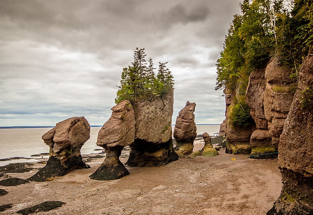
Hopewell Rocks. These 40-70- foot tall rock formations are on the upper reaches of the Bay of Fundy. Due to the extreme tidal range of the Bay of Fundy, the base of the formations are covered in water twice a day. It is possible to view the formations from ground level at low tide.
The formations consist of dark sedimentary conglomerate and sandstone rock. The waves have eroded the base of the rocks at a faster rate than the tops, resulting in their unusual shapes. Visitors are advised to stay for a complete tidal cycle to appreciate the tides and formations. Although the tides vary from day to day, the high tide can be as high as 16 metres (52 ft), giving the Hopewell Rocks one of the highest average tides in the world.
On March 14, 2016, Elephant Rock, part of one of the Hopewell Rocks, collapsed, and 100 to 200 tonnes of rock fell. From the vast parking lot and entrance, turn left to see Diamond and Flower Pot Rocks.
Demersailles Beach. From the visitor center, walk 600m in the other direction from the rocks.
I drove north to Moncton and then south to try to enter Nova Scotia. Despite having paperwork stating that I had just finished a two-week quarantine the day before in Fredericton, I could not enter NS without agreeing to another two-week quarantine. I was not willing to do that. I have applied for a travel exemption to Newfoundland, and I am now hoping to enter Labrador via Quebec, see Newfoundland, and cross back into NS to start my return journey home to British Columbia.
Canaan Bog. Flat-to-gently rolling terrain sweeps along the entire eastern side of the province, with elevations ranging from sea level to 190 metres. The climate is warm and the driest part of the province. The soil is poorly drained, and as a result, the site is extremely wet. Much of the land cover is bog, interspersed with a complex network of forested islands, covered mainly with black spruce, jack pine, intolerant hardwood, and eastern cedar.
Cape Jourimain Lighthouse, Bayfield. This white/red-capped LH sits on the last island for the Confederation Bridge to PEI. It can’t be accessed.
Parlee Beach, Pointe-du-Chêne. On a fabulous sunny day at the end of May, this beach was crowded with some even in the water. The parking lot was full. No one was wearing a mask or practicing any distancing.
Kouchibouguac NP. On the east coast of New Brunswick, the park includes barrier islands, dunes, lagoons, salt marshes and forests. It provides habitat for seabirds, including the endangered piping plover, and North America’s second-largest tern colony. Colonies of harbour and grey seals also inhabit the park’s 25 kilometres (16 mi) of dunes. It is also home to the extremely rare and fragile Gulf of St. Lawrence aster, though in 2006, storms eradicated most of the asters’ colonies. The park’s size is 238 km2 (92 sq mi).
Recreational activities in the park include swimming, cycling, hiking, river adventures in a voyageur-style canoe, seal watching, and talks about Mi’kmaq band governments. The park is also home to the popular Kelly’s Beach.
Mount Carleton Provincial Park. Established in 1970, it is the largest provincial park in New Brunswick at 174 square kilometres (67 sq mi) in the remote highlands of north-central New Brunswick.
The park’s dominant natural features include the highest peak in the Maritimes, Mount Carleton, and several large freshwater lakes (Nictau Lake, Little Nictau Lake, Bathurst Lake, and the Nepisiguit Lakes). Located at the headwaters of the Nepisiguit River and the Tobique River, the lakes offered a convenient portage route between the Nepisiguit and Saint John River watersheds. The Canadian portion of the International Appalachian Trail passes through the park.
The mountains in the park are erosional remnants of resistant igneous rocks that remained after an ancient Mesozoic peneplain surface was uplifted in the Cenozoic to form a plateau, and subsequently dissected via millions of years of erosion by wind, water and glacial ice.
Mount Carleton Provincial Park has 11 hiking trails and four prominent mountain peaks, each accessible by trail: Mount Carleton, 820m (2,690 ft); Mount Head, 792m (2,589 ft); Mount Sagamook, 777m (2,549 ft); and Mount Bailey, 564m (1,850 ft).
Newly renovated cabins along Nictau Lake and Bathurst Lake provide comfortable, rustic wilderness experiences for any outdoor enthusiast. The park has three camping areas and many family activities throughout the season.
An annual stargazing event usually takes place in late July or early August. Mount Carleton Provincial Park’s night sky is among the darkest in Canada.
Campbellton Range Rear Lighthouse, Campbellton. In 1985, the City of Campbellton incorporated the existing steel, skeletal tower into an octagonal lighthouse with an attached dwelling that operates as Campbellton Lighthouse Hostel, part of Hostelling International.
The first set of Campbellton Range Lights was built in 1879 by Peter Naduux of Dalhousie, who received a $762 contract to erect six small, square towers, twenty-two feet tall. Two towers displayed fixed white catoptric lights at Campbellton, two at Dalhousie, and two across the Restigouche River at Oak Point in Quebec. In 1895, the rear range tower was moved and raised fifteen feet.
In 1902, Campbellton had a population of 2,652 and functioned primarily as a lumber port, with over twenty-four million feet of lumber being shipped from its wharves that year. By 1917, the original rear tower was replaced by a light on a pole and a utilitarian square. A steel tower later replaced the square front tower, and Campbellton lost its final historic lighthouse. At least visitors to the city today can find clean, inexpensive accommodations in a modern lighthouse.
NOVA SCOTIA (Halifax, Lunenburg)
I arrived at the New Brunswick / Nova Scotia border on the morning of May 27, less than 24 hours after finishing a two-week quarantine at a federal government-administered facility (the Quality Inn in Fredericton), and I had a certificate verifying that. I could not enter NS without agreeing to another two-week quarantine, but I was not willing to do that, so I returned to travel in the Gaspe Peninsula and Quebec.
I have applied for a travel exemption to Newfoundland. I am now hoping to enter Labrador via Quebec, see Newfoundland, and cross back into NS to start my return journey home to British Columbia. But that is unlikely to happen.
NOMAD MANIA Nova Scotia (Halifax, Lunenburg)
World Heritage Sites
Joggins Fossil Cliffs
Landscape of Grand Pré
Old Town Lunenburg
Islands: Cape Breton Island
Borders: Canada, except Newfoundland (sea border/port)
XL
Long Island (Nova Scotia)
Sable island
St. Paul Island (Nova Scotia)
Museums:
Glace Bay: Miner’s Museum
Parrsboro: Fundy Geological Museum
Stellarton: Nova Scotia Museum of Industry
House Museums/Plantations
Springhill: Anne Murray Centre
Starr’s Point: Prescott House Museum
Windsor: Haliburton House Museum
Religious Temples: Cape Breton: Gampo Abbey
World of Nature: Cape Breton Highlands
Festivals
Halifax Pop Explosion
Nova Scotia Gaelic Mod
Zoos: Aylesford: Oaklawn Farm Zoo
Theme Parks: Annapolis Royal, Upper Clements Parks
Lighthouses
Antigonish: Arisaig Lighthouse
Louisburg: Louisbourg Lighthouse
Peggy’s Cove: Peggy’s Point Lighthouse
Sambro Island Light
Beaches: Ingonish Beach
Hospitality Legends
Annapolis Royal: Queen Ann Inn
Digby: Digby Pines Golf Resort & Spa
Open-Air Museums: Ross Farm Museum
Aviation Museums: Greenwood: Greenwood Military Aviation Museum
Cities of the Americas
HALIFAX World Cities and Popular Towns
Airports: Halifax (YHZ)
Museums:
Art Gallery of Nova Scotia
Canadian Museum of Immigration at Pier 21
Discovery Centre
Mary E Black Gallery
Nova Scotia Museum
Nova Scotia Sport Hall Of Fame
Castles, Palaces, Forts: Halifax Citadel (Sight Citadel Hill)
Modern Architecture Buildings: Halifax Central Library
Botanical Gardens: Halifax Public Gardens
Hospitality Legends
Lord Nelson Hotel
The Split Crow Pub
The Westin Nova Scotian Hotel
Markets: Seaport Farmers’ Market
Maritime/Ship Museums: Maritime Museum of the Atlantic / CSS Acadia / HMCS Sackville
Aviation Museums: Atlantic Canada Aviation Museum
Villages and Small Towns
MAHONE BAY
YARMOUTH
LUNENBURG
World Heritage Sites: Old Town Lunenburg
Museums: Fisheries Museum of the Atlantic
SYDNEY*
Airports: Sydney (YQY)
Museums: Old Sydney Society Museum
House Museums/Plantations: Cossit House Museum
