
Cape Verde (Portuguese: Cabo Verde) comprises a group of islands in the Atlantic Ocean, 500 km west of Senegal. Cape Verde is formed by 10 main islands and about 8 islets.
The once uninhabited islands were discovered and colonized by the Portuguese in the 15th century; they subsequently became a trading center for African slaves and later an important coaling and re-supply stop for whaling and transatlantic shipping. Independence was achieved in 1975.
Most Cape Verdeans have both African and Portuguese ancestors.
Capital: Praia
Currency: Cape Verdean escudo (CVE)
Population: 546,000
Country Code: +238
SEE

Proposed Itinerary
Day 1,2. Arrive Praia (RAI) from Azores. Rent car airport, see sights in Praia. Drive to Tarrafel. Overnight or drive along east coast back to Praia. Ferry to Fogo.
Day 3. Fogo: 6am start to climb Pico do Fogo. See Sao Felipe,
Day 4, 5. Fly Mindelo (MDX) on Sao Vicente. Ferry to Porto Novo, Sao Antao. Hitchhike or bus to Cova, walk through crater to Paul. Go to Ribeira Grande. Return Mindelo
Day 6. Ferry Sao Vicente, Santa Luzia
Day 7. Return Mindelo. Fly Madeira.
SOLAVENTO ISLANDS (São Tiago, Fogo – Praia)
SANTIAGO
The first island settled in Cape Verde. It holds the current capital Praia, the original capital Cidade Velha, and the bulk of the nation’s population.
PRAIA Capital. See the town hall, cathedral and Palace of Justice
Centre historique de Praia. Tentative WHS (15/03/2016)
Praia Airport (RAI)
Forte Real de São Felipe, Cidade Vehla
Archaeology Museum (Archivo Nacional de Cabo Verde)
Ethnography Museum Praia
Sala-Museu Amilcar Cabral. (Fundacao Amilcar Cabral) House Museum.
Pro-Cathedral of Our Lady of Grace (Igreja Nossa Senhora da Graca)
Farol de D. Maria Pia
Monumento ao emigrante. At the Praia International Airport
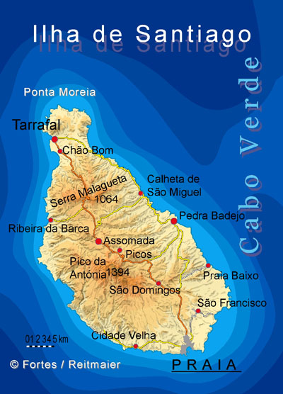
Camp de concentration du Tarrafal. Tentative WHS (15/03/2016). Tarrafal was a concentration camp located in the village of Chão Bom established in 1936, during a reorganization process of the Portuguese Estado Novo prison system, with the goal of incarcerating political and social prisoners. The location was strategically chosen for having an unhealthy climate, with little drinking water, and many mosquitoes in rainy seasons, which facilitated the appearance of diseases. Its main objective was to physically and psychologically annihilate Portuguese and African opponents of the Salazar dictatorship, isolating them from the rest of the world in subhuman conditions of captivity, mistreatment, and insalubrity.
Its first phase, from 1936 to 1954, was aimed at Portuguese opponents. On October 29, 1936, the first 157 antifascist detainees arrived from Lisbon, some of them participants in the Sailors’ Revolt of 1936. In the first two years, when the prisoners’ only housing was canvas tents, they were forced to work for 45 days in extremely high temperatures to build the camp wall and other infrastructure. When the first illnesses began to appear, the only doctor present had no medicine to treat the patients, so he limited himself to issuing death certificates. Of the 340 Portuguese anti-fascists who passed through the camp, 34 died. The “Frigideira”, also called “elimination chamber” or “torture chamber” by the prisoners, was a place of punishment where prisoners were tortured, being deprived of food, light, and under temperatures between 50 and 60 degrees. The “Frying Pan” was responsible for the death of 30 prisoners, and the sickness of dozens of others. The current museum of the resistance counts 2824 days spent by prisoners in the “Frigideira”.
In the second phase, which reopened the camp on April 14, 1961, it began to hold militants from the national liberation struggles of the Portuguese colonial war in Angola, Guinea-Bissau, and Cape Verde. 106 Angolans, 100 Guineans, and 20 Cape Verdeans went through Tarrafal. Replacing the “Frigideira”, the “Holandinha” was opened, with almost the same objective, being “a little taller than a man standing, a little longer than a man lying down, a little wider than a man sitting down, with a small barred window” and “a real oven”. One Angolan and two Guinean political prisoners died in this camp.
Following the Carnation Revolution in 1974, together with the end of the Estado Novo dictatorship, the camp was closed one week later. In 2009 it was transformed into the Museum of Resistance. In honor of the anti-fascist struggle and resistance in Cape Verde, October 29 was consecrated as “Antifascist Resistance Day”.
CVFastferry operates Santiago – Fogo – Brava
Current schedules and ticket purchase: https://www.cvinterilhas.cv.
FOGO. A spectacular volcano island which erupted as recently as 2014. Farmers are still growing vines for wine in the crater and growing coffee on its slopes.
SAO FILIPE – capital of island Fogo
Centre historique de São Filipe. Tentative WHS (15/03/2016)
Casa da Memoria. Museum
Our Lady of Conception church, São Filipe. (Paroquia Ns Conceicao)Parc Naturel de
Fogo – Chã das Caldeiras. Tentative WHS (15/03/2016)
Pico de Fogo. The highest peak of Cape Verde and West Africa, rising to 2,829 metres (9,281 ft) above sea level. It is an active stratovolcano – the main cone last erupted in 1680, causing mass emigration from the island. A subsidiary vent erupted in 1995. The only deadly eruption was in 1847 when earthquakes killed several people.
Fogo is a hotspot volcanic island. Its most recent eruptions occurred in 1951, 1995 and 2014. It is the youngest and most active volcano in the Cape Verde Islands, a short chain of volcanic islands that generally are younger at the western end, formed as the African Plate moved towards the east over the hotspot.
Fogo consists of a single volcano, so the island is nearly round and about 25 kilometers (16 mi) in diameter. The large summit caldera (about 10 kilometers in the north–south direction and 7 kilometers in the east–west direction) is not located in the center of the island, but rather towards its northeastern corner. The caldera is bounded by steep near-vertical fault scarps on the north, west, and south sides but is breached to the east where lava can flow to the coast.
The mountain’s slopes are used to grow coffee, while its lava is used as building material. Near its peak is a caldera and a small village, Chã das Caldeiras, is inside this caldera and an hour’s drive from Sao Felipe. The crater rim, which reaches 2,700 m elevation, is known as Bordeira. From town, follow the dirt road through lava flows, ash fields and small dry riverbeds, until you get to a ridge, the start of the climb. Here you can see people slowly making their way up the zig-zag path towards a big wall. The scramble to the ultimate top is aided by iron cables (a bit like a Via Ferrata) for a breath-taking panoramic views of the Pico de Fogo crater and Chã das Caldeiras.
A guide is not really necessary (the regular route up is from the north of the volcano from a track leading eastwards out of Portela – follow the other hikers with guides). They tend to start very early, usually at the crack of dawn. Be aware of false tracks made by the guides! Normally the ascent runs through rocky ground and not through loose gravel.
The volcano’s cone remains intact and can be climbed. You need a good pair of boots as the slopes are covered in slippery cinders. The taxing ascent takes 3-4 hours, and the view from the top is magnificent. Afterwards, it’s a gentle trot to get back down.
MAIO
BRAVA. A small, very hilly island accessible by ferry from Fogo a few times a week and is a great place to get away from it all. Faja de Agua is a dramatic remote bay and village from which the American Whaling ships collected supplies and crew with many from Brava now settled in Boston, USA. A botanist’s paradise, home to many unique flora that live in its misty forests
Centre historique de Nova Sintra. Tentative WHS (15/03/2016)
BARLAVENTO ISLANDS (Sal, Boa Vista, São Vicente)
SÃO VICENTE
MINDELO. Port city, probably the country’s liveliest, the cultural capital.
Mindelo Airport (VXE)
Casa Cesaria Evora. House Museums/Plantations.
Our Lady of Light Cathedral (Igreja da Nossa Senhora da Luz
Mercado Municipal.
Farol de D. Luis, Ilhéu dos Pássaros. Lighthouse
“Inter Ilhas” ferry travels every day between São Vicente and Santo Antão – 50 minutes, arrive 25 minutes before departure (the ferry is very punctual and removes the stairs 10 minutes before departure). Tickets: 800 Escudos in Mindelo at “Cais Marítima” 6.00 a.m. – 12.00 a.m. and 3.00 p.m. – 7.00 p.m. Ticket sales in Porto Novo at Harbour entry. Buy tickets online: https://www.cvinterilhas.cv
Mindelo – Porto Novo:Mon-Sat at 7.00 a.m. Mon-Sun at 4.00 p.m. *
Porto Novo – Mindelo:Mon-Sat at 9.00 a.m. Mon-Sun at 6.00 p.m. *
* Every two weeks it travels to São Nicolau on Thursday afternoon, so no ferry to and from Santo Antão.
SANTO ANTÃO
Great hiking. Canyoning. No airport.
PORTO NOVO (pop 9,310). There are 4 daily ferry connections from Mindelo on São Vicente island to Porto Novo.
Woman Waving, Monument to Migration, Porto Novo. Near the ferry terminal

Parc Naturel Cova, Paúl et Ribeira da Torre. Tentative WHS (15/03/2016). On the northeast corner of the island of Santo Antão, between 400m in the Xoxô area and Pico da Cruz at 1585m. The highest areas (above 1000m) contain a volcanic crater (Cova), forest areas of Pinus, Eucalyptus and Grevillea, steep peaks, and cliffs that end in deep valleys overlooking the sea (Ribeira da Torre and Paúl). Sample of the humid mountain ecosystems and agricultural ecosystems of Cabo Verde. At the end of the 16th century Ribeira Grande became the first settlement of the island of Santo Antão. 350 families practiced traditional agriculture. Goats produce traditional goat cheese.
Steep mountains and steep cliffs force man to adapt with ingenuity with the network of local roads and paths, soil conservation and protection systems, and drainage and irrigation infrastructure.
Small houses built in masonry with basalt stones and clay, with a door and two windows. The sugar cane straw roof is placed on a structure made from rush canes tied with a sisal rope. Terraces promote soil conservation and protection against water erosion. Simply constructed of basalt stones with unique geometric shapes imposed by the slope of the land. Traditional water intake and reservoirs allow rain-fed agriculture subject to gravity irrigation. The areas of Chã Mato and Corda are mainly occupied by rainfed crops maize, peas, sweet potatoes, pumpkin, potato as well as fruit trees: apple, quince, guava and vines). The same type of agriculture extends to the crater of Cova, with the particularity of allowing two annual harvests, one in the rainy season and another at the beginning of the hot season with the rise of humidity by evaporation.
The predominant irrigated agriculture in the valleys of Paúl and Ribeira da Torre, mainly produces sugar cane, coffee, yams, bananas, papaya, mango, among others.
The famous grogue (brandy) of Santo Antão dates back several centuries uses sugar cane and is produced in the traditional way, using a mill and animals to obtain the syrup. Molasses or honey is made in large pots made of stone and cement. In the municipality of Paúl, one of these centuries-old traditional pots can be visited.
Network of local roads and paths in addition to the traditional Ribeira Grande-Porto Novo route. Built in the first decade of the sixties of the twentieth century, this road is still used daily by the local community. These paths opened up inaccessible places in the deep valleys surrounded by steep mountains.
Handicrafts using raw local materials (sisal, reed), processing of agricultural products: grogue, cheese. of goat cheese, liqueurs and jams, traditional tales, working songs, traditional medicine based on endemic and medicinal herbs.
The Cova crater is a natural geological formation, covered by phonolitic lava and tephra dating from the Pliocene and Pleistocene, and composed of two types of soils: androssolos and leptossolos. The Cova crater also functions, from a hydrographic point of view, as a recharge basin for the sources of Ribeira da Torre and Paúl.
The northeast coast of Cova crater is connected with Paúl Ribeira through a vast lava tunnel.
Cova valley – located in the crater of the extinct volcano.
Hike from top of Cova Crater 11kms and 1300m elevation change to Pombas. Take a taxi up and walk down.
The national road EN1-SA01 connects Porto Novo with Ribeira Grande, passing through the mountainous interior. The EN1-SA03 leads to Pombas along the east coast. The EN1-SA04 leads west to Ponte Sul. Since the closing of Agostinho Neto Airport, located in Ponta do Sol, there is no functioning airport on the island.
RIBEIRA GRANDE
Cidade Velha, Historic Centre of Ribeira Grande. World Heritage Site. “Old City”.
The town of Ribeira Grande, renamed Cidade Velha in the late 18th century, was the first European colonial outpost in the tropics. Located in the south of the island of Santiago, the town features some of the original street layout and impressive remains including two churches, a royal fortress and Pillory Square with its ornate 16th century marble pillar.

It marks a decisive step in European expansion at the end of the 15th century towards Africa and the Atlantic area. Ribeira Grande was subsequently, in the 16th and 17th centuries, a key port of call for Portuguese colonisation and its administration. It was an exceptional centre in the routes for international maritime trade, included in the routes between Africa and the Cape, Brazil and the Caribbean. Its insular position, isolated but close to the coasts of Africa, made it an essential platform for the Atlantic trade of enslaved persons of modern times. A place of concentration of enslaved persons and the inhuman practices of the trade of enslaved persons, Ribeira Grande was the first developed Creole society. New forms of colonial agriculture on the boundary between the temperate and tropical climates and it became a platform for the acclimatisation and dissemination of plant species across the world.
Creole culture spread across the Atlantic, adapting to the different colonial contexts of the Caribbean and Americas. Its forms affected many fields including the arts, social customs, beliefs, the pharmacopoeia, and cooking techniques.
SANTA LUZIA Santa Luzia is uninhabited but can be visited as a day trip from São Vicente. Area 34.27 km2, smallest, rugged central mountain range crowned by Mount Topona (397 m). Composed of beaches, mobile dunes, river bottoms and wide flow beds, lava formations, sediment deposition surfaces, basaltic platforms, superficial limestone slabs, hills as well as mountain ranges (ridges, summits, valleys and steep sculpted slopes).
Monte da Ribeira do Ladrão (165 m).
Important for the nesting and reproduction of the Bossa whale and the common turtle. Also endemic reptiles and birds that are endangered.
Complexe d’aires Protégées de l’île de Santa Luzia et des Ilots Branco et Raso. Tentative WHS: (15/03/2016). Complex of Protected Areas of Santa Luzia Island and Branco and Raso Islets. The Santa Luzia Natural Reserve and the Integral Reserve of the Branco and Raso islets. These islands, discovered in 1461 by the Portuguese, have always been uninhabited (Santa Luzia was inhabited in the 19th and the first half of the 20th century. Subsequent attempts to settle the island were unsuccessful).
In the northwest of the archipelago, 8 km from Sao Vicente and 16 km from São Nicolau. Total area 609.6 km2 – land, marine and buffer zone.
Santa Luzia Nature Reserve
Ilheu Branco. XL Branco islet: area 2.78Km2. White sand dunes reach up to 100m. Visible part of a large volcano Mount Berta (353 m).
Ilheu Raso. XL Raso islet: area 5.76 km2. Has a steep coast due to basaltic lavas, flat with some peaks
SAL. Has great beaches, water sports and resorts aplenty, but little else.
Espargos is the capital of Sal where the airport is.
Santa Maria– former administrative capital and the most populous city on Sal, main tourist area at the south of the island
Salines de Pedra de Lume. Tentative WHS: (15/03/2016). Pedra de Lume is in northeast Sal, 5 km east of Espargos. It has a small port and a lighthouse.
Pedra de Lume has been famous for its salt evaporation ponds (salinas), dating from the 18th century. The waters in the lake rise from deep in the earth and are situated in the crater of an extinct volcano.
Sal Airport (SID)
Viveiro Botanic Garden
Sal Beaches
Olho Azul, Buracona – Sal. Cave
SANTA MARIA
Paróquia de Nossa Senhora das Dores
Farol da Ponta do Sinó
Santa Maria Beach
BOA VISTA. The best beaches.
Boa Vista Airport (BVC)
Chaves Beach
Santa Monica Beach
SÃO NICOLAU
+++++++++++++++++++++++++++++++++++++++++++++++++
Climate. Temperate, with a warm, dry summer. Precipitation meagre in June to February, peaking in September. Sal, Boavista and Maio see almost no rain. Santiago, Fogo and Santo Antao have the most.
Language. Portuguese but the local language is Cape Verdean Creole – 90-95% from Portuguese and the rest West African languages. Young urban people speak English.
GET IN
Visa. Most African countries don’t need a visa. Everybody else may obtain a visa on arrival for 30 Euros.
By plane. Many flights Europe, Boston, Washington DC, and Fortaleza (Brazil).
From Africa. TACV Cabo Verde Airlines.
Best: TAP from Lisbon. Azores Airlines from Ponta Delgada, Azores.
Connect via Lisbon with Madeira (cheapest), also direct for almost 2x cost.
GET AROUND
Timetables often not followed.
By plane. TACV Cabo Verde airlines has regular flights between the majority of the islands. Domestic tickets are cheaper if purchased in Cape Verde.
If your international flights are booked with TACV, you can purchase a Cabo Verde Air Pass for flights within 21-day period. Price start at €110 for two coupons and €60 for every extra coupon. TACV flights can be rebooked for 2,000$ (escudos).
By boat. There are ferry services between the islands. Flying significantly shorter but also significantly more expensive.
By taxi. Aluguers, open-back pickup trucks with bench seats or 15-passenger Toyota vans, travel between rural destinations, particularly on Santo Antão.
Money. Escudo, “![]()
![]() ” (a cifrão, a symbol similar to the dollar sign, but with two vertical strokes instead of one) after the amount. (CVE). The currency is fixed against the euro at 110$ per euro.
” (a cifrão, a symbol similar to the dollar sign, but with two vertical strokes instead of one) after the amount. (CVE). The currency is fixed against the euro at 110$ per euro.
Costs. Since most goods are imported, the costs are moderate to high.
Food. Fresh seafood. Tuna and Wahoo, lobster.
Sleep. Many hotels and guest houses.
Stay Safe. Crime rates are relatively low.
Health. In the resorts, the tap water is usually desalinated and safe to drink. In other areas, bottled water is cheap and commonly available.
Respect. People are polite and friendly: they will try to sell you something and if you refuse, they will invent stories about the hardship of their families. It is good to buy something, but important to bargain.
Connect. Mobile phone coverage in all cities and most towns.
++++++++++++++++++++++++++++++++++++++++++++++++++++++++++++++NOMAD MANIA Cabo Verde – Barlavento Islands (Sal, Boa Vista, São Vicente)
Experiences
Tabanka. Is a musical genre of Cape Verdean music. In its traditional form, a singer mainly chants a verse that are repeated in unison by other singers. It is rhythmically done with drums and other instruments including whistlers and conches. Rhythmically there are four variants of tabanca.
Along with funaná and batuque, tabanka was a symbol for the struggle for Cape Verdean independence.
Taste cachupa. is a famous dish from the Cape Verde – a slow cooked stew of corn (hominy), beans, cassava, sweet potato, fish or meat (sausage, beef, goat or chicken), and often morcela (blood sausage). Referred to as the country’s national dish, each island has its own regional variation. The version of the recipe called cachupa rica tends to have more ingredients than the simpler, cachupa pobre.
Islands
SÃO NICOLAU
SANTO ANTÃO
RIBEIRA GRANDE Villages and Small Towns
World Heritage Sites: Cidade Velha, Historic Centre of Ribeira Grande
Tentative WHS: Parc Naturel Cova, Paúl et Ribeira da Torre (15/03/2016)
World of Nature: Cova-Ribeira da Torre-Paul Natural Park
Monuments: Porto Novo: Woman Waving, Monument to Migration
SÃO VICENTE
Lighthouses: Ilhéu dos Pássaros: Farol de D. Luis
MINDEO African Cities
Airports: Mindelo (VXE)
House Museums/Plantations: Casa Cesaria Evora
Religious Temples: Our Lady of Light Cathedral
Markets: Mercado Municipal
SANTA LUZIA
Tentative WHS: Complexe d’aires Protégées de l’île de Santa Luzia et des Ilots Branco et Raso (15/03/2016)
World of Nature: Santa Luzia Nature Reserve
XL: Ilheu Branco and Ilheu Raso
SAL
Tentative WHS: Salines de Pedra de Lume (15/03/2016)
Airports: Sal (SID)
Botanical Gardens: Viveiro Botanic Garden
Beaches: Sal Beaches
Caves: Buracona – Sal: Olho Azul
SANTA MARIA
Religious Temples: Paróquia de Nossa Senhora das Dores
Lighthouses: Farol da Ponta do Sinó
Beaches: Santa Maria Beach
BOA VISTA
Airports: Boa Vista (BVC)
Beaches
Chaves Beach
Santa Monica Beach
++++++++++++++++++
NOMAD MANIA Cabo Verde – Solavento Islands (São Tiago, Fogo – Praia)
Borders: Cabo Verde (sea border/port)
Islands
MAIO
BRAVA
Tentative WHS: Centre historique de Nova Sintra (15/03/2016)
SANTIAGO
Tentative WHS: Camp de concentration du Tarrafal (15/03/2016)
The Dark Side: Tarrafal prison camp
Castles, Palaces, Forts: Cidade Vehla: Forte Real de São Felipe
African Cities
PRAIA World Capitals World Cities and Popular Towns
Tentative WHS: Centre historique de Praia (15/03/2016)
Airports: Praia (RAI)
Museums
Archaeology Museum
Ethnography Museum Praia
House Museums/Plantations: Sala-Museu Amilcar Cabral
Religious Temples: Pro-Cathedral of Our Lady of Grace
Lighthouses: Farol de D. Maria Pia
Monuments: Monumento ao emigrante
FOGO
Tentative WHS: Parc Naturel de Fogo – Chã das Caldeiras (15/03/2016)
Tentative WHS: Centre historique de São Filipe (15/03/2016)
Borders: Cabo Verde (sea border/port)
Museums: Fogo: Casa da Memoria
Religious Temples: São Filipe: Our Lady of Conception church
World of Nature: Fogo
