
Latvia – Kurzeme and Zemgale (Jelgava, Ventspils, Liepāja) August 6, 2019
I went to this western region of Latvia bordering the Baltic Sea on August 6-7, arriving from the Riga region.
TALSI
Firck Palace (Latvian: Firksa muižas pils; German: Virckshof) is a palace in Talsi in the historical region of Courland, in western Latvia. It was built for Baron von Firck in 1883. The building currently houses the Talsi Regional Museum.
The museum had a very good photography exhibit of evocative nudes, sculptures by Vlnis Titans, pottery, wood crafts, a small ethnographic exhibit, Cuonian archaeology and upstairs: stuffed critters and a woodworking shop.
The palace is small and nice with wood doors and a parquet floor. €1.50, no reduction
Dundaga Castle, Dundaga. Originally built in the 13th century, it was reconstructed and added onto many times. It is now a venue for celebrations, weddings and accommodation. Seen by guided tour only €3.50, available in English.
Enter through the gate into the courtyard. The castle is surrounded by 3-story buildings on about 80% of the circumference. Go around to the north side for the tour – art, history and a lot of nice wood.
Cape Kolka. The cape has always been dangerous for navigation because of its sehlf stretching 6km out into the sea. The largest ship graveyard in the Baltic is here.
In the 13th century, watch fires were lit to find the turning point between the Irbe Strait and the Gulf o Riga. The first wood lighthouse dates to 1532 and wer replaced by square stone ones in 1787. In 1858, the dangerous Kolka shelf was marked by a lightship. The present lighthouse was built using boulders brought from Kurzeme and Estonia by boats or sledge on ice in winter. 14 rapeseed oil lamps and metal reflectors provide the light. The present light is 20m above the sea and can be seen for 10 nautical miles.
This is probably not worth the drive. Pay €3 to park a 3-4 minute walk from the cape (free a few hundred yards back along the road). Walk through pine trees and then a short boardwalk to the flat sandy triangle at the end with a few rocks on the tip. The most interesting is the 2 lights seen in the distance.
VENTSPILS (pop 40,000)
In the Courland area of Latvia on the Baltic and the Venta River, it is the 6th largest city in Latvia and has an ice-free port. It holds the record for the highest temperature ever recorded in Latvia of 37.8 in August 2014.
History. It developed around the Livonian Order Castle and was chartered in 1314. It became an important Hanseatic League city, a shipbuilding center and from here sailed the Duke’s fleet to colonize Gambia and Tobago. During both the Polish-Swedish War and the Great Northern War, it was destroyed and a plaque in 1711 wiped out most of the remaining citizens. After 1795, the Russians controlled it.
After about 1850, shipbuilding became important again, the port was modernized in 1890 and it was connected by rail to Moscow, becoming a very profitable port and increase in population in 1913 to 29,000.
In 1939, it became Soviet and an oil pipeline was built to here to become the USSR’s leasing crude oil port.
Population: 56% Latvian, 27% Russian, 4.5 % Ukrainian, 4.2% Belarusian. The port is a major employer and presents an ugly skyline across the river from the town. Stockholm is 350kms, Riga 125kms. It is opposite Gotland.
Ventspils has made a strong effort to attract tourism. Besides the port, it is quite attractive: every street, sidewalk and bicycle path is brick, using different colours for crosswalks and to separate walking/bicycle paths. There are a lot of cow statues, many quite humorous.
St. Nicholas Orthodox Church. This is a wonderful small Orthodox church. The spire has a steep blue roof with geometric designs and the apse is covered by 4 gilt domes all topped with brass orthodox crosses. Inside are 22 wood icon stands all festooned with brass plaques and columns and no less than 22 brass candle holders with 4 silver ones thrown in for good measure. The iconostasis is dark wood.
Castle of the Livonian Order. This relatively modern yellow/white trim manor house is surrounded by a white stone wall. Inside is the history of Ventspils and the areas.
Seaside Open-air Museum. This is primarily small boats under open-sided sheds, several anchors and maritime paraphernalia and 3 log houses with shingled roofs. €1.60, .60 reduced
Ventspils Beach. Cross a park, pass a beach volleyball stadium and walk on lovely boardwalk through the big dune area (covered in sea grass, bushes and trees) to reach this mammoth beach of fine white sand. It is very deep and long, stretching from the breakwater at the mouth of the river in the north for several kilometers south. It has playground equipment against the dunes. The water, like all Baltic beaches is quite shallow.
I slept on the street in a location with great wifi and got caught up on several things including business at home that had been waiting weeks.
The drive south to Kulgiga was full of road construction. The old road bed is being dug down by over a meter and being replaced with fill. They are doing short stretches at a time over 20kms creating huge traffic as the red light is long and the green short. It is difficult to comprehend the money being spent here. I passed many cars stopping at the red light prematurely and each time made it through before the red on the other side had changed. I probably saved 30 minutes of driving and a lot of frustration.
Ēdole Castle, Ēdole. This was only reachable on gravel roads so I elected not to go.
KULGIGA
Kuldīga Old Town in the Primeval Valley of the River Venta. A tentative WHS (18/04/2011), A Livonian Order Castle was built on the hill below the rapids in 1242-44, suffered greatly in the wars in the 17th and 18th centuries and was slowly removed by the local residents using the dolomite for building materials.
King John established a manufacturing industry with 70 businesses including a large shipbuilding industry. His 135 merchant ship line established colonies in the Gambia and Tobago.
I walked through the old castle gardens and over to the grand dark red brick church with its tall tower and steep green spire (closed), then circled back through the old town. It has a very decrepit appearance – shipped plaster, almost everything in need of paint.
Alekšupīte waterfall. This is an unusual waterfall as a dam has been constructed above the fall, the water moves through two gates and then appears to have a natural component. The small bridge directly over the falls has been closed. The waterfall looks very unnatural. It flows for about 100m before emptying into the Venta River. Just upstream is a lovely brick bridge with six very nice stone piers and brick vaulted arches between the piers. It was built in 1874 and is 164m long, one of the longest clay brick bridges in the world. In 1915 in WW I, the Russian army destroyed two spans of the bridge and they were restored in 1926, when several improvements were also made.
Venta Rapid. Possibly 200m above the bridge is this 2m waterfall that spans the entire width of the river for 249m, the widest natural waterfall in Europe. Salmon apparently jump the falls and there was an active salmon fishery here. 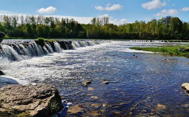
Museum of the Kuldiga Region. 1st floor – a model of the old town; 2nd floor – the living quarters of the house furnished as in the early 1900s, 3rd floor – a local art competition and some archaeology. Free
SKRUNDA
Skrunda-1. This is a ghost town and former Soviet radar station located 5 km (3 mi) to the north of Skrunda. It was the site of two Dnepr radar (NATO “Hen House”) radar installations constructed in the 1960s. A Daryal radar was being built there before the collapse of the Soviet Union. Skrunda was strategically important to the Soviet Union as its radars covered Western Europe. The two barn-like radars were one of the most important Soviet early warning radar stations for listening to objects in space and for tracking possible incoming ICBMs.
Pursuant to an agreement signed by Latvia and the Russian Federation in 1994, the Russian Federation had been allowed to run the radar station for four years, after which it was obliged to dismantle the station within eighteen months. The deadline for dismantling was 29 February 2000. Russia asked Latvia to extend the lease on the Dnepr station at Skrunda for at least two years, until the new Volga station under construction near Baranovichi in Belarus became operational. Riga rejected these requests, and the radar was verified closed on 4 September 1998.
On May 5th 1995 American demolition experts blew up a 19-storey tower in Skrunda-1. It housed a former Soviet Daryal radar system, one of the most advanced bistatic early-warning radars in the world. It served as one of the USSR’s most important radar stations as it was responsible for scanning skies to the west for incoming bombers or nuclear missiles before the USSR disintegrated. The event spilled tens of thousands of Latvian people onto country roads and fields to watch the early morning spectacle, which was also televised nationwide. Latvian leaders, diplomats and other officials toasted the blast with champagne. The demolition was sponsored by the United States, the Soviet Union’s main nuclear rival, as they paid 7 million US dollars for the destruction, while the US-based firm Controlled Demolition, Inc. was hired for the destruction job.
All materials of value were removed from the site and carried back to Russia when the last Russian troops left in 1998; the 60 buildings that comprised the former complex and town, including apartment blocks, a school, barracks and an officers club, remained. The dilapidated buildings were still standing in 2010.
The Latvian government decided to sell the Skrunda-1 site in 2008, and on 5 February 2010, the entire 40-hectare (99-acre) former town was sold as a single lot at auction in Riga. The starting bid was 290,000 USD and the winning bid was by Russian firm Alekseevskoye-Serviss for 2.2 million EUR. The winning bidder pulled out of the auction, as did the runner up. The town was reauctioned in June 2010 for only 170,000 Lats. In 2015 the site was bought by Skrunda Municipality for €12,000. Around half the area has been handed over to the Latvian National Armed Forces as a training ground. The remainder is to be leased by the local government with the stipulation that potential investors develop the area economically. Demolition of selected derelict buildings has since commenced. From February 2016 in response to increased interest at the site, the municipality began charging an entrance fee of 4 euros for individuals. Skrunda 1 was closed for visitors in 2018.
In the NM “Bizzarum” series, it is not possible to enter this property, at least legally. The road is crossed by razor wire and immediately after is a metal bar with a STOP sign and then a sign that basically says that this is military property of the Department of Defense and that any entry is prohibited including flying drones.
From the road, the main complex consists of at least five 5-story apartment buildings with about 20 windows per story. There are also a bunch of grey derelict concrete buildings and a water tower. It is about 8kms NE of the village of Skrunda off the highway on a potholed road for 1.5kms.
Rudbārži Palace. This palace was originally built in 1835 for Baroness Thea von Firck and was remodeled in 1882-1883. The structure was severely damaged by fire set by revolutionaries in 1905 but rebuilding began in 1908. During the Latvian independence struggle of 1919 Rudbārži Palace was a base for the Oskars Kalpaks Battalion (the 1st Latvian Independent Battalion). In 1937 a rest home for Latvian soldiers was established there. Following further destruction in 1938 there was a second reconstruction. During World War Two the palace served as a German field hospital, and was further damaged, and after the War it was used as a school for forestry workers.
From 1962 until 2017 the palace housed the Oskars Kalpaks Elementary School. The domed oval hall has been restored at great expense and renamed the “Heroes’ Hall”. The school closed owing to lack of pupils in 2017 and the house became a military centre for the New Guard.
This 2-story manor house is yellow with white trim and in need of a paint job. It is locked with no signs. I peered through the windows and it looks used with furniture visible. The grounds are nicely maintained with many flowers.
Grobiņa archaeological ensemble (Curonian Viking Settlement). A tentative WHS:This represents the first expansion of Scandinavians to the east across the Baltic Sea, most from Gotland and central Sweden. It was not very successful due to the local Baltic tribe, the Curonians, and they subsequently made their main expansion westward. Later they would return and establish large settlements well into Russia. The settlement here was called Sleeburg.
There are six parts to the archaeological ensemble:
Grobina Medieval Castle.
Grobina Hill Fort (Skabrza Hill)
Priedens Burial mounds. Dating to the 7th to 9th centuries AD, there are four mounds and flat graves with cremated remains and grave goods in the same manner as Scandinavia at that time, but also adopting practices from the local community as Baltic artefacts included in the Viking graves. The mounds are next to the monuments of the Curonians indicating that the two groups interacted. As the longevity of the burial mounds extended over 2 centuries, it is inferred that it was not a single military campaign but a series of smaller migrations in search of agricultural land. Curonian remained in the region as Iron Age burials continued.
Atkalne flat grave burial site. Smerhem flat grave burial site. Porani burial mound site.
All are connected by the Alande River by a 3km foot trail. Fre
KAROSTA
St. Nicholas Naval Cathedral. This is a wonderful cathedral of ornate cream brick work, mosaics and several gilt domes. Inside it is one large square room with many framed icons, Corinthian capitals and a large mural in the apse. I was kicked out for wearing shorts. Free
Karosta Prison. Karosta is a neighbourhood in the north of Liepāja by the Baltic sea.
Karosta was constructed in 1890-1906 as a naval base for the Russian Tsar Alexander III, and later served as a base for the Soviet Baltic Fleet. Now it is a very popular place for tourists and artists, since there are unique sights and interesting places, such as the scenic seascapes with partially blasted fortresses on the Baltic shore.
The base is of tactical importance due to its central location in the Baltic Sea and the fact that it does not ice over in winter. Built on the bare coast it consists of a large man-made harbour including a large breakwater and inland submarine warren. The army headquarters include czar-era mansions used by admirals, a palace for the czar (reportedly only used once), an impressive Russian Orthodox Naval Cathedral, as well as underground bunkers and abandoned storehouses. Soviet-era buildings include many rows of block housing. At its height Karosta was home to over 20,000 people.
When the Soviet Union army left Latvia in 1994 after Latvian independence, Karosta became largely uninhabited and most structures fell to ruin. In late 1990s, the area was troubled by high unemployment, street crime and drug problems.
In the NM “Dark Side” series, the Russians built a port at Karosta in the early 1900s and this brick building was originally to be a hospital, but instead was turned into a re-education facility. It remained that after Latvian independence in 1918, when the Soviets took over in 1939, when the Germans took control in 1941 and was only used as a prison for partisans and others by them in 1944. After 1945, it became a prison for Latvian dissenters. Seen only by guided tour in English or Russian.€5, 3.5 reduced
It is possible to spend the night in the guardhouse processed as a prisoner would have been, one of the more unique hotels in the world.
LIEPAJA
Skede Holocaust memorial. This is the site of massacres perpetrated by the Nazis during the Holocaust in WWII. It may not have been the worst of these atrocities in terms of scale, but it stands out as an especially evil event because it was so well documented – they took photos, even making the victims pose for the camera before their execution!
If you’ve ever seen any of those chilling photos of Jewish women huddled together, naked or scantily dressed, looking straight into the camera with pure terror in their eyes, or lined up with their backs towards the camera on the edge of an already corpse-filled trench, then chances are that they were taken here at Skede.
These photos are so infamous that they regularly feature in museums/exhibitions about the Holocaust in all manner of contexts, related or unrelated to the actual massacres of Liepaja. They are unique documents relating to this site, not only stills were taken, even moving images. That the material ever emerged was pure fluke. A forced labourer found the film rolls by chance while doing work in a German house and managed to make secret print copies before returning the original films. The copies themselves he buried in a safe place. They thus survived the war and were later used in tribunals as evidence before they became such high-profile documents in Holocaust exhibitions around the world.
The main massacres in the dunes of Skede took place from the 15th to the 17th of December 1941. They were the culmination of a long series of mass murder that had begun in June and took place in various locations, many of them quite public. The Liepaja massacres are often adduced as examples of such crimes being openly witnessed. Apparently there were even “execution tourists” amongst the German Wehrmacht, Navy and others, who travelled to the site to witness the mass shootings as “spectators”.
The December massacres at Skede had a death toll of ca. 2800 – out of a total of ca. 6500 murdered in Liepaja during the killing sprees by the Einsatzgruppen. Numbers of victims given earlier used to be much higher – as was so often the case, initial estimates had been exaggerated.
Nevertheless, it meant that virtually all of Liepaja’s Jews had been killed (of those who hadn’t managed to flee beforehand). A ghetto set up in Liepaja in 1942 had only a few hundred remaining residents. And these were sent on to Riga in 1943 and the Liepaja ghetto was closed. Thus the “extermination” of Jews was practically complete in Liepaja.
It wasn’t just Jews who were massacred here, however. There were also sizeable numbers of gypsies amongst the victims, as well as (suspected) communists, resistance fighters and others usually targeted by the Nazis.
Nor were the perpetrators all German. Latvians participated as well who not only acted as guards but also took an active part in some of the shootings. The local population, however, who could not help but know about all these atrocities, was much less enthusiastic and much discontent with the murders has been documented
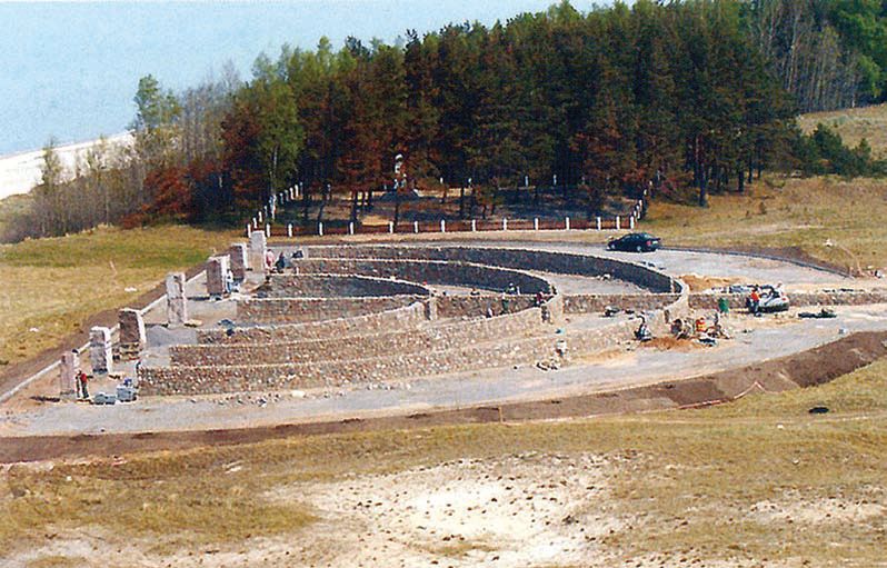
After the war, when Latvia yet again became part of the Soviet Union, only a typical small memorial was set up at the site, and as usual it made no particular reference to Jews. It wasn’t until long after Latvia’s regaining of independence in 1991 that the large monument that dominates the site today was inaugurated in 2005.
The new monument is quite gigantic in terms of area size. Seen from the air it has the shape of a giant menorah. But since it is lying flat, horizontally, on its side, it is much more difficult to see this from the ground. By the entrance to the complex, however, an information panel provides some details. It explains the design of the monument as well as a bit of the historical background. It’s slightly exaggerated in claiming that the entire pre-war Jewish community of Liepaja was murdered here, but it also provides some of the most iconic photos of the atrocities. The explanatory texts are in Latvian, Russian and English.
To the right of the approach track you pass a trio of black marble slabs with the inscription plainly and overtly dedicates the plaque to all the victims murdered here in the dunes of Skede. It gives the figures as “3640 Jews, including 1048 children” plus some 2000 Soviet prisoners of war and ca. 1000 Latvian civilians. This presumably includes those killed at the same site after the December 1941 mass shootings. This additional plaque was a reaction to the fact that the large main memorial failed to mention any of the non-Jewish victims.
You then approach the large memorial, from the bottom, as it were, i.e. you first get to what would be the foot of the menorah’s stand. This is flanked by two triangular, sloping marble plaques. The inscriptions on these are partly religious Torah quotes and lists of names, plus a Star of David. At the “top” of the memorial the ends of each menorah arm bear yet more plaques with Torah quotes. Set apart from the menorah arms stand tall granite columns in lieu of the menorah’s flames. The arms themselves are made of stone walls. The whole thing is so huge you can hardly take it all in – and you need a very wide angle lens to capture it in a single photograph.
To the north, just beyond the big new monument is a small grove of trees, and here you can find the old Soviet-era marker (dating from the 1960s). It is the typical obelisk shape made from white marble on a black marble base and a stone plinth. The bottom of the obelisk has two plaques on it, one in Latvian, the other in Russian. On these it is claimed that some 19,000 victims were murdered here by the Nazi invaders. That figure may be too high but it is nonetheless remarkable that the inscription appears to honour all victims collectively. While not explicitly mentioning Jews (as usual) it does, however, not just single out the Soviet (POW) victims in the usual glorifying manner found on so many other Soviet-era WWII memorials. What is a bit odd is that the plaques state that the murders took place between 1941 and 1945! Given that the Red Army recaptured Liepaja already in late 1944, how could that be?
The actual dunes along the coastline where the trenches were dug for the mass shootings lie a bit to the north of the two memorials. But today these look just like ordinary sand dunes.
It is located at the northernmost edge of the coastline just south of the actual settlement of Skede (consisting mainly of dachas/allotments). The menorah-shape of the monument can clearly be made out on the satellite image. Coming from Karosta, take Libiesu iela north, which then becomes Viestura iela. Drive through the forest, past the turn-off for the Northern Forts, crossing the former fort moat. After a slight bend to the left and then to the right take the track branching off to the left. Keep right and drive past the water treatment plant until you can see the new monument. Park here and explore on foot.

I don’t think I have ever had a bigger run-around trying to find a place. Google Maps put you in a park about 5kms from the actual location. Everyone in town recognizes the red brick wall and has been there, but….. I asked a fellow in the park and he pointed me to an area across the canal near the Liepaja Museum. He then ran after me and said he was wrong and pointed to an area at the north end of the same park. It wasn’t there. I stopped at the museum and the young woman pointed me to a cemetery that had a memorial to Jewish soldiers. There was only one entrance but this was a Christian cemetery without a Jewish grave for miles. Then I asked a fellow at a bar near the beach and he showed me the right place, details above.
Holy Trinity Cathedral. With a lot of crumbling plaster and no paint, it is being renovated with scaffolding covering the tower. But it can still be entered.
Liepāja Museum. A municipal museum with the usual archaeology, ethnology, documents and photos all in Latvian, it is not worthwhile visiting but the mansion it is in is a real gem with lovely wood everywhere including the great banisters and stairway. Free
Liepaja Beach. This is another typical Baltic wide sea beach with a dune barrier inland, fine white sand and shallow water. It is a few kilometres long.
Rudes Windmill, Otaņķi. Neither Google Maps nor Google search were any help in finding this windmill. But I went anyway trusting my luck in finding hard-to-find places (not great). Luckily this area has few trees and big fields and I spotted it in a field from a long ways off. Of all Nomad Mania sights, I have the most difficulty finding windmills as there are not often listed in Google Maps. Google is also of little help as the listings are usually for Instagram only photos and no info.
It is about 28kms south of Liepaja. Built in 1885, it is a Dutch mill with a rotating cap in a hexagonal shape and in sad shape. The first floor is rough fieldstone and has a balcony encircling it with about 3m of balcony missing. Corrugated fibreboard covers the old shingles and is disintegrating in many places. The vanes are gone. It is locked and I peered in through the window. The inside entrance has been fixed up with new wood and the bottom floor looks like a typical mill.
I parked in the shade and had dinner here. The farmer owns the mill arrived with some people to show them the mill. Apparently it operated until 15 years ago which surprises me.
Pape Lake Nature Park. Getting here involved driving 6.8kms on rough washboard gravel. At 2kms, Google Maps directed me down a forest trail. At 6kms come to a gate where there are picnic tables, a toilet and signs with birds. Open the gate and close it after you. It seems reasonable that they don’t want the horses outside the gate.
The Nature Park “Pape” is 10, 853ha established in 2004. It has great diversity – the Baltic coast and its dunes, Lake Pape, Nida bog, wild horses (the last wild horses went extinct in 1887 in Russia, but the similar Konik or Polish Horse has been bred and 18 were introduced here in 200 and as of 2015 numbered more than 100. It is very similar to the wild horse and is grey with black legs manes and tails, live in harems), auroxen and European bison and great bird watching. Pape and Nida coastal villages have Latvian culture heritage.
There were 36 horses right after the gate, some very close and I assume one harem. The lake is full of reeds with many birds. Return on the same bad road.
I left Latvia for Lithuania at 7:35 on August 8, 2019.
Total kilometers driven in Latvia on my second entry: 917.
GO TO Lithuania – Klaipeda, Telsiai, Tauragė, Marijampole
NOMAD MANIA Latvia – Kurzeme and Zemgale (Jelgava, Ventspils, Liepāja)
Tentative WHS: Grobiņa archaeological ensemble (Curonian Viking Settlement)
Borders
Latvia (sea border/port)
Latvia-Lithuania
XL:
Cape Kolka
Pape lake area
Museums: Sieksāte: Dairy and Milk museum (Berghof Manor)
Castles, Palaces, Forts:
Dundaga: Dundaga Castle
Ēdole: Ēdole Castle
Mežotne: Mežotne Palace
Pilsrundāle: Rundāle Palace (Sight)
Religious Temples: Bauska: Church of the Holy Spirit (Bauska Lutheran Church of the Holy Spirit)
Festivals
Fontaine Festival
Summer Sound, Liepaja
Entertainment/Things to do: Pedvale Open Air Art Museum
Lighthouses: Akmenrags Lighthouse
Windmills: Otaņķi: Rudes Windmill (Rudes marked)
European Cities
JELGAVA
Castles, Palaces, Forts: Jelgava: Jelgava Palace (Sight)
Religious Temples: St. Simeon and St. Anne’s Orthodox Cathedral
LIEPAJA
Railway, Metro, Funiculars, Cable Cars: Liepaja Trams
Museums: Liepāja Museum
Religious Temples: Holy Trinity Cathedral
Beaches: Liepaja Beach
The Dark Side: Liepāja: Skede Holocaust memorial
Villages and Small Towns
DOBELE
KULGIGA
Tentative WHS: Kuldīga Old Town in the Primeval Valley of the River Venta (18/04/2011) (marked live museum ancient kuldiga
Museums: Museum of the Kuldiga Region
Waterfalls:
Alekšupīte waterfall
Venta Rapid
TALSI
Castles, Palaces, Forts: Firck Palace
VENTSPILS
Castles, Palaces, Forts: Castle of the Livonian Order
Religious Temples: St. Nicholas Baptist Church
Open-Air Museums Ventspils: Seaside Open-air Museum
Beaches: Ventspils Beach (Sight)
KAROSTA Sight
Religious Temples: Karosta: St. Nicholas Naval Cathedral
The Dark Side: Karosta: Karosta prison
SKRUNDA
Castles, Palaces, Forts: Skrunda: Rudbārži Palace
Bizzarum: Skrunda-1
